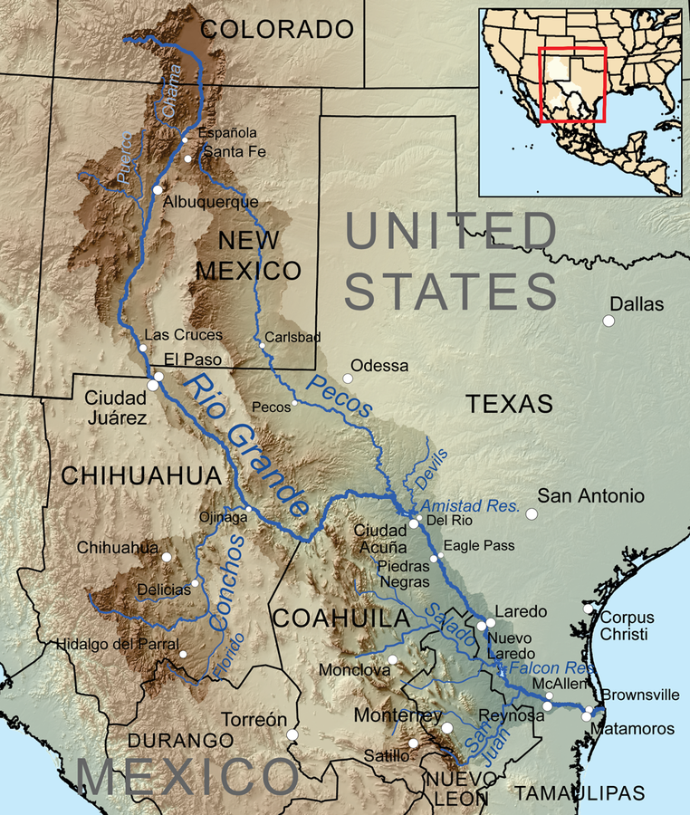
Rio Grande
IN HIGH DEMAND

Will Rogers once described the Rio Grande as “the only river I know of that is in need of irrigating,” a prescient observation considering how fragmented this fabled river has become. At nearly 1,900 miles, the Rio Grande is runner-up only to the combined Missouri-Mississippi system in length within the continental U.S. Or it would be, if it still flowed the length of its channel.
Rio Grande, Rio Bravo, El Rio Bravo del Norte, The Rio. Whatever you call it, however you know it, it is an essential source of water for the American Southwest. At nearly 2,000 miles long, it is the 3rd longest river in the continental US and supports more than 6 million people, including numerous Pueblo and Tribal Nations, cities and towns, agriculture, acequia communities (communal irrigation systems), and countless wildlife species and ecosystems. Along the length of the Rio, communities rely on the river and its tributaries as an important cultural resource and for drinking water, agriculture, abundant recreation, habitat for birds, and it is quite literally the backbone of local economies.
Like other western rivers, the Rio Grande was critical to settlers migrating and making a home in the west, and for the expansion of the railroad. The Rio’s flow was used abundantly, and once the stream itself was appropriated, many water users turned to the connected aquifers and groundwater resources for water. Recognizing water challenges, in 1938, Colorado, New Mexico, and Texas came together to develop the Rio Grande Compact. The Compact requires a proportion of the annual flow of the river to be delivered downstream from Colorado to New Mexico and Texas, an amount that differs based on a complex set of factors and total available water in the system. Water users across the Basin must abide by and follow Compact obligations.
This immensely critical but often overlooked river originates in the alpine ranges of the San Juan Mountains in southern Colorado. It flows east and south through the agriculturally rich San Luis Valley into New Mexico, eventually entering Texas at El Paso, then forming the border with Mexico as it flows east through Big Bend National Park. It finally reaches its terminus at the Gulf, just east of Brownsville.
The Rio Grande is essential to the livelihood of people, economies and the environment, demands from human populations and the impacts of climate change have put the Rio under increasing pressure. Communities along the Rio Grande and its tributaries are acutely aware of their water challenges and have come together to identify innovative solutions, like Frozen Assets, to address these threats. River and riparian restoration projects, agricultural efficiency and modernization projects, recharging the local aquifer, and protecting small streams and wetlands are just some of the initiatives communities along the Rio are undertaking to protect and restore their community’s lifeblood.
Did You know?
The Rio Grande (“Big River”) was named “El Rio Bravo del Norte,” or “The Fierce River of the North,” by Spanish explorers in the 1500s. It is still known as “Rio Bravo” in Mexico.
Despite its name, the Rio Grande averages only about one-fifth as much water as its neighbor, the Colorado River.
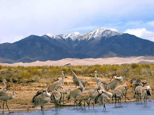
Colorado’s San Luis Valley along the upper Rio Grande is a spring layover for more than 20,000 migrating sandhill cranes and hosts an annual “Crane Fest” at surrounding wildlife refuges.
WHAT STATES DOES THE RIVER CROSS?
New Mexico, Texas
The Backstory
For over a million years, the Rio’s flow was dictated solely by the rhythms of snow and rain, winter and summer. Sometimes, it surged—flooding its banks and ushering sediment downstream. In other years, it whispered its winding way across the landscape. Today, human demands dictate the course and flow of the river. On top of that, changing conditions including increased temperatures, unpredictable precipitation, and limited runoff are altering the flow of the river. For people and wildlife that depend on the Rio Grande, this shift in snow and water availability is a cause for serious concern, increasing the risk and impacts of drought and fire.
Let's stay in touch!
We’re hard at work in the Southwest for rivers and clean water. Sign up to get the most important news affecting your water and rivers delivered right to your inbox.
But climate change isn’t the only threat facing the Rio, its tributaries, and connected groundwater systems. Since the late 20th Century, developers in Colorado have proposed various plans to pump water out of the aquifers that sit below the Rio Grande for expanding communities on the Colorado Front Range. An export scheme would have detrimental impacts to the San Luis Valley, as so much of the local economy is tied to the Valley’s precious water resources. Groundswell on the Rio Grande and Through Line help illustrate the critical connection between local communities and the water resources that run through and below them, and why protecting these resources matter for state of Colorado and the Southwest.
Existing diversions for municipal and agricultural use already claim a significant portion of the Rio Grande’s average annual flow. These diversions, many of which are in need of modernization, can result in disconnected streams with lower flows that also challenge the water users. Increasingly frequent droughts and growing populations could exacerbate the problem. Communities and stakeholders in Colorado, New Mexico, and Texas are working to improve the Rio’s connectivity to benefit communities, agriculture, and the environment. American Rivers is collaboratively working with partners and communities in Colorado, New Mexico and Texas on identifying and implementing multi-faceted watershed health and aquatic connectivity projects for the benefit of human, agriculture, wildlife, and plant ecosystems throughout the Rio Grande Basin and beyond.
America’s Most Endangered Rivers®
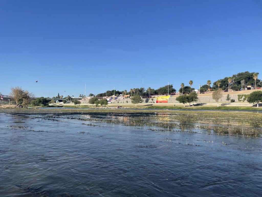
The Lower Rio Grande was listed as one of America’s Most Endangered Rivers of 2025®. The entire Rio Grande is an icon of the West and the lifeblood of the American Southwest, providing water to over 6 million people. The river is a vital economic, cultural, and ecological resource for people and wildlife of the United States and Mexico. Despite its immense value to people and nature, the river has been under constant threat for decades. Today, the danger is nowhere more urgent than in the Lower Rio Grande basin where water scarcity, pollution, and overallocation harm the river and communities that rely on it. We must act now to protect the Lower Rio Grande and all life that depends on it.
Protect the Lower Rio Grande
Urge policymakers to prioritize dedicated federal funding for water security, ecological restoration, and critical repairs to dam infrastructure on the Lower Rio Grande.
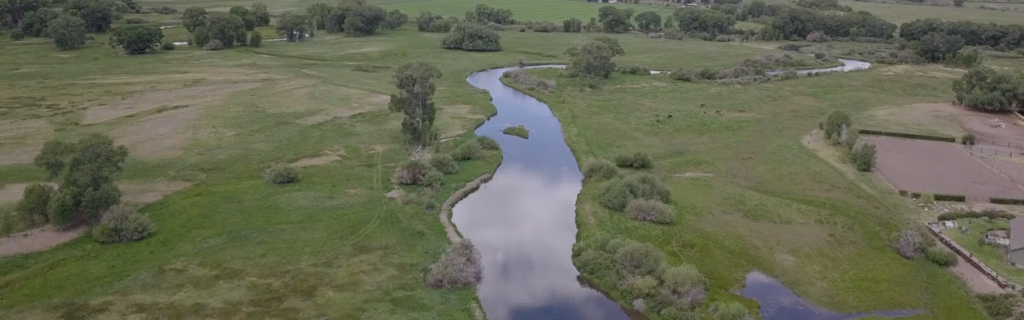
The San Luis Valley
In Colorado’s San Luis Valley, the Rio Grande River supports both people and wildlife. The Valley is home to the Rio Grande National Forest, three National Wildlife Refuges and thousands of acres of private lands supporting well-known and lesser-loved wildlife, including the Rio Grande cutthroat trout and the Sandhill Crane. Over 250 unique species of bird are found in the Great Sand Dunes National Park alone. The iconic Sandhill Crane relies on the Valley’s wetlands, stopping here in the spring and fall to rest and gain strength for their journey between New Mexico and the northern United States and Canada.
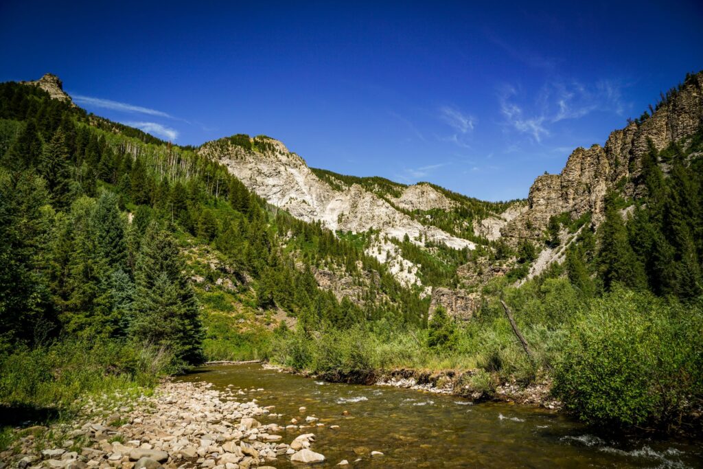
After winding its way through some of the most productive trout waters in southern Colorado, the Rio Grande tumbles into a cavity of sheer-walled canyons carved from the volcanic rock near northern New Mexico’s Taos Pueblo. The box canyons of the Rio Grande del Norte National Monument, designated in 2013, offer dramatic wilderness and important bird sanctuary surrounding some of the finest whitewater in the West for skilled paddlers, highlighting an outdoor recreational mecca that extends downstream along 74 miles of designated Wild & Scenic river.
It’s a solid 600 miles between rapids before the river reaches its lower Wild & Scenic designation surrounding Big Bend National Park along the Texas border with Mexico. Despite being diverted and depleted for hundreds of miles before reaching El Paso, the river gets replenished by Mexico’s Rio Conchos just upstream from Big Bend’s eastern boundary – enough to feed a 191-mile segment of Wild & Scenic River, established in 1978.
Towering limestone walls stretching up to 1,500 feet in the park’s Santa Elena and Mariscal canyons provide much of the scenery amidst a remote, rugged wilderness that extends far beyond Big Bend’s 118-mile river boundary.
Check out the resources below on the San Luis Valley to gain a better understanding of why protecting and preserving the health of the Rio Grande, the viability of aquifers, and the deep history of the San Luis Valley is as critical for communities that rely directly on the river as it is for the state of Colorado and the Southwest.
Through Line
Our film 'Through Line' celebrates both the history and future of water management in the San Luis Valley through the voices of modern managers—specifically a growing number of women managers in a historically male-dominated profession—who are working together to ensure that the needs of communities are met alongside the needs of the river itself, and underscoring that while the challenges may be many, “the future health of the Rio Grande is in good hands.”
Groundswell on the Rio Grande
To help tell the story of the San Luis Valley, the interdependent nature of the people, the river, and water flowing below their feet and the threats facing the Valley’s way of life, American Rivers developed Groundswell on the Rio Grande, an interactive ESRI Story Map that illustrates the connection between people, communities and water. Click belowbelow to discover more about the people, economy, and way of life in the San Luis Valley.
The Future
The Rio Grande undoubtedly faces challenges, from source to sea. However, work is being done across its full length to sustain this essential river.
In Colorado, the Rio Grande ties together generations of people and communities across the San Luis Valley. Brought together by shared ethics of caring for land and water, communities in the Valley depend deeply on the Rio Grande – for their livelihoods, the rich diversity of wildlife and activities they enjoy, and their connection to the rich history of people who have come before them. Communities along the entirety of the Rio Grande are learning to do more with less, and every drop of water works just a little bit harder. A number of planning initiatives within the Valley have identified multi-benefit projects and solutions to help address the challenges they face. This includes water sharing agreements, restoring riparian areas and instream restoration, implementing nature-based solutions, and upgrading agricultural infrastructure. American Rivers has been working closely with partners to respond to local needs and priorities – including developing a database to identify funding opportunities for projects, supporting on-the-ground restoration projects, and analyzing the value of water in the Valley across multiple sectors.
In New Mexico, water partners and stakeholders are working to improve the health of watersheds and rivers through state water quality regulations, regional water planning, and watershed restoration projects. In 2023, a U.S. Supreme Court decision, Sackett v. EPA, stripped away federal clean water protections for many small streams and wetlands nationwide. This had a significant impact in New Mexico as it removed all protections for ephemeral and intermittent streams, which make up the vast majority of streams in the state. In 2024, American Rivers listed the rivers of New Mexico as our “Most Endangered River” to elevate the need for state action to protect these critical systems. The state understood how important this is for New Mexico, and during the 2025 legislative session, the New Mexico Legislature introduced and passed Senate Bill 21, a bill that will ensure protections for waters across the state. In addition to protecting water quality, American Rivers is working with partners in New Mexico to develop a state Environmental Flows program, which would look to improve and expand tools to achieve critical instream flows. Relatedly, American Rivers is facilitating New Mexico’s Aquatic Connectivity Team, which looks to restore in-stream connectivity through barrier removal/modification and working to achieve enough water in the rivers, for safety, wildlife, recreation, and more. Finally, stakeholders have been at work with the Bureau of Reclamation on the Rio Grande New Mexico Basin Study. This is a collaborative study that looks to evaluate and develop strategies to help the river and populations who depend upon it adapt to a future with much less water while supporting the basin’s unique human culture and ecosystems.
Along the Lower Rio Grande in Texas, the river is a vital economic, cultural, and ecological resource for people and wildlife of the United States and Mexico. The springs and streams that feed the river support an invaluable agricultural economy and provide a crucial stop for several of the western hemisphere’s largest migratory flyways. They are home to various highly prized birds and pollinators, including the endangered Monarch butterfly. South Texans rely on the Rio Grande and its reservoirs for their drinking water and as critical recreational and ecological assets. Despite this, investment in the Rio Grande basin remains low compared to other major U.S. river systems. American Rivers is supporting local partners and leaders who are facilitating Texas’s Aquatic Connectivity Team.
Communities throughout the Rio Grande Basin understand the challenges facing their sources of water. A balanced and collaborative approach to water and infrastructure management is needed for the benefit of the river and communities along the Rio Grande. Supporting and prioritizing projects and investments that support river conservation and restoration, water security for people and agriculture, and that improve the resilience of the river, is needed if the once mighty Rio Grande hopes to recover and continue to support all the life that depends on it.