Clearwater River
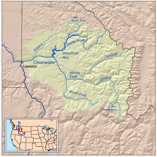
North and South Forks of the Clearwater River
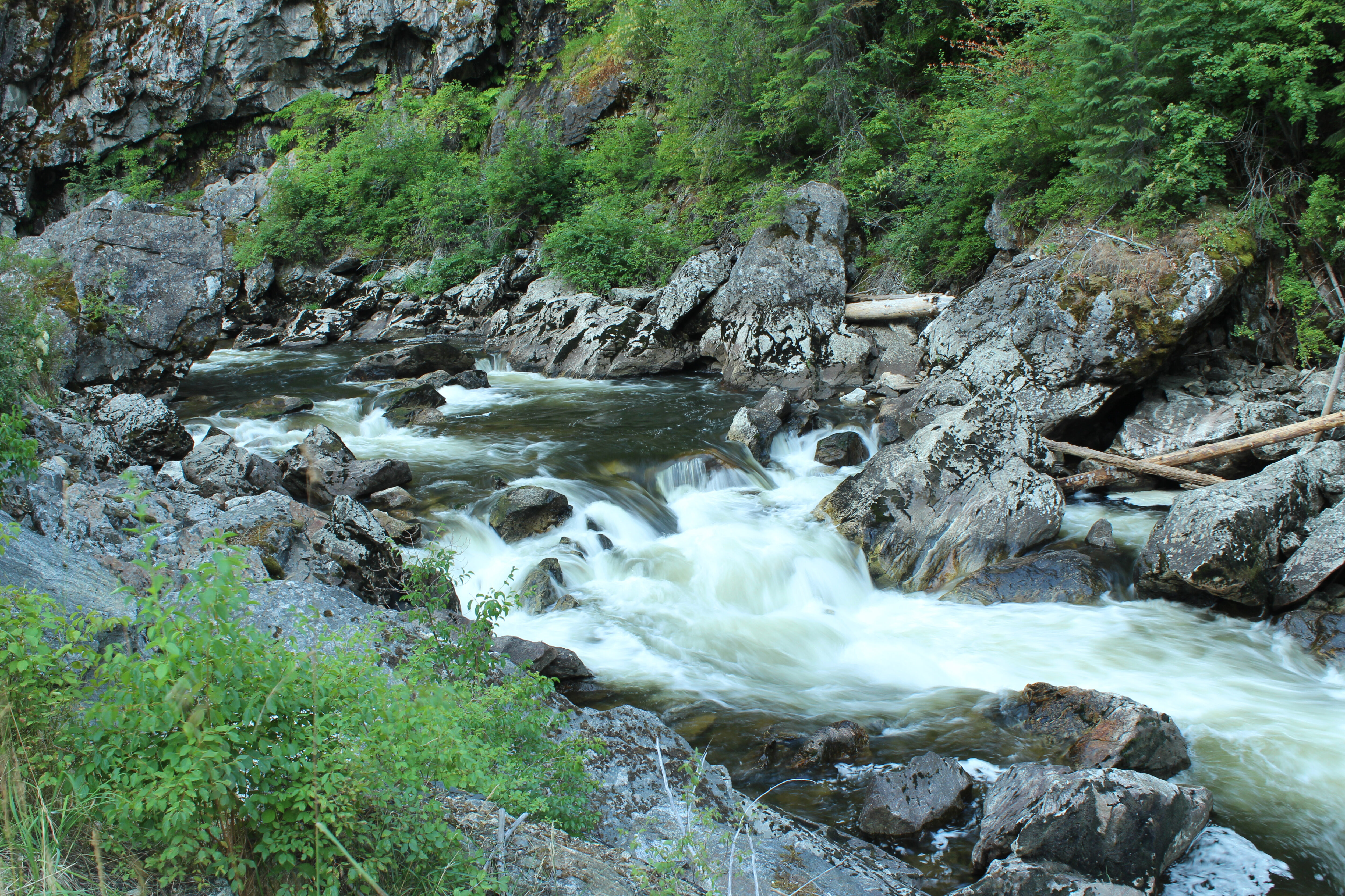
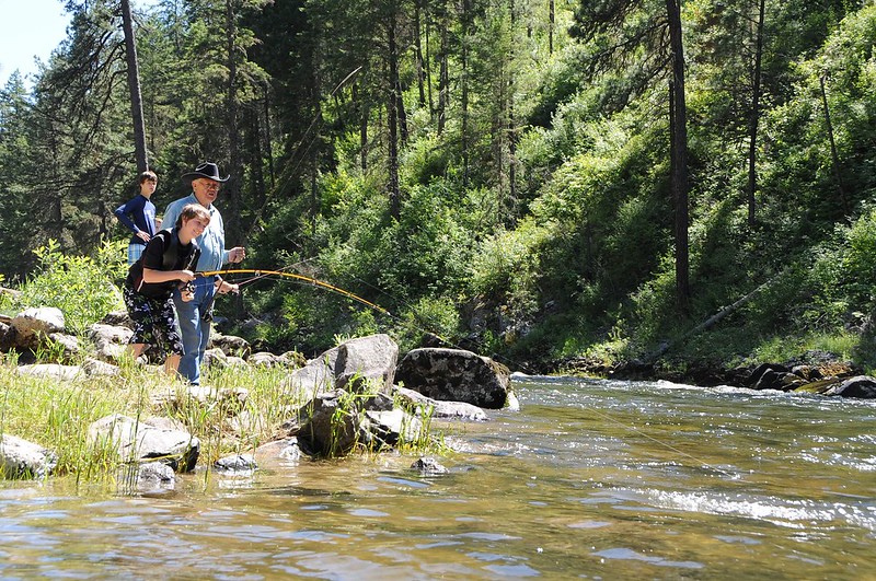
The North and South Forks of the Clearwater River are the largest tributaries to the Middle Fork of the Clearwater, which flows into the Snake River by Lewiston, Idaho. The North Fork Clearwater River begins just west of the Idaho/Montana border, and provides 79 continuous miles of high quality fishable and boatable waters before reaching Dworshak Reservoir. The river offers roadside flatwater-to-expert level paddling opportunities that traverse large boulder rapids, riffles and eddies, cliffs with interesting rock formations, heavy timber, and open meadows. Ample dispersed sites, cedar groves, and white sand beaches provide riverside family camping amid unsurpassed westslope cutthroat trout and endangered bull trout habitat. The North Fork of the Clearwater River supports one of the most substantial populations of threatened Harlequin ducks and is home to endemic plants, such as the chickweed monkey flower and licorice fern. This river basin is culturally and historically significant to the Nez Perce Tribe and includes one of the oldest archeological sites on the southern Columbian Plateau.
What state does the Clearwater River flow through?
Idaho
Did You know?
Mature bull trout are piscivorous, which means that they eat other fish. The world all-tackle record is held by N. Higgins who caught a 32-pound bull trout in Lake Pend Oreille in 1949.
In total, all three forks of the Clearwater River (North, Middle, South) encompass 220 miles of river.
America’s Most Endangered Rivers®
The Clearwater River Basin was named as one of America’s Most Endangered Rivers of 2025. The stunning Clearwater River Basin in the Nez Perce-Clearwater National Forest is home to Chinook salmon, steelhead, westslope cutthroat trout, and bull trout due to its cold, clean, high-elevation streams. The clean water that filters through the old growth forests is one of the most valuable resources the Forest produces. However, 700 miles of rivers and streams within the Clearwater River Basin and the Nez Perce-Clearwater National Forest are at risk from commercial logging, mining, and future dams. The Nez Perce-Clearwater National Forest must issue new guidance to protect the Clearwater River Basin from increased harmful resource extraction.
Protect the Clearwater River Basin
Tell the Nez Perce-Clearwater National Forest to issue new guidance to protect rivers in the Clearwater River Basin from increased harmful resource extraction.
Steelhead anglers flock to the South Fork Clearwater River, originating near Elk City, Idaho, since it provides outstanding angling and essential habitat for Snake River steelhead and bull trout. The turbulent waters of the South Fork Clearwater River are a critical climate refuge for remaining steelhead and salmon populations—this will be where they return when the Lower Snake River Dams are removed. It is one of the only known places on the planet to have populations of the Selway forest snail, an endemic species known only to exist in Idaho County. The river’s fisheries are extremely important to the Nez Perce Tribe. Indigenous and non-indigenous anglers alike find more bank and walk-and-wade fishing than on any other river in the region. In addition to fishing, red tea-colored headwaters from the Red River upstream provide lazy tubing and swimming for area families on hot summer days.
Let's Stay in Touch!
We’re hard at work in the Northern Rockies for rivers and clean water. Sign up to get the most important news affecting your water and rivers delivered right to your inbox.
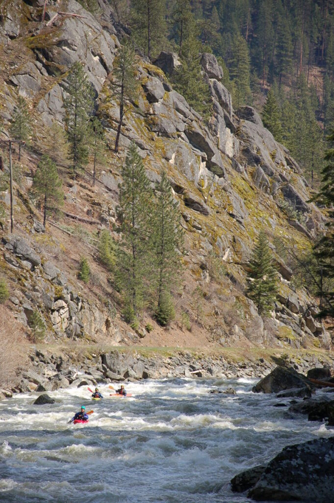
As the river descends towards its confluence with the Middle Fork Clearwater River, it boasts robust whitewater paddling with roadside access along its Golden Canyon and Mickey Mouse sections, which are well-known among kayakers and rafters. Boulder-strewn rapids take expert paddlers on a fast and frothy plunge between rocky canyon walls. The South Fork Clearwater River also has a lengthy mining history dating back to 1861 when placer gold was found along the river and thousands of people rushed to what is now Elk City. Placer tailing piles can still be seen along the river in its upper-most reaches.
The backstory
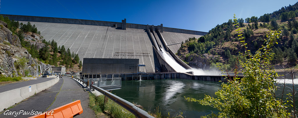
At 717 feet high, Dworshak Dam is the third tallest dam in the United States. It was constructed in 1973 and, lacking fish ladders, completely obstructs fish passage and migration to the North Fork Clearwater River and its tributaries. Its recent history of damming and the number of yet-undeveloped potential dam sites remaining on the river pose a notable threat of future hydroelectric or water storage facility construction.
Grangeville (Harpster) Dam was built on the South Fork Clearwater River in 1910 for hydroelectricity generation. In 1963, the dam was demolished, restoring the river’s populations of Chinook salmon and steelhead. Although the entire river and its headwater tributaries are now free-flowing, the threat of future dams and diversions lingers. Elk City, near its headwaters, remains one of the state’s most active gold placer mining areas with 59 claims. Most claims are along the river.
The Future
Within north central Idaho, the North and South Forks of the Clearwater River are now the only remaining major rivers at risk of future mining, dam building, and streamside logging. From 1980 to 2025, both of these rivers were protected as eligible Wild and Scenic Rivers under the former Nez Perce-Clearwater Forest Plan, which granted decades of protection by safeguarding the fishing, boating, and camping opportunities these rivers provide. In January 2025, however, the Nez Perce-Clearwater National Forest released its new plan which heavily favors logging and extractive industries and strips protections from both of these rivers along with 86 others—a total loss of nearly 700 miles of river protections. The new forest plan will govern the management of the Nez Perce Clearwater National Forest for at least the next 20 years, unless it is invalidated through litigation.