Mining threatens clean water, salmon for third year in a row
April 14, 2020
Contact:
Scott Bosse, American Rivers, (406) 570-0455, sbosse@americanrivers.org
Nic Nelson, Idaho Rivers United, (208) 343-7481, nic@idahorivers.org
Evan Stafford, American Whitewater, (970) 420-5377, evan@americanwhitewater.org
Fred Coriell, Save the South Fork Salmon, (208) 315-3630, savethesouthfork@gmail.com
Washington, D.C. – For the third year in a row, American Rivers named the South Fork of the Salmon River among America’s Most Endangered Rivers®. The report cites the threat that a massive open-pit gold mine in the river’s headwaters poses to endangered fish and some of Idaho’s most beloved rivers. American Rivers and its partners called on the U.S. Forest Service to protect the South Fork Salmon by denying the mining proposal.
“Naming the South Fork of the Salmon as one of America’s Most Endangered Rivers for three consecutive years sends a powerful message,” said Scott Bosse with American Rivers. “This is a river that has slowly been on the mend from past mining activity that had devasting impacts on its water quality and resident and migratory fish populations. The last thing it needs right now is a huge new open pit mine that’s being disguised as a restoration project. It’s time for the U.S. Forest Service to kill this project.”
Gold and antimony mining began at the Stibnite Mine near the rivers’ headwaters in the late 1800s. Since then, levels of arsenic, mercury, cyanide and antimony in the surrounding creeks and rivers have been high. After decades and $13 million spent to restore and reclaim legacy tailing and waste rock piles, heavy metals are on the decline. A Canadian mining company named Midas Gold has proposed reopening and expanding the open-pit mine. If allowed to proceed, Stibnite would unearth more arsenic, mercury and antimony that, through natural processes and potential accidents and spills, would deposit directly or indirectly into the South Fork of the Salmon River. The company proposes to route the river into a 0.8 mile long tunnel to facilitate mining beneath the riverbed, and mine wastes stored on site would bury hundreds of acres of aquatic habitat. These impacts will directly affect the fisheries, recreation economy and cultural importance of South Fork waters.
“The South Fork of the Salmon River and its tributaries are critical habitat for Chinook Salmon, Steelhead, and Bull Trout; all are listed species under the Endangered Species Act. It hosts high-elevation spawning habitat, which is especially important in the face of a changing climate. These fish are vital to the nutrient cycle in the watershed’s ecosystem. The cumulative impacts, including burying tributaries under million of tons of mine waste must be evaluated without the influence of a mining company’s bottom line,” said Fred Coriell with Save the South Fork Salmon.
“The South Fork of the Salmon River is a quintessential whitewater paddling watershed, with numerous quality roadside runs and one of the west’s most classic multi-day self-support trips. It’s crystal clear free-flowing water, wild scenery, and incredible rapids make it a veritable whitewater paradise and a draw for paddlers worldwide. The South Fork also flows directly into the Wild and Scenic Salmon River, where mining contaminants would affect not only the water quality of the incredible South Fork, but also of the Main Salmon, one of the most sought after permitted multi-day raft runs in the country, second only to the Grand Canyon of the Colorado. Multiple rural economies in Idaho rely heavily on these forms of river recreation intimately tied to the pristine water quality and unmarred wilderness of the Salmon River drainage,” said Evan Stafford with American Whitewater.
In spring 2020, the Payette National Forest will release a draft environmental impact statement on Midas Gold’s proposed project, followed by a public comment period. American Rivers and its partners call on the U.S. Forest Service to protect the health of, and investment in, the South Fork of the Salmon River, the water quality of the Wild and Scenic Salmon River, and the long-term recovery of endangered fish by prohibiting the reopening and expansion of the Stibnite Mine.
The South Fork of the Salmon River flows 86 miles from the Salmon River Mountains to the Wild and Scenic Salmon River. Despite a long history of logging, road building and mining, the South Fork Salmon boasts clear, free-flowing waters and undisturbed spawning habitat for endangered bull trout, chinook salmon and steelhead. It supports a thriving recreation economy in central Idaho. The river has also been the ancestral fishing and hunting grounds for Shoshone Bannock, Shoshone Paiute and Nez Perce tribes since time immemorial.
The annual America’s Most Endangered Rivers report is a list of rivers at a crossroads, where key decisions in the coming months will determine the rivers’ fates. Over the years, the report has helped spur many successes including the removal of outdated dams, the protection of rivers with Wild and Scenic designations, and the prevention of harmful development and pollution.
Other rivers in the region listed as most endangered in past years include the South Fork of the Salmon River (2018, 2019), Middle Fork Flathead River (2017), Smith River (2015, 2016, 2018), and the Clearwater and Lochsa rivers (2014).
AMERICA’S MOST ENDANGERED RIVERS® OF 2020
#1 Upper Mississippi River (Illinois, Iowa, Missouri, Minnesota, Wisconsin)
Threat: Climate change, poor flood management
#2 Lower Missouri River (Missouri, Iowa, Nebraska, Kansas)
Threat: Climate change, poor flood management
#3 Big Sunflower River (Mississippi)
Threat: Yazoo pumps project
#4: Puyallup River (Washington)
Threat: Electron Dam
#5: South Fork Salmon River (Idaho)
Threat: Gold mine
#6: Menominee River (Michigan, Wisconsin)
Threat: Open pit sulfide mining
#7: Rapid Creek (South Dakota)
Threat: Gold mining
#8: Okefenokee Swamp (Georgia, Florida)
Threat: Titanium mining
#9: Ocklawaha River (Florida)
Threat: Rodman Dam
#10: Lower Youghiogheny River (Pennsylvania)
Threat: Natural gas development
River of the Year: Delaware River (Pennsylvania, New Jersey, New York, Maryland)
Honored as a national success story for restoration and a model for equitable and innovative clean water solutions.
ABOUT AMERICAN RIVERS
American Rivers believes every community in our country should have clean water and a healthy river. Since 1973, we have been protecting wild rivers, restoring damaged rivers and conserving clean water for people and nature. With headquarters in Washington, D.C., and offices across the country, we are the most effective river conservation organization in the United States, delivering solutions that will last for generations to come. Find your connections at AmericanRivers.org.
Mining threatens cities’ water supplies and Menominee Tribe sacred sites
April 14, 2020
Contact:
Shanyn Viars, American Rivers, (607) 426-8283, sviars@americanrivers.org
Dale and Lea Jane Burie, Coalition to SAVE the Menominee River (615) 512-3506, jointherivercoalition@gmail.com
Dr. Al Gedicks, Wisconsin Resources Protection Council, (608) 784-4399, agedicks@eagle.uwlax.edu
Allison Werner, River Alliance of WI, (608) 257-2424 x113, awerner@wisconsinrivers.org
Washington, D.C. – For the second time in four years, American Rivers named the Menominee River among America’s Most Endangered Rivers®, citing the threat of a proposed metallic sulfide mine to drinking water supplies and sacred tribal sites. American Rivers and its partners called on Michigan’s Environment, Great Lakes and Energy (MEGLE) agency to deny the permit for this mining project and protect local communities and the cultural significance of the Menominee River.
“America’s Most Endangered Rivers is a call to action. This mine poses an unacceptable risk to the Menominee River and Lake Michigan,” said Shanyn Viars with American Rivers. “We cannot allow mine tailings to demolish Menominee Indian Tribe of Wisconsin’s sacred sites or send toxic waste into drinking water supplies, potentially risking millions of people.”
A Canadian exploration company, Aquila Resources, Inc., seeks permits for a metallic sulfide mine on the banks of the Menominee River, near Stephenson, Michigan. Known as the Back Forty project, the proposed mine and tailings dam would encompass 1,087 acres — the size of 1,435 football fields. If toxic acid mine drainage spilled out of the Back Forty tailings dam, it would send heavy metals linked to cancer, respiratory failure, and diseases of the nervous system, brain, heart, lungs, liver and kidneys into ancient tribal ceremonial sites, the Menominee River and ultimately Lake Michigan. Currently, it is unclear if a contingency plan has been defined by MEGLE.
The Menominee Indian Tribe of Wisconsin, the Coalition to SAVE the Menominee River, Inc., along with communities and other organizations in Wisconsin and Michigan, are fighting for their right to a clean river, joined in opposition to the exploration company, Aquila Resources, Inc. American Rivers also called on Wisconsin Governor Tony Evers and Michigan Governor Gretchen Whitmer to oppose this harmful project.
“After many years of metallic sulfide mining, with every mine proven to have polluted nearby water and contaminated the environment, we should recognize these ingredients as a recipe for disaster,” said Dale Burie, President, Coalition to SAVE the Menominee River, Inc.
“The potential for a catastrophic failure of Aquila’s proposed tailings dam threatens the Menominee River, the largest watershed in the Upper Peninsula, downstream Lake Michigan and decades of clean water efforts. In addition, the sacred sites of Native Americans should be ‘no-go-areas’, protected from destructive mining projects,” said Al Gedicks, Executive Secretary, Wisconsin Resources Protection Council.
“The risks to our waters are too high for this project to go forward. It’s not a matter of if pollution will occur, it is a question of when it will occur. Long-term protection of drinking water, cultural resources, fisheries, and economies are far more important than this short-term project,” said Allison Werner, Policy and Advocacy Director, River Alliance of Wisconsin.
A world-class smallmouth bass fishery, the Menominee River supplies drinking water for 24,000 people in Marinette, Wisconsin, and Menominee, Michigan. Winding through sacred tribal lands, the river is especially meaningful to the Menominee Indian Tribe of Wisconsin, whose 10,000 years of history, culture and heritage began where the river spills into Lake Michigan. Today, the tribe plays an active role in land management and river stewardship.
The annual America’s Most Endangered Rivers report is a list of rivers at a crossroads, where key decisions in the coming months will determine the rivers’ fates. Over the years, the report has helped spur many successes including the removal of outdated dams, the protection of rivers with Wild and Scenic designations, and the prevention of harmful development and pollution.
Other rivers in the region listed as most endangered in past years include the Boundary Waters (2018), Mississippi River (2020, 2019), Kinnickinic River (2018), and the St. Louis River (2016).
AMERICA’S MOST ENDANGERED RIVERS® OF 2020
#1 Upper Mississippi River (Illinois, Iowa, Missouri, Minnesota, Wisconsin)
Threat: Climate change, poor flood management
#2 Lower Missouri River (Missouri, Iowa, Nebraska, Kansas)
Threat: Climate change, poor flood management
#3 Big Sunflower River (Mississippi)
Threat: Yazoo pumps project
#4: Puyallup River (Washington)
Threat: Electron Dam
#5: South Fork Salmon River (Idaho)
Threat: Gold mine
#6: Menominee River (Michigan, Wisconsin)
Threat: Open pit sulfide mining
#7: Rapid Creek (South Dakota)
Threat: Gold mining
#8: Okefenokee Swamp (Georgia, Florida)
Threat: Titanium mining
#9: Ocklawaha River (Florida)
Threat: Rodman Dam
#10: Lower Youghiogheny River (Pennsylvania)
Threat: Natural gas development
River of the Year: Delaware River (Pennsylvania, New Jersey, New York, Maryland)
Honored as a national success story for restoration and a model for equitable and innovative clean water solutions.
ABOUT AMERICAN RIVERS
American Rivers believes every community in our country should have clean water and a healthy river. Since 1973, we have been protecting wild rivers, restoring damaged rivers and conserving clean water for people and nature. With headquarters in Washington, D.C., and offices across the country, we are the most effective river conservation organization in the United States, delivering solutions that will last for generations to come. Find your connections at AmericanRivers.org.
Mining threatens clean water, sacred sites
April 14, 2020
Contact: Chris Williams, American Rivers, 202-347-7550
Dr. Lilias Jarding, Black Hills Clean Water Alliance, 605-787-2872
A Gay Kingman, Great Plains Tribal Chairmen’s Association, Inc., 605- 484-3036
Carla R. Marshall, Dakota Rural Action Black Hills Chapter, 605- 545-1430
Washington, D.C. – American Rivers today named Rapid Creek in the Black Hills among America’s Most Endangered Rivers®. The report cites the threat that mining poses to clean water and sacred sites. American Rivers and its partners called on the U.S. Forest Service to complete thorough Environmental Impact Statements on proposed mining projects, including formal consultation with sixteen tribal nations.
“America’s Most Endangered Rivers is a call to action,” said Chris Williams, senior vice president for conservation at American Rivers. “Mining could devastate Rapid Creek’s clean water, fish and wildlife and sacred cultural sites. The Forest Service must seriously consider these risks and listen to the tribal nations who have cared for the Black Hills since time immemorial.”
Today, large-scale gold mining must be stopped from moving south into the Rapid Creek watershed, where it would threaten the Oceti Sakowin (The Great Sioux Nation) homelands, treaty territory and present-day reservation lands and rural and ranching communities.
Four companies are applying to explore for gold in the central Black Hills, at least two of which are in the Rapid Creek watershed— Mineral Mountain Resources and F3 Gold. Mineral Mountain Resources has mining claims on over 7,500 acres and is drilling on private land near Pe’ Sla, a major cultural site of the Lakota people. The site is so important that the Lakota and Dakota tribes purchased a portion of Pe’ Sla in order to protect it, without regard to the fact that it was land under the 1868 Fort Laramie Treaty. F3 Gold has 2,485 mining claims and wants to explore above the inlet to Pactola Reservoir; its claims extend into the lake.
A mining spill (including cyanide, arsenic, or other heavy metals) could pollute Rapid Creek and its related aquifer. The area’s major population center, tourism and a large Air Force Base that rely on clean drinking water supplies, could suffer serious consequences. American Rivers and its partners called on the Forest Service to conduct thorough Environmental Impact Statements on the proposed mining projects, including formal consultation with sixteen tribal nations.
“Water is Life. Mining for gold poses a serious threat to our sacred water from Rapid Creek. Our drinking water, our environment, our land and the health of hundreds of people are at stake. Instead of polluting Rapid Creek, which connects to the Cheyenne River and the Missouri River, the longest river in America, we should be cleaning up our waters. We simply cannot allow greed and the quest for gold to endanger our water and our lives,” said A. Gay Kingman, Executive Director, Great Plains Tribal Chairman’s Association, Inc.
“Water is our first medicine and we need to recognize freshwater, such as Rapid Creek, as the living entity that she is. We must protect her like our life, and the lives of future generations, of all species, depend on it – because it does,” said Carla Rae Marshall, Lakota Grandmother Earth Advocate.
Gold mining has a difficult history in the Black Hills. After the 1868 Fort Laramie Treaty had reserved the area to the Lakota, Dakota and Nakota peoples in perpetuity, non-indigenous people proceeded to enter the area to explore for gold. The Black Hills, known to the Lakota (Teton Sioux) as, “The Heart of Everything that Is,” have been sacred to Indigenous peoples since time immemorial. For over 150 years, the U.S. Government has tried to get legal title to the Black Hills. The Lakota have rejected the offer of a settlement. In the meantime, billions of dollars of gold were mined from the northern Black Hills, without compensation to the Great Sioux Nation. Mining operations have harmed the land, wildlife and water, and a former gold mine is now a Superfund site.
Rapid Creek (in Lakota it is called Mniluzuhan – Mni for “water” and Luzuhan for “fast) is approximately 86 miles long and originates in the ecologically rich Black Hills. It winds east into Pactola Reservoir, a recreation area and drinking water source, flows through Rapid City, the second largest city in South Dakota, and then joins the Cheyenne River, a tributary of the Missouri River. The creek’s watershed includes rural and tribal communities, Ellsworth Air Force Base and Box Elder (collective populations of 89,408) – which all rely on Rapid Creek water.
The annual America’s Most Endangered Rivers report is a list of rivers at a crossroads, where key decisions in the coming months will determine the rivers’ fates. Over the years, the report has helped spur many successes including the removal of outdated dams, the protection of rivers with Wild and Scenic designations, and the prevention of harmful development and pollution.
Other rivers in the region listed as most endangered in past years include the South Fork of the Salmon River (2018, 2019), Middle Fork Flathead River (2017), Smith River (2015, 2016, 2018), and the Clearwater and Lochsa rivers (2014).
AMERICA’S MOST ENDANGERED RIVERS® OF 2020
#1 Upper Mississippi River (Illinois, Iowa, Missouri, Minnesota, Wisconsin)
Threat: Climate change, poor flood management
#2 Lower Missouri River (Missouri, Iowa, Nebraska, Kansas)
Threat: Climate change, poor flood management
#3 Big Sunflower River (Mississippi)
Threat: Yazoo pumps project
#4: Puyallup River (Washington)
Threat: Electron Dam
#5: South Fork Salmon River (Idaho)
Threat: Gold mine
#6: Menominee River (Michigan, Wisconsin)
Threat: Open pit sulfide mining
#7: Rapid Creek (South Dakota)
Threat: Gold mining
#8: Okefenokee Swamp (Georgia, Florida)
Threat: Titanium mining
#9: Ocklawaha River (Florida)
Threat: Rodman Dam
#10: Lower Youghiogheny River (Pennsylvania)
Threat: Natural gas development
River of the Year: Delaware River (Pennsylvania, New Jersey, New York, Maryland)
Honored as a national success story for restoration and a model for equitable and innovative clean water solutions.
ABOUT AMERICAN RIVERS
American Rivers believes every community in our country should have clean water and a healthy river. Since 1973, we have been protecting wild rivers, restoring damaged rivers and conserving clean water for people and nature. With headquarters in Washington, D.C., and offices across the country, we are the most effective river conservation organization in the United States, delivering solutions that will last for generations to come. Find your connections at AmericanRivers.org.
Mining threatens, fish and wildlife habitat; wetlands; water quality and flow
Contact: Ben Emanuel, American Rivers, 706-340-8868
Christian Hunt, Defenders of Wildlife 828-417-0862
Rena Ann Peck, Georgia River Network, 404-395-6250
Alice Miller Keyes, One Hundred Miles, 912-230-6494
Alex Kearns, St. Marys EarthKeepers, 912-322-7367
Washington, D.C. –American Rivers today named the Okefenokee Swamp and St. Marys River among America’s Most Endangered Rivers®, citing the threat titanium mining would pose to the waterways’ clean water, wetlands and wildlife habitat. American Rivers and its partners called on the U.S. Army Corps of Engineers and other permitting agencies to deny any proposals that risk the long-term protection of the Okefenokee Swamp and St. Marys River.
“America’s Most Endangered Rivers is a call to action,” said Ben Emanuel, Atlanta-based Clean Water Supply Director with American Rivers. “Some places are simply too precious to allow risky mining operations, and the edge of the unique Okefenokee Swamp is one. The Army Corps of Engineers must deny the permit to save this national treasure.”
The annual America’s Most Endangered Rivers report is a list of rivers at a crossroads, where key decisions in the coming months will determine the rivers’ fates. Over the years, the report has helped spur many successes including the removal of outdated dams, the protection of rivers with Wild and Scenic designations, and the prevention of harmful development and pollution.
Rena Ann Peck, Executive Director of Georgia River Network, explains “The Okefenokee Swamp is like the heart of the regional Floridan aquifer system in southeast Georgia and northeast Florida. The life-force of water from the Okefenokee Swamp not only flows into the St. Marys River to the Atlantic Ocean, but also into the Suwannee River to the Gulf of Mexico. Mining on Trail Ridge can draw down the water level of the Okefenokee Swamp and dewater headwater wetlands and tributaries and the rivers they feed, destroying natural habitat for federally listed species and providing dry peat fueling uncontrollable fires.”
In 2019, Twin Pines Minerals submitted an initial application to the U.S. Army Corps of Engineers to operate on 2414-acres, located 1.7 miles from the refuge boundary. Though Twin Pines submitted a revised application in 2020 in which it slightly reduced the size of the first project area, government agencies expect operations to eventually grow to 12,000-acres, potentially coming within 400-feet of the swamp itself.
The U.S. Fish and Wildlife Service and U.S. Environmental Protection Agency anticipate that “permanent” and “unacceptable” damage could befall the Okefenokee Swamp. The destruction of wetlands and tributaries would also degrade the St. Marys River, which is renowned for its high quality of water and habitat for endangered Atlantic and shortnose sturgeon.
Alex Kearns, Chair of the St. Marys EarthKeepers, states, “The St. Marys is an extraordinarily beautiful and fragile blackwater river that has shaped the history, economy, and culture of our region. It surfaces as a tiny stream known as “River Styx” and flows from the western edge of Trail Ridge, the primordial remnants of a barrier island system, and into the southeastern Okefenokee Swamp. From there it flows south, then east, then north, then east-southeast until finally, after a journey of 125 river-miles, it delivers its unique brew into the Atlantic near St. Marys, GA and Fernandina Beach FL. It is essential, irreplaceable and cherished.”
The nature of heavy mineral sand mining requires freshwater sources, and the most reliable source of millions of gallons of water in southeast Georgia is the Floridan aquifer. Withdrawals of this scale could lower the water table of the Okefenokee Swamp and impact the natural flows of the Suwannee and St. Marys rivers. Groundwater drawdowns could also exacerbate wildfire frequency and intensity and contribute to droughts, thus compounding the impacts of climate change.
“The mining industry has no place on the doorstep of the Okefenokee,” states Christian Hunt, Southeast Representative for Defenders of Wildlife. “The Okefenokee and St. Marys River support local economies and thousands of species because they’ve not been spoiled by the type of development proposed today. Twin Pines cannot be allowed to gamble with the health of these world-renowned resources.”
“The Okefenokee Swamp and St. Marys River define the communities and families of Southeastern Georgia,” adds Alice M. Keyes, VP of Coastal Conservation with One Hundred Miles. “Generations of Georgians have depended on this natural asset for food, jobs, and quality of life. No one corporation should be permitted to destroy that legacy for short-term gain.”
The Okefenokee Swamp has been designated as a National Natural Landmark, a Wetland of International Importance, and a potential UNESCO World Heritage Site. Okefenokee National Wildlife Refuge is the largest National Wildlife Refuge in the eastern United States. Unlike the Everglades and Great Dismal Swamp, the function and health of the swamp remains essentially unchanged and has not been compromised by agriculture or industrial development. For this reason, the Okefenokee offers an unparalleled wilderness and paddling experience.
Other rivers in the region listed as most endangered in past years include the Ocklawaha River (2020), Apalachicola River (2016 , 2002, 2000 & 1997), St. Johns River (2008), Altamaha River (2002), Peace River (2004), and Flint River (2016 , 2012, 2000, 1998 & 1996)
AMERICA’S MOST ENDANGERED RIVERS® OF 2020
#1 Upper Mississippi River (Illinois, Iowa, Missouri, Minnesota, Wisconsin)
Threat: Climate change, poor flood management
#2 Lower Missouri River (Missouri, Iowa, Nebraska, Kansas)
Threat: Climate change, poor flood management
#3 Big Sunflower River (Mississippi)
Threat: Yazoo pumps project
#4: Puyallup River (Washington)
Threat: Electron Dam
#5: South Fork Salmon River (Idaho)
Threat: Gold mine
#6: Menominee River (Michigan, Wisconsin)
Threat: Open pit sulfide mining
#7: Rapid Creek (South Dakota)
Threat: Gold mining
#8: Okefenokee Swamp and St Marys River (Georgia, Florida)
Threat: Titanium mining
#9: Ocklawaha River (Florida)
Threat: Rodman Dam
#10: Lower Youghiogheny River (Pennsylvania)
Threat: Natural gas development
River of the Year: Delaware River (Pennsylvania, New Jersey, New York, Maryland)
Honored as a national success story for restoration and a model for equitable and innovative clean water solutions.
Rodman Dam threatens clean water and habitat for fish and manatees
April 14, 2020
Contact: Erin McCombs, American Rivers, 828-649-7887
Lisa Rinaman, St. Johns Riverkeeper, 904-509-3260
Captain Erika Ritter, A Cruising Down the River, 352-299-0282
Washington, D.C. –American Rivers today named the Ocklawaha River among America’s Most Endangered Rivers®, citing the Rodman Dam as a threat to clean water, wildlife habitat, and recreation.
“America’s Most Endangered Rivers is a call to restore rivers for today’s communities and future generations,” said Erin McCombs with American Rivers. “The Ocklawaha River is a Florida treasure, but this obsolete dam is holding back the river’s full potential to revitalize local communities and a healthy environment. Governor DeSantis has a historic opportunity to bring the river back to life.”
In 1968, the natural connection of the Ocklawaha River to the St. Johns River was severed by the Rodman Dam, part of the Cross Florida Barge Canal that was never built. The dam flooded over 7,500 acres of forested wetlands, 20 springs and 16 miles of the Ocklawaha River. It also caused significant harm to threatened and endangered species, adjacent wetlands and forests, 12 miles of downstream river and wetlands, and the St. Johns River. While the reservoir behind the dam, Rodman Pool, became a popular bass fishing destination, the pool has never functioned as a natural lake and must be artificially maintained and drained every three to four years to kill nuisance aquatic vegetation with herbicides. In addition, fish diversity and quantity have declined due to water quality degradation and loss of floodplain habitat.
Governor DeSantis has demonstrated his commitment to the improvement of Florida’s water resources by dedicating millions of dollars to support Everglades restoration. Lending his support in Northeast Florida for Ocklawaha River restoration is essential to the economy and health of three outstanding rivers and one of the state’s largest first magnitude springs.
“Reconnecting and restoring the St. Johns, Ocklawaha and Silver Springs by breaching the Rodman Dam offers a much-needed stimulus project that provides jobs, increases visitor traffic and restores three of Florida’s most loved waterways creating an unprecedented environmental and economic lift to Northeast Florida during a critical point in our history,” said Lisa Rinaman with St. Johns Riverkeeper.
“There is no other river in America quite like the Ocklawaha River,” said river Captain Erika Ritter. “Restoration will bring back our native fish like the striped bass, provide habitat for threatened manatees, save the cypress forest and restore a lost blueway for motorboats and paddlers from the Atlantic Ocean to the Harris Chain of Lakes.” As a young child, Ritter saw the “crusher crawler” machine destroy part of the large cypress forest near her river home.
The 74-mile river rises from the swamps and lakes of north-central Florida, winds along the Ocala National Forest, connects with the spring-fed Silver River and travels east near Orange Springs before reaching the St. Johns River, an American Heritage River. The Timucua people inhabited the region centuries ago, and in more recent times the Creek, Choctaw and several other tribes displaced from their lands by European settlers formed the Seminole nation on the banks of the Ocklawaha. Much of the river remains largely undisturbed, providing natural landscapes of hydric hammocks, long leafed and slash pine, and the sugar sandy soils that give Florida its white sand beaches. The fossil remains of paleo-mammals like mastodons and saber-toothed tigers are often found near the river.
The annual America’s Most Endangered Rivers report is a list of rivers at a crossroads, where key decisions in the coming months will determine the rivers’ fates. Over the years, the report has helped spur many successes including the removal of outdated dams, the protection of rivers with Wild and Scenic designations, and the prevention of harmful development and pollution.
Other rivers in the region listed as most endangered in past years include the Okefenokee/ St Marys River (2020), St. Johns River (2008), Apalachicola River (2016, 2002, 2000 & 1997), Peace River (2004), Caloosahatchee River (2006) and the Chattahoochee River (2016, 2012, 2000, 1998, & 1996).
AMERICA’S MOST ENDANGERED RIVERS® OF 2020
#1 Upper Mississippi River (Illinois, Iowa, Missouri, Minnesota, Wisconsin)
Threat: Climate change, poor flood management
#2 Lower Missouri River (Missouri, Iowa, Nebraska, Kansas)
Threat: Climate change, poor flood management
#3 Big Sunflower River (Mississippi)
Threat: Yazoo pumps project
#4: Puyallup River (Washington)
Threat: Electron Dam
#5: South Fork Salmon River (Idaho)
Threat: Gold mine
#6: Menominee River (Michigan, Wisconsin)
Threat: Open pit sulfide mining
#7: Rapid Creek (South Dakota)
Threat: Gold mining
#8: Okefenokee Swamp (Georgia, Florida)
Threat: Titanium mining
#9: Ocklawaha River (Florida)
Threat: Rodman Dam
#10: Lower Youghiogheny River (Pennsylvania)
Threat: Natural gas development
River of the Year: Delaware River (Pennsylvania, New Jersey, New York, Delaware)
Honored as a national success story for restoration and a model for equitable and innovative clean water solutions.
The Many Voices of the Ocklawaha River
Free the Ocklawaha Coalition: “Thirty-three organizations representing millions of supporters have pulled together to make restoration a reality as we move towards the 50th anniversary of the halting of the Cross Florida Barge Canal. The Rodman/Kirkpatrick Dam, never used for its intended purpose, is past its life expectancy. It is time to come together for the benefit of the economy and the environment.” – Margaret Hankinson Spontak, Chair, Free the Ocklawaha Coalition.
Dam History: “It was my grandmother who rallied 162 scientists in 1970 to convince President Nixon to stop the canal that was one third completed. As founding President of Florida Defenders of the Environment (FDE), she worked for 30 years to reconnect three rivers that were severed by the Rodman Dam. As current President of FDE my goal is to restore the Ocklawaha River with aligned stakeholders to protect wildlife and the environment through building an understanding of the interconnectedness of rivers, forests, animals, people and wellbeing.” – Jennifer Carr, FDE President and Biosecurity Research & Extension lab manager at UF Entomology & Nematology Dept.
Economic and Environmental Impact: “The recent Ocklawaha River drawdown gave us a glimpse of what the river once was and could be again. At a time when Florida’s water issues are at the forefront, restoring this special part of wild Florida makes ecological and economic sense.” – Julie Wraithmell, Executive Director, Audubon Florida
Fish: “Silver Springs will never be fully restored without the removal of the Rodman/Kirkpatrick Dam on the Ocklawaha River. Migratory fish from the Atlantic Ocean and St. Johns River, including striped bass, channel catfish, striped mullet, American shad, American eels, and Atlantic sturgeon, are critical to a productive Silver Springs ecosystem. Large schools of catfish and mullet, swimming over algae-free grasses, will provide a visible confirmation of restoration for the public riding the iconic Glass Bottom Boats at Silver Springs.”- Dr. Robert Knight, Executive Director, Florida Springs Institute.
Manatees: “We can address the greatest long-term threat to Florida’s manatees — loss of warm water habitat to survive during cold weather – by restoring natural flow of the Ocklawaha River and its 20 freshwater springs. Restoration would provide vital winter refuge to an estimated 1,000 manatees that shelter at impermanent power plants.” – Elizabeth Fleming, Senior Florida Representative, Defenders of Wildlife.
Recreation Use: “A University of Florida study on the Ocklawaha River, not including Silver Springs State Park, confirmed that ‘the economic impact from eco-tourists who use the natural portions of the Ocklawaha River is twice that of the anglers and boaters at Rodman Reservoir.’ Use of the reservoir sites has been declining since records began in 2004. Returning the historic fish and attracting hundreds of manatees to Silver Springs will boost visitor counts and revitalize the Silver Springs community.” – Chris Spontak, President, Silver Springs Alliance.
Tourism: “The Rodman/Kirkpatrick Dam eliminated 16 miles of the natural Ocklawaha River. My boat passengers want to see a healthy, natural waterway and the creatures that inhabit them. The dam has created an unreliable recreational resource that is often impassable by boat due to invasive aquatic plants.”- Karen Chadwick, River Guide, NorthStar Charters
Water: “Ocklawaha River restoration would increase freshwater flows in the Lower Ocklawaha and St. John Rivers by millions of gallons a day due to less evaporation off the artificial pool and uncovering of more than 20 springs flooded by the Rodman Dam.” – James Gross, geologist and Executive Director of Florida Defenders of the Environment.
Wildlife: “On behalf of hikers, paddlers and conservationists, the Sierra Club is committed to restoration of the natural flow of the Ocklawaha. In the words of Whitey Markle “the poor old Ocklawaha’ is due the attention it has deserved and has been left without for far too long.” – Cris Costello, Organizing Manager, Sierra Club
Natural gas development and Power Generation threatens clean drinking water and recreation
Contact:
Sean Jackson, American Rivers, 717-858-3671
Scott Taylor, Protect Elizabeth Township, 412-275-0011
Eric Harder, Youghiogheny Riverkeeper, (724) 455-4200 #2
Washington, D.C. – American Rivers today named the Lower Youghiogheny River among America’s Most Endangered Rivers®, citing the looming threat of destructive Unconventional Natural Gas drilling (‘fracking’) operations and proposed power generation facilities to water quality and river health. American Rivers and its partners urged Pennsylvania Governor Tom Wolf to take immediate action to protect the Youghiogheny River’s natural, scenic, historic, and aesthetic values, and preserve the economic and environmental benefits this river provides to the entire Western Pennsylvania region.
“America’s Most Endangered Rivers is a call to action,” said Sean Jackson of American Rivers. “The Lower Yough is one of our state’s greatest natural treasures. Local communities, families, and visitors depend on this river for its clean drinking water and endless recreational opportunities. Fracking puts all of this at risk. The fate of the river and its communities are in Governor Wolf’s hands.”
A vast network of large-scale drilling pads, wells, storage tanks, and pipelines are being built along both sides of the river’s steep terrain. Up to 4 million gallons of water is being drawn from the river per day to feed these wells, and unknown amounts of toxic waste from natural gas drilling is being discharged into nearby streams, yet operations continue despite dozens of unresolved state permitting violations. Overriding the objections of most residents, one local government, Elizabeth Township, has rezoned a 147-acre parcel of rural and conservation land next to the Youghiogheny River and Great Allegheny Passage (GAP) trail for the purpose of building a 550-Megawatt Electric Natural Gas-Fired Power Plant. Elevated temperature waste water and unknown amounts of toxic discharge from the power plant into the river is projected to be thousands of gallons daily.
American Rivers and its partners appealed to Governor Wolf and his administration to take decisive steps to halt the threat to the Lower Youghiogheny. Requested actions include suspending permits pending resolution of outstanding violations, requiring thorough environmental reviews conducted by independent entities, and providing full public transparency of proposals and public forums in advance of any official decision-making.
“Governor Wolf must direct his agencies and officials to weigh the irrevocable harm of situating a massive natural gas industrial operation in the heart of Western Pennsylvania’s premier recreational waterway,” said Jackson.
“This is like David versus Goliath, Big Industry with deep pockets versus the local citizens and their financially strained local governments. There is such a flurry of permitting and rezoning activity, so many environmental violations and concerns, it’s time to pause and assess the impacts to our communities and our health,” said Scott Taylor with Protect Elizabeth Township.
“Residents have repeatedly called on decisionmakers to slow the momentum of rezoning and permitting by engaging in thoughtful landscape-scale environmental impact assessments, but our pleas have so far been ignored,” said Taylor.
The Youghiogheny River, known as the ‘Yough’, flows 134 miles north from West Virginia and Maryland to Western Pennsylvania, where it empties into the Monongahela River in McKeesport. Downstream from the river’s whitewater rapids, the Youghiogheny flows quietly through the Appalachian ridges parallel to the (GAP) trail, passing wooded riverbanks, farmlands, small towns and riverside parks.
The annual America’s Most Endangered Rivers report is a list of rivers at a crossroads, where key decisions in the coming months will determine the rivers’ fates. Over the years, the report has helped spur many successes including the removal of outdated dams, the protection of rivers with Wild and Scenic designations, and the prevention of harmful development and pollution.
Other rivers in the region listed as most endangered in past years include the Monongahela River (2010), Laurel Hill Creek (2009), Potomac River (2012), Susquehanna River (2016, 2011, 2005 & 1993), and the Delaware River (2010 & 2007).
AMERICA’S MOST ENDANGERED RIVERS® OF 2020
#1 Upper Mississippi River (Illinois, Iowa, Missouri, Minnesota, Wisconsin)
Threat: Climate change, poor flood management
#2 Lower Missouri River (Missouri, Iowa, Nebraska, Kansas)
Threat: Climate change, poor flood management
#3 Big Sunflower River (Mississippi)
Threat: Yazoo pumps project
#4: Puyallup River (Washington)
Threat: Electron Dam
#5: South Fork Salmon River (Idaho)
Threat: Gold mine
#6: Menominee River (Michigan, Wisconsin)
Threat: Open pit sulfide mining
#7: Rapid Creek (South Dakota)
Threat: Gold mining
#8: Okefenokee Swamp (Georgia, Florida)
Threat: Titanium mining
#9: Ocklawaha River (Florida)
Threat: Rodman Dam
#10: Lower Youghiogheny River (Pennsylvania)
Threat: Natural gas development
River of the Year: Delaware River (Pennsylvania, New Jersey, New York, Maryland)
Honored as a national success story for restoration and a model for equitable and innovative clean water solutions.
American Rivers and River Network call for ban on water shut-offs and restoration of water services for the duration of the coronavirus public health emergency, investment in critical water infrastructure
March 27, 2020
Contact:
Destinee Henton, American Rivers, 216-400-8572
Sheyda Esnaashari, River Network, 612-512-4591
Read the policy statement
As the coronavirus pandemic threatens communities nationwide, American Rivers and River Network today called on Congress to act immediately to ensure safe, clean, affordable water for all.
“Access to clean water is vital to preventing the spread of this virus and protecting our families and communities. As the coronavirus pandemic continues to intensify, the intersection of water and public health is more apparent than ever,” said Destinee Henton, Associate Director for Clean Water Supply at American Rivers.
“Through this time of crisis, we must begin building the just and equitable society we all wish to see,” said Sheyda Esnaashari, Drinking Water Program Manager at River Network. “Too many people in our country lack access to clean water, and too many people continue to have their water shut off for late or non-payment. For the sake of our health, economy and communities, Congress must take steps now to change this.”
American Rivers and River Network called on Congress to take the following actions for the duration of the coronavirus public health emergency:
- Ban involuntary water shutoffs nationwide.
- Mandate safe restoration of water services for all without access.
- Prioritize water infrastructure funding to communities most in need of critical water infrastructure investments.
- Increase and sustain water infrastructure funding in general for water systems to ensure safe and affordable water and sanitation for all Americans at all times.
Roughly one million people in our country lack access to indoor plumbing and more than 13 million U.S. households regularly face unaffordable water bills. These numbers disproportionately represent low-income and communities of color. Tribal or Indigenous communities and undocumented immigrant communities are disproportionately impacted, with limited access to clean, safe and affordable water. At the same time, water utilities nationwide are struggling to fund maintenance or replacement of aging infrastructure.
“This pandemic is exposing longstanding injustices and inequities when it comes to our water infrastructure,” said Henton. “Community-led frontline organizations are leading the effort for clean water, but they need action and support at the federal level. It’s time to ensure all communities receive clean, safe and affordable water regardless of race, class, immigration status or otherwise during this unprecedented crisis.”
###
American Rivers statement
March 13, 2020
Contact: Scott Bosse, 406-570-0455, sbosse@americanrivers.org
Helena, MT – The Montana Department of Environmental Quality today released its long-awaited final environmental impact statement (EIS) on the Black Butte Copper Mine in the headwaters of the Smith River. The EIS concluded that the mine could be built without significantly harming local waterways and aquatic life, a conclusion that is sharply contested by conservation groups and scientists who have examined the project.
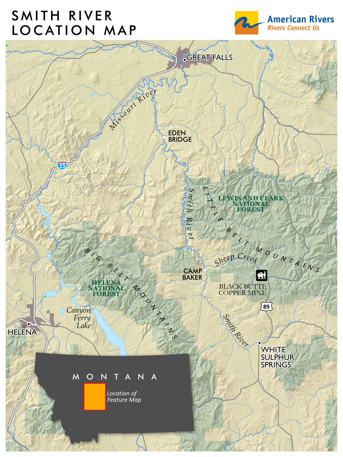
Scott Bosse, American Rivers’ Northern Rockies Director based in Bozeman, made the following statement:
“American Rivers joins thousands of Montanans in expressing our deep disappointment with this decision, which ignores the findings of top experts who concluded that the Black Butte Copper Mine poses a serious threat to Sheep Creek and the Smith River. Mining has its place in Montana, but not in the headwaters of one of our most beloved rivers. We intend to challenge this decision.”
American Rivers listed the Smith River in our America’s Most Endangered Rivers® reports in 2015, 2016 and 2018 due to the threats posed by the Black Butte Copper Mine. Those threats include dewatering vital trout spawning tributaries and polluting Sheep Creek and the Smith River with toxic heavy metals and acid mine drainage, which lasts in perpetuity. The Black Butte Copper Mine is being proposed by Sandfire Resources America, which is controlled by Perth, Australia based Sandfire Resources.
###
Upthegrove votes to save one of America’s Most Endangered Rivers
March 10, 2020
Contact: Brandon Parsons (512) 517-4001
Seattle – American Rivers today praised the King County Flood Control District and Council Member Dave Upthegrove for voting to approve a forward-thinking vision to safeguard communities from flooding while simultaneously supporting other community needs including salmon and orca recovery in the Green-Duwamish River.
The adoption of a supplemental budget today solidifies this vision by doubling investments in salmon recovery, prioritizing multiple benefit projects and creating new grant programs to support urban streams, coastal erosion, and barriers to fish passage throughout all parts of the county.
In April 2019, American Rivers named the Green-Duwamish among America’s Most Endangered Rivers because of the threat that outdated flood management poses to salmon, wildlife and communities. In January, Council Member Upthegrove was appointed Chair of the Flood Control District, and pledged to oversee major reforms at the Flood Control District that are critical to saving the Green-Duwamish.
Reforms are intended to accomplish two fundamental goals:
- Strengthen the District’s commitment to habitat, salmon and Orca recovery, and other environmental benefits.
- Provide more opportunities for areas outside of major river corridors to benefit from the work of the district.
The District’s new budget contains critical funding priorities, including:
- Double funding for salmon recovery – from $4.8M to $9.6M.
- Providing new ongoing funding to address urban streams, barriers to fish passage and coastal erosion throughout all parts of the County.
Funding two immediate projects that provide essential fish habitat and enhanced flood protection.
More than $163 million has been invested to restore salmon habitat in the Green-Duwamish alone and over $1 billion will be invested in the Duwamish clean-up, fish passage at Howard Hanson Dam, and Lower Green River Corridor Flood Hazard Management Plan over the next 50 years. King County has committed to invest an additional $6 billion in the next decade to unify efforts to protect clean water and habitat throughout the region. Aligning the Flood Control District’s work with these existing programs is essential to tackling King County’s most complex environmental problems and is a smart use of taxpayer dollars.
Wendy McDermott, Director of the Puget Sound and Columbia River Basins at American Rivers, made the following statement:
“This is a major step forward for this endangered river, and it’s the kind of vision that could make the King County Flood Control District a national leader in innovative flood protection efforts. With river health at risk, salmon runs struggling and climate change adding new challenges, we must increase investments in salmon recovery and embrace multi-benefit flood protection solutions that restore habitat and protect water quality. We applaud Councilman Upthegrove for committing to these worthy goals.”
Read about the Green-Duwamish listing in America’s Most Endangered Rivers of 2019: https://endangeredrivers.americanrivers.org/green-duwamish-river/
Northwest needs new thinking, collaborative solutions
February 25, 2020
Contact: Amy Kober, 503-708-1145
Portland – This Friday, the U.S. Army Corps of Engineers, U.S. Bureau of Reclamation, and Bonneville Power Administration will release a draft environmental impact statement addressing the latest plan for operations of the hydropower dams on the Columbia and Snake rivers. Five plans have failed already, rejected by courts as illegal and inadequate for saving endangered salmon, and the same fate likely awaits this one.
Wendy McDermott with American Rivers released the following statement:
“Salmon-dependent communities across the Pacific Northwest feel like Bill Murray in Groundhog Day, reliving the same day over and over again. Here in the Northwest, we’re looking at yet another Snake River salmon recovery plan that will almost certainly fail and is unlikely to survive legal challenge. We’ve been at this for more than 20 years. With salmon facing extinction, isn’t it time for new solutions?”
“You can’t solve a problem if you are not analyzing the right questions to begin with. This environmental impact statement was never designed to address the complex challenges facing our region. It will not provide a comprehensive solution for our salmon, energy and agriculture needs, nor will it address how the federal government will uphold its obligation to Columbia River treaty tribes. But that’s the conversation that communities that depend on the benefits the Columbia and Snake Rivers are ready to have.”
We need to think bigger and more holistically. The region’s governors are spurring important dialogue about how we might reimagine our relationship with the Columbia and Snake rivers and ensure a future of abundant salmon, clean affordable energy and thriving agriculture. Key members of the Northwest Congressional delegation, who ultimately will need to craft a comprehensive legislative solution, are also supporting constructive conversations. We must keep these conversations going with an eye to inclusive solutions that move everyone forward together.”
“We share common values, and we can work together to address everyone’s needs. That’s why farmers are speaking up for salmon recovery. Fishermen are supporting upgrades to grain transportation. Businesses want investments in clean energy. We must focus on what connects us and commit to meeting the region’s energy, agricultural and conservation challenges together.”
February 16, 2020
Contact: Amy Kober, 503-708-1145
Portland — Oregon has a distinguished reputation as a leader in protecting and restoring healthy rivers and wild salmon, and Governor Kate Brown continues to uphold and strengthen this legacy. Her February 11 letter to Washington Governor Jay Inslee demonstrates her strong commitment to recovering healthy, harvestable wild salmon in the Columbia-Snake rivers to benefit endangered Southern Resident orcas, and her leadership toward an inclusive regional solution that prioritizes clean, affordable energy and investments in agriculture and transportation infrastructure.
Wendy McDermott, Northwest Director for American Rivers made the following statement:
“Governor Brown is standing up for all of Oregon’s businesses, families and rural communities that depend on healthy, harvestable salmon runs. Her leadership has made Oregon a linchpin in achieving a comprehensive, lasting solution on the Columbia-Snake and for all of the communities that depend on these rivers.”
“Big, bold thinking has always defined our region. We need to tap into this same spirit to build the Pacific Northwest of the future with clean, affordable energy, thriving agriculture and abundant salmon. Governor Brown, Governor Inslee and our other Northwest leaders are vital to achieving this vision.”
###
February 13, 2020
Contact: Amy Kober, 503-708-1145
The U.S. House of Representatives yesterday voted to protect more than 1,000 miles of rivers with Wild and Scenic River designations. The public lands legislation, Protecting America’s Wilderness Act (H.R. 2546), includes Wild and Scenic safeguards for rivers including the San Gabriel and important portions of the Trinity River watershed in California and the Queets, Sol Duc, and Elwha in Washington.
Bob Irvin, President and CEO of American Rivers, made the following statement:
“Clean, free-flowing rivers are vital for our drinking water supplies, strong local economies and a vibrant outdoor recreation industry. We applaud the House for its action, and thank Representative Huffman (CA-2), Representative Judy Chu (CA-27), Representative Carbajal (CA-24), and Representative Derek Kilmer (WA-6) for their leadership. We look forward to seeing the U.S. Senate take up these bills to protect outstanding rivers.”
“Protecting Wild and Scenic Rivers is an investment in our communities and our future. Every mile protected means cleaner water, more abundant wildlife, and more opportunities for people to connect with the outdoors.”
###