This past week President Biden unveiled his American Jobs Plan, proposing a nearly $2.3 trillion investment in our national infrastructure. A game-changing investment of this size in modernizing our infrastructure and fighting the effects of climate change is a necessary step, but the question remains, does this bold plan do enough for rivers?
Last year we wrote the Rivers as Economic Engines report, which identifies a $500 billion need over the next 10 years in order to properly support for our waters. This includes investing $200 billion for improving water infrastructure, $200 billion for modernizing flood managements, and $100 billion for restoring watersheds in our community. President Biden exemplifies his own commitment to our nation’s water resources through his American Jobs Plan, which includes $111 billion to revitalize our nation’s antiquated water systems.
“Too many American families drink polluted water, lack access to affordable, high-speed internet, or experience power outages too often – all while paying more for those services. President Biden’s plan invests in the infrastructure necessary to finally deliver the water, broadband, and electricity service that Americans deserve.”
In an effort to remediate lead exposure in homes, schools and childcare facilities, President Biden aims to eliminate lead pipes and service lines completely by investing $45 billion in the Environmental Protection Agency’s Drinking Water State Revolving Fund and in Water Infrastructure Improvements for the Nation Act (WIIN) grants. To address the myriad of other issues facing our aging water systems, President Biden will modernize these systems by investing $56 billion in grants and low-cost flexible loans to states, Tribes, territories, and disadvantaged communities across the country. President Biden plans to stymie our nation’s most concerning emerging contaminants by allocating $10 billion to remediate and monitor PFAS in drinking water, and to invest in rural and small water systems.
“President Biden’s plan will protect and, where necessary, restore nature-based infrastructure – our lands, forests, wetlands, watersheds, and coastal and ocean resources. Families and businesses throughout the United States rely on this infrastructure for their lives and livelihoods.”
The American Jobs Plan maximizes the resilience of land and water resources by directing Congress to invest in protecting communities by building coastal resilience to sea-level rise and hurricanes. Congress is also directed to invest in the protection and restoration of major land and water resources like Florida’s Everglades National Park and the Great Lakes. In addition, President Biden takes aim at the western drought crisis by investing in water efficiency and recycling programs, Tribal Water Settlements, and dam safety.
American Rivers applauds President Biden’s commitment to restoring watersheds, providing clean water, modernizing water infrastructure, and addressing water scarcity. The American Jobs Plan has the opportunity to re-energize our country and refocus our needs towards our most vital resource, water.
While this is a good start, it will not get us across the finish line. To finish the fight, American Rivers calls for investments of an additional $200 billion for improving water infrastructure, $200 billion for modernizing flood management, and $100 billion for restoring watersheds in our communities. With these added investments, we feel we move closer to a future of clean water and healthy rivers everywhere, for everyone.
Most fly fishermen are familiar with the Battenkill in Vermont and NY as an iconic trout stream in American fishing. The Orvis Company headquarters are located along it, and they named one of their most popular reels after it. Renowned fly fishing author John Merwin called it “my favorite place,” and John Atherton said it was “the most difficult of rivers and yet the most rewarding in the things which count the most.”
Having fished it earlier this year on a trip to the American Museum of Fly Fishing in Manchester, VT, I had a chance to see first-hand what a beautiful stream it is, and how much fun it is to bring its fine trout to hand.
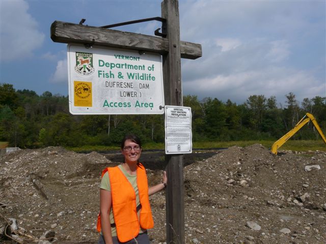
Amy Singler at Dufresne Dam Removal, Battenkill River, VT | Amy Singler
While there in Manchester, I also had a chance to visit the Dufrense Dam which had blocked the river there in Manchester for over 100 years, creating a pond that was so full of silt that there was actually a silt island in the middle of it.
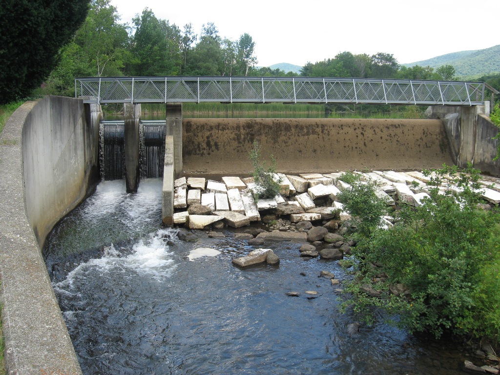
The dam, like so many built in New England at that time, originally provided power for a nearby mill. It hasn’t served that purpose since the ‘40s, so for all of those years since, it has done what dams do to trout streams: block fish access to historic spawning grounds, inhibit seasonal movements up and down stream, warm the water above its natural temperature, reduce oxygen levels, and hold back nutrients from the downstream sections…all of which are bad news for the wild trout.
It was a significant structure: 12 feet high and over 250 feet across. I’m glad to say “was”, because in early September the dam was removed by a partnership between the Vermont Department of Environmental Conservation, the Vermont Fish & Wildlife Department, U.S. Fish and Wildlife Service, and American Rivers, as noted on the Vermont.gov website.
Amy Singler, our dam removal specialist for this project, said, “Having helped with the early survey work in the impoundment, it is fantastic to see the river return and know the impact it will have for river habitat up and downstream.”
Before photo from of the Dufrense Dam. | Amy Singler
This dam removal is a good example of the kind or work we do, such as assisting with initial concept design, technical consulting, surveying, and in some cases project management, obtaining permits, performing fundraising, and submitting grant proposals.
The wonderful result of this work with our partners is that the Battenkill’s wild brown and brook trout will now have access to another six miles of spawning habitat on the Battenkill, not counting additional tributaries, and improved habitat in terms of oxygen levels and water temperature…all of which is great news for the trout.
Thinking back to when I first saw the dam and the impoundment, I had said to Brian Graber, the national leader of our dam removal program, that it was hard to believe that the shallow, unattractive, silted pond was the same body of water as the beautiful trout stream downriver. His reply was, “It will all be beautiful soon.” I’m sure he’s right about that.
The locals and state officials are hopeful that the positive impacts on wild trout will make it an even better fishery, which is great to hear. And for all of us anglers across the country, we can take heart that another iconic American river has been restored.
Today’s guest blog about the #7 Black Warrior River- a part of our America’s Most Endangered Rivers® series- is from Reverend Anthony “Alann” Johnson, MDiv, the President of Birmingham’s Titusville Community. On May 18, the Titusville Community passed a resolution opposing the Shepherd Bend Mine [PDF] that has been proposed on property predominantly belonging to the University of Alabama.
In the famous 1979 movie starring Al Pacino, And Justice for All, Pacino plays Arthur Kirkland, an idealistic defense attorney who believes that “justice” truly belongs to everyone. Director Norman Jewison’s creative skill should be lauded for titling his movie after an excerpt from the United States Pledge of Allegiance. This powerful phrase, “And justice for all…,” perfectly summarizes the catalyst and/or impetus of the civil rights movement. It also defines our struggle to-date for civil and human rights.
However, civil rights wouldn’t mean anything if we didn’t have people to enjoy them. Human beings consume air, water, and food each and every day. For these reasons, I am even more passionate and vehement about our continued struggle for environmentalism.
Here in Birmingham, Alabama, we are enjoying the 50th Anniversary of our exodus from the archaic and primordial ways of thinking (racism) in 1963, and we are celebrating the great leaps, bounds, and strides that we have made as people. However, the pending question is: Where do we go from here?
The world used Birmingham as a model, and now the world is a better place because of not only what happened in Birmingham in the past, but what is happening today in Birmingham. We live together. We work together. We play together. We worship together. We celebrate good news together. We mourn tragedies together. Birmingham is a melting pot of many different cultures, nationalities, creeds, races, religions, cultural beliefs, and professional and economic backgrounds.
We must continue to have the courage to face the modern day Goliaths who want to pollute our environment. Perhaps the most prominent current example is Drummond Company, which is proposing the Shepherd Bend Mine on what is mostly University of Alabama property along the Black Warrior River’s Mulberry Fork– right where 200,000 residents of the Birmingham area get their drinking water.
Clean water is undeniably a civil and human right.
All of my white, black, yellow, brown, and red brothers and sisters are divinely and indelibly linked by the color of “green” locally and around the world. Those who are sympathetic and empathetic to the cause of protecting God’s green and blue Earth, and ensuring that our children’s children are guaranteed the unalienable rights of life, liberty, and the pursuit of happiness, must speak up. I ask that concerned citizens everywhere, of all backgrounds, urge the University of Alabama System’s Trustees to promise that they will never lease or sell their land and minerals for mining at Shepherd Bend.
This is a guest post from Richard Leo from the Coalition for Susitna Dam Alternatives
The biggest dam in America since Glen Canyon. The eighth tallest in the world when fully built. On a great wild river of dense salmon runs in the Mt. McKinley heart of Alaska. Right next to a major active earthquake fault, too.
Yup, it’s as alarming as it sounds. But the State of Alaska has already appropriated the initial funding to dam the Susitna River because Alaska needs the electricity.
Except… Alaska Doesn’t
Natural gas now powers most of the region the Susitna Dam would serve. There’s enough natural gas in those fields for at least a hundred more years. Alaska holds 90% of America’s potential for tidal power with generator tests happening now. Geothermal development is already in progress because Alaska’s geothermal potential rivals Iceland’s. Alaska’s first two wind farms that will be ready next year have the capacity for a quarter of the Susitna Dam’s output.
The Susitna Dam would produce 280-300 megawatts (Mw). The Grand Coulee on Washington’s Columbia River produces 3,000. A basic energy efficiency program for the same population base as the Susitna Dam’s electricity could save 200-300 Mw.
The free-flowing Susitna River descends from the glaciers of North America’s highest mountains. A $5-10 billion dollar wall of concrete simply doesn’t belong in the center of Alaska’s iconic wilderness landscape, where visitors from around the world come to experience natural grandeur.
Choking this wild river with a massive and unnecessary dam is an assault on our nation’s natural heritage.
Learn more about the Susitna River and the effort to stop the dam at SusitnaDamAlternatives.org
Updated October 6, 2011
We had such a response on this post that we wanted to update this post to address the comments that came in. Hope these help clear up some confusion:
Geothermal is not viable in the Matsu area and it never will be. it might be in “development” in the state somewhere but I can assure you it is many many miles from this market and any development is small scale and tens of years away.
The Alaska Energy Authority, the agency responsible for building the Susitna Dam, has helped fund a large geothermal development on Mt. Spurr. The project would serve the same area as the Susitna Dam (in face, Mt. Spurr is within sight of the Susitna River, directly across Cook Inlet from Anchorage). That project is expected to be online in ten years (the Susitna Dam’s earliest completion would be 12 years) with a potential for 100 MW. See report.
Wind power is not a consistent source of power and also needs tens of years of development before any production starts.
The first two large Alaska wind farms are scheduled to begin generating electricity by the fall of 2012.
The natural gas reserves are not going to last long and are not going to fuel any expansion of the existing market.
Alaska holds enough natural gas reserves for many many hundreds of years. There are currently three major natural gas projects actively being considered: 1) by large-diameter pipeline from the enormous reserves on the North Slope through Canada to the Lower 48 with branches into the area the Susitna Dam would serve; 2) a smaller-diameter pipeline from the North Slope directly to the area the dam would serve; 3) expanding the existing fields in Cook Inlet where a June, 2011 survey by the USGS showed that Cook Inlet reserves are not 1 but 20 trillion cubic feet. 75% of the area that dam would power now receives its electricity from Cook Inlet natural gas fields. Yes, existing Cook Inlet wells are beginning to run out, but not the field.
The proposed dam would be 700′ (213 meters) tall. This would make it the 30th tallest dam on earth. Not the eighth.
According to the Alaska Energy Authority, one of the design options currently being considered for the dam on the Susitna would allow it to be “expandable” to 885 feet in height, or 269.7 meters (see p. 10 of PDF). This would make it the 5th tallest dam on earth and the tallest dam in the United States. The relatively small amount of electricity the Susitna Dam would produce would indicate that the developing the dam to its full height may be necessary to achieve the greatest amount of power for the cost.
There are “dense” salmon runs on the Susitna River. However, the proposed dam will be on a tributary of the river. Only 17% of the river flow is impacted by the dam. The dam site will be 15 miles upstream of Devils Canyon, The turbulent waters of the Devil’s Canyon rapids downstream of the dam site provide a natural barrier to upstream migration of salmon.
The dam will not be on a tributary, but on the Susitna River itself. And a dam’s impacts on fisheries are not limited to the blocking of spawning grounds. According to studies done by the State of Alaska, the natural mineral toxicity of the Susitna River is sufficiently high to be at a threshold for salmon viability. Blasting apart the rock from which those elemental magnesium, aluminum, iron, and other salmon toxins come could impact salmon runs all the way to the mouth of the river. Additionally, according to the State’s own studies, the water temperature of the Susitna River is at the upper limits for salmon. The dam will discharge warmer water than occurs naturally, causing further harm to the sustainability of these commercially valuable fish.
Finally, at least two species of salmon, king and sockeye, are known to spawn far above Devil’s Canyon, a tribute to the marvel of the wild salmon. State fisheries biologists, in their off-time, anecdotally report sightings of hundreds of sockeye in the Susitna drainage waters above Devil’s Canyon.
The Susitna dam project would be a 600 MW project – not a 200 to 300 MW.
The “installed capacity” of the Susitna dam would be 600 MW. But “installed capacity” is a very misleading number, and it isn’t the same thing as actual generation. Instead it’s the maximum generation that’s possible when the dam is running full throttle, a bit like 120mph on my car’s speedometer. Most dams generate much less than their installed capacity in actual use. According to The Alaska Energy Authority, the dam’s average annual output would be 2,600 GW hours, or 296.8 average MW, a little less than half of its installed capacity. By way of comparison, the Grand Coulee Dam’s average annual output [PDF] is 22,600 GW hours, or 2,580 average MW.
The 1900 acre easement protects a significant section of the Wateree River near the Congaree National Park as well as 800 upland acres from development. The Congaree Land Trust’s COWASEE Basin Initiative prioritizes private land protection along the Congaree, Wateree, and Santee Rivers. The COWASEE Basin initiative was started five years ago with the goal of protecting 215,000 acres adjacent to the three rivers. To date, nearly a third of 215,000 acres is protected from development. To read more about their recent conservation easement check out the great article in The State.
Next time you are paddling the Congaree or Wateree River Blue Trails it will be nice to know that people are working hard to protect the wild nature of these rivers for generations to come.
On February 23, the Kershaw County Council voted unanimously to pass a new package of zoning and land development regulations. An ordinance is included in the package that will protect all rivers and streams by requiring a 100-foot strip of trees and plants along the riverbank to limit the amount of polluted runoff that flows into the county’s waters.
American Rivers has worked closely with planners and others in the county to develop the Wateree River Blue Trail, the water equivalent of a hiking trail, in an effort to reconnect communities to the recreational, economic, and cultural values of the Wateree River and to protect the river’s clean water. The county’s new river safeguards are an important part of the effort to ensure the Wateree remains one of the area’s most valuable assets.
Matt Rice, associate director for conservation in the Southeast office of American Rivers, made the following statement:
“We applaud Kershaw County for recognizing that healthy rivers mean a healthy community. The council understands that protecting rivers and clean water now will save taxpayer costs for water treatment in the future.”
“Protecting natural areas along county rivers and streams is a cost-effective way to safeguard clean water and wildlife, and ensure that Kershaw County remains an outstanding destination for families, paddlers, and anglers.”
“Kershaw County’s safeguards are a model for other counties in South Carolina and nationwide. Other communities looking to promote clean water and public health, and save taxpayer dollars at the same time, would be wise to follow Kershaw County’s lead.”