Originally published on Chaco Blog.
We name them after colors: Red, Vermilion, Colorado. Green and White and Black. Bluestone and Yellowstone. We name them after weather: Hurricane, Wind. After size: Little, Rio Grande. After animals: Wolf, Bear, Salmon, Eagle. We call them by their currents: Roaring, Rapid, Rogue. Clearwater, Crescent, Crooked. Sandy, Salt, Sweetwater.
We call them veins, capillaries, arteries. We call them highways, ribbons, lifelines.
Some cultures call them Mother.
Depending on where you live, you might say brook or creek or run. You might say arroyo or stream or wash.
We all say River. They connect us. They run through us.
Our bodies are roughly 60 percent water. Newborn babies are 78 percent. Is it any wonder we are drawn to rivers, is it any wonder we want to return to them again and again?
What do you love about rivers?
Is it the escape into river time when you step into your sandals or grip the oars? Is it the intoxicating smell of sage and red rock in the hot sun? Is it the exhilaration of the rapids or floating in quiet water just gazing up at the sky? Do you love the canyon wrens and kingfishers and ravens smart enough to open your dry bag clips? Is it the red vine maples on the Elwha, the mountain laurel on the Youghiogheny, or maybe feasting from the old cherry tree on the Salmon? Is it rope swings or fly rods or super soakers or skipping stones?
Which river has your heart? Is it a wild one like the Selway? A desert river like the Yampa, or a lush river like the Sol Duc or Congaree? Maybe it’s a river right out your back door like the Charles, the Potomac, the Willamette?
We have a million reasons to love rivers and we know you do, too. This Earth Day, write a love letter to your river. Because sharing the love is one of the best ways to make sure it will keep running and flowing and loving you back.
#WeAreRivers
As I concluded my second week on staff at American Rivers, floating down the upper Flint River in a kayak with Joe Cook, the Coosa Riverkeeper, I couldn’t help but reflect on the meandering path that brought me here. It was almost exactly 10 years ago that I took my first paddling trip, long before I even considered the possibility of becoming a ‘water guy’. Most of the time, we don’t recognize the events that define us until long after they’ve past. As I set out to get acquainted with the river I’ll be working to restore and protect, I couldn’t help but conjure feelings of a blind date. Would it be love at first sight?
Being new to American Rivers, and to Georgia, I’ve found myself with a lot to learn. I’ve already spent countless hours reading everything I can about the Flint River and water management in Metro Atlanta. Beyond that, I’ve spent years learning about the state of water around the world through work and study. Now it’s time to take everything I know, combine it with who I am, and turn it into some kind of momentum that will evoke positive change for people and the rivers.
In two weeks, not only have I been adopted by a family of inspired, passionate, motivated, and fun people, I’ve also been responsible for creating highly relevant and useful products. I provided advice to seven municipalities on how to restructure their codes and ordinances to ‘unpave’ the way for green infrastructure (turns out blowing up parking lots isn’t a thing yet, but we’re working on it). I’m also working up material on maximizing water efficiency efforts before building new dams and reservoirs. I’ve attended conferences and working group meetings, met amazing people, read so many fascinating reports (seriously), and above all else, I’m a part of integrated water management in action. Could a water guy ask for more?
I was fortunate to float the high waters of spring on the Flint; I saw the river overflowing its banks and gurgling through the often intact and healthy floodplain. Deer, beavers, turtles, fish, birds, budding flowers, massive trees, and (perhaps most importantly) rope swings were everywhere. It’s hard to imagine such a beautiful place Running Dry, but Atlanta is thirsty, the earth is increasingly impermeable, crops need water, and droughts happen. Most of us have emotional connections to the rivers and streams with which we’ve grown up. Mine are mostly in North Carolina: the French Broad, the Haw, the Big Ivy, and the Neuse to name a few. So, the question remains. After finally meeting the Flint River, was it love at first sight? We still have a lot to learn about each other, but we’re off to a great start, and I can’t wait to spend more time with her.
In 2015, we will complete five meadow restoration projects with our partners in five watersheds. This on-the-ground work is part of our conservation strategy that uses pilot projects to build momentum, galvanize partnerships, demonstrate early successes, and ultimately create a fertile framework to accelerate restoration. We have seen time and again how projects can be used to build the technical and collaborative capacity needed to get more done.
We have worked on meadow restoration with seven out of the 10 National Forests in the Sierra and seen exponential growth as a result of building capacity with pilot projects. For example, in the Walker River watershed, one pilot project and the formation of an associated Walker working group has led to five more projects under development. And in the Mokelumne Watershed one project has led to two more that are being pursued by the project team and other collaborators.
The increased capacity for meadow restoration is in high demand. The California drought and Proposition 1 have increased attention on multi-benefit water storage projects in headwaters regions and in floodplains, and the Governor’s Water Action Plan calls for 10,000 acres of meadows to be restored within five years. However, the early phases of a project, including project identification, design and permitting, currently act as a bottleneck to project development due to a lack of experience and expertise. As a result, funding for construction is outpacing the supply of projects, and there are virtually no shovel-ready meadow restoration projects to invest in. This is where AR has played a key role in the 5 projects pictured. During the early stages of projects, AR leads partners in developing a list of priority meadows and supplies appropriate funding and expertise to launch a first effort off the ground. Successes in fundraising, monitoring, and implementation establish a core group of partners and the second and third efforts are always easier.
This summer we will also partner with the US Forest Service and National Fish and Wildlife Foundation to develop a meadow restoration training and mentoring program for USFS and other agency staff. We will gather lessons learned into a handbook, enable practitioners to gain on-the-ground experience and team them with a mentor for future project implementation. Our goal is to work ourselves out of a job and to use the relationships we have built to launch us into other headwaters issues, and we’ve made great progress toward this goal. The agencies have begun to set strong meadow restoration targets, we have helped develop robust funding streams to support meadow restoration, and we anticipate the training program will build the capacity of land managers and local conservation groups to partner and satisfy the growing call for meadow restoration.
Recently, Gov. Jerry Brown and the Legislature announced a $1.1 billion drought relief plan for California. But the $660 million allocated for flood management had many observers scratching their heads. We believe that this money could actually enhance water supply, but only if we rethink the flood system.
The governor is absolutely right to be thinking ahead about floods. The epic 10-year Australian drought ended with the two biggest flood years on record. Climate-change predictions of more frequent “pineapple express” storms underscore this threat to California.
But what does this have to do with drought?
Nothing, if the $660 million is spent on traditional flood control projects to harden riverbanks with rock and raise levees. These 19th century-inspired projects are not only bad for the environment, but in too many cases they actually increase flood risk and degrade water quality by encouraging development in floodplains. They also starve salmon and other fish that once grew big on the river’s natural floodplain. It’s no wonder that some of these fish are hovering on the brink of extinction.
California’s flood management system was conceived more than 150 years ago for a very different state and climate. The levees were originally located close to the riverbank to flush Gold Rush mining debris out of clogged channels and to ease the way for riverboats. Now, we are forced to manage Central Valley water resources within the constraints of more than 1,000 miles of aging, poorly engineered levees designed for antiquated purposes.
With the governor’s leadership, however, California is now poised to invest in a new kind of flood management that will protect public safety, prepare the state for future droughts, restore salmon runs and even provide new opportunities for public recreation.
The key concept is “multi-benefit flood management projects.” A typical one would set a levee back from the river’s edge, or widen a bypass to allow high water to spread out on the adjacent floodplain.
Perhaps the best local examples are proposals to expand the Yolo and Sacramento bypasses and to set back levees along the Sacramento River in West Sacramento. Both projects expand areas that can be safely flooded while creating critically needed habitat and recreational opportunities. We know of many other similar “shovel-ready” projects.
This approach is clearly good for flood protection because it steers dangerous waters away from cities and relieves the pressure on aging levees. It’s also good for salmon and waterfowl.
It also increases the water supply. Widening floodplains increases floodwater retention and replenishes underground aquifers, particularly important in the San Joaquin Valley where groundwater levels are plummeting. Capturing floodwater during wet years to recharge depleted aquifers, as nature once did, is one of the best tools we have to ensure adequate groundwater reserves during droughts.
Expanding floodplains also allows more water storage in our reservoirs. Now, flood managers must keep a portion of our extensive reservoir system empty to capture storm flows. In late 2012, only months before the driest calendar year on record, managers were forced to release hundreds of thousands of acre-feet of water to maintain a “flood reservation” behind large dams. More downstream floodplains would allow dam operators to retain more water behind the dams, resulting in more water for our use.
Certainly, some levee work is still needed to protect vulnerable urban areas, such as finishing the levees ringing Natomas and improving levees adjoining Land Park and the Pocket. But the old levee system is inefficient and outdated.
We need to modernize our infrastructure and our thinking. One very good way is by investing bond money in multi-benefit flood projects that create more water supplies and habitat while improving flood safety.
Guest post by Roger Clark
Being named America’s Most Endangered River is a dubious honor. First place in rivers under siege is the last place we want the mighty waters that cut Grand Canyon to be. So when American Rivers asked Grand Canyon Trust to be its local partner in designating Grand Canyon’s reach of the Colorado River the Most Endangered River in America, we jumped at the chance to spotlight the clear and present dangers to the canyon’s precious waters and what we’re doing to stop them.
Among the most serious threats to Grand Canyon’s waterways are uranium mines and commercial developments.
Uranium Mining
Uranium mining started along Grand Canyon tributaries in the 1950s. Dozens of mines were opened and closed within the Kanab Creek watershed, and seepage from Orphan Mine on the South Rim has been polluting Horn Creek for more than two decades.The National Park Service advises hikers not to drink even filtered water from these two creeks and several others where harmful levels of radionuclides are being measured.
In 2010, water samples taken by the U.S. Geological Survey identified more contaminated sites “related to mining processes.” They found 15 springs and five wells that contained dissolved uranium concentrations in excess of the Environmental Protection Agency’s standards for safe drinking water.
In 2012, the Secretary of the Interior issued a 20-year ban on new uranium claims on one-million acres of public lands adjacent to Grand Canyon National Park. His decision was the direct result of a multi-year campaign by Havasupai leaders, conservationists, and a coalition including water districts, ranchers, Arizona’s state wildlife agency, sportsmen, business leaders, and elected officials.
However, four preexisting uranium mines continue to pollute water within the withdrawal area. Records show, for example, that highly contaminated groundwater (80 times the limit set to protect public health and the environment) is being pumped from Pinenut uranium mine immediately north of Grand Canyon National Park. The Grand Canyon Trust and allies are pressuring agencies to require aquifer monitoring and other compliance measures to reduce risks of pollution from uranium mines that continue to operate.
Commercial Developments
In 2010, Scottsdale developers unveiled plans to build a billion dollar tourist resort on the east rim of the Grand Canyon, with a tramway to carry up to 10,000 visitors a day down to the confluence where the Colorado and Little Colorado rivers meet. The “Grand Canyon Escalade” and its associated access road and infrastructure would be built on land controlled by the Navajo Nation. Dozens of Navajo citizens who hold grazing leases within the proposed resort’s 420 acres footprint oppose the project. In 2012, this core group invited Grand Canyon Trust to become part of its Save the Confluence coalition and to join their fight to stop Escalade.
Ten thousand tram-riders a day will demand a highly effective sewage system. In addition to a 4,000 sq. ft. “restroom facility,” Escalade promoters plan to build food and beverage, retail, and other structures at the bottom of the Grand Canyon, just upriver from the Colorado’s confluence with the Little Colorado River. And yet Escalade’s proposed “master agreement” with the Navajo Nation does not include any sewage treatment facilities down by the rivers that host the last breeding area for the endangered humpback chub.
Escalade investors have spent several million dollars to convince the Navajo Nation’s president and 24-member council to approve the secretly negotiated master agreement and developer-written legislation. With support from the Navajo president, promoters predicted full approval by the Navajo Council by the end of 2014. But, due to strong opposition by local Navajo residents and the Save the Confluence coalition, they have failed to find a single sponsor to introduce supporting legislation.
While approval of Escalade is working its way through the Navajo legislative process, Save the Confluence is prepared to block any final approval. More than 30 families intend to file an injunction against the bill’s land transfer without their permission, as required under Navajo law. Hopi leaders, who voted unanimously against Escalade when it was first proposed, are poised to enforce an inter-tribal compact which prohibits development at the confluence without consent of both tribes. And the National Park Service stands ready to challenge the tram’s intrusion into its jurisdiction.
Grand Canyon Trust is pleased to join American Rivers in calling upon all citizens to fight against assaults on Grand Canyon’s sacred waters. The Most Endangered River announcement is a timely reminder that the entire Grand Canyon needs our enduring support to protect.
Roger Clark is the Director of the Grand Canyon program for the Flagstaff-based organization, Grand Canyon Trust.
It is such a thrill to complete a project! Especially a two and half year collaborative, planning project that involves several organizations, governments and individuals who have spent hundreds of hours in meetings, on field tours and site assessments, and researching and writing detailed information.
It gives me great pleasure to announce that the Upper Nooksack River Recreation Plan has been finalized and was released to the public today. This new, comprehensive plan will help guide the management of recreation and natural resources along the upper Nooksack River system in Washington state. The plan recognizes and supports the economic and health benefits of recreation, along with protection and restoration of the natural and cultural values of the upper river basin.
Nearly 600 individuals and organizations, including landowners, businesses, paddlers, anglers, hikers, skiers, and equestrians contributed to the Upper Nooksack River Recreation Plan’s development over the past two years, leading to the formulation of over 80 management recommendations. These recommendations are focused on the river corridors of the Nooksack’s North, Middle, and South forks and several tributary streams. Recommendations include improving access to the river, enhancing education and stewardship, maintaining roads and trailheads, and protecting the outstanding values of the river.
The Nooksack River is the lifeblood for local communities that rely on the river for clean water for drinking and agriculture, and for tourism income from visitors drawn to the river’s world class whitewater boating, hiking, skiing, horseback riding, fishing, mountain biking and other recreation opportunities. Outdoor recreation opportunities are important to quality of life as well as economic growth in Washington’s Whatcom and Skagit counties and across the state. For example, outdoor recreation trips and equipment contribute $21.6 billion annually to Washington’s economy, $8 billion of which is spent on activities around water, including fishing, boating, swimming and diving.
The recreation plan was developed through a collaborative planning process led by an advisory committee comprised of representatives from American Rivers, American Whitewater, Hydropower Reform Coalition, Mount Baker Club, National Park Service, Nooksack Tribe, Nooksack Salmon Enhancement Association, Pacific Northwest Trail Association, the United States Forest Service – Mt. Baker Ranger District, Whatcom Chapter of Back Country Horseman of Washington, Whatcom County Parks and Recreation Department, Whatcom Events (Ski to Sea Race), the Whatcom Land Trust, and Wild and Scenic River Tours. Planning assistance was provided by the National Park Service’s Rivers, Trails, and Conservation Assistance Program.
For more information about the recreation plan or to get involved, please contact me at wmcdermott(at)americanrivers(dot)org.
It’s one of the Seven Natural Wonders of the World, and an irreplaceable national treasure. It’s the Colorado River in the Grand Canyon, and it is the #1 Most Endangered River of 2015.
The river faces a battery of threats that could forever harm its health and the unique experience that belongs to every American. Not since dams were proposed in the 1960’s has the Grand Canyon faced such a serious attack.
[su_youtube url=”https://www.youtube.com/embed/P_KD0SBQ4YU” width=”1020″ height=”580″]
The massive Escalade construction project would irreversibly scar the fragile heart of the canyon with bulldozers, noise, and pollution. A tram from the rim to the confluence of the Little Colorado and Colorado Rivers, a hotel, restaurant, gift shop and riverside walkways would transform what has always been a wild place, sacred to many native tribes.
And that’s not all. Radioactive pollution from uranium mining threatens tributary streams of the Colorado River in the Grand Canyon. And, expansion of the town of Tusayan could deplete vital groundwater supplies, impacting the health of fragile desert ecosystems.
American Rivers and our partners at Grand Canyon Trust are calling on Secretary of the Interior Sally Jewell and the Obama Administration to use every authority to prevent damage to the river and preserve the Grand Canyon for all Americans to enjoy.
Please take action to preserve the Colorado River in the Grand Canyon for all of us, for all time.
The annual America’s Most Endangered Rivers® report is a list of rivers at a crossroads, where key decisions in the coming months will determine the rivers’ fates.
“This year’s report underscores the importance of healthy rivers to each and every American,” said Bob Irvin, President of American Rivers. “Whether it’s for clean drinking water, ample water supplies for farms and cities, abundant fish and wildlife, or iconic places vital to our heritage, we all have a stake in protecting our nation’s rivers.”
America’s Most Endangered Rivers® of 2015:
#1: Colorado River in the Grand Canyon, Arizona
Threat: Massive construction project, mining pollution, groundwater depletion
At Risk: An irreplaceable national treasure
Millions of Americans recognize the Grand Canyon as one of the most iconic landscapes on the planet. But this natural masterpiece of the Colorado River faces a battery of threats. A proposed industrial-scale construction project in the wild heart of the canyon, radioactive pollution from uranium mining, and a proposed expansion of groundwater pumping at Tusayan, all threaten the Grand Canyon’s wild nature and unique experience that belongs to every American. Unless the Department of the Interior acts to stop these threats, one of our nation’s greatest natural treasures will be scarred forever.
#2: Columbia River, Washington/Oregon
Threat: Outdated dam operations
At Risk: Healthy runs of salmon and other fisheries
The Columbia River is the lifeblood of the Pacific Northwest’s economy and environment. The river’s dams provide more than half the region’s electricity as well as flood control and irrigation, but they have also decimated the basin’s salmon and steelhead runs. As the Columbia River Treaty is renegotiated, the U.S. Department of State must put the importance of a healthy ecosystem on an equal footing with the benefits of hydropower and flood control. We can achieve this balance by releasing more water for salmon when they need it and providing fish passage beyond currently impassable dams. Since the last Treaty was negotiated a little over 50 years ago, this is an once-in-a-lifetime opportunity to do right by one of the nation’s most important rivers.
#3: Holston River, Tennessee
Threat: Toxic chemical pollution
At Risk: Drinking water supply, fish and wildlife, and recreational uses
The Holston River is rich in history and heritage, and today provides drinking water for tens of thousands of Tennessee residents, as well as water for industry, livestock, and recreation. However, the river and its communities are threatened by an army ammunition plant that has been contaminating water supplies with toxic chemical pollution for years. The U.S. Army and its Holston Army Ammunition Plant must immediately stop polluting the Holston River with harmful explosive chemicals.
#4: Smith River, Montana
Threat: Copper mining
At Risk: Water quality, nationally renowned wild trout fishery
The Smith River is one of the most cherished floating and fishing destinations in Montana. The river is home to a nationally-renowned wild trout fishery, and provides prime habitat for dozens of fish and wildlife species. The river is threatened by a huge proposed copper mine in its headwaters that could seriously degrade water quality with acid mine drainage and toxic heavy metals. The State of Montana should not permit the copper mine unless it can be designed in a way that eliminates any risk to the river’s water quality and habitat.
#5: Edisto River, South Carolina
Threat: Excessive water withdrawals
At Risk: Water supply, water quality, fish and wildlife habitat, recreation
The Edisto River is one of South Carolina’s most popular rivers for paddling, fishing, and outdoor fun. It’s also the state’s most heavily used river for irrigation, and excessive agricultural water withdrawals are threatening water quality and the water supplies of other users. While the state’s permitting process requires industrial and municipal water users to meet requirements to safeguard river health and clean water, large agribusinesses get a pass. The South Carolina House of Representatives must pass H.3564 this year to end this unfair exemption so that the Edisto, and all of the state’s rivers, can continue to provide sustainable water supplies for all, while supporting river health and recreation.
#6: Chuitna River, Alaska
Threat: Coal mining
At Risk: Native culture, wild salmon, and clean water
The Chuitna River supports Alaskan Native communities, wild salmon, abundant wildlife including moose, bear, and wolf, and excellent opportunities for hunting, fishing, and other recreation. PacRim Coal’s proposal to develop what would be Alaska’s largest open-pit coal strip mine at the Chuitna River’s headwaters poses an unacceptable threat to the economy and communities that rely on clean water and healthy salmon runs. Unless the U.S. Army Corps of Engineers denies the mine’s permit, this pristine wild river and its communities will be irreparably damaged.
#7: Rogue/Smith Rivers, Oregon/California
Threat: Strip mining
At Risk: Clean water, drinking water, wild salmon and steelhead runs, Wild and Scenic Rivers
The Wild and Scenic Illinois Rogue (OR) and Smith (OR and CA) rivers are known for their healthy salmon runs, world-renowned plant biodiversity, and outstanding recreation. However, proposed nickel mining in these rivers’ headwaters threatens their unique values. Immediate closure of the area to mining is the most effective way to help prevent the development of nickel strip mines from turning the pristine headwaters of the highest concentration of wild rivers in the country into an industrial mining zone. The U.S. Forest Service, Bureau of Land Management, and Department of Interior must withdraw this area from mining immediately to protect this wild treasure.
#8: St. Louis River, Minnesota
Threat: Copper-nickel sulfide mining
At Risk: Clean water and wildlife habitat
Minnesota’s Arrowhead region is known for its pure and abundant waters, deep forests, expansive wetlands, and recreational opportunities. However, a proposed copper-nickel sulfide mine at the headwaters of the St. Louis River, the region’s main artery, threatens drinking water, wildlife, and the treaty-protected hunting, fishing, and gathering rights of the Ojibwe people. It is critical that state and federal regulators deny permits for the mine plan because it does not sufficiently protect the St. Louis River and its communities.
#9: Harpeth River, Tennessee
Threat: Sewage pollution and water withdrawals
At Risk: Clean water, fish and wildlife, recreation
The Harpeth River is one of the few free-flowing rivers in Tennessee. It flows through one of the fastest growing regions in the country, but remains an oasis for local families, anglers, and paddlers. The river’s waters, fish and wildlife, and recreation values are threatened by sewage and water treatment plant expansions. Unless state officials require state-of-the-art technology to improve sewage treatment, the river will be overwhelmed by treated sewage pollution and public health could be compromised.
#10: Pearl River, Louisiana/Mississippi
Threat: New dam
At Risk: Healthy wetlands and wildlife habitat
The Pearl River runs through Central Mississippi and supports vital oyster reefs and marsh habitat in the Mississippi Sound. Coastal wetlands and commercial fisheries depend on the Pearl River’s flows. However, the river’s health has been compromised by the Barnett Dam north of Jackson, Mississippi. Now, a new dam has been proposed for the Pearl that would cause additional harm to river health, wetlands, and fish and wildlife habitat. The U.S. Army Corps of Engineers must reject this unnecessary and ecologically harmful new dam.
Last Thursday Governor Brown announced a farsighted $1 Billion dollar drought relief plan for California, but the $660 million allocated for flood management had many observers scratching their heads.
The Governor is absolutely right to be thinking ahead about flood: The epic ten-year Australian drought ended with the two biggest flood years on record. Below is a visual of what Californian’s need to prepare for:
[su_youtube url=”https://www.youtube.com/embed/vhatmWYkRNo” width=”1020″ height=”580″]
But if the $600 million is spent on traditional flood control projects to harden river banks and raise levees, it will do little or nothing to relieve the stresses of future droughts and floods. These projects are not only bad for the environment, but in too many cases they actually increase flood risk and degrade water quality by encouraging floodplain development.
With the Governor’s leadership, California is now poised to invest in a new kind of flood management, multi-benefit flood management projects, that will protect public safety and increase the state’s resiliency against future droughts.
California’s water and flood management system was built 50 – 150 years ago for a very different state and climate. The levees were built very close to the river in the latter half of the 19th century to flush Gold Rush mining debris out of clogged channels and facilitate navigation in the years before invention of the automobile. Fast forward 150 years and we are now forced to manage the Central Valley water system within the constraints of over 1,000 miles of aging and poorly engineered levees.
The 2012 Central Valley Flood Protection plan now calls for setting back levees and expanding floodways through a system of multi-benefit flood management projects that not only give rives more room to safely accommodate large floods, but they also improve water supply reliability, water quality, recreational opportunities, and habitat for fish and wildlife. The governor’s recent announcement is not only a down payment on a new flood management approach but also on a larger water management approach that better harnesses natural processes to meet human and environmental needs.
In particular, multi-benefit flood management projects provide many important water supply benefits.
- Water Retention and Usability: Widening floodways increases floodwater retention and groundwater recharge in a manner that could have significant water supply benefits. Floodplains capture peak flows and then release them back in a manner that provides benefits for both water diverters and ecological function. In some cases, floodplain restoration can significantly recharge depleted aquifers storing water in wet years for use in dry years.
- Reservoir Operations and Storage: Widening the regulatory floodway will ultimately create opportunities for changes in reservoir operations that will increase carryover storage from wet years to dry years. Currently, reservoir operators must keep a portion of the reservoir empty to capture dangerous floods. In late 2012, only months before the driest calendar year on record, reservoir operators were forced to release hundreds of thousands of acre feet of water to maintain the “flood reservation” behind large dams. Larger floodways would allow reservoir operators to safely release more water during large storms, allowing them to safely keep more water in the reservoir during all other periods.
- Reduce conflict between environmental and consumptive uses: Conflicts over the competing water demand for cities, agriculture, and sensitive species is one of California’s largest water management challenges. Multi-benefit flood management projects improve conditions for many sensitive species, and will thus reduce the probability that future water managers will need to choose between delivering drinking water or protecting species from extinction during future droughts.
- Reduce water demand by riparian and senior water rights holders: Widening regulatory floodways often results in the acquisition of riparian lands and water rights that can be retired in all years or fallowed in dry years. Agricultural production is still possible in a periodically inundated floodplain, but acquisition of floodplain lands creates the opportunity to fallow or retire senior and riparian water rights on floodplain lands, at least in dry years.
- Improve water quality: Irrigation and drainage of levee “protected” floodplains degrades water quality for drinking water and the environment. Restoration of floodplains and natural flooding patterns reduces both the need to divert high quality water for irrigation and the drainage related discharge of poor quality irrigation return water. In addition, restored floodplain wetlands filter and cleanse polluted waters associated with drainage from agricultural and urban lands.
Since the 1950s, the US Army Corps of Engineers has been trying to build a levee near New Madrid, MO to halt seasonal backwater flooding and promote agriculture production within the lower portion of the New Madrid Floodway. The levee would prevent the Mississippi River from reaching 75,000 acres of backwater habitat, which during the regular biennial high water events floods about 33,400 acres – about the size of Washington, DC. The wetlands in this region not only support unique species, especially during seasonal floods, but during the large flood events is an essential reproduction area for many Mississippi River fishes.
American Rivers has asked the Environmental Protection Agency to veto the project because most experts agree that the wetlands and habitat loses would be un-mitigatable. And the Final Independent External Peer Review Report for the project supports our claims.
External peer reviews of Corps projects are called for when a project is controversial or exceptionally large. During the peer review, the Corps contracts with experts through a third party to review the materials and resources used by the Corps in their decision-making process. The panel charged with reviewing the New Madrid Levee Project found several flaws in the Corps resources and decision-making, including:
- The assumptions used in the economic analysis could not be justified, e.g. the Corps claims that the main benefit for the project is an increase in agriculture producer profits, but they provided little information to justify or quantify these claims.
- The economic analysis did not take into account the changes in environmental amenities associated with the project, like revenues from recreation.
- The wetland loss was underestimated, and the wetland mitigation plan “downplays the importance of ecosystems.”
- The data used in the environmental model is out of date and insufficient for evaluating the impact of the full range of species in the ecosystem.
- The expected impacts from climate change were not considered in projecting future crop yields.
- The Corps incorrectly assumes “that wildlife can relocate if habitat is lost.”
- The Corps suggests throughout the working final environmental impact statement “that there is little to no value associated with river connectivity or flood pulse for environmental resources.”
The report is clear: the Corps’ plan to build a levee across the last natural floodplain in the region is significantly flawed. Next we wait for the final environmental impact statement – which will reveal the Corps’ final decision to move forward with the levee project or abandon it forever.
The Upper St Anthony Falls Lock closure is inspiring a lot of imagination as citizens, planners, and non-profits try to dream up a new Minneapolis riverfront. Some of the ideas were voiced at a visioning meeting in Minneapolis a few weeks ago at Mill City. My personal favorite vision: Restoring the Mississippi River Gorge.
Historically, St. Anthony Falls was the head of a six mile stretch of rapids that was a rich spawning ground for native fish capped by a 50 foot waterfall that served as a natural barrier to northern migrating fish. But parts of the rapids were flooded when the Ford Dam (Lock and Dam 1) was constructed in the early 1900s, making St. Paul the head of Mississippi River navigation. And, jealous of St. Paul’s river navigation prowess, Minneapolis built Upper and Lower St. Anthony Falls Locks and Dam in the 1960s, completely flooding out the rapids.
What’s standing in the way of restoring the rapids today? The question of whether those dams are still relevant.
With the closure of Upper St Anthony Falls Lock, the three commercial barge destinations above Lock and Dam 1 are now also closed. While recreational boats still use the locks, they probably won’t be busy enough to be relevant for navigation purposes, especially since there is a massive outreach campaign by the Stop Carp Coalition to discourage recreational lockages in order to prevent the spread of invasive carp.
And speaking of carp, are dams really the best defense against advancing carp? Maybe in the short-term, but research shows that the dams on the Upper Mississippi River and Illinois Waterway may actually promote the establishment of invasive carp.[1] Many ecologists will tell you that the best defense against invasive species is robust natural habitat filled with native species. But unfortunately, the Mississippi River in Minneapolis is far from natural.[2] Restoring the Minneapolis Gorge, completing the waterfall, and restoring all the magnificent rapids may be a better barrier against invading carp.
Aside from being a wall to invasive carp, the Ford Dam also facilitates hydropower – a renewable energy source. But, the hydropower facility may not be economically viable if the Corps of Engineers stops subsidizing the dam.[3] The federal permit to operate hydropower on the Corps’ dam expires in 2034. With river traffic on the decline, it’s likely that the Corps will determine that the dam is no longer in the federal interest before then. When that happens, the Corps will no longer subsidize the operations and maintenance of the dam, which hurts the economics of hydropower generation. The private energy company that operates the hydropower project will be solely responsible for maintaining the old dam. It’s not clear if the private energy company will be interested in taking on the responsibility for maintaining this old dam, which receives an $1.24 million annually subsidy[4] from the Corps for only 17.92 megawatts generating capacity.
So, the infrastructure might not be economically relevant for much longer. What then? American Rivers hopes that the beautiful rapids of the Mississippi River Gorge will one day be flowing again through Minneapolis.
[1] Hoff, Michael, Mark Pegg, and Kevin Irons. 2011. Management Implications from a Stock – Recruit Model for the Bighead Carp in Portions of the Illinois and Mississippi Rivers. American Fisheries Society Symposium 74:5-14.
[2] O’Connel, Martin, Ann O’Connell, and Valerie Barko. 2011. Occurrence and Predicted Dispersal of Bighead Carp in the Mississippi River System: Development of a Heuristic Tool. American Fisheries Society Symposium 74:5-14.
[3] Lenhart, Christian. 2012. Restoration of the Mississippi River Gorge: Issues and Research Needs. Ecological Restoration 30:3.
[4] Metropolitan Council. 2012. Assessment of Economic Impact of Potentially Discontinuing the Operation of the Upper St. Anthony Falls Lock. Metropolitan Council, St. Paul, MN.
Sometimes the best way to experience a river is through a child’s eyes. Our video following eight year old Parker as he runs and splashes along the wild rivers of the Pacific Northwest has gotten more than 375,000 views.
People love the video because it reminds them of their own childhood, and inspires them to get their own kids outside exploring rivers and streams.
Journalist Christopher Dunagan at the Kitsap Sun wrote a great article sharing the video’s backstory, including an interview with filmmaker Skip Armstrong.
“To me, there is no faster access to unbridled joy than through the eyes of a young person or child,” Skip says. “It was refreshing for our team to spend so much time with Parker, and it’s cool to see audiences connect with his enthusiasm, too.”
“American Rivers works so hard to protect our precious resources, and I love that Parker shows us why this is important. When we were shooting, we met so many wonderful people of all ages enjoying the rivers and sights of the Northwest.”
Watch the video and share a river with a child in your life!
Millions of Americans, and citizens from around the globe, recognize the Grand Canyon as one of the most iconic landscapes on the planet. Hundreds of millions of people have gazed into its depths, mouths agape, wondering how a place as stunning and spectacular as this could even exist, not to mention how it was created.
But the Grand Canyon is also a landscape surrounded by threats, from all four points of the compass and beyond, as greed and opportunity has attracted those who wish to merely profit from the canyon’s grandeur, rather than revere it and accept its awe as members of the global community. Outside developers are proposing to build a gondola from the East Rim of the canyon, which would shuttle nearly 10,000 people per day down to the Confluence of the Colorado and Little Colorado Rivers—a location held sacred by some Native Americans—to the site of a small commercial development hovering just yards above river level. On the South Rim, developers are planning a substantial expansion of the high desert village of Tusayan, where volumes of water would be required to support a thirsty community. And on the North Rim, legacy uranium mining threatens a number of tributaries that flow directly into the Colorado River. Clearly, what should be one of the most protected parcels of real estate in the world is really not all that safe anymore.
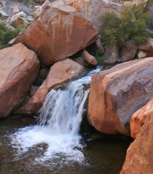
Bright Angel Creek | Sinjin Eberle
In the past few months, American Rivers, along with our local partner Grand Canyon Trust, has come forward to take on the current challenges facing the Grand Canyon. But many have asked why we are doing this – why would we take on such a potentially contentious and difficult collection of issues and wade into this array of threats? Does our involvement really have anything to do with the river? For those, I have a number of thoughts:
Respect
Respect for the place. Respect for all of the wild places that we believe should remain unmarred and iconic. Respect for the generations of people who identify with its sanctity and undeveloped nature most intimately. Simply, respect for the awe it inspires and the impact it has on all eyes who gaze upon it.
Wonder
The Grand Canyon is one of America’s wonders, a World Heritage site, and a gift to every culture and every nation around the world. Our gift, by geography and birthright, is a gift of wonder to all humanity, and it should remain intact and inviolable.
An Apt Reminder
The Grand Canyon reminds us of who we are, and how our place in this world is really only a figment of our own importance, not of its. The canyon reminds us of time and space and scale, and while the canyon’s may be long and large and grand, ours is short, small, and humble.
The canyon also reminds us of our values, and what is important to us as a people, rather than those among us who simply seek profit. It acts to refresh our beliefs, and reminds us what is right versus what is wrong.
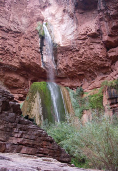
Grand Canyon Ribbon Falls | Sinjin Eberle
Grandeur
All Americans, and all citizens of the world, need more places of grandeur and space to celebrate, contemplate, and revere in awe and appreciation. To be in the presence of forces larger than any one of us, and greater than the sum of all of us.
Because, it’s the Colorado River
The Colorado River is the lifeblood of the American Southwest. It quenches the thirst of over 35 million people and grows the food of an entire nation. It also fuels a $1.4 trillion dollar economy that employs 16 million people across 9 states. And, it is the bedrock feature that drives how we enjoy and experience the Southwest and its magnificent landscapes whose watershed threads through nine of our most iconic national parks and monuments.
The Grand Canyon, like so many of our last wild places, deserves to be protected – for us, for future generations, for the people of the past, but most importantly, for itself. That’s why I am proud that American Rivers, in partnership with the Grand Canyon Trust, is confronting the efforts by greedy outside developers to erode the sublimity and sanctity of this amazing place. It’s why everyone should stand up in defense of the canyon, with our words, our actions, our visits, and our spirits.
I hope you will join me in the latest fight to preserve one of our most important, and iconic, landscapes.