Today we highlight another of the new Wild and Scenic Rivers that were designated recently by Congress. The Missisquoi and Trout Rivers became the first Wild and Scenic Rivers in Vermont. These are another example of the Partnership Rivers model, a collaboration between local communities and the National Park Service to protect and mange Wild and Scenic rivers. Below is the captivating testimony of Chris O’Shea, board member of the Missisquoi River Basin Association who we worked with way back in 2008 in support of the legislation to study the Missisquoi & Trout Rivers for Wild & Scenic River status. His words really capture why communities are fighting to keep their wild and scenic rivers as they are.
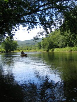
Missisquoi River | Luce Beaulieu (flickr)
Thursday, April 24, 2008 at 10 a.m
U.S. House Natural Resources Committee
Good morning. On behalf of the deer, moose, ospreys, beavers, brown trout, loons, brown bears, bobcats, beavers, foxes, bald eagles, snapping turtles, fisher cats, porcupines, mink, ravens, muskrats, coyotes, geese, herons, owls, river otters, and the good people of the ten communities that lie along the Missisquoi and Trout Rivers, I thank you for hearing this testimony on why these two rivers are worthy of study by the National Park Service for possible inclusion in the Wild & Scenic program.
Where these rivers run there are no shopping malls, no big box stores, no multiplexes, no four-lane highways, no gated communities, no stoplights.What’s there, is open spaces of forests and fields, beautiful four-season open space that stretches from Lake Champlain to the Green Mountains and beyond. The defining factor in all that open space is the Missisquoi River, it’s broad flood plain lending itself to agriculture from the time of the Abenakis to the days of Agrimark. In summer it’s a ribbon of green, in winter a frozen white wonder. If you love to hunt or fish, skate or swim, paddle or pedal, you will love where these rivers run.
The Missisquoi, the name comes from the Abenaki term for crooked river, is one of the last watersheds remaining in the United States that is devoted almost entirely to family dairy farming. Even within the boundaries of the villages that the rivers flow through you will find family farms along its fertile banks. And while many will decry agriculture as a major cause of water pollution, it is the main reason the Missisquoi and Trout Rivers are worth the time and money to preserve them and the way of life family farming offers. Agriculture and clean water can co-exist where the people are willing and the necessary funding is available.
There is plenty of pollution, mostly in the form of excessive phosphorous, along these rivers, as our group has documented. Missisquoi Bay, where the river empties into Lake Champlain eighty miles from its headwaters, is impaired and the current object of a multi-million dollar federal Clean & Clear clean-up program.
None of the ten villages along these two rivers has more than a thousand people living in it, and most have less than five hundred. Only three have the infrastructure necessary for further economic expansion, and this is another place where the Wild & Scenic program could aid those communities with both guidance and funding.
Why, you may ask, seek Wild & Scenic status for a place that is already wild and scenic? Because we want to keep it that way and without the ways and means to hold off the forces of urbanization, the greater Missisquoi Valley will eventually look just like everywhere else. As an old dairy farmer said to me recently: you know, we’re a place that can still pretty much feed it’s own, and I do believe that’s worth something to somebody.
Already we are seeing market forces eroding the family farms. Go big or get out is the mantra too often heard. Or go small and organic. The river flows to the sea, the milk to market, and the money to the agri-giants. If by preserving the river we can preserve the families living along it, then we will have made government that is truly of, by, and for the people.
It is these family farms that provide easy access to the river, whether you want to fish, swim, paddle, or ride your bike along the rail trail. Some of the best flatwater paddling in New England can be found on the upper reaches of the Missisquoi and the Trout are a place where a fly-fisherman can have a pool to him or herself on a Saturday morning. Big Falls will make you afraid of the river, Green River Farm will make you want to jump in it.
Although the Trout is much smaller, it should be included in the study as well because it is largely a microcosm of the greater Missisquoi, deep pools, shallow runs, open farm meadows, hard and softwood forests. If our studies reveal that the Missisquoi is not suitable for designation, we are quite certain that the Trout will be. And if both make the grade, as any brother and sister should, it’s a good day for the wild life.
Another unique factor in this designation is that the Missisquoi flows north into Quebec for fifteen miles and then turns back south into Vermont in the town of Richford. Already our Canadian friends have asked about what kind of possible joint venture this wild & scenic designation sets up between our two countries. In an era of growing fear and loathing along our borders, leave it to a great river to calm troubled waters. As the river changes its flow with each new spring, so too must we change to keep it clean and healthy. We are not fighting change here, only trying to channel it in a direction that benefits the river and the living beings along its banks. It may not happen in my lifetime, but by my children’s time a glass of clean water will become far more valuable than a barrel of crude oil. Please help us leave our children those healthy waters.
The Colorado River Initiative connects river recreationalists to some of the more off-the-beaten-path sections of the Upper Colorado by developing new river access points and connecting existing public lands through land acquisition and conservation easements. Since 2011, six new parcels have been acquired in underutilized reaches of the Upper Colorado as a part of this effort.
Eagle County is fortunate to have two beautiful rivers flowing through its boundaries, which are assets for recreation, tourism and community health. The Eagle River Blue Trail, comprised of the Eagle and Upper Colorado Rivers is building on attitudes favoring conservation and protection of these natural community assets. The Blue Trail works to connect a number of existing initiatives on both the Eagle and the Upper Colorado together to form a strong, connected river corridor system for locals and tourists to enjoy.
The keys to the success of the Colorado River Initiative are an organized and focused Open Space Program and strong partnerships with local entities. Thank you to Eagle County Open Space, Eagle Valley Land Trust, Eagle River Watershed Council, Bureau of Land Management, The Conservation Fund, Great Outdoors Colorado, and Colorado Parks and Wildlife for working seamlessly to protect the river corridors that help make Eagle County a special place to live and play. American Rivers is excited to be a part of this great group as we embark together on the Eagle River Blue Trail.
Would you like to learn more about the great river access available to us through Eagle County Open Space? Check out the Colorado River Recreation Opportunities Map or the Eagle County Open Space Website for more information. How have you been enjoying the new recreation opportunities along the Eagle and upper Colorado Rivers? Let us know in the community forum!
If it can be said that it takes a village to raise a child – meaning that it takes more than just the parents to develop a young person into a happy and productive adult – the same could be said for protecting our natural environments. It takes more than just one organization or one community to protect our open spaces and river environments – it requires a collaboration that accepts many hands.
In the Eagle Valley in central Colorado, American Rivers has partnered with the Eagle Valley Land Trust to expand and protect key open space lands along the Eagle and Upper Colorado Rivers. One of our valued partners in that effort is Matt Stern, the Land Stewardship Specialist at the Eagle Valley Land Trust. We recently were lucky enough to grab a few minutes of Matt’s time to learn a little more about the Eagle Valley Land Trust (EVLT) and the great work they do to protect rivers and open space in Eagle County.
Matt, thanks for taking the time to talk with us and thank you for your involvement in protecting the Eagle River corridor. I wonder about your background – did you spend a lot of time outside as a kid? What drew you to the work that you now do for the Eagle Valley Land Trust?
I grew up exploring western open lands and rivers in the West with my family. We were always looking for a new river to fish, a lake to paddle, or a mountain to climb. This enjoyment of wild places, coupled with a degree in Environmental Studies from Montana State University, inspired me to pursue a career in protecting rivers, agricultural lands, and open spaces.
That sounds like a great way to grow up! I can see how that would shape your interest in conservation. What do you do for EVLT and how does that fit into the conservation landscape of Eagle County?
Over 7,000 acres of open space in Eagle County has been preserved in perpetuity by the Eagle Valley Land Trust (EVLT) and its many partners. The Eagle Valley Land Trust itself currently has four properties under easement, protecting around 600 acres adjacent to the Eagle River. In total, we are protecting nearly 4 miles of the Eagle River corridor, ensuring that the Eagle will continue to welcome access for recreation, while supporting habitat for beavers, river otters, bald eagles and a local winter elk herd.
These places are what define our community, our economy, and our way of life.
Long-term protection of conserved land into the future is central to the mission of any land trust, and with each conservation project success there comes a permanent responsibility for preservation of those lands. One of the most beautiful and challenging aspects of land conservation is that the land is constantly in motion, changing with the seasons and the years, ever evolving. New noxious weeds sprout up, fencing deteriorates, floods change the course of rivers and streams, animals inhabit new areas, and social trails develop. It is a constant process and EVLT helps landowners address these complex problems to preserve their property. My position provides a toolkit of information and guidance for landowners in the face of these ever-changing conditions.
I know river recreation is very popular in Eagle County – how have you used recreation as a tool to build support for your conservation work?
Public access to our rivers and streams is a priority for our community. EVLT’s work supports recreation on public lands, particularly those owned by towns and Counties. Because the public can recreate on places like the Eagle River Preserve or Miller Ranch Open Space parcels, they support our conservation work. Our active, outdoor lifestyle in Eagle County and the Central Rocky Mountains revolves as much around our waterways as it does around our mountains. The Eagle River is a hub of activity for our residents and guests, and the river serves as a prime economic driver for our local outdoor recreation and tourism-based economy. Whether your passion is fly fishing, paddle-boarding, boating, rafting, kayaking, tubing, berry picking, bird watching, or simply enjoying a leisurely stroll while listening to the sounds of rushing water, there are some wonderful stretches of land and hidden gems that have been protected forever along the Eagle River. It is vitally important that we continue to protect and preserve access to our Eagle River for people – for ourselves, our future generations and our economic well-being.
I imagine that protecting a lot of these parcels takes coordination among many different stakeholders. How do you work with your community and elected officials to engage them in recreation and conservation initiatives?
Several marquee conservation projects led by The Eagle Valley Land Trust, in partnership with Eagle County’s Open Space Department, local municipalities, and our philanthropic investors, have preserved important lands along the Eagle River for the benefit, education and enjoyment of our locals and guests. EVLT and our conservation partners are excited about our positive and successful work to save the natural spaces and special places that provide public access to our rivers, creeks and streams.
Although Eagle County’s current leaders also care about permanently conserving important land to benefit the public, the Land Trust has no formal relationship with the County. The County and the Land Trust occasionally come together to collaborate on conservation projects in a couple of ways.When the County uses its dedicated open space funds to purchase land for conservation, the County may seek out a contract with EVLT in the same way that we may contract with a private property owner, because that contract ensures the land will be conserved in perpetuity.
How do you work with private landowners to protect parcels of land?
One of the ways a conservation project can come to our attention is when a property owner approaches the land trust with area parcel of land they are interested in protecting with a conservation easement, and an assessment is made about the conservation values that exist on that land. “Conservation values” has a specific legal meaning defined by the IRS and falls into four categories:
- Recreation
- Habitat
- Open Space
- Historic Preservation
The Land Trust evaluates every project a landowner may bring to us using these four criteria. If we find significant conservation values do exist and determine they are compelling to protect and preserve for our community, we will begin working with the landowner to apply protections to that land. We work with some landowners who may want to provide public access, and other landowners who don’t – either is okay.
EVLT has a number of privately-owned parcels along the Eagle River, including The Miller Ranch Community Open Space, which provides public access on 32-acres and over a mile (that’s more than 17 football fields!) of river frontage along the Eagle just east of Edwards. Additionally, the Eagle River Preserve is a 72-acre open space oasis in the heart of Edwards which boasts over a half-mile of public river access for our community.
In some cases, EVLT has helped landowners preserve their private ranches and farms, for the purpose of helping produce more local food. The results of this approach is that the community’s food is grown closer to home, is fresher and requires less energy to produce, and is holistically more sustainable. Preserving these farms also reduces water demands, increasing opportunity for our rafting and fishing experiences, while diversifying our local economy by retaining these sectors as population grows and development pressure increases. By protecting private land, EVLT and the community can continue to preserve its roots in ranching and other important local history into the future.
For those who have travelled in Colorado along Highway 24 to and from Leadville, the wetlands habitats to the west of the highway (a few miles north of Leadville and just north of the old closed down gas station) are areas that will forever be protected.Is there a specific project that EVLT has worked on that highlights all the key components of furthering conservation and recreation goals?
The Taylor City Conservation Easement represents two different conservation values rolled into one. First, Taylor City represents a 19th century mining town that was part of the historic mining and railroad past of Colorado. This storied past is gone now and in Taylor City, as in other forgotten towns of Colorado, there are only a few foundations, relics and mining pits to remind us of what once were the “boom towns” that brought to our state many of the residents who helped create the Colorado we know today. Second, this conservation easement protects over 30 acres of land that includes the headwaters of the Eagle River and associated wetlands. The total acreage protected by the Taylor City Conservation Easement is 62 acres was conserved in 2003 through a collaborative effort of the Eagle Valley Land Trust and the Eagle River Watershed Council. Funding was obtained through Great Outdoors Colorado, Natural Resource Damage Funds and private funders.
The Taylor City conservation easement land is best described by its owner, Marjorie Westermann, who said:
I have lived on Tennessee Pass since 1978. I now have the opportunity to fulfill a dream by placing the entirety of Taylor Hill Placer under a conservation easement. I asked the Eagle Valley Land Trust to spearhead this preservation. The wetlands are a riparian paradise – home to busy beaver, muskrat, pine marten, ermine, mink and a host of birds including mallards, green-winged teal, lesser scaup, red-tail hawk, ptarmigan and owl. Until the ponds are snow-covered and frozen, brook trout look like a hailstorm at day’s end, catching bugs until dark when the bats take over. German brown trout swim gracefully in the ever-changing channels and chest-deep holes of pure streams. This is a watery landscape and feeding ground for elk and deer, where black bears are occasional visitors but still enjoy a drink. Coyotes howl from the abandoned railroad tracks across the meadow and fox are often seen playing, catching mice or looking in our windows.
Taylor City is one of several conservation areas held by the Land Trust that is under private ownership. While it is not accessible to the public with physical access to the property, as the headwaters to the Eagle River, it provides an incredible incubation environment for the river. It also helps provide the scenic panoramas and “visual access” that we all value so highly in Eagle County. Taylor City is an in-holding in the National Forest, and as a conservation easement, will remain preserved as an asset to the surrounding National Forest property in perpetuity.
There are nearly 1,700 land trusts nationwide doing exactly what we are doing. Over the decades, these land trusts have preserved over 50 million acres nationwide, an area about the size of Nebraska. By working together, groups like the EVLT and American Rivers have been successful at preserving open space, our heritage legacy, and clean water for wildlife, recreation, agriculture, and communities for future generations.
Thank you, Matt for taking the time to chat about the great work you are doing for the Eagle River – one of my favorite tributaries of the Colorado.
Do you have other questions to ask Matt? Interact with us on the community forum and get your questions asked there!
Picture a tranquil dirt road through the forest, sloping downhill until it crosses a dry stream bed and winds away through the trees on the other side. There’s a good chance that the next time it rains, that road won’t be quite so peaceful.
In forested landscapes like the Sierra Nevada Mountains, sediment pollution from roads (especially dirt roads) is a widespread issue with huge impacts on our waterways.
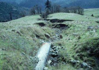
Poorly designed road drainage can result in severe erosion
Roads remove the vegetation that normally holds soil in place, and roads also intercept and concentrate water as it flows downhill; both make it easy for water to carry soil from a road to a nearby stream. Enough sediment-laden runoff can alter streams, harm fish and other aquatic animals, and impact the quality of water that people rely on.
Fortunately, well-designed roads minimize the damage by spreading the water out frequently and catching sediment before it gets to a waterway.
The U.S. Forest Service recognizes this, and is in the process of repairing or shutting down the roads with the worst impacts throughout our national forests. American Rivers is partnering with Tahoe National Forest in California to survey roads for signs of erosion this spring, and to identify where to focus resources to solve this problem. Doing so will protect the headwaters of the Yuba, Bear, and American Rivers, which flow out of Tahoe National Forest.
Rivers are more than running water. They’re an accumulation of everything that happens in their watersheds. In order to truly protect rivers, no matter where they are, we need to look past their banks and care for the landscape that surrounds them.
Western Montanans are lucky enough to live amongst truly wild places: valleys created by free-flowing rivers, seas of peaks reaching for the sky, and largely intact habitats that are filled with all of species that were present at the time of European contact. The Rocky Mountain Front – that dramatic geography where the mountains and rivers of the Northern Rockies meet the Great Plains – is one of those places. But until recently, it was a largely unprotected landscape.
The Front harkens back to a different era. Working ranches still dominate the landscape. Wildlife and culture regularly mix in and around the few communities spread along Highway 89/287 as it threads its way north through the prairie. Looking west, jagged, limestone “reefs” rise up from the plains. These walls of rock are incised in regular intervals by canyons containing gin clear water from last winter’s snows.
Numerous trails follow these canyons west into the interior worlds of the Bob Marshall Wilderness complex, worlds inhabited by grizzly bears, huckleberries, and elk living in mountain meadows and verdant thickets, along the sides of rushing rivers that are framed by imposing, snowcapped peaks. Those fortunate to experience the Rocky Mountain Front from either the plains or the mountains cannot help but be moved by it.
Sun River, MT
When I first moved to Montana 8 years ago and began exploring the Front I thought of it mostly as a backpacker’s paradise. Some years later however,
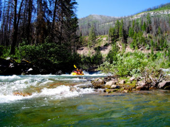
I bought a packraft, a single-person, 5-pound, packable whitewater raft that begs to be used for exploration. All of a sudden the streams of the Rocky Mountain Front morphed into premier paddling destinations as well.
And what glorious streams they are! Birch Creek, Deep Creek, the Dearborn River, the Forks of the Sun River, the Teton River…. gorgeous, wild, headwaters streams running through a patchwork of federal lands, many with outstanding wilderness characteristics.
For nearly a decade, a coalition of landowners and conservation groups has been working to protect this landscape, hammering out a collaborative solution called the Rocky Mountain Front Heritage Act. On December 19, 2014, President Obama signed into law the National Defense Authorization Act (NDAA), which just so happened to carry with it a number of natural resources bills that had been waiting for their day in the sun, one of those being the Rocky Mountain Front Heritage Act.
While the NDAA sparked considerable controversy in both form and substance – some disagreed with the compromises made and questioned the appropriateness of adding natural resource bills to a must-pass defense bill – the Rocky Mountain Front Heritage Act (along with the North Fork Watershed Protection Act) is a clear win.
The Rocky Mountain Front Heritage Act protected 275,272 acres along the Front, adding 67,160 acres of Wilderness to the Bob Marshall Wilderness Complex and designating another 208,112 acres as a “Conservation Management Area” that aims to protect the front as it is while allowing existing uses. The last time Congress designated a wilderness area in Montana was over 30 years ago in 1983, when it designated the Lee Metcalf Wilderness.
Please join me in celebrating the passage of the Rocky Mountain Front Heritage Act. Cheers to the people who worked together to make it happen! In this era of hyper-partisan politics it is inspiring to see concerned citizens from multiple political persuasions working together to protect a place that they love.
Governor Hickenlooper recently received the initial draft of the Colorado Water Plan. This “plan” has been in the making since the drought year of 2002, and it’s not over yet. Work on the Plan, including public input, will continue through the coming year, with the Final version due to the Governor in December 2015.
The Colorado Water Plan in many ways is indeed historic. Water planning and development has traditionally been based upon the needs of individual water rights and utilities. The Water Court and State Engineer act as judge and referee, but the process has always been on more of a piecemeal basis, rather than following a guiding principle. This is the first time that Colorado has attempted a cohesive and comprehensive approach to planning for future water needs on a statewide basis, taking into account the array of conflicting priorities encompassed under a single strategy.
So why do this now?
The answer, is growth – we are rapidly outgrowing our supply of water. To many Coloradoans, this may come as a surprise – water flows thoughtlessly from our faucets, irrigated farms fill the valleys and plains with a lush carpet of green, and sprinkled lawns and parks grace many of our communities. But streams gushing from melting mountain snows struggle to fill both rivers and reservoirs every year. This perceived plenty is often interrupted by periodic drought, noticed when watering restrictions are imposed, and the public is alerted to a simmering problem by a frenzied media. The time of shortage is quickly forgotten with the next heavy snowpack and a return to “normal”.
But the well-watered world we have engineered is not “normal.” Colorado is an arid state, where water has always been a scarce and often contentious resource. Despite our best efforts, Colorado has yet to become like Ohio and that isn’t likely to change with the new Colorado Water Plan. In fact, the available supply of water for growing demands is projected to decline.
The result is what is called the “Gap”, the difference between the water we think we’ll need in the future and the water available to satisfy those needs. Filling this gap, finding water for a population expected to double by 2060, is the primary goal of the Colorado Water Plan.
The Governor has directed that the Plan must provide for several core values. These include vibrant and sustainable cities, viable and productive agriculture, a robust recreation and tourism industry, smart land use, and a strong environment, including healthy watersheds, rivers and streams, and wildlife.
Many projects that might supply water for these core values are listed in the Plan. Hundreds of water storage, supply and other projects have been cataloged. Among them are many potential conservation efforts that could help restore and protect rivers and watersheds around the state.
But many of the proposed projects could end up doing more harm than good. Newly proposed trans-mountain diversions would drain even more water from the already heavily tapped and degraded Colorado River. New dams and diversions may have a place in filling the “gap”, but the truth is that there is only so much water – we can’t create more. What will these new reservoirs be filled with? It could be argued that every drop of water from the continental divide to the Utah border has already been spoken for – so now what do we do?
Colorado’s future water supply won’t come by simply draining more rivers to a breaking point. It must come from greater conservation, efficiency and re-use of the limited water supply we have. The Colorado Water Plan should devote far more space to this effort, rather than from fanciful pipedreams of imagined new water from the Colorado River system.
We also have to recognize that growth, the catalyst for the Plan, must be dealt with. Colorado’s population has doubled every 40 years or so through the last century. The Colorado Water Plan hopes to provide water for a population double what we have today; 10 million, by 2060. It is reasonable to expect that our population will double again before this century is out, with 20 million Coloradoans by 2100. Where is the water going to come from for these new, unaccounted for millions of thirsty mouths?
And keep in mind that Colorado is not alone in this dependence – the cities of the lower Colorado River Basin states, including Las Vegas, Phoenix, Los Angeles, and San Diego, will be growing as well and at a similar rate. Regionally, the situation is difficult to solve, at best.
It’s time we take a hard look at the reality of water and growth in Colorado. If we really want to plan, and supply water for each of the Governor’s stated core values, we must reexamine more than just how we traditionally secure water – more diversions, engineered rivers, and reservoirs will not increase the state’s basic supply. We need to think very differently, and more creatively, than the current Plan envisions – that could make the Colorado Water Plan truly historic.
Both visitors and local users of the Waccamaw River Blue Trail have the opportunity to further explore and appreciate the great resources that are available to them. . Here is a quick highlight of some of our greatest successes along the Waccamaw River:
- The Waccamaw River Blue Trail, which is supported by a diverse group of partners from both North and South Carolina has been expanded to include the complete river, beginning near Lake Waccamaw, meandering through the Waccamaw River Heritage Preserve, City of Conway, and Waccamaw National Wildlife Refuge before merging with the Intracoastal Waterway and ends at Winyah Bay near Georgetown. This fall, American Rivers and our partners released a new Waccamaw River Blue Trail map that helps users navigate the river and its sites and interests.
- The Waccamaw National Wildlife Refuge, through a strong community partnership, was able to conserve approximately 2000 acres with a $2.5 million grant from the Land and Water Conservation Fund.
- The Waccamaw River Blue Trail has made enormous strides in protection with help from the North Carolina Coastal Land Trust who purchased 670 acres of bottomland hardwoods and cypress-gum swamp along the Waccamaw River just south of Lake Waccamaw State Park in North Carolina. This land conservation acquisition serves to protect the water quality, environmental health, diverse fish and wildlife, and the outstanding recreation opportunities on the Waccamaw.
The new year is shaping up to be even better than the last as regional partners are working hard on pursuing conservation and protection opportunities along the Waccamaw, especially those that emphasize connectivity and promote recreation. The City of Conway has also become a supportive partner of efforts with Mayor Alys Lawson acknowledging that “We know that our environment is really one of the things that sets the City of Conway apart, and it has for generations.”
There are several opportunities for eco-tourism in the area and many are recognizing that natural amenities are a not only of value to the community, but also serve as a draw to Myrtle Beach visitors that may be looking for a change of pace from those salty, sandy beach days. As these pictures of a Waccamaw River winter sunset show, there is definitely a show worth coming for.
The Waccamaw River Blue Trail not only works to improve recreational opportunities as well as supporting the local economy, but it also helps to educate citizens, local governments, and elected officials about the importance of the river as a community asset, increase community involvement in the river, and support conservation. Hopefully 2015 is a year for many celebrations on the Waccamaw. Check back often to see what announcements have been made regarding our work and plan a trip to enjoy this one of a kind river.
On January 15, 2015 the Environmental Protection Agency released a scientific report demonstrating the importance of small streams and wetlands to downstream water quality. The report, Connectivity of Streams and Wetlands to Downstream Waters, is based on current scientific research, specifically 1,200 publications from peer-reviewed scientific literature. The EPA’s report concludes that there is an undeniable chemical, physical, and biological connection between small streams, wetlands and floodplains to downstream waterbodies such as lakes, estuaries, oceans, and larger river systems.
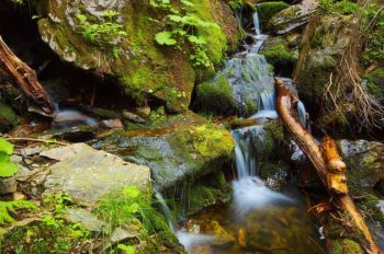
Small unknown stream
The report will be used to help finalize the proposed Clean Water Protection rule, which was first proposed in the spring of 2014. The final rule will restore protections to over half of America’s streams and millions of acres of wetlands. Although these important waters contribute to the drinking water supplies of one in three Americans they are currently vulnerable to degradation.
This report demonstrates that the Clean Water Protection rule is grounded in science. The report makes the sound, scientific case for what we have long known- what happens upstream will affect downstream. We have to protect the smaller streams and wetlands in order to comprehensively protect larger bodies of water. Anyone who has an interest in healthy rivers – for drinking or recreation – can appreciate this report and should support the proposed Clean Water Protection rule.
Update: Feb 6, 2015
Three weeks after the Poplar Pipeline spewed 40,000 gallons of oil into the Yellowstone River in eastern Montana, cleanup efforts have been called off due to dangerous ice conditions. The spill, which occurred on January 17, contaminated the city of Glendive’s drinking water supply and sickened local residents. It was the second major oil pipeline spill in the Yellowstone River in four years. In July 2011, Exxon’s Silvertip Pipeline dumped 63,000 gallons of oil into the river near Laurel, Montana.
During the abbreviated cleanup, a total of 1,200 gallons of oil was allegedly recovered from the river. At the peak of the cleanup effort, a spokesman for the company that operates the Poplar Pipeline said that oil was being recovered at the rate of one teaspoon every ten minutes. At that pace, it would have taken 1,753 years to remove all the oil from the river.
The Poplar Pipeline, like hundreds of pipelines that cross underneath the nation’s rivers, was constructed in the 1950s and buried just eight feet under the bed of the Yellowstone River when it was last inspected in 2012. Federal regulations require that pipelines be buried only four feet underneath rivers despite evidence that large rivers like the Yellowstone can scour 40 feet deep during floods and ice jams.
January 24, 2015
Nearly a week has passed since an oil pipeline ruptured underneath the bed of the Yellowstone River in eastern Montana, contaminating drinking water supplies for the 6,000 residents of Glendive, sickening several people, and taking an unknown toll on fish and wildlife.
Here’s what we know about the spill so far:
According to the pipeline owner, Bridger Pipeline LLC, 40,000 gallons of light crude oil gushed from a 12-inch pipeline that ruptured underneath the bed of the Yellowstone River. Of that amount, 10,080 gallons were recovered from inside the pipeline and 630 gallons of an “oily, watery mix” have been recovered from the river.
Oil recovery efforts have been hampered due to the fact that the Yellowstone River in the vicinity of the spill is locked under two feet of ice. Meanwhile, an oily sheen has been spotted as far down river as Williston, North Dakota.
Testing earlier this week found that Glendive’s drinking water supply had three times the amount of benzene, a known carcinogen, than the Environmental Protection Agency (EPA) deems safe for human consumption. Following the installation of a new filter at the city’s water treatment plant, benzene levels have dropped to acceptable levels. The city is expected to lift its bottled water order this weekend.
Bridger Pipeline LLC has a long history of pipeline safety violations. According to the Pipeline Safety Trust, the company has double the average number of pipeline safety incidents per mile of pipeline over the past six years.
Of Bridger Pipeline LLC’s 384 miles of pipelines, 186 miles of pipeline, or 35%, were constructed with 1950s-era pipe using faulty welds. It is unknown at this point whether the section of pipeline that ruptured under the Yellowstone River was of this variety.
The last time this pipeline was inspected was in 2012. At the time, the pipeline was buried as shallow as eight feet under the bed of the Yellowstone River, which is well within the river’s scour depth.
Meanwhile, as this oil spill tragedy continues to unfold, the U.S. Senate is debating a bill to approve the controversial Keystone XL pipeline, which would cross the Yellowstone River approximately 20 miles upstream of the spill site. On the other side of the capitol, the U.S. House passed legislation on Wednesday that would expedite the approval of new natural gas pipelines, giving government regulators less time to evaluate their potential environmental impacts.
Take Action to Stop Future Oil Spills into Our Rivers
Since 1986, pipeline oil spills have caused more than 55 deaths, 2,500 injuries, and more than $7.7 billion in damages. Tell the Obama Administration to protect our rivers by strengthening the environmental standards for these pipelines.
As much of the US is in the grip of a frigid arctic air mass, California is in the grip of a ridge of high pressure that has blocked the procession of drenching storms we had in December.
A similar pattern, dubbed the Ridiculously Resilient Ridge, set up at this time last winter and pushed the normal storm track to the Pacific Northwest and Canada, resulting in one of the driest years on record in California. This winter, the December storms got us off to an above average start and raised hopes that the drought was coming to an end. But with the three weeks of dry weather and a forecast for at least one more dry week, we will likely fall below average by January 15th. If the Ridiculously Resilient Ridge returns and blocks precipitation for the rest of the winter, we will be in trouble.
It seems unlikely, at least statistically, that a drought as bad as last year will recur, but after three dry years for our rivers and fish, we have little resiliency and water storage is far behind needs. This is especially true for the San Joaquin River. The December storms helped, but California reservoirs remain about half of average for this time of year.
Our wet season is far from over, and the seasonal forecast from the National Weather Service shows a probability of above average precipitation this winter, so there is some basis for hope. However, as each day dawns warm and dry, we drift closer to another year of drought. Already, the state and federal agencies responsible for managing California’s water system and protecting imperiled fish and wildlife have developed an Interagency 2015 Drought Strategy that lays out a plan to adapt to what could be year 4 of a ridiculously resilient drought. This is one strategy everyone would be glad to have gather dust on a shelf.
It’s been said that good things come to those who wait.
After four decades, the wait is finally over for all the citizens and conservation groups who have patiently and persistently fought to maintain the integrity of the North Fork of the Flathead River watershed along the western boundary of Glacier National Park.
Last month, President Obama signed legislation to formally withdraw 430,000 acres of public land in the North Fork watershed from all new mineral entry. The legislation fulfills a 2010 deal negotiated between the state of Montana and the Canadian province of British Columbia.
The North Fork is born in the mountains of British Columbia and flows south for 153 miles before emptying into Flathead Lake, the largest natural freshwater lake in the western United States. Over the years, it has faced multiple threats from proposed open-pit coal mines, gold mines and oil and gas drilling, prompting American Rivers to name it one of the nation’s Most Endangered Rivers in 2009.
As a follow-up to the 2010 North Fork deal, mining and energy companies with valid existing claims on the Canadian side of the watershed were paid $10 million to forfeit the right to mine and drill in the future. While mining and energy companies on the U.S. side of the border voluntarily surrendered more than 200,000 acres of claims, roughly 50,000 acres of existing claims remain. Extinguishing those claims will be the next chapter in the North Fork saga.
If you’ve never been to the North Fork, it is difficult to describe its beauty in words. For while the river itself is crystal clear and the views of the Livingston Range are truly spectacular, the North Fork’s real beauty lies in its abundance of wildlife. As one of the last intact low-elevation river corridors in the western U.S., it is home to every wildlife species that was present when Lewis and Clark passed through Montana more than two centuries ago, including the highest concentration of grizzly bears in Interior North America.
I was fortunate to spend a winter doing wildlife research in the North Fork when I was a graduate student at the University of Montana in 1991. While I was there, I kept a daily journal. As I started writing this blog, I re-read that journal for the first time in a long while. One thing I wrote really stuck with me:
“In the future, my concept of beauty will be measured against this place.”
There are many places I’ve been to that are more beautiful to the eye than the North Fork, but there are few whose wild soul remains so intact.
Thanks to you and everyone else who rallied to her defense for so many years, the North Fork’s wild soul will continue to inspire people for generations to come.
Today’s blog is a guest post by Howard Bridgman.
The sun had fallen behind the trees and the nip of winter to come was in the air as the paddlers were greeted at the Dorchester Boat Club with hot coffee, snacks, and local craft beer from Freehouse Brewery. Freehouse, a supporter of American Rivers and the Ashley River Blue Trail, is located just downstream on the banks of the Ashley in North Charleston. People were alive with the joys of our scenic paddle and the prospects of hot, steamed oysters soon to come.
The event was American Rivers’ inaugural paddle trip and oyster roast for the Ashley River Blue Trail, which flows from Summerville to Charleston, South Carolina. We invited members of municipal governments, local businesses, and paddlesport enthusiasts to explore the river with us and better understand the importance of its recreation benefits and in making sure it is accessible and remains healthy for the future. A turn out of approximately 70 local leaders for the event on a cool autumn day fulfilled that goal.
For many the trip was their first exposure to the upper Ashley River, and the purpose of our day was to let people see firsthand what a gem the Ashley is while also understanding that actions need to be taken to ensure it remains that way. The trip was followed with a warm-up around the fire and words from Gerrit Jöbsis, Southeast Regional Director of American Rivers, about how community-led Blue Trail initiatives can and have improved recreational access while putting in place safeguards to ensure it will remain a valuable community asset for future generations. A video of the Hitchcock Creek Blue Trail was shown, a community success story where citizens around Rockingham, NC created a paddle trail that improved access, created greenways, protected critical riverside lands, and now serves as a driver for the local economy. Robust discussion followed about how the Blue Trail can be an engine for improved recreation and conservation on the Ashley River. The evening drew to a close with roasted oysters and good conversation around the fire. New friends were made and many left inspired about the potential of the Blue Trail and the actions they and their community can take to keep the Ashley River the gem that it is.
Howard Bridgman, former Summerville Town Council member and founding member of the Ashley Scenic River Advisory Council, serves as the Ashley River Blue Trail Coordinator and works to connect local communities to the river through recreation and finding ways to ensure its long-term health.

