It is such a thrill to complete a project! Especially a two and half year collaborative, planning project that involves several organizations, governments and individuals who have spent hundreds of hours in meetings, on field tours and site assessments, and researching and writing detailed information.
It gives me great pleasure to announce that the Upper Nooksack River Recreation Plan has been finalized and was released to the public today. This new, comprehensive plan will help guide the management of recreation and natural resources along the upper Nooksack River system in Washington state. The plan recognizes and supports the economic and health benefits of recreation, along with protection and restoration of the natural and cultural values of the upper river basin.
Nearly 600 individuals and organizations, including landowners, businesses, paddlers, anglers, hikers, skiers, and equestrians contributed to the Upper Nooksack River Recreation Plan’s development over the past two years, leading to the formulation of over 80 management recommendations. These recommendations are focused on the river corridors of the Nooksack’s North, Middle, and South forks and several tributary streams. Recommendations include improving access to the river, enhancing education and stewardship, maintaining roads and trailheads, and protecting the outstanding values of the river.
The Nooksack River is the lifeblood for local communities that rely on the river for clean water for drinking and agriculture, and for tourism income from visitors drawn to the river’s world class whitewater boating, hiking, skiing, horseback riding, fishing, mountain biking and other recreation opportunities. Outdoor recreation opportunities are important to quality of life as well as economic growth in Washington’s Whatcom and Skagit counties and across the state. For example, outdoor recreation trips and equipment contribute $21.6 billion annually to Washington’s economy, $8 billion of which is spent on activities around water, including fishing, boating, swimming and diving.
The recreation plan was developed through a collaborative planning process led by an advisory committee comprised of representatives from American Rivers, American Whitewater, Hydropower Reform Coalition, Mount Baker Club, National Park Service, Nooksack Tribe, Nooksack Salmon Enhancement Association, Pacific Northwest Trail Association, the United States Forest Service – Mt. Baker Ranger District, Whatcom Chapter of Back Country Horseman of Washington, Whatcom County Parks and Recreation Department, Whatcom Events (Ski to Sea Race), the Whatcom Land Trust, and Wild and Scenic River Tours. Planning assistance was provided by the National Park Service’s Rivers, Trails, and Conservation Assistance Program.
For more information about the recreation plan or to get involved, please contact me at wmcdermott(at)americanrivers(dot)org.
It’s one of the Seven Natural Wonders of the World, and an irreplaceable national treasure. It’s the Colorado River in the Grand Canyon, and it is the #1 Most Endangered River of 2015.
The river faces a battery of threats that could forever harm its health and the unique experience that belongs to every American. Not since dams were proposed in the 1960’s has the Grand Canyon faced such a serious attack.
[su_youtube url=”https://www.youtube.com/embed/P_KD0SBQ4YU” width=”1020″ height=”580″]
The massive Escalade construction project would irreversibly scar the fragile heart of the canyon with bulldozers, noise, and pollution. A tram from the rim to the confluence of the Little Colorado and Colorado Rivers, a hotel, restaurant, gift shop and riverside walkways would transform what has always been a wild place, sacred to many native tribes.
And that’s not all. Radioactive pollution from uranium mining threatens tributary streams of the Colorado River in the Grand Canyon. And, expansion of the town of Tusayan could deplete vital groundwater supplies, impacting the health of fragile desert ecosystems.
American Rivers and our partners at Grand Canyon Trust are calling on Secretary of the Interior Sally Jewell and the Obama Administration to use every authority to prevent damage to the river and preserve the Grand Canyon for all Americans to enjoy.
Please take action to preserve the Colorado River in the Grand Canyon for all of us, for all time.
The annual America’s Most Endangered Rivers® report is a list of rivers at a crossroads, where key decisions in the coming months will determine the rivers’ fates.
“This year’s report underscores the importance of healthy rivers to each and every American,” said Bob Irvin, President of American Rivers. “Whether it’s for clean drinking water, ample water supplies for farms and cities, abundant fish and wildlife, or iconic places vital to our heritage, we all have a stake in protecting our nation’s rivers.”
America’s Most Endangered Rivers® of 2015:
#1: Colorado River in the Grand Canyon, Arizona
Threat: Massive construction project, mining pollution, groundwater depletion
At Risk: An irreplaceable national treasure
Millions of Americans recognize the Grand Canyon as one of the most iconic landscapes on the planet. But this natural masterpiece of the Colorado River faces a battery of threats. A proposed industrial-scale construction project in the wild heart of the canyon, radioactive pollution from uranium mining, and a proposed expansion of groundwater pumping at Tusayan, all threaten the Grand Canyon’s wild nature and unique experience that belongs to every American. Unless the Department of the Interior acts to stop these threats, one of our nation’s greatest natural treasures will be scarred forever.
#2: Columbia River, Washington/Oregon
Threat: Outdated dam operations
At Risk: Healthy runs of salmon and other fisheries
The Columbia River is the lifeblood of the Pacific Northwest’s economy and environment. The river’s dams provide more than half the region’s electricity as well as flood control and irrigation, but they have also decimated the basin’s salmon and steelhead runs. As the Columbia River Treaty is renegotiated, the U.S. Department of State must put the importance of a healthy ecosystem on an equal footing with the benefits of hydropower and flood control. We can achieve this balance by releasing more water for salmon when they need it and providing fish passage beyond currently impassable dams. Since the last Treaty was negotiated a little over 50 years ago, this is an once-in-a-lifetime opportunity to do right by one of the nation’s most important rivers.
#3: Holston River, Tennessee
Threat: Toxic chemical pollution
At Risk: Drinking water supply, fish and wildlife, and recreational uses
The Holston River is rich in history and heritage, and today provides drinking water for tens of thousands of Tennessee residents, as well as water for industry, livestock, and recreation. However, the river and its communities are threatened by an army ammunition plant that has been contaminating water supplies with toxic chemical pollution for years. The U.S. Army and its Holston Army Ammunition Plant must immediately stop polluting the Holston River with harmful explosive chemicals.
#4: Smith River, Montana
Threat: Copper mining
At Risk: Water quality, nationally renowned wild trout fishery
The Smith River is one of the most cherished floating and fishing destinations in Montana. The river is home to a nationally-renowned wild trout fishery, and provides prime habitat for dozens of fish and wildlife species. The river is threatened by a huge proposed copper mine in its headwaters that could seriously degrade water quality with acid mine drainage and toxic heavy metals. The State of Montana should not permit the copper mine unless it can be designed in a way that eliminates any risk to the river’s water quality and habitat.
#5: Edisto River, South Carolina
Threat: Excessive water withdrawals
At Risk: Water supply, water quality, fish and wildlife habitat, recreation
The Edisto River is one of South Carolina’s most popular rivers for paddling, fishing, and outdoor fun. It’s also the state’s most heavily used river for irrigation, and excessive agricultural water withdrawals are threatening water quality and the water supplies of other users. While the state’s permitting process requires industrial and municipal water users to meet requirements to safeguard river health and clean water, large agribusinesses get a pass. The South Carolina House of Representatives must pass H.3564 this year to end this unfair exemption so that the Edisto, and all of the state’s rivers, can continue to provide sustainable water supplies for all, while supporting river health and recreation.
#6: Chuitna River, Alaska
Threat: Coal mining
At Risk: Native culture, wild salmon, and clean water
The Chuitna River supports Alaskan Native communities, wild salmon, abundant wildlife including moose, bear, and wolf, and excellent opportunities for hunting, fishing, and other recreation. PacRim Coal’s proposal to develop what would be Alaska’s largest open-pit coal strip mine at the Chuitna River’s headwaters poses an unacceptable threat to the economy and communities that rely on clean water and healthy salmon runs. Unless the U.S. Army Corps of Engineers denies the mine’s permit, this pristine wild river and its communities will be irreparably damaged.
#7: Rogue/Smith Rivers, Oregon/California
Threat: Strip mining
At Risk: Clean water, drinking water, wild salmon and steelhead runs, Wild and Scenic Rivers
The Wild and Scenic Illinois Rogue (OR) and Smith (OR and CA) rivers are known for their healthy salmon runs, world-renowned plant biodiversity, and outstanding recreation. However, proposed nickel mining in these rivers’ headwaters threatens their unique values. Immediate closure of the area to mining is the most effective way to help prevent the development of nickel strip mines from turning the pristine headwaters of the highest concentration of wild rivers in the country into an industrial mining zone. The U.S. Forest Service, Bureau of Land Management, and Department of Interior must withdraw this area from mining immediately to protect this wild treasure.
#8: St. Louis River, Minnesota
Threat: Copper-nickel sulfide mining
At Risk: Clean water and wildlife habitat
Minnesota’s Arrowhead region is known for its pure and abundant waters, deep forests, expansive wetlands, and recreational opportunities. However, a proposed copper-nickel sulfide mine at the headwaters of the St. Louis River, the region’s main artery, threatens drinking water, wildlife, and the treaty-protected hunting, fishing, and gathering rights of the Ojibwe people. It is critical that state and federal regulators deny permits for the mine plan because it does not sufficiently protect the St. Louis River and its communities.
#9: Harpeth River, Tennessee
Threat: Sewage pollution and water withdrawals
At Risk: Clean water, fish and wildlife, recreation
The Harpeth River is one of the few free-flowing rivers in Tennessee. It flows through one of the fastest growing regions in the country, but remains an oasis for local families, anglers, and paddlers. The river’s waters, fish and wildlife, and recreation values are threatened by sewage and water treatment plant expansions. Unless state officials require state-of-the-art technology to improve sewage treatment, the river will be overwhelmed by treated sewage pollution and public health could be compromised.
#10: Pearl River, Louisiana/Mississippi
Threat: New dam
At Risk: Healthy wetlands and wildlife habitat
The Pearl River runs through Central Mississippi and supports vital oyster reefs and marsh habitat in the Mississippi Sound. Coastal wetlands and commercial fisheries depend on the Pearl River’s flows. However, the river’s health has been compromised by the Barnett Dam north of Jackson, Mississippi. Now, a new dam has been proposed for the Pearl that would cause additional harm to river health, wetlands, and fish and wildlife habitat. The U.S. Army Corps of Engineers must reject this unnecessary and ecologically harmful new dam.
Last Thursday Governor Brown announced a farsighted $1 Billion dollar drought relief plan for California, but the $660 million allocated for flood management had many observers scratching their heads.
The Governor is absolutely right to be thinking ahead about flood: The epic ten-year Australian drought ended with the two biggest flood years on record. Below is a visual of what Californian’s need to prepare for:
[su_youtube url=”https://www.youtube.com/embed/vhatmWYkRNo” width=”1020″ height=”580″]
But if the $600 million is spent on traditional flood control projects to harden river banks and raise levees, it will do little or nothing to relieve the stresses of future droughts and floods. These projects are not only bad for the environment, but in too many cases they actually increase flood risk and degrade water quality by encouraging floodplain development.
With the Governor’s leadership, California is now poised to invest in a new kind of flood management, multi-benefit flood management projects, that will protect public safety and increase the state’s resiliency against future droughts.
California’s water and flood management system was built 50 – 150 years ago for a very different state and climate. The levees were built very close to the river in the latter half of the 19th century to flush Gold Rush mining debris out of clogged channels and facilitate navigation in the years before invention of the automobile. Fast forward 150 years and we are now forced to manage the Central Valley water system within the constraints of over 1,000 miles of aging and poorly engineered levees.
The 2012 Central Valley Flood Protection plan now calls for setting back levees and expanding floodways through a system of multi-benefit flood management projects that not only give rives more room to safely accommodate large floods, but they also improve water supply reliability, water quality, recreational opportunities, and habitat for fish and wildlife. The governor’s recent announcement is not only a down payment on a new flood management approach but also on a larger water management approach that better harnesses natural processes to meet human and environmental needs.
In particular, multi-benefit flood management projects provide many important water supply benefits.
- Water Retention and Usability: Widening floodways increases floodwater retention and groundwater recharge in a manner that could have significant water supply benefits. Floodplains capture peak flows and then release them back in a manner that provides benefits for both water diverters and ecological function. In some cases, floodplain restoration can significantly recharge depleted aquifers storing water in wet years for use in dry years.
- Reservoir Operations and Storage: Widening the regulatory floodway will ultimately create opportunities for changes in reservoir operations that will increase carryover storage from wet years to dry years. Currently, reservoir operators must keep a portion of the reservoir empty to capture dangerous floods. In late 2012, only months before the driest calendar year on record, reservoir operators were forced to release hundreds of thousands of acre feet of water to maintain the “flood reservation” behind large dams. Larger floodways would allow reservoir operators to safely release more water during large storms, allowing them to safely keep more water in the reservoir during all other periods.
- Reduce conflict between environmental and consumptive uses: Conflicts over the competing water demand for cities, agriculture, and sensitive species is one of California’s largest water management challenges. Multi-benefit flood management projects improve conditions for many sensitive species, and will thus reduce the probability that future water managers will need to choose between delivering drinking water or protecting species from extinction during future droughts.
- Reduce water demand by riparian and senior water rights holders: Widening regulatory floodways often results in the acquisition of riparian lands and water rights that can be retired in all years or fallowed in dry years. Agricultural production is still possible in a periodically inundated floodplain, but acquisition of floodplain lands creates the opportunity to fallow or retire senior and riparian water rights on floodplain lands, at least in dry years.
- Improve water quality: Irrigation and drainage of levee “protected” floodplains degrades water quality for drinking water and the environment. Restoration of floodplains and natural flooding patterns reduces both the need to divert high quality water for irrigation and the drainage related discharge of poor quality irrigation return water. In addition, restored floodplain wetlands filter and cleanse polluted waters associated with drainage from agricultural and urban lands.
Since the 1950s, the US Army Corps of Engineers has been trying to build a levee near New Madrid, MO to halt seasonal backwater flooding and promote agriculture production within the lower portion of the New Madrid Floodway. The levee would prevent the Mississippi River from reaching 75,000 acres of backwater habitat, which during the regular biennial high water events floods about 33,400 acres – about the size of Washington, DC. The wetlands in this region not only support unique species, especially during seasonal floods, but during the large flood events is an essential reproduction area for many Mississippi River fishes.
American Rivers has asked the Environmental Protection Agency to veto the project because most experts agree that the wetlands and habitat loses would be un-mitigatable. And the Final Independent External Peer Review Report for the project supports our claims.
External peer reviews of Corps projects are called for when a project is controversial or exceptionally large. During the peer review, the Corps contracts with experts through a third party to review the materials and resources used by the Corps in their decision-making process. The panel charged with reviewing the New Madrid Levee Project found several flaws in the Corps resources and decision-making, including:
- The assumptions used in the economic analysis could not be justified, e.g. the Corps claims that the main benefit for the project is an increase in agriculture producer profits, but they provided little information to justify or quantify these claims.
- The economic analysis did not take into account the changes in environmental amenities associated with the project, like revenues from recreation.
- The wetland loss was underestimated, and the wetland mitigation plan “downplays the importance of ecosystems.”
- The data used in the environmental model is out of date and insufficient for evaluating the impact of the full range of species in the ecosystem.
- The expected impacts from climate change were not considered in projecting future crop yields.
- The Corps incorrectly assumes “that wildlife can relocate if habitat is lost.”
- The Corps suggests throughout the working final environmental impact statement “that there is little to no value associated with river connectivity or flood pulse for environmental resources.”
The report is clear: the Corps’ plan to build a levee across the last natural floodplain in the region is significantly flawed. Next we wait for the final environmental impact statement – which will reveal the Corps’ final decision to move forward with the levee project or abandon it forever.
The Upper St Anthony Falls Lock closure is inspiring a lot of imagination as citizens, planners, and non-profits try to dream up a new Minneapolis riverfront. Some of the ideas were voiced at a visioning meeting in Minneapolis a few weeks ago at Mill City. My personal favorite vision: Restoring the Mississippi River Gorge.
Historically, St. Anthony Falls was the head of a six mile stretch of rapids that was a rich spawning ground for native fish capped by a 50 foot waterfall that served as a natural barrier to northern migrating fish. But parts of the rapids were flooded when the Ford Dam (Lock and Dam 1) was constructed in the early 1900s, making St. Paul the head of Mississippi River navigation. And, jealous of St. Paul’s river navigation prowess, Minneapolis built Upper and Lower St. Anthony Falls Locks and Dam in the 1960s, completely flooding out the rapids.
What’s standing in the way of restoring the rapids today? The question of whether those dams are still relevant.
With the closure of Upper St Anthony Falls Lock, the three commercial barge destinations above Lock and Dam 1 are now also closed. While recreational boats still use the locks, they probably won’t be busy enough to be relevant for navigation purposes, especially since there is a massive outreach campaign by the Stop Carp Coalition to discourage recreational lockages in order to prevent the spread of invasive carp.
And speaking of carp, are dams really the best defense against advancing carp? Maybe in the short-term, but research shows that the dams on the Upper Mississippi River and Illinois Waterway may actually promote the establishment of invasive carp.[1] Many ecologists will tell you that the best defense against invasive species is robust natural habitat filled with native species. But unfortunately, the Mississippi River in Minneapolis is far from natural.[2] Restoring the Minneapolis Gorge, completing the waterfall, and restoring all the magnificent rapids may be a better barrier against invading carp.
Aside from being a wall to invasive carp, the Ford Dam also facilitates hydropower – a renewable energy source. But, the hydropower facility may not be economically viable if the Corps of Engineers stops subsidizing the dam.[3] The federal permit to operate hydropower on the Corps’ dam expires in 2034. With river traffic on the decline, it’s likely that the Corps will determine that the dam is no longer in the federal interest before then. When that happens, the Corps will no longer subsidize the operations and maintenance of the dam, which hurts the economics of hydropower generation. The private energy company that operates the hydropower project will be solely responsible for maintaining the old dam. It’s not clear if the private energy company will be interested in taking on the responsibility for maintaining this old dam, which receives an $1.24 million annually subsidy[4] from the Corps for only 17.92 megawatts generating capacity.
So, the infrastructure might not be economically relevant for much longer. What then? American Rivers hopes that the beautiful rapids of the Mississippi River Gorge will one day be flowing again through Minneapolis.
[1] Hoff, Michael, Mark Pegg, and Kevin Irons. 2011. Management Implications from a Stock – Recruit Model for the Bighead Carp in Portions of the Illinois and Mississippi Rivers. American Fisheries Society Symposium 74:5-14.
[2] O’Connel, Martin, Ann O’Connell, and Valerie Barko. 2011. Occurrence and Predicted Dispersal of Bighead Carp in the Mississippi River System: Development of a Heuristic Tool. American Fisheries Society Symposium 74:5-14.
[3] Lenhart, Christian. 2012. Restoration of the Mississippi River Gorge: Issues and Research Needs. Ecological Restoration 30:3.
[4] Metropolitan Council. 2012. Assessment of Economic Impact of Potentially Discontinuing the Operation of the Upper St. Anthony Falls Lock. Metropolitan Council, St. Paul, MN.
Sometimes the best way to experience a river is through a child’s eyes. Our video following eight year old Parker as he runs and splashes along the wild rivers of the Pacific Northwest has gotten more than 375,000 views.
People love the video because it reminds them of their own childhood, and inspires them to get their own kids outside exploring rivers and streams.
Journalist Christopher Dunagan at the Kitsap Sun wrote a great article sharing the video’s backstory, including an interview with filmmaker Skip Armstrong.
“To me, there is no faster access to unbridled joy than through the eyes of a young person or child,” Skip says. “It was refreshing for our team to spend so much time with Parker, and it’s cool to see audiences connect with his enthusiasm, too.”
“American Rivers works so hard to protect our precious resources, and I love that Parker shows us why this is important. When we were shooting, we met so many wonderful people of all ages enjoying the rivers and sights of the Northwest.”
Watch the video and share a river with a child in your life!
Millions of Americans, and citizens from around the globe, recognize the Grand Canyon as one of the most iconic landscapes on the planet. Hundreds of millions of people have gazed into its depths, mouths agape, wondering how a place as stunning and spectacular as this could even exist, not to mention how it was created.
But the Grand Canyon is also a landscape surrounded by threats, from all four points of the compass and beyond, as greed and opportunity has attracted those who wish to merely profit from the canyon’s grandeur, rather than revere it and accept its awe as members of the global community. Outside developers are proposing to build a gondola from the East Rim of the canyon, which would shuttle nearly 10,000 people per day down to the Confluence of the Colorado and Little Colorado Rivers—a location held sacred by some Native Americans—to the site of a small commercial development hovering just yards above river level. On the South Rim, developers are planning a substantial expansion of the high desert village of Tusayan, where volumes of water would be required to support a thirsty community. And on the North Rim, legacy uranium mining threatens a number of tributaries that flow directly into the Colorado River. Clearly, what should be one of the most protected parcels of real estate in the world is really not all that safe anymore.
Bright Angel Creek | Sinjin Eberle
In the past few months, American Rivers, along with our local partner Grand Canyon Trust, has come forward to take on the current challenges facing the Grand Canyon. But many have asked why we are doing this – why would we take on such a potentially contentious and difficult collection of issues and wade into this array of threats? Does our involvement really have anything to do with the river? For those, I have a number of thoughts:
Respect
Respect for the place. Respect for all of the wild places that we believe should remain unmarred and iconic. Respect for the generations of people who identify with its sanctity and undeveloped nature most intimately. Simply, respect for the awe it inspires and the impact it has on all eyes who gaze upon it.
Wonder
The Grand Canyon is one of America’s wonders, a World Heritage site, and a gift to every culture and every nation around the world. Our gift, by geography and birthright, is a gift of wonder to all humanity, and it should remain intact and inviolable.
An Apt Reminder
The Grand Canyon reminds us of who we are, and how our place in this world is really only a figment of our own importance, not of its. The canyon reminds us of time and space and scale, and while the canyon’s may be long and large and grand, ours is short, small, and humble.
The canyon also reminds us of our values, and what is important to us as a people, rather than those among us who simply seek profit. It acts to refresh our beliefs, and reminds us what is right versus what is wrong.
Grand Canyon Ribbon Falls | Sinjin Eberle
Grandeur
All Americans, and all citizens of the world, need more places of grandeur and space to celebrate, contemplate, and revere in awe and appreciation. To be in the presence of forces larger than any one of us, and greater than the sum of all of us.
Because, it’s the Colorado River
The Colorado River is the lifeblood of the American Southwest. It quenches the thirst of over 35 million people and grows the food of an entire nation. It also fuels a $1.4 trillion dollar economy that employs 16 million people across 9 states. And, it is the bedrock feature that drives how we enjoy and experience the Southwest and its magnificent landscapes whose watershed threads through nine of our most iconic national parks and monuments.
The Grand Canyon, like so many of our last wild places, deserves to be protected – for us, for future generations, for the people of the past, but most importantly, for itself. That’s why I am proud that American Rivers, in partnership with the Grand Canyon Trust, is confronting the efforts by greedy outside developers to erode the sublimity and sanctity of this amazing place. It’s why everyone should stand up in defense of the canyon, with our words, our actions, our visits, and our spirits.
I hope you will join me in the latest fight to preserve one of our most important, and iconic, landscapes.
Today’s blog is an update to a post from last month on the Searsville Dam. You can read the original post below the update, or by viewing it here.
American Rivers expects Stanford University to release its decision by the end of March on what it plans to do with Searsville Dam, their 125 year old, obsolete dam that blocks endangered steelhead trout from reaching more than 10 miles of historic spawning habitat and dries up the stream below the dam. American Rivers has been working with partners such as Beyond Searsville Dam for 15 years to push Stanford to address the harm caused by Searsville and their other dams and live up to their own “core sustainability principles”.
For over 100 years, Stanford has operated Searsville and other dams and diversions in the San Francisquito Creek watershed to supply water to its golf course and campus landscaping. The dams have blocked endangered steelhead trout from reaching over 25 miles of historic spawning habitat and have impacted the creeks downstream. Even though Stanford no longer needs these dams for water supply, they have been reluctant to eliminate them. That is about to change.
In fact, Stanford will soon begin removing one of its dams, the 10-ft tall Lagunita Diversion Dam, in response to a suit brought in 2014 by Our Children’s Earth Foundation and Ecological Rights Foundation. Although Stanford abandoned the dam years ago, the university has refused to remove it to allow steelhead to swim upstream to spawn, despite American Rivers and BSD efforts to address the problem dating back to 1998. In January a District court ordered Stanford to remove the Lagunita Diversion Dam and provide regular progress reports to the court to ensure the university does not drag its heels.
Stanford’s 60-foot tall Searsville Dam has been blocking steelhead and drying up the creek since about 1890. Now 125 years later, the reservoir is 90% filled with sediment and is no longer needed for water supply. Two years ago Stanford launched its Searsville Alternatives Study process to gather information on several options for the dam including full removal, punching a hole in the bottom to function as a “dry dam”, and dredging the sediments and operating it as they have been for a century. Stanford has completed the Alternatives Study, and the university President and Provost are poised to pick a path forward. The community upstream of the dam, Portola Valley, recently sent Stanford a letter supporting the restoration of sea-run steelhead trout, and American Rivers’ supporters have recently sent more than 25,000 letters to Stanford calling for dam removal.
Choosing the best alternative for Searsville is not a simple task, but now that the Alternatives Study process has concluded, Stanford certainly has enough information to know that they have better water supply options, and more importantly, that they can remove the dam and improve flood safety for downstream communities. Moreover, removing the dam as a barrier to fish passage is the only option that will fully comply with the Endangered Species Act and California water law that require Stanford to protect the threatened steelhead trout. With compelling evidence for the benefits of removing Searsville Dam in hand, we hope that Stanford will do the right thing for the communities, the creek, and the fish. In doing so, Stanford would also achieve its own principle that demands it “preserve and manage environmental resources to allow … the long-term persistence of native species.”
Georgia is not the only place you can catch shoal bass (Micropterus cataractae) in the world, but it is the best place and the most reliable place.
Native to the Apalachicola-Chattahoochee-Flint (ACF) river system, shoalies—as they are affectionately known—have been severely depleted in the Chattahoochee side of the system due to habitat fragmentation from over a dozen dams up and down the river.
The fish was introduced to Georgia’s Ocmulgee River several decades ago and has thrived there. However, the Flint River remains the shoal bass’s center of abundance (on the planet!) due to long, undammed reaches of river and due to the fact that throughout its length the Flint provides prime rocky shoal habitat: Class I, II, and III whitewater rapids in the upper Flint and vast limestone shoals in the lower Flint.
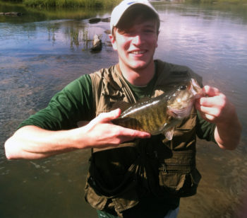
Quint Rogers with a shoalie
Shoalies have excellent sporting qualities, hitting hard and fighting hard, with frequent jumps, readily taking artificial lures presented on casting and fly tackle.
Fisherfolk who wade, kayak, use jon boats, and operate high-powered bass boats all target the species, and tournaments typically won with stringers of largemouth bass have seen the bacon taken home by a savvy shoal bass angler who ran far above flat reservoir water to target this lover of fast-running water.
Georgia is home to the highest black bass biodiversity in North America primarily due to its many types of running water in over 70,000 miles of creeks, streams and rivers. Home to the world-record largemouth bass (Georgia’s state freshwater fish), the state draws anglers from all over the planet to the variety of fish offered by so many types of water. Shoal bass are very special among this pantheon of fine game fish.
Now, Georgia Wildlife Federation and Flint Riverkeeper are supporting a bill in the Georgia General Assembly (House Bill 483) to declare the shoalie Georgia’s official native riverine sport fish, honoring the species itself and highlighting the importance of undammed, clean, flowing water to support the shoalie and Georgia’s fishing economy, heritage, and culture.
The teamwork by American Rivers, Flint Riverkeeper and other partners to restore and protect habitat and healthy flows in the upper Flint River is critically important to maintaining a robust shoal bass fishery and the economic benefits it creates.
As goes the Flint, so go the creatures who call it home… among them the shoal bass, one of the planet’s finest game fish.
Our work to remove dams and restore rivers often hinges on more than a single issue. Nowhere is this truer than our efforts to remove the Bloede Dam on the Patapsco River in Maryland. While the primary driver for this restoration effort is the opening of more than 65 miles of spawning habitat for migratory fish, safety and the need for ongoing maintenance are just as critical at this site.
Removal of the Bloede Dam is an investment in Maryland’s future. It solves a critical infrastructure issue that has plagued the state since at least the 1980’s— costing Maryland millions of dollars in repairs, studies, and staffing over time. If the dam remains in place, the cost of repairs needed to comply with Maryland Dam Safety requirements could exceed $1 million. Removing the Bloede Dam enables the restoration of a natural, resilient river system and eliminates any future financial obligations by the State for repairs and long-term maintenance.
Located within the Patapsco Valley State Park, one of the most popular state parks in Maryland, the dam is also an attractive nuisance that has played a significant role in more than nine deaths and untold injuries since the 1980s, including two in the last two years. Despite signage and regular patrols by Maryland Park Service staff, many summer visitors ignore the posted warnings and continue to put their lives in jeopardy.
Thankfully, the National Oceanic and Atmospheric Administration, the U.S. Fish and Wildlife Service, the National Fish and Wildlife Foundation and others have invested more than $8 million to restore the Patapsco River (including earlier removals of the Simkins and Union dams). Removal of the Bloede Dam is the key to realizing the benefits of this comprehensive watershed restoration effort.
Maryland State funding is also critical to implementing this project and eliminating future state liability associated with the dam, and this funding is currently in jeopardy. The Maryland General Assembly is considering the Budget Reconciliation and Financing Act of 2015, which includes cuts to the Maryland Department of Natural Resources’ budget that will mean the loss of $1 million previously allocated to remove the state-owned Bloede Dam. Governor Hogan committed to ensuring the funding is available in a recent Bay Journal article; however, funds must be reinstated in the budget to ensure that funding remains dedicated to the Bloede Dam removal.
In a recent 5280 magazine article, Kate Siber asked, “Can a Water Plan Actually Work”? At times she came close, but never really answered her own question. The answer is a solid “it all depends”.
The Colorado Water Conservation Board (CWCB) Director James Ecklund and his staff have put a tremendous amount of time, effort and political capital into the fledgling Colorado Water Plan. So have the nine Basin Roundtables and the Inter-Basin Compact Committee (IBCC). So have the thousands of people from all around the State who have been engaged, submitting comments and learning more about how water “works” in Colorado.
With support like this, how could the Water Plan fail? Well, that depends.
The success of the Colorado Water Plan depends on the sincerity and willingness to abide it receives from the established water community. When work on the Plan began, some detractors replied that Colorado already has a water plan. It’s called prior appropriation. And they are right, for the most part.
The Colorado Water Plan is an advisory document. It is a blue print for how we should manage water for all our needs, but it has no force of law behind it. Like a County Master Plan, it provides guidance for the future based on how we see it today. In Colorado, while the people own the water itself, the right to use it is an individual property right that can’t be abrogated without due process.
So the Water Plan falls back on how much people, especially people who make decisions about water use and development, respect it. The State does have some permitting authority for water projects, as do local County governments. The State also has considerable funding capacities for water projects and efforts such as the Roundtables. These can provide powerful incentives for project proponents to comply with tenets of the Water Plan, but only to the degree that decision makers continue to support the Plan.
Whether the Colorado Water Plan works or not boils down to a matter of faith – faith in our institutions to do the right thing. Change doesn’t come easy, but it will come. How we shape that change using guides like the Colorado Water Plan is how we shape our future. James Ecklund, in Kate Siber’s essay, echoes a common sentiment that “If we keep doing things the way we’ve done them for the past 100 years, we will be in trouble.” That’s putting it mildly.
No one expects the doctrine of prior appropriation to go away, but changes will be needed, especially if we want rivers and watersheds to be healthy and resilient while keeping productive agriculture and growing communities “vibrant”. Times and values have changed since 1876 and we need to understand that.
The changes also need to be in how we’ve traditionally provided for water in the past through more storage and more diversions from one side of the Continental Divide to the other. The past is no longer a guide to the future. We need a new water paradigm for Colorado, a new way of thinking that looks more towards conservation, efficiency and 21st century technologies.
Other places with climates similar to or even drier than ours have gone in this direction. It is amazing how much the Israeli’s can squeeze from a drop of water! Doing this in Colorado will require changes in laws, traditions and practices; and that will not come easy for some.
If the Colorado Water Plan is going to work we will need to use it, not as a roadmap from the past but as a creative guide for the future. It will also take substantial goodwill and cooperation among all the users and uses we have for the scarcest of western resources, water.
As someone who lived through the worst oil spill disaster in American history, I’m going to tell you an unpleasant truth – oil spill cleanups are a myth.
I was among the thousands of workers who were hired to clean up the 11 million gallons of North Slope crude that hemorrhaged from the Exxon Valdez when it ran aground in Alaska’s Prince William Sound on Good Friday in 1989. During my first stint on the spill cleanup, my crew of 200 workers was hired on a Friday and fired the following Monday. A USA Today crew was helicoptering out to one of the hardest hit beaches for the weekend, and Exxon wanted to show the American people that it was doing everything possible to clean up its mess.
A quarter century later, you can still find oil along that remote coastline by digging down a few inches into the gravel. Despite enlisting 10,000 cleanup workers, 1,000 boats, 100 aircraft and spending $2.1 billion over a period of four years, Exxon was able to clean up just ten percent of the spill. Most experts say the cleanup effort did more harm than good.
The cleanup tally was even worse when Exxon’s Silvertip Pipeline spewed 63,000 gallons of oil into the flood-swollen Yellowstone River by Laurel in July 2011. Despite spending $130 million on the cleanup, less than one percent of the oil was recovered.
So imagine how successful Bridger Pipeline LLC will be in cleaning up the 40,000 gallons of Bakken crude that gushed into the Yellowstone River by Glendive when its Poplar Pipeline ruptured on January 17. At the peak of the cleanup, a company spokesman told the Glendive Ranger-Review that it was recovering one teaspoon of oil every ten minutes from holes that it cut in the ice. At that pace, it would take 1,753 years to clean up the spill.
It wouldn’t be fair to blame Bridger Pipeline for its inability to clean up the spill. After all, the surface of the river was frozen solid for 20 miles below the ruptured pipeline, and a swift current was carrying the oil underneath the ice towards North Dakota. It’s doubtful that more than five percent of the oil could have been cleaned up even under optimal conditions.
But it is fair to blame Bridger Pipeline, and the federal agency that oversees pipeline safety, for not preventing the spill in the first place. When the Poplar Pipeline was last inspected in 2012, it was buried just eight feet under the bed of the Yellowstone River. That’s four feet deeper than the minimum depth required by the Pipeline and Hazardous Materials Safety Administration (PHMSA). A large, dynamic river like the Yellowstone can scour twice that depth in a single flood event.
So it should have come as no surprise when investigators discovered that 120 feet of the Poplar Pipeline was totally exposed following the spill. It was an accident waiting to happen. And you can bet there are scores of other ticking time bombs lurking in the 18,000 places across the country where pipelines cross under rivers, streams and lakes.
Since it is virtually impossible to clean up oil once it’s spilled into our waterways, our focus must be on spill prevention. While the energy industry will complain about the cost, we need to demand common sense safety measures like burying pipelines much deeper under rivers, constructing them with thicker steel, requiring automatic shut-off valves, mandating more frequent inspections, and dramatically increasing fines for acts of negligence. Failure to implement these measures is an invitation to more oil spills, more contaminated water supplies, more sickened people, and more fish and wildlife kills.
Better yet, we should accelerate our nation’s transition away from dirty fossil fuels and toward cleaner, safer renewables like wind and solar. For as it’s been said, when there’s a major solar energy spill, it’s called a nice day.