Polluted runoff is a major source of pollution for the Chesapeake Bay. The Chesapeake Bay Total Maximum Daily Load (TMDL) allocations were set as pollution caps that have an accompanying implementation plan that will ultimately restore the Bay’s water quality. All communities within the Chesapeake Bay watershed are subject to the Chesapeake Bay TMDL allocations. One way that communities are reducing their polluted runoff is by installing green infrastructure.
Urban agriculture is an innovative green infrastructure practice that can be implemented in vacant city lots. Urban agriculture not only reduces stormwater runoff but it also increases the nutritional health of the surrounding community, improves the local economy, and provides residents with greenspace.
American Rivers recently released a report entitled Urban Farms: A Green Infrastructure Tool for the Chesapeake Bay that discusses the benefits provided to waterways and communities when urban agriculture is used as a stormwater mitigation practice. The report recommends ten things that cities can do to help promote the use of urban agriculture as a green infrastructure tool.
- Provide training and education for urban farmers through accessible workshops on best stormwater management practices. Best practices will help cities meet their stormwater management goals.
- Identify viable vacant lots to be converted for the purpose of urban agriculture. Cities can determine which sites are best for agricultural practices and work with urban farmers to create site plans to meet the city’s requirements, reduce runoff, and grow sustainable crops.
- Eliminate the barriers to purchasing or obtaining a long term lease of a vacant lot. Allowing farms to make a long term commitment will open the door to more funding opportunities. Funders prefer to invest in opportunities that will continually improve the surrounding watershed.
- Offer farmers access to funding opportunities for the incorporation of green infrastructure. Cities can create grant programs, offer guidance on the application process, or communicate existing opportunities.
- Allow a tax credit for farms that include green infrastructure into their farm design. Many cities offer tax credits to home owners who install rain barrels or gardens in their home because it helps the city meet their stormwater goals. Urban farms should be encouraged to implement rainwater capture and re-use systems through this type of incentive.
- Include urban agriculture as a permitted use in city zoning code. Many cities do not address urban agriculture in their zoning codes, making it seem that it is a prohibited use of land. Listing urban agriculture as a permitted use shows the city is supportive of efforts to provide neighborhood access to healthy food and create greenspace.
- List stormwater management as a benefit or definition of urban agriculture. Urban agriculture can be an effective green infrastructure practice. Identifying the stormwater management benefits of urban agriculture helps increase acceptance and adoption of urban agriculture and ensure that urban farms contribute to municipal stormwater management.
- Require urban farms to develop a stormwater management plan if they increase the amount of impervious surface on the lot. Placing structures on vacant lots, such as hoop houses, may actually increase the lot’s impervious surface and create increased runoff. Some cities and farms address this problem by incorporating water re-use systems that collect runoff from structures and re-use in plant production.
- Require soil tests and a nutrient management plan if using soil amendment. Whenever nutrients are added to the soil, it is important to conduct soil tests to determine how much is actually needed and continue to monitor the addition to avoid runoff into nearby streams and storm drains.
- Continue communication with the farms to ensure they are compliant with the city’s urban agriculture ordinance. Creation of an urban agriculture working group enables farmers and city officials to address barriers to urban agriculture and determine new farming policies to address those barriers together.
For a more in depth look at these recommendations please read Urban Farms: A Green Infrastructure Tool for the Chesapeake Bay!
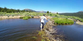
“Four point six feet,” I say, pulling a stadia rod out of the water and back onto the inflatable kayak, “but I think it’s deeper over there.”
I’m measuring the depth of a beaver pond in a Sierra Nevada meadow that American Rivers is restoring this summer. I paddle upstream a few yards, struggle for a moment with the rod and the current, and call back, “seven feet!”
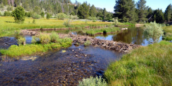
Meanwhile, Austen takes measurements at the two beaver dams spanning the river. Combined dam length? 132.2 feet. Dam height? 2.2 feet. Fish present? Yes, abundantly.
Beavers are well known for building dams and ponds, but many people don’t realize how much they benefit the landscape and our own quality of life.
Beaver ponds slow water and give it a chance to sink into the ground, where it can recharge aquifers and provide base flow for streams and rivers during dry periods, improving our access to water when we need it most. Those pools also make excellent habitat aquatic bugs, fish, and numerous other species.
The ponds flood during higher flows and spread water further, increasing wetland area and letting even more water sink in. Larger wetlands means more habitat for plants like willow and aspen, which in turn make more habitat for many bird species, including the threatened willow flycatcher.
Perhaps best of all, the dams catch sediment as it travels downstream. Much of our work in restoring meadows centers on reversing erosion in stream channels. Beaver dams can rebuild an eroded stream channel with new sediment, and transform it into a healthy meadow again over time. In other words, Beavers do our meadow restoration work for us, for free.
The North Pacific Landscape Conservation Cooperative just released a comprehensive beaver restoration guidebook, written by scientists from the US Fish and Wildlife Service, NOAA, the US Forest Service, and Portland State University.
Some people raise concerns that dams block fish and other species from moving up and down rivers. Fortunately, beaver dams don’t function like a concrete or earthen dam, and tend to benefit fish more than harm them. Beaver dams are porous, allowing smaller fish to squeeze through, and they create side channels or overflow easily in high water, allowing larger species like coho salmon to pass most of the time.
Despite all the benefits beavers and their dams have on wetlands and streams, Beavers have had a rough time in California. Before the California gold rush, a wave of European fur trappers with the British-owned Hudson Bay Company swept through the Sierra Nevada beginning in 1821, intent on denuding the land of all furbearing mammals so that the Americans would have “no inducement to proceed hither.” They were so successful in trapping out beaver in the region that 115 years later Joseph Grinnell, a preeminent California zoologist, mistakenly considered the large rodents to not be native above 1000 feet in the Sierra Nevada. Since then, land managers and government agencies in the region have typically classified them as a nuisance species at best and even sometimes as a full on invasive species.
Recent evidence for beavers in the Sierra Nevada, including a buried beaver dam carbon-dated the year 580 AD (±60 years) and a review of historical records, make it clear that the animals did inhabit much of the mountain range before the fur rush . Unfortunately, policy and public opinion are slow to adapt to the new information. California Fish and Game Commission doesn’t set any limits on the number of beaver that can be trapped in the majority of the state, and it is illegal to relocate nuisance beavers in California. Many people still resent the animals, and go out of their way to remove them.
Continuing down the river, we come to four foot high dam–with a fresh gaping hole torn through the middle of its forty foot length. Fish still take refuge in the shade of the dam, and it still holds back some of the sediment flowing downstream, but it’s easy to see where the water recently swelled past the river banks and far onto the meadows on either side. The pool, the active wetlands, and the sustained summer flows on the river all washed downstream when someone breached that dam.
It’s true that beavers, with their engineering prowess, can cause serious problems for people. They plug culverts, flood fields, roads, and houses next to streams, and cut down favorite trees.
The thing is, humans are excellent engineers too, and with all the ways that beavers benefit us and our environment, we have better ways to deal with them than extermination. Simple measures can protect culverts and individual trees, and devices can control the level of beaver ponds to prevent flooding. As long as we can outsmart them, we can reap the benefits of beavers and their engineering without damage to our own constructions.
Finishing our survey, we come across many more dam remnants from years past and one more active beaver pond. As we work to restore the ecological function of this meadow, and many others, it’s important to remember that we’re not alone. Beavers might not care about improving the quality of life for people downstream, but they restore meadows like their lives depend on it, anyway.
A hot, dry summer and lack of winter snowpack are causing severe hardship for the Yakima River basin’s fish and farmers this year, but the basin’s long-term outlook just got a lot brighter.
First, on the final day of June the Washington State Legislature agreed to allocate $30 million in state funding to the Yakima Basin Integrated Plan over the next two years. This funding will allow for construction of adult fish passage at Cle Elum Dam, a study of fish passage at Tieton Dam, final design of the Kachess Drought Relief Pumping Plant, and $10 million worth of fish habitat restoration and water conservation projects.
Then, on July 1st, Sen. Maria Cantwell introduced S. 1694, the Yakima River Basin Water Enhancement Project Phase III Act of 2015. The bill, which received a hearing before the Senate Energy and Natural Resources Committee on July 7th, authorizes the first 10-year phase of the Yakima Plan. The legislation is co-sponsored by Sen. Patty Murray.
Highlights of the plan’s first 10-years include:
- Fish passage at Cle Elum and Tieton dams;
- Lake Kachess Reservoir Drought Relief Pumping Plant, with construction and operation financed by water users rather than taxpayers (no other surface water storage projects are authorized by the legislation);
- 85,000 acre-feet of water conservation (that’s nearly three Bumping Lake reservoirs worth of water saved);
- Habitat restoration projects including mainstem Yakima River floodplain restoration, meadow restoration in the Teanaway Valley and elsewhere, barrier removals, and projects to get roads out of floodplains;
- Groundwater storage projects that will provide cooler, more plentiful streamflows and reduce the need for new surface water storage;
- Enhanced water markets; and
- Protection of 50,000 acres in the Teanaway River Valley as a Community Forest (already accomplished) and designation of the upper Cle Elum River system as Wild and Scenic (to be accomplished through separate legislation after working with local communities to finalize a river protection plan)
The end result of these actions will be abundant salmon and steelhead runs, including a large sockeye salmon run, better instream flows for trout fishing and boating, healthier riparian areas for wildlife, and a more reliable water supply for farms and communities – even in the face of the local impacts of climate change.
It’s worth highlighting the commitment of irrigation districts and other water users to finance the construction of the Kachess pumping plant on their own. This laudable approach means water users will need to calculate for themselves the value of additional drought year water supplies, and it removes the kind of artificial taxpayer subsidies that led to many regrettable water projects in the 20th Century.
Take a minute (or 60) to watch the July 7th hearing – as Chairwoman Murkowski noted, it’s not often you see representatives of an irrigation district, a Native American Tribe, American Rivers, and state and federal officials in such close agreement on major water and fisheries restoration issues.
And while the Yakima River Basin is solving its water problems without resorting to the out-of-basin water importing schemes of the past, other river basins around the western U.S. would be wise to import the Yakima Basin’s collaborative, pragmatic approach to solving challenges facing fish, rivers, farms, and communities.
This week, Oregon Senators Wyden and Merkley along with Representatives DeFazio(OR) and Huffman(CA) lead the charge towards protecting the highest concentration of Wild and Scenic Rivers in the contiguous United States.
The Smith, Rogue, and Illinois Rivers are threatened by proposed industrial nickel strip mining that could decimate these remarkable watersheds. The delegation, the Bureau of Land Management, and the Dept. of the Interior have all taken actions to protect these threatened areas.
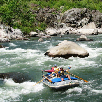
Whitewater rafting on the Rogue River, OR
The sought after protections can get a little tricky. The delegation of Wyden, Merkley, DeFazio, and Huffman introduced The Southwestern Oregon Watershed and Salmon Protection Act of 2015 (H.R. 682 and S. 346) earlier this year. This legislation would permanently protect these deserved lands, but it takes time. Meanwhile, the foreign owned company with two of the three mining claims wants to move forward.
Federal agencies stepped up with a temporary ban and a public process to consider a 5-year ban on new mining while Congress considers the introduced legislation. This ban would prevent new mining claims and require proposed mines to meet a rigorous review process.
According to the EPA, the metal mining industry is the largest toxic polluter in the United States. Their report states that 88 metal mines account for 47%(nearly 2 billion pounds) of toxic chemical disposal in America. That is nearly 22 million pounds of chemicals that “cause cancer or other chronic human health effects” per mine.
Abundant salmon, steelhead, cutthroat, and world-renown biologically diverse plant species are not the only dependents of these exemplary waterways. Local communities in Southwestern Oregon and Northern California also depend on these rivers for clean drinking water, recreational and commercial fishing, and a recreational economy that brings hundreds of thousands of dollars to the area each year.
What you can do
This delegation’s continued commitment to watershed and wilderness protection has lead us in the right direction. Now it’s on us to take the next step. These are federally owned lands and therefore are owned by every citizen of the United States.
American Rivers and a diverse group of local partners are developing a Blue Trail for the Ashley River in South Carolina. Guest blogger, Howard Bridgman, former Summerville Town Council member and founding member of the Ashley Scenic River Advisory Council, writes about our work to connect local communities to the river through recreation and finding ways to ensure its long-term health.
Ashley RiverFest attendees got a glimpse of the river’s history as well as the chance to experience some of the ways they and their families could enjoy the Ashley River Blue Trail right now.
The RiverFest was held at Jessen’s Landing and Colonial Dorchester State Historic Site on Saturday May 16. Volunteers from organizations throughout our river community pitched in to make sure that everyone had a great time on the river – especially those who were experiencing it for the first time. RiverFest attendees were treated to free kayak or standup paddleboard rentals from Nature Adventures Outfitters, which were generously sponsored by the Oakbrook Civic Association and Mark Facklam, a local businessman who plans to start a livery on the Ashley River. For those who wanted to take a more leisurely approach to exploring the river, members of the Oakbrook Rotary Club were offering power boat tours. All four power boats were busy all day, and more than 100 people opted to try a paddling adventure.
New groups and participants added new energy to the event, which doubled attendance over last year’s records. The Charleston Waterkeeper and Berkeley County Blueways set up displays to share news about their important conservation work. Attendees also saw performances from Edisto Indian dancers, story-telling by the Gullah Lady, the B.E.A.U.X. Hawks Drum Corp, and H.L Hunley Traveling Exhibit of the famed Civil War submarine.
Visitors were also treated to a glimpse of the river community’s history. Colonial Dorchester State Historic Site Manager Ashley Chapman organized an exhibit of colonial-era life that let visitors tour a Revolutionary War encampment, see troops in period uniform, and explore the daily lives of colonial era residents. The event also featured hourly demonstrations of cannon fire by the Second Company of the Georgia Artillery.
Looking forward, American Rivers is in the process of creating a paddler’s map of the river that will highlight access points, currents, sight-seeing landmarks as well as insight into some of the rich history of the river. Find more rivers to explore at bluetrailsguide.org
When you think of the Mississippi River, what do you think of? Do you think of mile long bridges over a glassy surface? Do you think of deep water teaming with giant catfish? Do you think of levee breaches and houses on stilts? Do you think of big barges and Huckleberry Finn? There are a number of images that come to mind when the Mississippi River is invoked, but one image people rarely relate to the Mighty Mississippi is white water rapids. And that was the image introduced by Ron Way and Steve Berg in the Star Tribune last week.
Their story sparked a lot of imagination and dialogue about the future of the Mississippi River post-commercial navigation. And it’s a conversation we absolutely must have as the Corps of Engineers starts looking at the future of their infrastructure around the nation. Too often, the Corps has walked away from their responsibilities, like the Hennepin Canal in Northern Illinois. That Canal was built to provide a short-cut between the Illinois and Mississippi Rivers. It was over 100 miles long and open for less than 50 years. Almost as soon as it was built, it was obsolete as barge configurations had already outgrown the infrastructure. What did the Corps do when it was closed? Walk away.
I’ve spent a lot of time in Minneapolis, talking to different groups about the future of the Mississippi River through their downtown, and while not everyone is on board with Restoring the Gorge (yet) everyone does agree that the Corps will not walk away from their infrastructure. They built it and drowned the only remaining big river rapid on the Upper Mississippi River, decimating important habitat for many species. If the infrastructure won’t be used for commercial navigation, than it needs to be removed or altered to restore the rapids.
Oh, and a white water park for kayaking, rafting and fly-fishing will be sweet too. A dam removal on the Kickapoo River in Wisconsin sparked a recreation industry that now generates $1.2 million annually. So, just think of the revenue that the restoration of the gorge would generate in a city the size of Minneapolis.
So what’s next? American Rivers will be hosting a forum this fall with our partners in Minneapolis to discuss how to proceed with the restoration concept. The forum will try to answer questions about the project, like invasive species concerns, and identify the many barriers that stand between Minneapolis and its wild river. I hope you can join us.
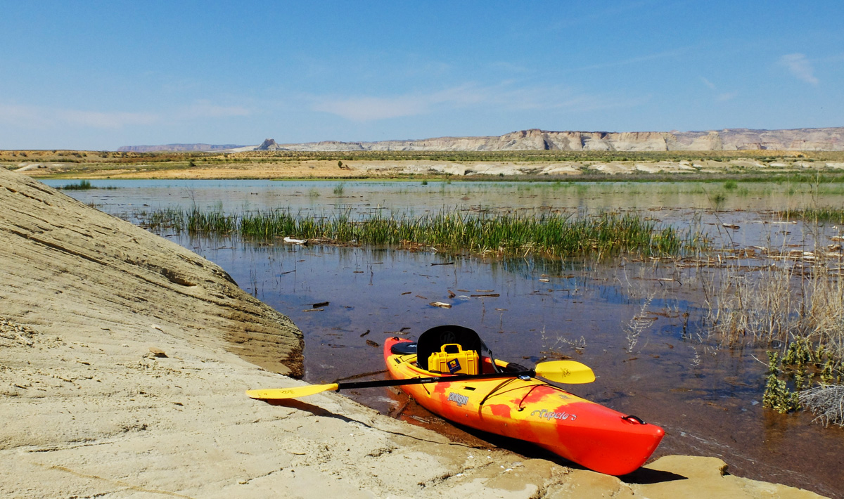
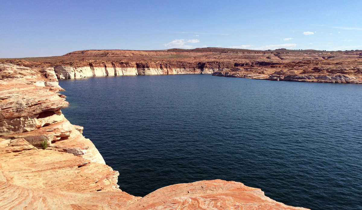
Sweat is draining down from under my sun hat, drenching my shirt – and I’m not even working! Simply bobbing along in my bright orange sea kayak, out on a massive, man-made reservoir in the middle of June is enough to wick the hydration straight out of my cells.
I had come west from the cool mountains of Colorado to this place, Wahweep Marina on Lake Powell in northern Arizona, with a New York-based film crew to make a short piece on the drought, overuse of the Colorado River, and what solutions might be possible to put water back into this river and work towards a sustainable future in the southwest. We have a pair of kayaks, a half-dozen cameras and booms and gimbals and even a small drone to illustrate what the levels in this lake, and the heat, are telling us all across this arid region.
Just days earlier, Lake Mead, the other giant reservoir 280 miles downstream that, together with Powell, bookends the Grand Canyon, had reached a critically symbolic and important milestone – it’s elevation had dropped to below 1,075 feet – the level at which, if it were to remain at or fall even further by the beginning of 2016, the US Bureau of Reclamation would be forced to perform an in-depth analysis of the future of water supply in the southwest. This could result in dramatic cutbacks, affecting people, agriculture, and wildlife in the region – most notably here in Arizona. These painful and drastic measures, though, may be what is required to start pulling this part of the basin back from the brink.
But this reality is already before us, whether the elevation in Lake Mead is sitting at 1,075, or 1,090, or 1,055 – the Colorado Basin is over-tapped, over-used, and stretched thin. Action must be taken now, and everyone from all walks of life in the southwest must lend a hand.
Here on Lake Powell, the situation is easy to see – the contrast painted across the towering walls between the rusty sandstone caps and the pearly-white “bathtub ring” is stark. At about 50 feet high, the mineral deposits left from the shrinking lake tell a story of overuse, of drought, and of a warming climate, that together are creating a perfect storm that must be addressed with thoughtful and sustainable solutions. Fortunately, those solutions are ready, proven, and available – we simply need the will to put those solutions in place, and sooner than later.
But first – I need a drink. Its 104 degrees out here – the sun is simply relentless and the breeze nonexistent. Like all systems, sometimes you have to put some water in to make them work right – without it they break down. Your body must conserve, be efficient, and not waste its vital hydration to stay fit and keep working, moving forward. Simply storing more won’t work if the entire system is out of alignment.
In the Colorado Basin, we know that there are a number of things that can make a world of difference. First, cities and municipalities can have a huge impact by conserving water and being more efficient. Additionally, every city and town in the basin can find ways to reuse water, whether it is supplying gray water to urban landscapes and parks or going so far as cycling that water through the municipal water supply system. Next, we need to implement ways to help agriculture become more efficient and more importantly, increasingly sustainable in the face of all the challenges that farms and ranches across the west constantly face. They grow our food and provide much of the cultural and historic spirit of the southwestern US. Lastly, we have an opportunity to move our energy consumption to more renewable sources, like solar and wind, which have significantly less demand than the water needs of cooling coal-fired or natural gas generating stations, or for the exploration of natural gas or shale. The transition to renewable energy sources is a transition that saves an abundance of water.

Living in the southwest is an honor that about 35 million people get to enjoy and prosper. From the wide-open spaces, to the clean air and an abundance of outdoor activities, to the food that is grown for an entire nation, all of us are lucky to call this region home. But with that comes a responsibility to make it work for all of us, AND the river and the people and wildlife that depend on it at the same time.
Right now, I need to get a big drink before I head back to my dock – passing out from the heat and lack of water out here is not an option.
We all enjoy the dynamic, exciting, and life-giving abundance that this river provides for us – let’s lend a hand to help give back to the river that takes such good care of us, and let’s start doing that now.
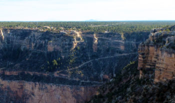
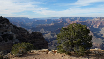
By now, you may have heard about a scheme to build an amusement park-style gondola from the East Rim of the Grand Canyon, plunging 10,000 people per day down to the Confluence of the Colorado and Little Colorado Rivers. On the rim of the canyon, a small town would be built to support the tourist traffic, while over 30,000 square feet of structures, including a pair of elevated steel walkways, a small restaurant, bathroom facilities and more, would be built mere yards above the river itself. On a recent broadcast of the Diane Rehm show, a representative of the project proponents argued that there are not enough opportunities for people, especially the elderly, young, or less fit to experience the Grand Canyon.
This idea is simply flawed – there are already a myriad of ways for anyone – rich or poor, able-bodied or disabled, American or foreign, to experience and enjoy the amazing, iconic, natural wonder of the Grand Canyon. The Grand Canyon provides a world class visitor experience, and nearly 5-million people per year will attest to that fact. As a World Heritage Site and one of the seven natural wonders of the world, the Grand Canyon is a place deserving of protection and enjoyment without more intrusion by man – as nature intended it:
A hike – along the rim or to the bottom
Bright Angel Trail
One of the simplest and most rewarding ways to experience the grandeur and natural expanse of the canyon is to lace on a pair of boots and hike the canyon.
Whether you plunge into the world below the rims, or meander the miles of dirt and paved trails skirting the canyon walls, plenty of options exist for hikers of any skill level.
Even if time doesn’t allow a hike all the way to the river, there are a variety of trails that lead you off the rims and into the abyss in only a few steps. In fact, programs exist today that have led blind, deaf, or otherwise disabled youth into the wilds of the Canyon. If these kids can do it – so can you!
Ride a mule
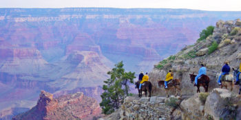
Riding mules into the Canyon
From either the North or South Rim of the canyon, mule trips as short as an hour to as long as two days exist for those who may not want to hike the trails, or for those who simply want a different kind of experience – old west style!
Mules have been traveling the trails from the rims to Phantom Ranch for over a century and provide a sure-footed, unique, alternative experience to hiking that is an adventure on its own!
Soak in the view from the rim
View from the rim
For those who have no desire to venture below the rims, simply soaking up the spectacular view, the clean mountain breezes, and the soaring condors, hawks, and ravens cruising the skies can be a peaceful, calming, and rewarding alternative to a more physical adventure.
On nearly every visit, you will find painters and artists, photographers and writers, contemplating the landscape, the brilliant light, and the spectacular expanse – from the rim of the canyon. The light and air and silence and sky that one can absorb simply by sitting on a bench or rock or under a tree is a humbling and awe-inspiring experience.
Float the mighty Colorado River
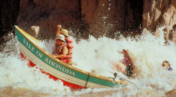
Riding a dory on the Colorado River
There are a wide array of rafting options available for people who have the time and adventurous spirit to experience a true wilderness getaway in the bottom of the canyon.
From as little as 3 days to as many as 28 days, there are a number of companies who offer commercial trips, as well as a community of private boaters who experience the canyon on the river’s terms – staring upwards at ramparts of rock by day, majestic starry skies by night.
Take to the skies
While certainly not my most preferred way to view the canyon, more modern technological ways to view the canyon do already exist. There are a variety of aircraft tours at both ends of the canyon – whether by fixed-wing airplanes or by helicopter, that cruise the skies overhead across the main canyon, as well as over side canyons, forests, and the desert plains that surround Grand Canyon National Park. Another, ground-based option is the Grand Canyon Skywalk on the west end of the canyon. Accessible by road from the north or from Las Vegas, the glass-floored Skywalk structure on the Hualapai reservation is one way to experience heights in the canyon by peering between your own two feet.
There is a variety of ways that anyone and everyone can currently enjoy and experience the Grand Canyon – and whether you choose to walk or ride or float or fly – you too can take part and enjoy our nation’s most iconic National Park. The Grand Canyon doesn’t need yet another man-made, technological solution to fix a problem that doesn’t even exist.
Now get your map out and get going!! The canyon is awaiting your visit!
The Black Warrior River — listed as one of America’s Most Endangered Rivers® of 2013 and 2011 — is the subject of this update from guest author Charles Scribner, Executive Director of the Black Warrior Riverkeeper.
Friday, June 19, Black Warrior Riverkeeper received inquiries from several reporters about a press release that Drummond Company had just sent to them related to their interest in the Shepherd Bend Mine. Drummond’s press release stated that they will not renew their permit to mine coal at Shepherd Bend. Needless to say, that was a very important announcement for the river, the people who enjoy it, and the 200,000 people in the Greater Birmingham area who receive their drinking water from the Birmingham Water Works Board’s intake across from Shepherd Bend.
This appears to be fantastic news for water consumers, however, lacking certain key details, including whether this decision is permanent, it would be premature to declare victory. Even if Drummond is permanently shelving its plan to mine at Shepherd Bend, we must keep the pressure on The University of Alabama to promise that they will never sell or lease their land or mineral rights to any mining company at Shepherd Bend. Our opposition to mining at Shepherd Bend was never specifically focused on Drummond, and if another company ever showed interest in Shepherd Bend, we would mount the same opposition.
The University of Alabama is still the major owner of land and mineral rights at the proposed Shepherd Bend Mine site across from a major drinking water supply area on the Black Warrior River’s Mulberry Fork. We have been partnering with American Rivers to battle this potential coal mine for a few years now. The university has a great opportunity to do the right thing NOW, and declare the Shepherd Bend site permanently closed to coal mining prospects.
We will continue to monitor the situation. We deeply appreciate American Rivers’ help with this issue, and ask that our tens of thousands of partners on this issue continue to stand with us in opposition to harmful coal mining at Shepherd Bend. To stay updated, please visit this page: www.blackwarriorriver.org/shepherdbendmin
The Black Warrior Riverkeeper is a citizen-based nonprofit organization dedicated to improving water quality, habitat, recreation, and public health throughout the Black Warrior River watershed.
That image is the Catawba River, North Carolina. A hydropower project owned by Duke Power. The project has been operating on an annual license after its existing license expired in 2008. That is supposed to be a waterfalls.
What if the old hydropower dam that is killing fish and drying up your local river could be improved and brought up to modern environmental standards? What if there was a way to get the dam owner to release more water into the river, provide public access to recreate on the river, or help fish to swim past the dam safely?
Good news: there is a way to fix outdated dams. Every 30-50 years, the energy corporations that own the nation’s hydropower dams must get a new operating license from the federal government. When they do, we have a once-in-a-lifetime to bring these dams up to modern environmental standards. States can require dam owners to meet water quality standards. Federal fisheries and wildlife managers can require them to install safe fish passage facilities and protect endangered species. And the agencies that manage our public lands can require them to put water back into rivers so that you and I can fish, boat, and swim again.
Over the past three decades, American Rivers and our partners at the Hydropower Reform Coalition have used the licensing process to improve the operations of hundreds of hydropower dams and restore thousands of miles of river. In making these improvements, the hydropower industry has gone a long way towards rehabilitating its past legacy of environmental damage.
However, if the hydropower industry gets its way, these opportunities could be lost forever. Two industry-supported bills in Congress would largely would allow the hydropower industry to not have to comply with the Clean Water Act, the Endangered Species Act, and other basic requirements for providing fish passage and protecting public lands. Senator Lisa Murkowski’s Hydropower Improvement Act of 2015 (S. 1236) and the discussion draft proposed in the House Subcommittee on Energy and Power would turn back the clock and take the hydropower industry back to a time when they could destroy rivers with impunity. Neither Senator Murkowski’s “Hydropower Improvement Act” nor the House Subcommittee’s discussion draft improve anything except for energy corporation’s profit margins.
These bills would:
- Allow energy companies to opt out of Clean Water Act, Endangered Species Act, and state water quality and wildlife protections.
- Let dam operators pass to taxpayers the costs and burdens of obeying water quality standards and wildlife laws and cleaning up pollution caused by the dams.
- Ignore modern environmental laws and let dam owners operate under 1950’s era rules — even if it means dead fish and dried up stretches of river.
- Strip states and tribes of their authority to hold hydropower dam owners accountable to water quality laws.
- Transfer the authority to protect natural resources away from the state and federal agencies that manage those resources to Federal Energy Regulatory Commission, a virtually unaccountable energy-permitting agency in Washington, DC.
- Make local communities responsible for all the costs and burdens of obeying water quality and wildlife management rules when dam owners don’t follow the law.
- Let anyone, regardless of their qualifications, build hydropower (up to 5 MW) on an existing dam without first proving they won’t pollute the drinking water or put local residents at risk.
The industry says that these provisions are intended to “modernize” hydropower regulation, but I find it hard to understand what is modern about eliminating basic protections for fish, wildlife, clean water, and outdoor recreation. These bills are so damaging that the Obama Administration, many states, and dozens of conservation groups have spoken out against them.
If these bills were to become law, many improvements we have made over the past decades could be nullified. We could lose the opportunities we’ve gained to paddle the world-class whitewater on the Cheoah river in North Carolina, or fish on the Boardman River in Michigan.
These bills would allow energy corporations to get out of having to comply with the laws that protect our rivers and water. Federal hydropower licenses give these companies the exclusive right to profit for up to half a century off of these public resources. As a condition of that extraordinary right, companies should be required to protect those resources for current and future generations. I don’t understand why an industry that has spent so much time and money trying to portray itself as a clean, green source or renewable energy is so determined to opt out of its responsibility to protect the environment. If these bills pass, the only thing “green” about hydropower will be the money flowing into dam owners’ pockets at the expense of America’s rivers.
I had the good fortune to be the son of a man who loved nature. He brought me up fishing and hunting, and when those were out of season, he would take me on long walks in the woods. Seeing a deer through the trees, a hawk circling overhead, or a trout holding in the current was always worth stopping our conversations to take notice.
When I was young, he carried me on his shoulders through rough water. He taught me how to fish just like his dad had taught him. He showed me how to find our way back by measuring the angle of the trees’ shadows to the direction we were walking. And when a proposed dam threatened to destroy a wilderness preserve that we loved, we talked about how we could raise our voice against it.
After initially working in the corporate world, he spent the last half of his career working for the Environmental Protection Agency. He was so proud of how their efforts protected what was so important. It is no coincidence that after years working for a large corporation, I ended up at American Rivers, doing what I can to protect what he showed me was precious.
So on this Father’s Day, I will be remembering his influence, his long stride through the woods, and his broad grin when holding a trout in a small stream.
Hoping to share this with the next generation, this Father’s Day my wife and I will be taking our children backpacking in Yosemite. While they have been on many day-hikes to beautiful places, it will be their first time truly in the backcountry with only those few things they really need. We’ll see meadows, peaks, lakes, and rivers. Their eyes will be opened to how big nature is and how far you can see. And with a bit of luck, they will feel the same connection to the outdoor world that my dad showed me.
The love of nature is a gift that goes in both directions and can keep going as long as we pass it on. Who helped you learn to love being outside? And have you been able to share that with other?
My father and stepmom were river rats, and from a very early age, they introduced me to the mighty rivers of the Southwest.
Many summers we would have more than one trip down the San Juan, and as I got a bit older, I was able to bring friends, girlfriends, buddies to experience this world well off the beaten path. By the time I left for college, I was guiding trips with my university outdoors club on the river that I had explored and contemplated so many times.
We would scramble the side canyons, swim the rapids, jockey for how many skips we could get from that flat rock. There were also many quiet times – moments in the dying sunset where my dad and I would sit and stare at the campfire, contemplating growing up and growing older. I have grainy photos of us sitting on the beach in ratty camp chairs, with a Coors between our legs, just he and I – we were both younger then.
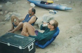
Dad and lad, enjoying a brew – 1995
Fast forward to today.
Over the past year, I have been working with film maker Forest Woodward and author Brendan Leonard to bring Forest’s story of his Dad, a 1970’s-era kayaker in the Grand Canyon, to life on the big screen.
Check it out here:
[su_youtube url=”https://www.youtube.com/embed/ffNPOnbTkmo” width=”1020″ height=”580″]
The Important Places was released in partnership with NRS and Chacos. It won the Most Inspiring Film award at the 2015 5Point Film Festival, and was an Official Selection for this year’s MountainFilm Festival in Telluride.
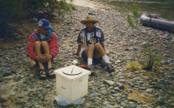
Contemplating the meaning of life – 1995
This heartfelt story pulled me back to the San Juan and the connection that this river creates between my father and me.
Now that my Dad is in his mid-70s, the intersection of these two stories reminds me so much of the special times with my dad and makes me reflect on all of the important places and people I have been lucky to have.
Take a few minutes and watch this amazing piece of work, and think about the important places that connect our hearts, reminding us of those connections that are so vital to each and every one of us.
Then share your story with us. Tell us who helped you remember the value in protecting these places.

