Verde River | Photo by Susan Culp
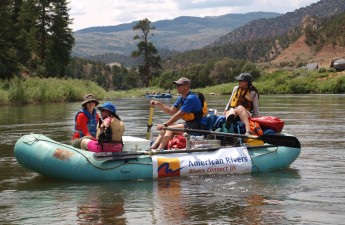
The Verde River is becoming increasingly known as a recreational mecca for outdoor enthusiasts from across the state and around the region. Canoeing and kayaking are common activities, as are fishing, bird-watching, and hiking along the river. Experienced boaters know that the Verde is a small stream, and its flows to support boating are seasonal and may vary considerably depending on precipitation, snowpack, and water removed from the river for agricultural use.
River runners have a number of options to choose from when boating the Verde River. As you know, always checking current conditions before getting out on the river is a wise first step before pushing off from shore. The most consistently floatable stretches during nearly all seasons are listed below; these three stretches are also well suited to novice paddlers:
- Lower TAPCO river access point to Tuzigoot (the Verde River @ Clarkdale stretch)
- The Skidmore Lane river access point to Bignotti river access point in the Prescott National Forest
- Black Bridge river access point to Beasley Flat river access point in the Town of Camp Verde
Boaters are encouraged to enjoy these sections of the river since there are a minimum of hazards and obstacles, as well as reasonably reliable flows even in summertime. The riverside lands along these stretches of river are a mix of private and public lands. Please respect private property rights and only put in and take out at designated access points. Also, check out helpful boater’s guides from our partners at U.S. Forest Service, Verde Valley Land Preservation and Arizona State Parks (special thanks to John Parsons who personally navigated and documented some of these stretches):
- Tuzigoot RAP to the Highway 89A bridge
- 89A Bridge to Beasley Flats
- Wild & Scenic stretch from Beasley Flats to Horsehoe Reservoir
If you are a more skilled or advanced paddler looking for a little more adventure, the Wild & Scenic portion of the Verde River might be right up your alley. Check with the U.S. Forest Service about river conditions, trip size restrictions, and if permits are required for your excursion. The Scenic stretch of the Verde runs from Beasley Flats to Childs River Access Point. Class III and Class IV rapids and hazards along this stretch increase greatly, proceed with caution. From Childs River Access point to Horseshoe Reservoir is the Wild Stretch of the Verde. There is limited access, no services, and only primitive amenities along the Wild and Scenic stretch of the Verde River in order to maintain its wilderness integrity. Please practice leave no trace if you enjoy this section of the river. Enjoy the Verde River – it’s an amazing oasis in the desert!
Verde River | Photo by Doug Von Gausig
This blog was written by Fay Augustyn and Susan Culp.
In 2016, American Rivers worked with communities in the Verde Valley to develop a series of recommendations and resources to develop sustainable river recreation management strategies. Learn more about different management practices in American Rivers’ new report and how they can be implemented in your community.
Download: Best Practices for Sustainable Recreation Management in the Verde Valley
The Verde River in north-central Arizona is a precious gem – a silvery thread that winds its oasis of life through a remote desert environment. One of the last healthy, perennially flowing river systems remaining in the state, it is home to rare cottonwood-willow gallery forests, abundant wildlife, migratory and resident bird species, significant archaeological and historic resources, and vibrant communities. For many years, the Verde River, valued for its healthy riparian habitats and wildlife, has remained relatively unknown outside of the region as a recreational destination. Until now.
The Verde Valley communities of Sedona and Jerome have been popular tourism destinations for decades. The high volume of visitors has meant that over the years these communities have had to work to address visitation issues (such as traffic, housing for service staff, and the encroachment of development on open space). Although the broader Verde Valley has generally remained out of the public eye and undiscovered by tourists, that is rapidly changing.
Across the Verde Valley, there is an array of new initiatives to improve recreation opportunities, foster economic development, and build a healthy economy. The communities of Cottonwood, Clarkdale, and Camp Verde, and the Yavapai Apache Nation, have all engaged in recreation planning in recent years as interest in outdoor recreation continues to rise. Visitation to the Verde Valley is growing, and the residents, spectacular open space, and wildlife are experiencing the effects of these changes.
In this report, we highlight best management practices for sustainable recreation development across the Verde Valley. We also identify successes from communities across the country and what they have done to mitigate the impacts of recreation in river corridors. In addition to identifying practices regarding carrying capacity, education, engineering, and enforcement, we also explore opportunities for their direct implementation in the Verde Valley.
Download: Best Practices for Sustainable Recreation Management in the Verde Valley
Not only will the strategies and best practices in this report help protect the natural environment, they will educate visitors on ways to sustainably support the Verde Valley, surrounding open space, and world-renowned vistas and views. The report includes an appendix that references supplemental information to help communities in the Verde Front and the Verde Valley better understand sustainable recreation management.
While your community may not be exactly the same as those in the Verde Valley, there are valuable takeaways from this report that can be utilized by river towns across the country. Explore them today!
 “Through the Hitchcock Creek Blue Trail, we have renewed a natural resource that will provide paddling, fishing and economic growth through tourism and recreation today and for future generations. Clean, pure water in the middle of an urban area is not often found today and we will preserve this for future uses. The Blue Trail will have a positive influence on other outdoor programs throughout its ten mile run.”
Steve Morris – Mayor of Rockingham, North Carolina
American Rivers helped to transform Hitchcock Creek in Rockingham, North Carolina into a destination for fishing, boating, and other family-friendly recreation. Until 2009, the Steeles Mill dam degraded Hitchcock Creek, blocking migrating fish and preventing the community from safely enjoying the river through recreation. American Rivers and our partners removed the dam, and created a 14 mile Blue Trail.
As part of this effort, the City of Rockingham protected 90 acres of bottomland forest along the Blue Trail, protected 2-miles of riverside land through a conservation easement upstream of the former Steeles Mill Dam site, purchased two river access areas, and acquired a boat launch. Starting in Rockingham, the Hitchcock Creek Blue Trail offers paddlers an opportunity to explore the area’s diverse floodplain forests, historic mills remnants, and rare plants and animals. Rockingham sees their Blue Trail as an economic driver for the region and recognizes that a healthy Hitchcock Creek is vital its long-term success.
Holly Loff
“Rivers have always been at the heart of our family time. And we experience great things there together. We’ve watched goslings attempt their first swim, collected snail shells, caught laughably small fish and admirably large fish together, and so much more. Blue Trails help families like mine more easily enjoy their rivers. Whether through tubing, casting a line, or sitting in a lawn chair and watching the birds, a day on the river is good for everyone. I believe that if people experience their river, they will want to protect it – and our rivers need as many guardians as they can get.” – Holly Loff
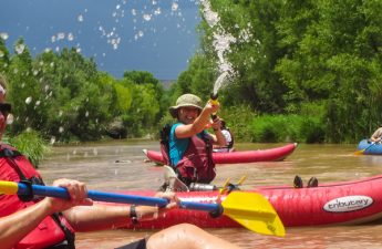
Upper Colorado River | Photo by Jamie Mierau
There are a number of amazing day and multi-day trips along the Eagle Blue Trail on both the Eagle and Upper Colorado Rivers. There is a fit for every level of paddler as well as great access for fishing, hiking and biking along these terrific reaches of river. Whether you live in Eagle County or are just visiting and taking in the beauty, make sure you prioritize an afternoon with the river!
For more information about floating on the Eagle Blue Trail, check out these resources:
BLM Upper Colorado River Guide
BLM Eagle River Recreation Area
BLM Water Recreation
BLM Guide to Planning a Private River Trip
Upper Colorado River | Photo by Jessica Foulis
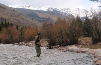
Fishing the Eagle and Upper Colorado Rivers as a part of the Eagle Blue Trail is one of the most popular recreation activities. Whether you are fishing from the banks on a public access point or casting a line from a boat, there are many opportunities to catch a whole lot of fish!
Colorado Fishing Rules and Regulations:
After purchasing your fishing license, check the fishing laws and regulations that apply in your area. Anglers are required to follow both statewide and waterway specific rules so that fish populations are protected now and into the future. Always check for fishing regulation updates prior to each fishing trip.
Colorado Parks and Wildlife Fishing Rules and Regulations
Colorado Parks and Wildlife’s Total Licensing System
Ethical Fishing Best Practices:
Fishing ethics and proper fishing etiquette are responsibilities of all anglers. These ethics and etiquette can be distilled down to a “golden rule” – treat others the way you want to be treated. Be respectful of others and be responsible for the area you are fishing. If you are new to the sport, some of these practices may not be as obvious as others.
Take Me Fishing Ethical Fishing Practices
Remember, as long as you have a valid fishing license, fishing ethics are not in place to restrict you. Fishing ethics are in place to help build a positive angling community.
For more information about fishing in Colorado, check out these resources:
Colorado Parks and Wildlife Fishing Page
Colorado Parks and Wildlife Fishing Brochure
Colorado Parks and Wildlife Boating Statutes and Regulations
BLM Fishing Information
Miller Ranch River Easement and trail | Photo by Matt Stern
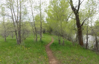
There are many great ways to enjoy the Eagle Blue Trail from the bank. ECO Trails was created in 1996 to finance mass transit improvements in Eagle County. Part of this program is the Eagle Valley Trail which is a paved path running from east to west through Eagle County, connecting to spur trails and backcountry trails along the way. Much of the Eagle Valley Trail runs along the Eagle River, providing appropriate access points at strategic locations.
While enjoying the river from its banks, it’s important to understand ways to minimize your footprint and take care of the spaces you love. Riparian habitats along the river corridor are home to many local plants and animals and are very sensitive to human impacts. You can protect these important ecosystems and yourself by following a few simple guidelines for safety and etiquette in the riparian zone.
- Always use appropriate access points to avoid trampling sensitive riparian plants. Appropriate access points are labeled and selected for safe access to the river.
- Use binoculars or other devices to view wildlife from a safe distance. Never approach wildlife, as wild animals are unpredictable and may become dangerous if they feel threatened. Keep wildlife wild – never feed wildlife. Human food can make wildlife sick and create a dangerous situation when wildlife associates humans with food.
- Follow the Leave No Trace 7 Principles to reduce your impact and be good stewards of the land.
- Plan your trip and be prepared with appropriate clothing, food and water. The sun is more intense at high altitudes, be sure to protect your skin and drink plenty of water to avoid dehydration
ECO Trails Cycling Rules and Etiquette
Colorado Parks and Wildlife: Trails
Colorado Parks and Wildlife: Learn To Camp
Colorado Parks and Wildlife: Ethical Wildlife Viewing Tips
Colorado Adventure Center Bike Path Etiquette & Rules
The origins of rivers are small unnamed networks of wetlands and waterways that come together above and below ground as they flow downstream eventually forming your favorite streams and creeks. The health of these small streams and wetlands is critical to the water quality and quantity of all downstream waterways. These headwaters are vital to mitigating flooding, recycling nutrients, and providing habitat for wildlife. If these important waters are polluted, filled in, or otherwise compromised the entire stream network will be adversely affected.
A new rule proposed by the Office of Surface Mining Reclamation and Enforcement, the Stream Protection Rule (the Rule), should help protect the headwaters of rivers including perennial, intermittent, and maybe ephemeral streams, from many of the adverse impacts of coal mining. You might think that these headwaters are already protected under the new Clean Water Rule; however the Clean Water Rule only addresses the definition of “waters of the United States” in the Clean Water Act, which only applies to surface waters. The Stream Protection Rule will apply to surface and subsurface waters affected by coal mining. The Rule will replace the decades old rule that currently regulates the impacts of coal mining on America’s waters and will be a step towards better protection of headwater streams, native wildlife, and the quality of water both above and below the surface.
To help ensure the nation’s rivers withstand mining activity, the Stream Protection Rule should:
- Define what would be material damage to the hydrologic balance outside the permit area and require that permits include the point at which that damage would occur.
- Provide guidance on how to establish a baseline of environmental health for a mining site that could then be used to help determine the impacts mining has on that site.
- Provide guidance on how to monitor water quality before, during, and after mining activities.
- Require restoration of perennial and intermittent streams that impact the quality of downstream waters (it is possible the final rule may protect ephemeral).
- Promote the use of current technology, science, and methodologies related to hydrology, runoff management, and stream restoration.
- Increase mandates to ensure financing of water quality treatment if mining impacts warrant long-term care.
- Better protect fish and wildlife.
The proposed Rule will be open for public comment for sixty days after it is published in the Federal Register. American Rivers and others concerned with the quality of our nation’s water are requested by the Office of Surface Mining Reclamation and Enforcement (OSMRE) to comment on how to improve the rule OSMRE has been clear that mining activity can be detrimental to ecological health and proposes the Rule as a means to minimize or eliminate mining impacts to streams. The goals of the Rule outlined above, if properly implemented, will be an improvement over the old rule by increasing stream health monitoring and provisions for restoration of impacted streams. American Rivers will analyze the Rule in order to identify those provisions that best protect the nation’s critical headwater and small streams at and downstream of permitted mine sites before impacts occur.
For example, as noted above, one area that is being considered is the inclusion of ephemeral streams in the Rule. Protecting these highly productive waterbodies from mining’s impacts should be an important provision of the Rule. As part of our analysis, we will also look to see in what areas this Rule might fall short and need improvements. One such area is the omission of a clear requirement for a buffer zone around streams. American Rivers would like to see language in the final rule that requires a 100 foot buffer surrounding streams in order to adequately protect them from the disturbances caused by mining. Science supports forested buffers and demonstrates wider buffers are best to ensure clean water and healthy streams and riparian habitat.
Whether swimming, fishing or paddling, being close to the water and under the cooling shelter of the shady riverside trees provides a spot of reprieve from the heat and an abundance of summer fun!
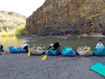
In early July, American Rivers’ Fay Augustyn and I were lucky enough to visit the sublime Verde Valley and explore really unique, off-the-beaten-path destination. Guided by Susan, our resident outreach coordinator, we hooked up for a day outside with local partner Bob Rothrock, President of Verde Valley Land Preservation, to show us first-hand the amazing asset that the Verde River is to the Valley, and discover how it adds so much to the state of Arizona and the greater Colorado River Basin. Not only is the Verde an important natural, cultural, historical, and economic resource to the immediate area, but it also is one of the last perennial streams in Arizona and a mecca for recreation in the northern part of the state.
Bob and Susan led us on a unique (and sweltering!) excursion that ended with a cooling dip in the Verde. After a short hike through a stunning, tight little canyon, we came upon the banks of the river – lined with towering Cottonwoods casting their shady relief over our intrepid little party. We were lucky enough to escape the Arizona sun by taking a dip in one of our local partner’s “top secret” Verde River swimming holes. I’d never been on this stretch of river, and it was a great way to experience it on a day that easily topped 100 degrees. But the temperatures didn’t seem to bother the several bird species we saw as we leisurely soaked with the slow moving current – and with lizards darting about and a pair of dragonflies buzzing above, one could easily get the sense of being surrounded by a bustling community of nature. A true oasis in a scorching, July landscape, this secluded canyon reminded us of the special little niches of life that exist and thrive in these harsh environments, if we simply give them a chance.
Our mini-adventure was such a great reminder about why the Verde and other desert rivers are so important, and what an amazing retreat they provide to not only local residents and tourists but also a wide variety of wildlife. We will be collaborating with local partners and other interested community members in the coming year about how to continue to appreciate and enjoy this truly unique and exceptionally valuable area of Arizona – it would be great if you could join us for the journey!
Photo of the Verde River by Susan Culp
This past week I had a chance to see first-hand the connections between headwaters and drinking water that we think about a lot here at American Rivers.
I was backpacking with my family in the Vogelsang region of Yosemite National Park under clear blue skies with high Sierra meadows dominating the views and landscapes. At elevations over 10,000 feet, it is truly spectacular country where the snows usually come early and leave late. With the recent droughts in California, there were few signs of snow in late June, and we hiked through dry sections that most Junes would be wet and soggy.
Even with the dry conditions, the meadows still had a little water left to release into the small streams we were hiking near. Some of my colleagues here at American Rivers like Dr. Luke Hunt have described healthy meadows as sponges that can hold immense amounts of water to release slowly during the dry months as a way to keep the rivers flowing downstream. In our case, we were hiking at the very top of these watersheds across and beside trickles of water too small to have names. Even though they were nameless, they were beautiful and running completely clear with clean water that until recently was literally as pure as the driven snow.
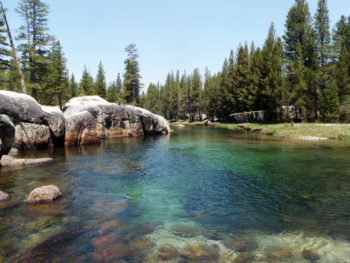
Yosemite National Park Tuolumne River, CA
As we followed those streams down from the high elevations, the sounds of the creeks grew louder as they were joined by other nameless creeks to become large enough to now have names like Rafferty Creek and Ireland Creek. My kids wanted to dunk their heads every chance they got.
We continued to hike down past where the creeks joined the Lyell Fork of the Tuolumne River in a U-shaped valley that was carved a long time ago. There were deep green swimming holes that the trout use year-round. There were undercut banks, riffles, meanders, and some long, straight sections where the water was so clear that you almost couldn’t tell it was there. And drinking this cold water kept us going through the heat of the day.
Two days later, I was down near San Francisco having dinner with some old friends (though they’d claim to not be that old). When the waiter brought our waters, it struck me that I might have hiked along this same water just a few days before. San Francisco gets its water from the same Tuolumne River that is fed by Ireland Creek, Rafferty Creek, the Lyell Fork, and then the main stem Tuolumne that flows through steep canyons before reaching Hetch Hetchy Reservoir – San Francisco’s main water supply.
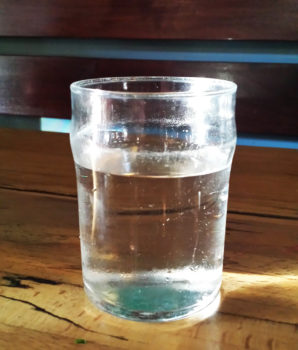
Cup of clear water at our restaurant
So with my friends there at the table, I raised my glass of clear, clean tap water to toast the meadows, creeks, and river that had brought it from those high elevations to a pizza restaurant where normally we wouldn’t think twice about it.
It was a nice way to think back to how these beautiful streams give us so much that we need and to recognize that clean water doesn’t just happen – it takes a natural, protected river system to make it happen.
The endangered Columbia River is the lifeblood of the Pacific Northwest, cranking out energy and irrigation water for the benefit of millions of Pacific Northwest communities, industries, and farms. However, the dams that have provided these long-term benefits have taken their toll on the Columbia native fisheries, including salmon and steelhead. In a good year, the Columbia River used to host salmon runs in excess of 30 million fish. Today, reaching five to ten percent of historic runs is considered “good,” even when much of today’s runs are composed of hatchery fish rather than wild salmon. Several individual salmon stocks remain at only about one percent of historic abundance and are at high risk of extinction.
Fortunately, there is hope that a better balance can be struck for the Columbia River by modernizing the Columbia River Treaty with Canada. Just last week some news came out to bolster that hope: In a letter to Senator Patty Murray, the U.S. Department of State indicated that it would include “ecosystem-based function” along with the traditional Treaty purposes of flood risk mitigation and hydropower in its draft negotiating position.
This is great news, and could offer a boost for domestic and international efforts to restore fish passage past big dams without fish ladders, like Chief Joseph and Grand Coulee dams. An improved Columbia River Treaty could also provide more natural flows to benefit salmon, especially young salmon migrating to the sea in the spring and summer. However, now is not the time to let up!