I was standing along my local river the other day, under a blue sky with a gentle breeze slipping by. Soft sunlight from above reflected off the nearby cliffs and a muted silence surrounded my thoughts – rare for a beautiful Sunday morning in August. Normally there would be kayakers surfing the wave at Smelter, and kids hopping around chasing striders by the water’s edge, and cyclists zipping by on the bike path behind me. But it was silent. Eerie.
By now you have certainly seen the news about the tremendously tragic, toxic release of abandoned mine waste into the Animas River near Silverton, Colorado.
More than 3 million gallons of toxic sludge were blown into Cement Creek, a key headwaters stream to the Animas, turning the river bright orange and sparking a loud outcry of rage, blame, and sorrow.
But unfortunately, this accident has been waiting to happen for decades, as this particular mine was closed in 1923, left abandoned by the mining operators for the public to clean up generations later. This is exactly what the EPA was beginning to do when the release was triggered. Much blame has been laid at the feet of the EPA, and they have expressed their apologies and commitment to address the immediate mess as urgently as possible. But it is really the toxic legacy of abandoned mines, and just within the area surrounding Silverton in San Juan County, there are over 1,100 of these sitting idle, that is the real story.
How much longer will these abandoned mines continue to leach their poisonous legacy into our streams? How much longer will they impact fisheries, agriculture, and the communities that depend on these rivers for their core viability?
In fairness, it’s not like there are floor plans available for the more than 4,000 abandoned mines in Colorado alone. Much work must be done to reduce or eliminate the toxic legacy of mining effluents running into our streams every day, and we hope that this effort will take on an even greater degree of urgency after this tragic event.
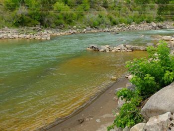
Animas River, CO, after a toxic mining waste spill
It also signals a need for even greater vigilance in protecting our rivers – especially the last remaining pristine rivers across the country, like the Smith River in Montana. Named as one of America’s Most Endangered Rivers® of 2015, the Smith is cherished by Montana residents and river runners and anglers from across the country, as one of the last, best places to experience a true escape from the pressures and pace of a fast-moving world. It also is a sustainable economic engine, generating over $4.5 million per year in tourism and jobs in central Montana.
Half of the rivers we named in this year’s Most Endangered list are threatened by mining: the Colorado River in the Grand Canyon, Montana’s Smith River, Alaska’s Chuitna River, Oregon’s Rogue River, and Minnesota’s St. Louis River. Industrial scale mining can have devastating and permanent impacts and we must mobilize public action to protect clean water and river health.
American Rivers is actively working to protect places where mining is proposed, and we will remain dedicated to the idea that it is unacceptable to put our river economies, river heritage, river recreation, and clean water for people and natural communities at risk.
I don’t want to see another river somewhere else in Colorado, or anywhere else in the country, suffer the same fate as the Animas. Let’s get to work.
The Washington Post featured an interesting article about how gazing upon awe-inspiring vistas makes people more generous, more thoughtful, and a bit more giving with themselves and those around them. Being in the presence of something so grand, and so much bigger than any one individual, changes how people think and act towards one another.
[metaslider id=32790]
In the article, the Grand Canyon was one of the prime examples of this phenomenon, and anyone who has stood atop the canyon’s mighty walls, or craned their neck from the serpentine waters in the bottom of the canyon can attest that this is true. The canyon, and so many other expansive landscapes like it, has the power to change a person, simply by being.
But threats to places like these are constantly swirling, and with the Grand Canyon in particular, these kind of unwise development efforts are very real.
Between an unwise construction project that could plunge up to 10,000 people per day into the depths of the canyon, to a (now on the shelf) groundwater development scheme on the South Rim, to mining for uranium just outside the gates of one of our country’s most iconic National Parks, the Grand Canyon is surrounded by threats that could change, and diminish, the very character that is revered by so many from around the world.
Aside from simply the physical monuments in the canyon, the river inspires an emotional response as well. In 2015 we released a film by Forest Woodward and Gnarly Bay productions, The Important Places, that beautifully captured the relationship between a father and son over the course of a Grand Canyon journey. While these two men, young and old, were the obvious characters of the film, it was the Grand Canyon itself that forged the bond that brought them together.
Check out the film
[su_youtube_advanced url=”https://www.youtube.com/watch?v=ffNPOnbTkmo” width=”1000″ height=”520″ rel=”no” https=”yes”]https://youtu.be/mbpmAJq4XWw[/su_youtube_advanced]
The Grand Canyon continues to need our vigilance, and requires our protection and honor, to remain as one of our nations most revered, irreplaceable national treasures. These places of awe are central to who we are as people, and how we relate to each other in the presence of such beauty, and sublimity. It is a treasure that we should cherish on every level, even those we may not fully understand.
Now It’s Your Turn
So tell us: Have you been inspired by something truly grand, like the Grand Canyon? Let us know in the comments below.
My little boys are growing up. My older one starts kindergarten next month. My little one is charging out of toddlerhood, becoming more independent by the day. Life moves so fast, and the best way I know to slow things down and treasure the moments is to get out on a river.
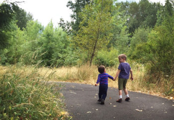
So I took the boys to Oaks Bottom Wildlife Refuge. It’s in the heart of Portland, not far from our house.
A little piece of wildness on the Willamette River. An easy urban escape. It was cloudy, a welcome break from the record heat and drought we’ve had this summer. The alders and cottonwoods smelled so good as we walked the shady trails.
Walking down to the river, we talked, free of distractions. At home I feel as if I’m always trying to do five things at once and conversations are constantly interrupted. But here, it’s just us. No chores or emails, just walking and chatting. Just being, together. My five year old reaches out to hold my hand, and my heart melts. How much longer until he’s too old, too cool, for this?
As we walk, I’m thinking about a recent New York Times article, How Walking in Nature Changes the Brain. The story looks at how spending time in natural spaces reduces anxiety, worry and stress.
For me, rivers are medicine. I know when I need a break, when I need to get out for a float, swim, paddle, or streamside hike. If walking in nature changes our brains, then spending time on rivers must deliver an even bigger bang for the buck, right? I’m thinking of multi-day river trips. I’m thinking of finding peace and connection, of open hearts and strengthened spirits. Healing waters. I’m remembering floating on my back down the Salmon, nights in the Grand Canyon, early morning kayaking on the Potomac…
My boys, racing for the river’s steep bank, bring me back to earth. I snap out of my reverie and take their hands. Together, we carefully approach the eroded edge. A sailboat is anchored here, and kayaks paddle by. We wave, and they wave back.
My five year old asks if he can get a kayak for his birthday.
I think that’s his best birthday present request yet. And I’m game. Any excuse to get us out here more often. For fun, of course. But also to test our own mini science experiment that nature, that rivers, really are fundamental to our health, well-being, and relationships. That they are essential to our happiness, to who we are.
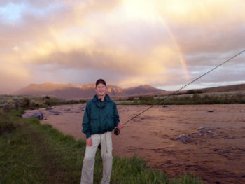
On a recent fishing trip to Montana, I saw another reason why the state’s nickname is the Treasure State.
I was in the southwest corner of the state with my son, brother, and cousin trying to get a few of Montana’s big trout to eat a fly.
We were on one of the state’s more popular trout streams, the Madison, at one of its most popular sections, $3 Bridge, with Rainbow trout being the main fish we were after.
It’s a real success story that this is such a popular stretch of river, since several years ago there was a proposed diversion that would have pulled a significant amount of water from the river for a proposed and unneeded hydroelectric plant. Thankfully, American Rivers and our partner organizations opposed the project and it hasn’t happened, leaving the river in good shape and the trout plentiful.

Finding Rainbows with my son
Though the parking lot was pretty full, we had no problem walking downstream far enough to find some open water.
My son is 15 and had done well earlier in the week in Wyoming, and he was excited by the prospect of a bigger fish here.
Thankfully, the river cooperated, giving up several, including a beautiful 17” Rainbow that was his biggest fish to date.
Not long after, the weather changed as it seems to do a lot in Big Sky Country. After a brief, heavy rainstorm, we were welcomed back onto the river by a full rainbow overhead, with colors that inspired the name of the trout we were after. This bright rainbow seemed to be saying that there were more fish to be had, so we continued fishing and catching till dark.
Luck of the Irish
We have enough Irish in our family that when we think of Rainbows, we naturally think of pots of gold. So at the end of the day, having seen both kinds of rainbows, we were greeted by a golden sunset over the river that one of the locals said was spectacular even by Montana standards.
Appreciating what the day had given us, we thanked the Madison, the state of Montana, and the conservation efforts of American Rivers and local partners for sharing Montana’s treasure once again.
Today’s blog was originally published by Charlton Bonham and Steve Rothert as an op-ed on The Sacramento Bee.
For the first time in 100 years, spring-run Chinook salmon could return to their historical spawning habitat in the Sierra Nevada’s North Yuba River under a framework agreement recently announced by the California Department of Fish and Wildlife, National Marine Fisheries Service, Yuba County Water Agency, American Rivers, Trout Unlimited and the California Sportfishing Protection Alliance.
If the Yuba Salmon Partnership Initiative agreement is concluded, it would create the first “collect-and-transport” program for salmon in California, like those used at numerous dams in Oregon and Washington. Salmon need access to their habitat above dams in the Sierra Nevada now, not later.
After years of study, we have learned that the choice in the Yuba River is not whether to remove the Corps of Engineers’ Englebright Dam, as suggested by Yvon Chouinard and Matt Stoecker (“The wrong way to save salmon on the Yuba,” Viewpoints, July 23).
Rather, it is a choice between re-connecting salmon to 30 miles of prime habitat soon, or doing nothing for decades while attempts are made to address the environmental, financial and public safety challenges of removing the dam.
At 260 feet high, Englebright is too tall for fish ladders.
It holds 28 million cubic yards of debris, some of it contaminated with arsenic, mercury and other toxic substances. That material would have to be removed prior to breaching the dam, or it would pose a potentially serious risk to downstream communities.
Removing the dam could cost as much as $3 billion, but would not give salmon access to the best habitat in the North Yuba River.
We agree that transporting fish around dams in trucks is not ideal. Fish agencies will need a strategy for bringing salmon back in each unique watershed. Sometimes dam removal will be the best choice, other times not.
We must make progress wherever and however we reasonably can to recover California’s salmon and steelhead runs. We choose to act now. We invite advocates of removing Englebright Dam to work with us to ensure our effort is successful, until other strategies become viable.
Charlton Bonham is director of the California Department of Fish and Wildlife. Steve Rothert is California Regional Director of American Rivers.
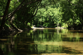
This past week, our family took our yearly trip to visit the Feather River region of Northern California. Even in what are considered wet years, this is a dry and arid place. The tall grasses are crisp and easy to break as you walk through the meadows, and the air feels like it is drawing moisture right from your skin. It’s a nice break from the humidity of North Carolina that we always look forward to. But this year, we have been hearing from the news and our friends how tough the four-year drought has been on California and its rivers, and we were concerned what we might find.
As a microcosm of our concern, there’s one little fish that I had been worried about. Several years ago while exploring the area, I found a small Rainbow trout that lived in a very small pool within a very small stream (“stream” is too big of a word for this trickle of water) that drains a meadow and finds its way to the Middle Fork of the Feather River. The pool is only about 18 inches deep and no more than three feet wide. It is well protected by overhanging bushes and grass pods, and it looked like a place that a little trout might live. As a devoted fisherman, I wanted to see what might be there, so I crouched down, safely back from the pool. After quietly waiting for several minutes, I saw a small trout, only about 5 inches long, swimming on the edges of the shadows. It seemed perfectly happy and seemed to have all of its needs being met. The water runs clear through this little pool, and there must be enough bugs there to keep it going. It was a great little scene with nature’s cycle condensed down in this little pool on the edge of a California meadow. (Click here to learn more about our work to restore Sierra meadows.)
Each year since finding it, I have gone back to see how the little fish is doing. I sneak up on the pool, being careful to not spook the fish with my shadow or to make any noise that might cause it to swim for cover. When I find the fish there, I feel that all must be right with the world for this little trout to have survived another year. It has always been a little bigger than the year before and last year was right around 7 inches long – tiny by trout standards, but plenty big for this stream.
Being worried about what might have happened during these last few months, a few days ago I crept up to the pool and was thrilled to see that there was still some water there. I had envisioned that it would be completely dry and that the little trout would have lost its fight against the drought. But there the pool was, with its water level lower than normal by almost a foot, but still there. It wasn’t a lot of water, but perhaps enough for the trout to still be there, too. And as I crouched down, peering into the clear water, I saw what I had been hoping to see. The little trout was there on the edge of the shadows and seemed to be doing fine. Looking a little closer, I noticed another trout farther back in the pool and a few one-inch-long progeny that were holding their own, as well.
During Bill Clinton’s first campaign for the White House, he would wrap up his speeches by saying, “I still believe in a place called Hope.” With that in mind, I decided to name this little fish Hope. I was so pleased to see that she had made it thus far through one of the toughest droughts in memory, and though the water was way down, she and her family were holding on.
As I stepped back from this little stream with a smile on my face, I thought to myself that I still believe in a fish called Hope.
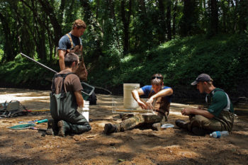
Often at sites of complicated dam removal projects, we conduct monitoring to assess the impact that the project has had on the surrounding environment and examine overall stream health. On the Patapsco River in Maryland, we have removed two dams (Union and Simkins dams) and are preparing to remove a third (Bloede Dam) in Patapsco Valley State Park. As a result, we have partnered with various agencies and contractors to conduct monitoring of both physical characteristics, such as water flow rate and sediment movement, and biological characteristics, such as the presence of fish and macroinvertebrates at different sites along the river.
Recently, I had the opportunity to go out for a day in the field to check out one of the studies being conducted by the Maryland Biological Stream Survey on American eel presence in the Patapsco River both downstream and upstream of Bloede Dam. Not only do I always welcome a day out on the river, but I got to reconnect with my eel friends! I studied American eel (they’re awesome and they are not snakes, so don’t hate on them) in graduate school for my thesis research project. The life history of this species is just fascinating! But I digress…
Enjoying the scenery on the Patapsco River downstream of Bloede Dam | Jessie Thomas-Blate
I donned some waders, threw on my camera backpack, put my biologist hat on, and climbed through the brush to our first sampling site. My research companions explained that they would be using a backpack electroshock device to briefly stun the eels and other fish. They then scooped the eels up into a net and put them in a water-filled bucket. Other species encountered along the way were noted on a data sheet.
After 10 minutes of electrofishing, it was time to measure and weigh the eels. William Harbold, who works for the Maryland Biological Stream Survey, has devised this fantastic measuring contraption for their eel research. If you have never tried to hold an eel, they are very slippery little critters. This measuring device helps keep their wiggling bodies contained a bit while you get a quick measurement of their length. Very cool.
A special device is used to measure American eel | Jessie Thomas-Blate
Once we had them all weighed and measured, the now very awake eels were released back into the river. There are ten sampling sites for American eel in the Patapsco as part of this monitoring effort. We had to keep moving, so we packed up our gear and traipsed upstream to the next site. Due to a complication involving my short legs, I ended up separated from the group and in a heavy thicket of vines. Given my historically poor reaction to poison ivy, I decided to head back out to the road and wait for the team.
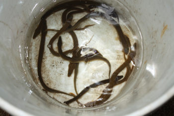
A bucket of eels | Jessie Thomas-Blate
At the subsequent sites, I donned a net and attempted to catch any stray eels. I helped record the eel length and weight data at one of the sites. Then, it was time for some eel wrangling! You might think that the eels would have been more subdued, having just been shocked, but no. Those slippery little fish tried very hard to jump out of my measuring device. At least I wasn’t afraid to scramble after them to get the numbers recorded.
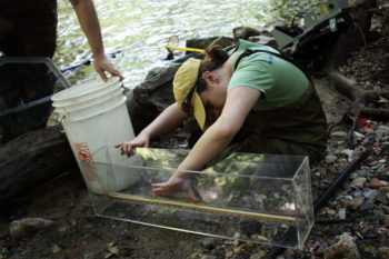
Measuring American Eeel | Jessie Thomas Blate
As we worked on our last site of the day, I felt so grateful to be out on the river. On American Rivers’ Restoration Team, we are fighting every day (mostly from our desk chairs) to open up rivers for fish, wildlife, and people. When I have time to reconnect with nature, I always appreciate the work that I do. I strive to preserve that sense of calm that rivers provide, and the knowledge that we’re doing right by Mother Nature, one river at a time.
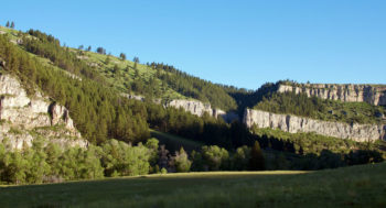
Today’s guest blog is a part of the America’s Most Endangered Rivers® series highlighting the Smith River in Montana. Our guest blogger is Dave Simon, who was born and raised in Montana, currently lives in Billings, and works from home with a view of the Yellowstone River. He works for Bozeman-based Wisetail, a cloud-based next-generation learning and communication system. Dave enjoys the outdoors, particularly hiking with his yellow Labrador retriever, Kenai, as well as landscape and wildlife photography.
Join us as we celebrate the Smith River in Montana throughout August, and be sure to take action!
This year marked my first Father’s Day since my dad passed away last October, and I spent the day reflecting on the gifts he shared with me over the years. The most important being my love of the outdoors and my respect for Mother Nature. My dad taught me that protecting our rivers and streams is a gift that we give to the next generation, and also is a responsibility we pass on, as it was passed to us.
In one conversation late in his life, I was surprised when my dad told me that he wanted his ashes left by Montana’s Smith River, as I had always assumed that he would want them to be with his parents on our family’s getaway near Red Lodge, Montana.

Bruce | Nick Salter
The Smith River is unique in that it is the state’s only permitted river. This year, more than 8,000 people applied to float it, but only 1,175 were lucky enough to get an opportunity to experience this amazing stretch of classic, Montana water.
While the Montana Department of Fish, Wildlife and Parks maintains the boat camps along the route and enforces the permit system, 80 percent of the land between the put-in at Camp Baker and the take out at Eden Bridge is privately owned, and those who float this outdoor treasure take great care to respect the land owners’ property. The Smith is more than simply a natural resource: it also generates at least $10 million in the local economy every year through floating and fishing. Unfortunately, despite the strong stewardship ethic that exists here, the Smith was listed as the #4 Most Endangered River in America in 2015 due to the threat to the fishery from a proposed copper mine along Sheep Creek, a major headwaters tributary to the Smith.
![Heaven on Earth [Smith River] | Dave Simon](https://www.americanrivers.org/wp-content/uploads/2015/08/080315-heaven-on-earth-cred-Dave-Simon-350x214.jpg)
Heaven on Earth [Smith River] | Dave Simon
The Smith was special to my dad. Every spring he would look forward to four days floating through the towering limestone walls and plying some of the world’s best trout fishing. He would describe the beauty of the canyon, the abundance of wildlife, and the ancient pictographs on the walls. He had done this stretch since the 1980s, and his stories about the trips were abundant – he and his friends often floated in early May, experiencing anything from sunshine and warmth to snow and bitter-cold winds and everything in between. He used to remind me that you could experience each of the four seasons over the course of a single trip.
Camp Baker Fire | Dave Simon
Unfortunately, I was never able to have this experience with my dad while he was alive, but this spring he had left me one final gift – I was able to take his place on the annual Smith trip with his same group of friends. During that expedition, I realized that the trip was special to him not just because of the beauty, the wildlife, or the fishing, but because of the bonds of friendship he made sitting around a campfire. We stayed at places with names like Heaven on Earth and Paradise Bend. These names are apt. During that float, with no connection to the outside world, it truly did feel like paradise. I fell in love with the Smith and I understood why dad would want to be there forever.
Paradise bend, morning | Dave Simon
By asking me to take him down the Smith one last time, I experienced the miles of beauty and made friendships I hope to keep year after year. He passed this tradition on to me, one that I will cherish and protect. The river will always be a way for me to connect with my dad, so each of my days on the Smith will be like Father’s Day.
This post was originally discussing Senate bill S 1236. Currently the House Committee on Energy & Commerce voted to add an amendment [HR 8] that accomplishes the same goals with the same problems.
The hydropower industry is attempting a stunning power grab that would make it difficult– if not impossible– to ensure fish passage and other modern improvements to dams, and would eliminate the authority of states and tribes to negotiate for changes to dam licenses that benefit their communities and local waterways. These changes would upset nearly a century’s worth of balance between the competing users of our nation’s waterways.
Make no mistake: if the hydropower industry is successful, Congress will enact new legislation that would upend the balance that currently exists between dam owners and state and community stakeholders. Instead, hydropower dam owners get primacy over our nation’s rivers. In addition, the legislation being considered by the House Energy and Commerce Committee and Senate Energy and Natural Resources Committee would give tremendous new powers to the Federal Energy Regulatory Commission (FERC), a federal energy-permitting agency. In effect, Congress would take power away from state and local agencies that are directly accountable to the public, and give it to an agency that isn’t.
States and tribes should take note. The legislation also creates loopholes that allow hydropower dam operators to avoid having to comply with the Clean Water Act and Endangered Species Act, leaving downstream communities to bear the costs of resulting environmental damage, including pollution cleanup costs.
Our rivers and river communities will be hurt by this legislation, which would strip states of their power to hold dam owners accountable for pollution and damage to local rivers and economies.
Existing law allows states, natural resource agencies, and tribes to advocate for the needs of local communities and waterways during the dam relicensing process. This proposed legislation weakens or eliminates those authorities, which is why states from Maryland to California oppose it. The legislation is also opposed by the Association of State Fish and Wildlife Agencies, which represents the interests of all 50 states.
Existing law requires FERC staff to follow strict rules when communicating with dam owners. This legislation would allow dam owners to have backroom, off-the-record conversations with FERC officials with minimal disclosure and public notice only after the conversation has taken place.
Existing law allows states and federal natural resource agencies to put license conditions on dams that protect local communities and wildlife. This legislation would allow dam owners to petition FERC to reopen licenses they’ve previously agreed to in order to retroactively alter or cancel conditions requested by states to protect local communities. It places FERC’s judgment about how to protect commercial fishing stocks ahead of that of the National Marine Fisheries Service, and it puts FERC’s judgment about how to protect national parks ahead of that of the National Park Service. Local voices and the needs of local communities have been at the center of water resource decisions since Americans first started negotiating water rights centuries ago. This legislation upends nearly four centuries of water law and precedent by placing FERC’s authority above local communities and states when it comes to protecting water quality.
Existing law is effective in promoting transparency and ensuring balance between stakeholders. In fact, the hydropower industry hasn’t demonstrated or provided any evidence that changes to the law will do anything but consolidate power over the nation’s rivers and streams into their hands, giving them priority over anglers, farmers, boaters, and the families and businesses that depend on healthy rivers and clean water.
Healthy rivers are essential to the health and well-being of our communities. Hydropower dams have major impacts on river health, clean water, and wildlife. For more than 90 years, we’ve been able to achieve balance between healthy rivers and hydropower production because local stakeholders, including states and tribes, have had seats at the decision-making table. The public’s right to enjoy their rivers for recreation, drinking water, agriculture, and their natural beauty is absolutely compatible with responsible electricity production, but balance cannot be achieved unless states, tribes, natural resource agencies, and local communities keep their seats at the table. Congress should act on the bipartisan concerns of states across the nation, and join with the more than 100 conservation and recreation groups in opposing this reckless legislation.
Participants at this week’s HydroVision industry conference in Portland will talk about how hydropower is clean energy, while at the same time members of the National Hydropower Association are pushing federal legislation that would let dam owners avoid complying with critical safeguards for clean water and endangered wildlife.
The so-called “Unlock Hydro” legislation, proposed by Rep. Fred Upton, R-Michigan, Rep. Cathy McMorris Rodgers, R-Washington, and Sen. Lisa Murkowski, R-Alaska, wwould roll back protections for fish, wildlife and endangered species, strip states and tribes of their authority to hold hydropower dam owners accountable for water quality violations and make it difficult – if not impossible – to secure fish passage and other dam improvements.
Under existing law, communities can strike a balance between hydropower and healthy rivers. For example, in 2004 Portland General Electric entered into an agreement with the Warm Springs Tribe, anglers and conservation groups to provide significant fish passage improvements on its Deschutes River dams. Today, these dams are still major power producers and, for the first time in 40 years, salmon and steelhead are returning to the Metolius, Crooked, and middle Deschutes rivers. This is just the beginning of the agreement’s implementation and more work needs to be done, but all partners are dedicated to ensuring this river restoration enjoys success for decades to come. The hydropower industry’s legislation could roll back this broad-based agreement and stop future successes like it.
The state of Oregon opposes the legislation because it would take away Oregon’s authority to protect water quality in the state’s rivers. The U.S. Department of the Interior opposes the legislation because it would undermine federal land management agencies’ ability to manage public lands for recreation and the protection of fish and wildlife. It would make it nearly impossible to secure fish passage for the region’s iconic salmon or to protect endangered species. The bill would also strip local communities of their say in how dams on their rivers are managed, transferring that authority to the Federal Energy Regulatory Commission, an energy-permitting agency based in Washington, DC.
Poorly managed dams can dry up rivers, pollute drinking water, kill fish, harm wildlife and eliminate opportunities for fishing, boating and other outdoor recreation. Do we really want dams operated without the protections of modern environmental laws or the input of local communities?
I know from my years as a student in Eugene and practicing law in Portland that Oregonians pride themselves on their strong conservation ethic and connection to the outdoors. American Rivers is proud to share these values.
The hydropower industry’s attempt to pass a bill to exempt dam owners from laws that protect fish, wildlife, water quality and recreation presents a very real threat to our rivers, local economies and quality of life. We urge Oregon’s congressional delegation to join with more than 100 conservation and recreation organizations in opposing this legislation.
Today’s guest blog is a part of the America’s Most Endangered Rivers® series highlighting the Columbia River in Washington State. Our guest blogger is Bob Rees, Executive Director of The Association of Northwest Steelheaders, which has chapters in Oregon and Washington. He is also a fishing guide on the Columbia River.
Join us as we celebrate the Columbia River throughout July, and be sure to take action!
As a salmon fisherman and fishing guide, I know my opinion is often biased. But I can’t believe that salmon, and the future welfare of their species, isn’t a top priority when it comes to natural resource management on the Columbia River and elsewhere – or in this case, un-natural resource management.
If there’s one thing I’ve learned from my short tenure on planet earth, it’s that once humans get a hold of a natural resource, and try to manage it, it gets really messed up. Engineers and ecologists that have the foresight to “manage” our natural resources so that they mimic natural processes actually have a chance to do things right, but the best method is to leave mother nature alone, and let her do her thing.
Right now, thanks to hot weather, low flows, and degraded river habitat, salmon are literally being poached to death on the Columbia River and many of its tributaries. The sportfishing public is sidelined again, doing what we can to ensure we minimize the harm to the species.
When will other industries step up to the plate? When will policymakers choose to do what’s right for salmon? How long does everyone think these species will survive with us “managing” the resource?
For what little we have left to manage, we can’t screw this up too. We need a fair Columbia River Treaty that takes a holistic look not just at hydropower and flood control, but at the needs of all of the Columbia River communities— from macro-invertebrates to apex predators. It’s time everything got a fair shake for a future in our world.
Today we have a guest blog from one of our partner groups — James River Association. Bill Street is CEO for James River Association, and Sterling Nichols is James River Association’s Board Chair who was born and raised in Hopewell, Virginia. The James River Association provides a voice for the river and takes action to promote conservation and responsible stewardship of the natural resources of the James.
This month marks the 40th anniversary of a turning point in the health of the James River. On July 24, 1975, Life Sciences Products in Hopewell, Virginia, was closed by the Commonwealth of Virginia due to the health impacts of its product, Kepone, a toxic insecticide related to DDT.
What made the pesticide so effective also caused harm to the workers and the river. In 1975, Kepone made national headlines as workers fell ill from exposure to the neurotoxin and production was halted by the state. A few months later, the state also shut down the James River to fishing for the same reason – the river ecology was also impacted.
Because Kepone slowly breaks down in the environment, the commercial fishing ban lasted for 13 years, devastating the river’s fishing industry and contributing to the James River being identified as one of the most polluted rivers in America at the time. Today, Kepone still rests in the sediment bed of the James, slowly being covered up year after year and reducing the risk to aquatic life, but it was still found in fish tissue until testing stopped in 2009.
In the year following the Kepone shutdown, the James River Association was formed to be a voice for the river and the people who care about it. Over the history of the organization, we have seen tremendous improvements to the river’s health. As a result, the James is now consistently graded as one of the healthier major tributaries to the Chesapeake Bay, and the river is a major recreation and tourist draw for the communities along it. With a healthier river, Richmond was named the Best River Town by Outside Magazine, and its award-winning James River Park System is the largest tourist attraction in town.
In Hopewell, Virginia, the city is now working with neighboring localities and partners to build riverfront trails, access points and amenities so that people can enjoy the very waters that were closed 40 years ago. Because the river today enhances our quality of life and local tourism, in addition to supplying our drinking water and supporting commercial interests, it means that we have even more at stake in protecting it.
Unfortunately, recent events remind us that toxic spills can still happen on our rivers if we are not vigilant. The Dan River coal ash spill, the Elk River chemical spill, and the James River oil train spill in Lynchburg, Virginia, made headlines across the country. Furthermore, in the past year we have also seen spills in Hopewell, Virginia, that caused fish kills and shut down the city’s drinking water— forcing businesses and schools to close. These events clearly demonstrate that while we have made much progress, our river is still at risk.
Today, there are more than 1,100 chemical storage sites in the James River basin that hold over 80 percent of Virginia’s registered toxic chemicals. Billions of gallons of coal ash sit on the banks of the river in unlined storage ponds. Millions of gallons of highly volatile crude oil travel the railroads along the banks of the river every week.
We are heartened by the recent steps taken to address these concerns, and now Virginia’s Governor McAuliffe and his administration have the opportunity to secure a healthier future for the James River.
Crude Oil Transport by Rail – On the anniversary of the Lynchburg oil spill, three major advances were announced: 1) Governor McAuliffe presented the recommendations of his Rail Safety and Security Task Force, which included increased rail inspections; 2) Senators Warner and Kaine introduced legislation to accelerate the use of safer rail cars; and 3) U.S. Department of Transportation presented their final rule to strengthen safe transportation of flammable liquids by rail. Virginia’s Governor must now ensure that his task force recommendations are fully implemented.
Coal Ash Storage – The U.S. Environmental Protection Agency has issued their first ever coal ash storage requirements, while utilities in South Carolina, North Carolina and Tennessee committed to storing coal ash in fully-lined and monitored facilities. Governor McAuliffe has the opportunity to ensure that Virginia’s rivers have the same protection as rivers in our neighboring states to the south.
Toxic Chemical Storage – This year, the Virginia General Assembly called for a study ensuring that chemical storage in the Commonwealth is conducted in a manner that protects human health and the environment. However, a James River watershed risk assessment, completed by Environmental Stewardship Concepts, found that there are substantial gaps in the information needed to accurately understand the risks facing our waters. Governor McAuliffe can make sure that we have the necessary data and adequate safeguards for the many chemicals stored along the river and discharged into it.
On this 40th anniversary of the bold action taken to address one of the worst toxic contamination events in Virginia, we urge Governor McAuliffe to continue Virginia’s leadership and commitment to the health of its waters and its citizens.
Please join James River Association’s efforts to protect our river at risk.
American Rivers applauds the great work of the James River Association, and looks forward to working together to improve the health of the river for future generations!

