Originally published on Nooga.com.
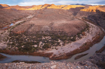
The Cherohala Skyway is a scenic drive that winds 40-plus miles through the Cherokee National Forest and Nantahala National Forest from Tellico Plains, Tennessee, to Robbinsville, North Carolina. This popular drive offers expansive views of mountain ranges piled on top of mountain ranges that bathe in the sun’s golden rays and burst with fall color.
Imagine standing at scenic overlooks like Turkey Creek or Brushy Ridge and the landscape turning digital. Pins would pop up everywhere to mark what lies below the canopy, the little nooks and crannies of wonder and diversity that make this Appalachian landscape unique: waterfalls, swimming holes, trails, camping sites, waterways, and habitat lush with plants and animals found only in this environment.
Surely one pin would designate Citico Creek, a pristine waterway that originates high in the mountains of the Citico Wilderness and eventually empties into Tellico Lake. Located deep within a gorge, the creek is accessed from FS Road 345, which leads to Indian Boundary Lake and Campground, about 15 miles from Tellico Plains.
Citico Creek is designated an exceptional Tennessee stream by the Tennessee Department of Environment and Conservation because of the rich diversity of fish that live within its waters. Fifty-two native fish live in Citico Creek, including the federally endangered Citico darter (a small fish) and Smoky madtom, and federally threatened yellowfin madtom (madtoms are small catfish).
Follow the curvy mountain road that leads to Citico Creek and you will arrive at Doublecamp Campground, a backcountry camping area along its riverbanks. There, 50 years ago, a low dam was constructed in a misguided effort to prevent warm water fish (including green sunfish, bream and creek chubs) in Indian Boundary Lake from migrating into the trout waters of Citico Creek. Today, biologists understand that this was an error—warm water fish cannot survive in the cold water of Citico Creek and therefore pose no threat.
Water tumbles over the manmade structure, and each fall, some fish drama takes place there: Brown trout can be seen leaping out of the water, throwing their bodies against the obstruction in an effort to travel upstream to spawn. No doubt this has been going on since the dam was built nearly 50 years ago.
This week, a track hoe and hydraulic hoe ram changed everything in this little nook and cranny of forest. Thanks to a partnership between American Rivers, Region 8 of the United States Department of Agriculture Forest Service, the U.S. Fish and Wildlife Service, and the Cherokee National Forest, the dam was removed.
“[Citico Creek dam] is the first dam removal to take place as part of a new partnership between American Rivers and the southern region of the U.S. Forest Service,” said Gerrit Jöbsis, senior director of conservation programs with American Rivers, a national river conservation organization.
“Most of our work focuses on dams that are not being used and are causing harm, risking public health and impacting aquatic species,” Jöbsis said.
For half a century, Citico Creek dam prevented the natural movement of fish in the waterway, segregating species into upstream and downstream populations, and decreasing genetic diversity and resiliency. It also interrupted the natural transport of sediment and nutrients required in healthy streams.
“The dam removal along Citico Creek will benefit 13 species specifically,” said Allison Reddington, USDA Forest Service hydrologist with the Cherokee National Forest.
The Citico Creek dam removal began Tuesday. Agency staff watched as a hydraulic hoe ram chipped away at concrete and rebar. Finally, after a half-century, Citico Creek is a river restored.
Today’s guest blog is by Rachel Garwin, policy director for Northeastern Minnesotans for Wilderness.
Canoe flotilla launches Sustainable Ely, an education and action center located in downtown Ely, Minnesota, with help from the American Rivers Endangered Rivers designation
When I dipped my paddle into the South Kawishiwi River on a drizzly day in June 2013, I didn’t know that I was helping launch a movement. American Rivers had listed the South Kawishiwi River and the connected Boundary Waters Canoe Area Wilderness on the list of America’s Most Endangered Rivers® earlier that year, and we unfurled the Most Endangered River banner in front of a flotilla of canoes in order to launch a public action and education center located in Ely, Minnesota, one of the Wilderness’s gateway towns. Nearly 60 people braved the rain and cold to paddle a couple of miles down the river as a testament to value of the river and the wilderness that is both its source and sink.
The Boundary Waters is still threatened by proposed sulfide-ore copper mines, just like it was in 2013 when American Rivers first raised national awareness of the issue, but we’ve come a long way in defending it. The Campaign to Save the Boundary Waters grew out of the same local efforts behind Sustainable Ely, the action center that was launched on June 1, 2013. Since then, the Campaign has continued connecting with Minnesotans and people across the country to educate them about the risks posed by sulfide-ore copper mining and the extreme vulnerability of the Boundary Waters.
Minnesota has never before allowed this type of mining, which is listed on the Environmental Protection Agency’s Toxic Release Inventory as the nation’s most toxic industry. Contamination from the proposed mine sites could indefinitely harm fish and their prey, and the surface infrastructure would unacceptably impact the wilderness character of the nearby Boundary Waters.
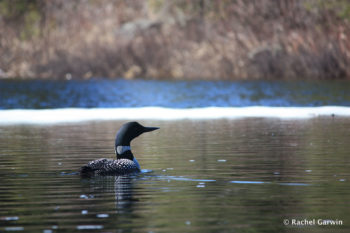
A loon swims among the spring ice on the South Kawishiwi River. Loons and other fish-eating birds would be exposed to much greater levels of heavy metals, including mercury, from sulfide-ore copper mining pollution
The Campaign’s efforts to mobilize a national movement to protect the Boundary Waters have included three “adventure advocacy” expeditions planned and executed by outfitters and guides whose lives and livelihoods depend on the pristine and unspoiled qualities of the Boundary Waters.
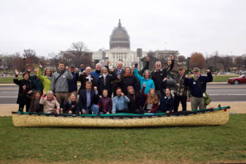
From August to December 2014, Dave and Amy Freeman paddled and sailed more than 2,000 miles from Ely, MN, to Washington, DC, to call attention to the threats posed to the Boundary Waters from sulfide-ore copper mining and collected petition signatures on their canoe. They were greeted in DC by more than 40 Minnesotans who then met with members of Congress, their staffs, and land management agency officials to explain why the clean water and healthy forests of the Boundary Waters are too important to risk to sulfide-ore copper mining.
Then from April to May 2015, three instructors at the Voyageur Outward Bound School pedaled 850 miles from Winona, MN, to Ely, MN— visiting college campuses along the way and engaging with Minnesotans across the state about the mining threat. They collected more than 6,000 petition signatures during the journey.
Most recently, Dave and Amy Freeman launched a year-long expedition into the Boundary Waters to bear witness to the place that would be so impacted by sulfide-ore copper mining, and in Amy’s words, to “speak loudly for a quiet place.”
Tens of thousands of people have taken action as a result of these expeditions and the Campaign’s work including: generating media coverage; working in coalition with business, youth, faith, veteran and sportsmen allies; hosting grassroots house parties; speaking at clubs and service organizations; and otherwise connecting with neighbors and friends about the threats faced by the Boundary Waters. In March 2015, the Campaign and its partners (including American Rivers) delivered more than 60,000 petitions to members of Congress and federal agencies asking for permanent protection for the Boundary Waters. The petitions and public outcry convinced Representative Betty McCollum to introduce legislation in the House of Representatives that would permanently protect the Boundary Waters watershed from sulfide-ore copper mining, while maintaining all other types of uses currently allowed by the Superior National Forest. As the ranking Democratic member of the Interior Appropriations Subcommittee, Representative McCollum’s willingness to defend the Boundary Waters proves the importance of these wilderness waters for the whole country.
By building this local and national movement, we are showing federal agencies and Minnesota’s Congressional delegation that the Boundary Waters is a precious national treasure. As such, the agencies must take a good, hard look now at whether sulfide-ore copper mining is an appropriate activity next to the nation’s most popular wilderness area. Under existing federal law, that hard look must include a full environmental review of one company’s application to renew its federal mineral leases, the environmental impacts of which have never been studied. Additionally, it is within the Bureau of Land Management’s and U.S. Forest Service’s missions as land managers to weigh the environmental impact of turning the Superior National Forest near the Boundary Waters into an industrial mining zone before proceeding in a piecemeal fashion.
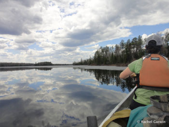
The author paddles the South Kawishiwi River in the Boundary Waters Canoe Area Wilderness before the ice completely melts in May 2013
We are grateful for the support of American Rivers in giving this Campaign its national start, and we continue to educate and mobilize people to take action to protect these beloved waters from the dire threat of sulfide-ore copper mining.
We take heart from the fact that so many people have joined the cause, but we know that more will be needed to protect the Boundary Waters. Until the federal land management agencies and our elected officials take concrete action to permanently protect the Boundary Waters watershed, we cannot and will not rest. Please join us by signing the petition to federal decision-makers asking them to protect this special place!
Rachel Garwin, policy director for Northeastern Minnesotans for Wilderness, which leads the Campaign to Save the Boundary Waters. At the time of the South Kawishiwi River’s inclusion as one of America’s Most Endangered Rivers® of 2013, Rachel worked as a wilderness instructor and lived on the edge of the Boundary Waters Canoe Area Wilderness.
Profit and political influence are back for one more bite at the apple – and in this case that apple is the Gila River in Southwestern New Mexico.
For the fourth time, the New Mexico Interstate Stream Commission and regional water developers (known specifically as the New Mexico CAP Authority) are angling for approval to dam New Mexico’s last free-flowing river, and “provide” water to communities and counties who have publicly stated that they neither want nor need the water from the river.
Included in the 2014 America’s Most Endangered Rivers report, the battle for saving the Gila is still on, even if the opposition from the citizens of New Mexico to damming this river has been consistent, vocal, and strongly one-sided. Choking this historic river for an unnecessary, expensive, and unwanted project – one that may never realize a drop of “new” water – would be nothing short of tragic.
The Gila backed up behind a push-up diversion. That trickle is the river.
I toured the area around the proposed dam site in June of 2014. The area is simply amazing, with stunning blue skies, dappled hillsides, and rocky canyons. With songbirds singing in the distance and trout darting among the shallows, strolling along the banks under towering cottonwoods made me wonder how a desert oasis like this could possibly survive with less than the trickle of natural water that already barely makes it down from the Aldo Leopold Wilderness above.
Would it be worth the death-knell that this project would certainly deliver to this river? This treasured micro-environment and delicate habitat wouldn’t have a chance, especially in the face of a hotter, drying climate in the Southwest. All for a project that many experts say may never deliver a drop of water to the potential “customers.”
Gila River Riparian National Conservation Area
Once again, we need to ask Secretary Jewell to intervene on behalf of wildlife, history, and sound economics, to halt another unwise and unnecessary project.
Once again, we need to think about how we can be better stewards and use the resources we have more wisely and efficiently. Once again, we have to reflect upon ourselves and question whether or not we want to hold ourselves responsible for crushing a place that did not need to go.
If you haven’t spoken out, please do. Let’s stop this project once and for all – if we don’t, the Gila may not get another chance.
Guest post by Tennessee Clean Water Network
We are pleased to announce a victory for the America’s Most Endangered Rivers® listing of the Holston River!
The Tennessee Clean Water Network (TCWN), the U.S. Department of Defense, and BAE Systems Ordnance Systems, Inc. have signed a consent decree that will greatly reduce the level of RDX (a highly toxic, explosive chemical) pollution in the Holston River by 2020. The proposed settlement was filed with the U.S. District Court for the Eastern District of Tennessee on September 28, 2015.
RDX is a toxic explosive compound that was developed during World War II and is only produced at the Army’s Holston Army Ammunition Plant (HSAAP) on the banks of the Holston River in Kingsport, Tennessee. BAE Systems operates the HSAAP under a contract with the Army.
The Environmental Protection Agency’s (EPA) RDX lifetime health advisory limit is 2 µg/L for drinking water. Based on this advisory, the state imposed a strict permit limit for RDX in 2007, but granted the facility five years to comply. The RDX discharge from the HSAAP to the Holston River has routinely exceeded this permit level since the May 2012 compliance deadline.
Prior to the filing of this lawsuit, RDX, a possible human carcinogen, was found in finished drinking water samples taken by the First Utility District of Hawkins County and the samples indicated RDX levels at more than double the EPA’s limit. RDX has been found in the Holston River as far south as Knoxville, more than 100 miles from the HSAAP. The most recent instream samples from the Holston River, taken in April and August 2015, were well below the EPA limit.
As a result of this history of pollution, the Holston River was named as one of America’s Most Endangered Rivers® of 2015 by American Rivers because the drinking water supply for thousands of East Tennesseans is at risk.
If approved by the Court, this consent decree would prescribe a date certain of July 2020 for the facility to comply with the RDX permit. The families and communities along the Holston have a right to clean, safe drinking water. TCWN is proud to have played a role in prompting this action to bring RDX down to safe levels in the river by 2020.
TCWN will continue to monitor the RDX levels in the discharge and in the Holston River to ensure these levels continue their downward trend. The Tennessee Department of Environment and Conservation, the Army and BAE Systems had previously entered a voluntary agreement with 14 different projects to reduce the levels of RDX. This settlement does not disturb that agreement, but adds a judicially-enforceable deadline. This is great news for the people of East Tennessee who depend on the Holston as their source of drinking water and for recreational users of the Holston River, including Cherokee Lake.
The Holston River flows 274 miles from the foothills of the Blue Ridge Mountains to the confluence with the French Broad River and becomes the Tennessee River. The Holston River is home to 47 species of fish including smallmouth bass, brown trout, rainbow trout, redline darter, and bigeye chub. The river has played a key role in our nation’s history – it was the site of a 1791 treaty between the United States and Cherokee Indian Nation, and also saw many battles throughout the Civil War.
Please join us in celebrating this wonderful news!
Tennessee Clean Water Network is a non-profit organization that empowers Tennesseans to exercise their right to clean water and healthy communities by fostering civic engagement, building partnerships and advancing and, when necessary, enforcing water policy for a sustainable future.
The Clean Water Rule which was promulgated by the Environmental Protection Agency and Army Corps of Engineers is not being implemented.
The Clean Water Rule protects our precious streams, rivers, and wetlands across the United States that we rely on for drinking water, recreation, and our economy. Unfortunately, on October 9, 2015 the Sixth Circuit Court of Appeals in Cincinnati, Ohio issued a temporary stay of the Clean Water Rule while litigation there is ongoing.
What Happened in the Sixth Circuit Court of Appeals?
The Sixth Circuit Court of Appeals is tasked with issuing a decision on the Clean Water Rule’s validity. The petitioners are the states of Ohio, Michigan, Tennessee, Oklahoma, Texas, Louisiana, Mississippi, Georgia, West Virginia, Alabama, Florida, Indiana, Kansas, Kentucky, North Carolina, South Carolina, Utah, and Wisconsin.
These eighteen states are seeking to have the Clean Water Rule invalidated by the court. As part of their case they petitioned the court to stay the Clean Water Rule pending the completion of the court’s review of their case. The Environmental Protection Agency and the Department of Defense (which houses the Army Corps of Engineers) opposed the stay as did several conservation groups as well as the pro- Clean Water Rule states of New York, Connecticut, Hawaii, Massachusetts, Oregon, Vermont, Washington, and the District of Columbia. Unfortunately, the Sixth Circuit Court granted the petitioners’ stay.
There are two parts to the decision the Sixth Circuit must make. First, the Court must decide if they have subject matter jurisdiction over the case (meaning if they even have the authority to hear the case before them). Second, the Court must decide on the validity of the Clean Water Rule based on its merits. The decision as to whether the court has the authority to hear the case on the validity of the Clean Water Rule will be decided shortly. If the Court decides they do not have the authority to hear the rule than the stay will be lifted. If the Court decides that they do have the authority to hear the petitioners’ case then the stay will most likely be in place until the validity of the Clean Water Rule is decided, which could be months or more likely years.
What Does a Stay Mean for the Clean Water Rule?
This means that the Clean Water Rule will not be implemented across the United States until the Sixth Circuit determines that the Clean Water Rule is valid or they decide they do not have jurisdiction to hear the petitioners’ case and the stay is lifted. Since the Clean Water Rule is not allowed to be implemented the old status quo of pre-Clean Water Rule guidelines following the Supreme Court’s decision in Rapanos v. United States will apply nation-wide. This means that the confusion as to which waters are and are not covered by the Clean Water Act will once again reign while the Court deliberates. Unfortunately, this puts the drinking water sources for 1 in 3 Americans back at risk.
While American Rivers is disappointed with this new roadblock to the implementation of the Clean Water Rule, we are confident in a positive final court decision resulting in the Clean Water Rule being implemented in all fifty states. The stay is just a ripple along the way to protecting clean water for everyone
Within the area of the Great Divide, the St. Louis River is the primary river of northeast Minnesota that flows into Lake Superior. Adjacent waters flow north into the Rainy River or south into the Mississippi.
As the St. Louis picks up volume due to the emptying of its many tributaries, the river flows through the Tribal Nation of Fond du Lac and forms a fresh water estuary as the river meets the Lake. The tributaries that feed into the St. Louis form a water filtration network that nourishes the forests and wetlands of Superior National Forest.
In the not-so-distant past of the early 1900’s, the Federal Weeks Act of 1911 provided for the addition of land to Superior National Forest for the purpose of protecting the headwaters of navigable streams. After a period of intense logging that cut down a hundred years of white pine in only thirty years’ time, national figures saw the need to manage lands in a way that valued the primary resources of woods and water.
For the remainder of the century, Superior National Forest gradually regenerated, although the white pine forests never returned. The parts of the forest surrounding what is now the Boundary Waters Canoe Area Wilderness came to serve as a buffer zone, protecting the quality and character of the area.
Then, in an unfortunate turn of events, something changed in the latter part of the 1900’s. A new mining process that crushed taconite rock into iron pellets made inroads into Superior National Forest and into the St. Louis River watershed. Now, the taconite industry is leaving behind a legacy of mercury and sulfates, impacting the fish, wild rice, and quality of the waters of the St. Louis River, and ultimately Lake Superior itself.
While state agencies scramble to find ways to clean up the water, the very same agencies are on the brink of permitting a new even more toxic kind of mining— for copper/nickel minerals in sulfide ore, which are highly dispersed throughout the bedrock of the area between Lake Superior, along the North Shore, and across to the Boundary Waters. Due to the low quality of these ores, the volume of waste rock will be astronomical.
A company known as PolyMet is the first in line for permitting, and would be mining 99 percent waste rock at their project site. Meanwhile, there is no known sulfide ore mine that has been able to prevent water contamination from acid mine drainage and toxic heavy metals, which lasts for centuries.
Recent government leaders have relinquished the lessons learned by their predecessors. They are falling for mining company propaganda that claims their mines will not impact the environment in any negative way— a foolhardy statement that flies in the face of both science and on-the-ground reality. No research has even proven the claims that all such metals are needed in order to keep afloat our reliance on current technologies.
So while the city of Duluth is seeking approximately $70 million to clean up a U.S. Steel superfund site along the St. Louis River, our state agencies are promoting another onslaught of pollution within the upper reaches of the river.
The iconic beauty and quality of the St. Louis River watershed is at risk. Our agencies and leaders are ignoring the fact that clean water is a valuable natural resource. We have lost respect for the quality and character of Lake Superior itself; we have forsaken the generations who will follow us. Who will rise up and step forward from within the ranks of bureaucracy in time to save us from ourselves?
The damage that had been undone but tried to be redone won’t be done again. I apologize for the confusion but I was equally confused when a power company proposed to build a dam on a pristine section of the Bear River in Idaho just a few miles downstream of where a dam had been previously removed. Thanks to the smart staff at a federal agency that regulates hydropower in our nation, the dam will likely not be built.
The staff at Federal Energy Regulatory Commission issued a draft Environmental Impact Statement (EIS) last week in which they urge the Commission not to issue a license for a proposed 109-foot-tall hydroelectric dam proposed on a section of the Bear River in southeast Idaho found suitable for Wild and Scenic river protections.
In their findings, the staff determine that even the mitigation measures proposed by the power company “would not adequately offset the adverse effects of constructing and operating a new major hydroelectric project on a currently scenic river reach in an undeveloped canyon with remarkable recreational, geological, and wildlife values and public access.”
The removal of Cove Dam on the Bear River in 2006 happened as part of a hydroelectric settlement with another power company and reconnected 29 miles of the river, restored fish-spawning tributaries and improved fish habitat and water quality. If allowed to be built, among other things, the new dam would’ve caused a substantial reduction in the size of cutthroat fishery, resulted in a loss of 4.5 miles of habitat for Bonneville cutthroat as well as loss of 249 acres of conservation land which was a result of a previous licensing settlement. However, the determination by FERC staff in addition with a denial of water right by the Idaho Department of Water Resources in 2012 has effectively killed the project.
For now, the fish can rejoice.
I was glad to be heading back to Columbia after two days of soggy weather at American Rivers’ Board meeting in Beaufort, South Carolina. I couldn’t stay an extra day to fish the Broad River for redfish with my friend, who also happened to be in the area that weekend for a wedding. I’d be home before dark and escape the worst of what was left of Hurricane Joaquin and the coastal flooding it had caused. Except for a few downpours mixed in with steady rain, the drive back home was uneventful. I was glad to be home, dry and with my family.
[su_youtube url=”https://www.youtube.com/embed/_plT_Ii79QI” width=”1020″ height=”580″]
I lost count of how many times the National Weather Service flash flood alert on my iPhone went off that night. I do know that each time I was awakened it seemed to be raining even harder, but I wasn’t overly concerned. We were almost a mile from Gills Creek and on high ground, not in an area prone to flooding.
With Sunday morning’s daylight I saw water running across our lightly sloped back yard and ponding at the back of our house. I soon learned that it had overtopped our air vents and spilled into the crawl space flooding it with more than a foot of water and partially submerging our furnace. Not long afterward, our power flickered and went out. Our city-supplied water lost pressure, turned a muddy brown, then stopped altogether. No longer could I think that we were safe from what was a historic deluge. Sixteen inches of rain in 18 hours doesn’t pick favorites.
Or maybe it does. Just blocks away neighbors living closer to Gills Creek were experiencing a major flood that topped the eaves of houses supposedly on high ground.
Even with that much rain, how could Gills Creek carry so much water? It was later that afternoon when I heard of the dam breaks. Cary Lake Dam had failed, then Pine Tree Lake Dam, then Semmes Lake Dam. The destruction continued into Monday with the dam at Upper Rockyford Lake giving way and sweeping along with it the Lower Rockyford Lake Dam. A cascade of dam failures, like dominos in a child’s game, had turned a small tributary stream of the Congaree River into a raging torrent that was unfazed by bridges, buildings and roadways. It indiscriminately carried away those who dared to drive through flooded crossings – many to be rescued by first responders, some not.
We don’t know what the future holds for rivers in the Columbia area. In addition to the Gills Creek dams, dams failed in Lexington County. A total of nine dams were lost and many more are teetering. The historic Columbia Canal, which for generations had supplied Columbia’s drinking water, had a gaping, 60-foot hole blown through its banks, jeopardizing the water supply of almost 200,000 Columbia area customers.
We do know that there is a new normal in Columbia and across South Carolina. Climate change predictions of more frequent and more extreme storms are no longer a theoretical debate for academics. We are living it. No politician, regardless of their persuasion, can ignore what has unfolded in Columbia, right?
This is home to me and my family. We live here. Our hearts go out to our friends and neighbors who lost loved ones to the flooding. When the flood waters recede and the time is right to take stock, my American Rivers colleagues and I will join with Columbia and the state of South Carolina to consider what this new normal means for the management of our local rivers and streams. We look forward to helping communities and the state forge a path forward that ensures healthy rivers and community safety.
The upper Flint River of west-central Georgia is a river running dry. For generations, southeasterners could expect lush landscapes fed by plentiful rainfall. The Flint River has fed both the growth of cities and agriculture in the region, but this increasing demand for water has thinned supplies already stressed by recent drought conditions.
In addition to area residents, the upper Flint River supports recreation, fisheries, local economies, and threatened and endangered species that all depend on the reliable flow of healthy water. However, reliable flows are becoming increasingly rare even as millions of gallons of water per day are consistently extracted from the river, and this trend is only expected to increase.
Unfortunately, once the water leaves the river, several types of obstacles prevent it from returning, including tens of thousands of acres of impervious surfaces in the Flint’s headwaters that prevent stormwater from soaking into the ground. Instead, stormwater flooding over farmland, roadways and parking lots washes trash, pesticides, and fertilizers into storm drains and back into the river.
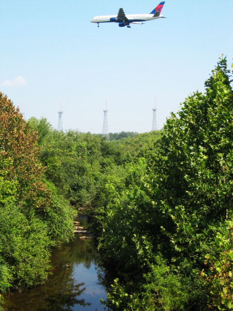
Flint Airport
Drought is also problematic. In 2012, American Rivers’ Ben Emanuel started analyzing water flow rates in the upper Flint River and determined that modern flow rates during drought were anemic compared with historical rates.
In 2012, American Rivers noted a flow rate of less than 100 cubic feet per second (cfs) at a key U.S. Geological Survey stream gauge. For comparison sake, paddlers like to see a minimum of 600 cfs in the Flint, which has occurred roughly 90 percent of the time during July, from 1940 to 1975.
Since 1975, the river has only spent about half of Julys flowing above 600 cfs. In other words, the massive population growth and development in the metro Atlanta area has significantly depleted the river, to the detriment of paddlers and river recreation businesses and enthusiasts. American Rivers described the slow draining of the Flint as “death by a thousand cuts” in Running Dry.
Fortunately, American Rivers is not the only organization to recognize this problem, and partners from across the Apalachicola-Chattahoochee-Flint basin are coming together and working toward a solution. One African Proverb says, “If you want to go fast, go alone. If you want to go far, go together.” So American Rivers, in partnership with the Upper Flint River Working Group, has a strategy to address some of these cuts, we’re working to understand others, and there may be more that remain undiscovered.
Through our long-standing partnership with the Flint Riverkeeper, the issues faced by the upper Flint have been described in great detail for the first time. Now, through this partnership, along with Southern Conservation Trust, The Conservation Fund, and Georgia Interfaith Power and Light, we are implementing strategies that will allow us to make progress toward a healthier river.
We’ve also developed great relationships with stakeholders that might traditionally be considered adversaries, including Clayton County Water Authority, Fayette County Water System, the City of Griffin, Newnan Utilities, Hartsfield-Jackson Atlanta International Airport, and many others. We’re thrilled to be working across the spectrum of river stakeholders to demonstrate that we live, work, and play in an era of stewardship.
Stay tuned for more in this series of blogs, which will discuss the details of what we’re doing, and how you can help!
My heart still skips a beat every time I see a swallow-tailed kite soaring above me. Plentiful osprey make me hold my breath as they dive in to the Waccamaw River for their dinner and nest amidst the tall cypress trees, nothing compares to the tremendous wingspan of the swallow-tailed kite and it’s striking markings and signature forked tail. The Waccamaw National Wildlife Refuge and surrounding area supports the highest density of nesting swallow-tailed kites in South Carolina and is the northernmost documented nest site for the species. These incredible birds are only one of the many reasons the Waccamaw NWR has stolen my heart.
Each and every National Wildlife Refuge is a haven for important species in that area. While NWR aren’t as well-known as National Parks or wilderness areas, they are an amazing place to explore the outdoors, connect with local habitat and experience the amazing species that call the Refuge home. Celebrate National Wildlife Refuge week with us from October 11 – 17th and get out and explore a refuge near to you!
Located in portions of Horry, Georgetown, and Marion counties on the South Carolina Coast, the Waccamaw NWR spans thousands of acres and includes large sections of the Waccamaw and Great Pee Dee (Big Pee Dee to us local folks) rivers along with a small section of the Little Pee Dee River. The wetland diversity sets this refuge apart from others found along the east coast with habitats ranging from historical and actively managed tidal rice fields to black water forested wetlands. The range of habitats in the Waccamaw NWR support more than 400 species of animals- swallow-tailed kite, osprey, wood stork, white ibis, green heron, and many species of waterfowl can be observed on a seasonal basis. I had a birdwatching dream come true this spring as I got to paddle by nesting blue herons high in a massive cypress tree on refuge land. Dozens of pairs had built their massive nests and a fluffy baby or two peeped their head out causing squeals of delight from my all adult outing.
Every time I head out to enjoy the Waccamaw NWR, I know I will experience something new whether it’s new vistas, new birds to spot, a bear spotting, or catching the perfect sunset. I love hiking at Cox Ferry Lake Recreation Area, enjoying the well maintained 3 miles of nature trails. The kiosks provide information and routes to take and there is a shelter with picnic tables, making for the perfect outing for the family or a picnic spot for two.
My favorite way to take in all that the refuge has to offer is pairing up kayaking and hiking. It is the best way to see the Refuge and nothing beats the peace that fills you when you are paddling that gorgeous black water surrounded by the reflections of the cypress and tupelo. I love paddling to Sandy Island, where the Waccamaw and Big Pee Dee Rivers come together mixing their distinctly different waters so it looks like pouring creamer into coffee. The osprey are always calling, pulling you from the city and stress back in to nature.
The Waccamaw NWR is a treasure, protecting precious habitats and helping to provide clean drinking water for the surrounding areas. Locals and visitors alike are able to hike, bike, stroll, birdwatch, fish, paddle, and practice their photography skills on the amazing views and wildlife. I just love the peace that immediately overcomes me when I step in to this amazing resource and gaze over the reflective waters of the Waccamaw. I never miss the chance to take visitors out and thought I could babble endlessly about the history and wildlife, I love watching people fall in love with this refuge all on their own.
What is your favorite way to explore your local Wildlife Refuge?
Think hydropower is green? Think the hydro industry has your best interests in mind?
Think again.
If hydropower is not done right, it can be destructive for rivers and the fish and wildlife that depend on them. It damages natural habitat and prevents fish from reaching spawning grounds. It can dry up entire stretches of river. It’s the only renewable energy source that drives species toward extinction.
For decades, environmental laws like the Clean Water Act and the Endangered Species Act have leveled the playing field between all of us and powerful energy companies like Pacific Gas & Electric, Duke Energy, Exelon, and Southern Company.
But now the hydropower industry is trying to create a giant loophole for dam operators, so they are not required to protect fish, wildlife, or water quality on our rivers.
Now, as industry lobbyists push their so-called “Unlock Hydro” legislation to Members of Congress, they are using all kinds of misleading messages.
Here’s a guide to translating hydro industry talking points into reality:
What they say: The legislation “streamlines” the dam relicensing process
The truth: The legislation guts environmental protections and takes away the ability of states, tribes, local communities, and recreation and conservation interests to have a say in how dams are operated. By “streamlining” this dam relicensing process, the things you value get steamrolled.
What they say: Hydropower is “clean energy”
The truth: As they wave the clean energy banner, hydropower companies are trying to hide a dirty secret – that poorly operated hydropower dams cause major damage to fish and wildlife, clean water, and communities and businesses that depend on healthy rivers. If hydropower is so clean, then why are hydro companies lobbying Congress to get them out of complying with the Clean Water Act?
What they say: The legislation makes the approval process for non-federal hydropower more “efficient and collaborative” by requiring the Federal Energy Regulatory Commission (FERC) to act as the lead agency in coordinating with other federal, state, and local government agencies and Indian tribes.
The truth: There is nothing collaborative about federalizing the states’ role in enforcing state law at dams. There is nothing collaborative about using the power of the federal government to dictate what reviews and studies are necessary for Native American tribes to protect their sacred homelands. It may be efficient to take away states’ authorities to protect their citizens, but that doesn’t make it right. This is a massive expansion of federal authority and a trampling of states’ rights and the rights of Native American tribes.
What they say: The hydropower industry cares about the environment
The truth: Fish, wildlife, clean water, and anyone who enjoys fishing, paddling, and other river recreation will lose if this legislation becomes law. The legislation gives FERC — and thus effectively the power company — the power to limit scope of environmental review. In practice, this will limit the scope of the Clean Water Act and the Endangered Species Act to whatever FERC says it should be. If this bill becomes law, the final say over whether fish passage should be considered at dams would not be determined by fisheries experts, it would be determined by FERC. And, the final say over the protection of sacred Tribal lands would not be decided by the Tribe and the Bureau of Indian Affairs, it would be determined by FERC.
In 1920, the Federal Power Act was designed to provide balance between power generation and all other uses of a river. If this legislation passes, power company profits will go to the head of the line, ahead of every other user. If you care about irrigation, Native American treaty rights, wildlife, recreational fishing, commercial fishing, whitewater boating, water quality, municipal water supply, fire safety, flood control, or any other purpose other than generating power, then you should oppose this legislation.
The hydropower industry is simply going too far with this extreme legislation.
Don’t be fooled by their talking points. Learn more here and here, then take action to protect our rivers.
Over 20 of us huddled under a tent – likely far exceeding its maximum coverage capacity – by the side of the Merrimack River in Haverhill, Massachusetts on a rainy day in August, trying to get to know one another without (literally or figuratively) stepping on one another’s toes. We were on the second day of a two-day river cleanup but were forced to delay the start time due to a thunder storm that had moved in quickly and was since refusing to budge.
The day before had been sunny and warm: perfect for the first day of a river cleanup. The second day, our luck had run dry but our clothes had gotten soaked even before stepping foot on the riverbank. Nevertheless, the employees of Keurig Green Mountain waited patiently for the rain to pass, filling their time catching up and sharing stories from previous years’ cleanups.
Eventually, the sounds of pelting rain on the top of the overstuffed tent became softer and the rumble of thunder in the distance disappeared. Thrilled that the cleanup would not be rained out, we all gathered our life vests, water bottles, and gloves and headed down to the pontoon boat that would be taking us out on the river.
Like the cleanup the day before, we worked with local group Clean River Project to work our way up and down the shores of the Merrimack River. The founder, Rocky Morrison, his crew and two other boats accompanied us, hauling trash and maneuvering a small crane to help with larger items, like a car axle. I watched volunteers help one another climb over fallen trees on the shores and team up to roll 30 water- and sand-logged tires down the beach toward the boats. We all paused to marvel at a 25-pound snapping turtle one of the crew picked up by the tail. When I’d gather the volunteers back by the boats and suggest moving to another cleanup spot, they did not hesitate for a minute. This dedication and enthusiasm led us to pick up 2,200 pounds of trash and 600 pounds of metal in two days!
While I was amazed at the commitment and energy of the volunteers, this attitude is not unique to the Merrimack cleanup. Keurig employees turn out in large numbers, over multiple days, in cities and towns across the country to show their dedication to clean rivers. A couple of weeks before, nearly 200 volunteers in Vermont came out over the span of a week to clean up 2,880 pounds of trash and 2,380 pounds of metal. They hauled 105 tires (and an ATM) from the banks and depths of the Winooski River.
Earlier in the summer, volunteers in Knoxville, TN; Windsor, VA; Sumner, WA; and Castroville, CA participated in similar events. Over the course of these six events, 460 volunteers picked up nearly 10,000 pounds of trash. At some sites, trash was not as much of a problem and volunteers restored riverside lands by planting 75 trees and shrubs and 1,000 grass seedlings. While the activities and experiences (and weather) differed at each site, they all proved the same thing: Keurig’s volunteers are committed to cleaning up their local waterways. National River Cleanup was proud to clean up with the Keurig volunteers across the country for the 11th year and we look forward to returning next year for even more fun!
[slideshow_deploy id=’24903′]
Download the Organizer’s Handbook and register a river cleanup today!