October’s devastating flooding overwhelmed Columbia and other South Carolina communities and shattered our sense of safety and security. While the area received heavy rainfall outside our control, the damage to our communities was compounded by multiple dam failures that we can take steps to prevent in the future. This underscored that the state needs a better strategy for dam management.
Sixteen dams failed in the Columbia area and more than three dozen failed across the state, which sent storm surges through neighborhoods and business districts. The floodwaters claimed roads and bridges, damaged homes, and most tragically, caused the loss of 19 lives.
After the water cleared, three critical facts emerged.
First, South Carolina’s landscape is littered with dams that either don’t meet modern design criteria or are out of compliance with maintenance requirements. Second, the state’s dam safety program is seriously flawed. Most disturbing, the flood levels recorded in most South Carolina rivers and streams did not break records. This disaster was not a once-in-a-lifetime anomaly. It was a warning to expect higher flood levels to become increasingly common.
The State newspaper reported that the Department of Health and Environmental Control has asked for additional funding and new staff positions to double the size of its dam safety program, which is currently resource-starved. To keep downstream families and businesses safe, the state desperately needs more trained staff to verify that dams are well maintained and, when not in compliance with modern safety standards, to rigorously enforce regulations to ensure flawed dams are repaired.
Unfortunately, with approximately 2,400 regulated dams in South Carolina, we can’t expect the Department of Health and Environmental Control to properly inspect all of these structures, most of which are privately owned. Dam owners need to take responsibility to ensure their structures are regularly inspected by certified dam inspectors who then report the results to the state. Further, in the interest of public safety, dam owners should consider removal in cases where they can’t afford necessary repairs. Not only is removing a dam often cheaper and faster than repairing it, removal is always safer than leaving a flawed dam in place.
The Association of State Dam Safety Officials and FEMA recommend a model dam safety program that might benefit South Carolina. Rather than running state employees people across the state, dam safety program staff would concentrate on reviewing certified inspection reports submitted by owners and third-party inspectors and then working with dam owners to ensure deficiencies are addressed promptly and properly. This strategy is less resource-intensive without sacrificing the safety of downstream residents.
Residents should expect that severe bouts of drought and flooding are the new normal for Columbia and South Carolina. Further, the nation’s leading scientists, including some from the University of South Carolina, tell us that catastrophic weather events will become more frequent and more extreme in the coming decades.
We have already suffered needlessly as a result of the extreme rains, devastating flooding and dam failures we should now expect. The safety and security that the citizens of South Carolina so greatly value depends on our taking action now to ensure that all dams meet modern safety criteria and are inspected regularly.
American Rivers is one of the nation’s leading experts on river restoration and dam removal, and we’re always grateful when our successes inspire others to learn from our experiences.
In October, we were delighted to share our expertise with a group of activists, engineers and government officials who want to restore their rivers. American Rivers teamed up with the Southeast Aquatic Resources Partnership (SARP) and researchers from the University of Georgia’s Warnell School of Forestry and Natural Resources to present a first-ever dam removal training workshop on the UGA campus.
American Rivers’ River Restoration staff experts presented alongside speakers from UGA, SARP, the Georgia Department of Natural Resources and U.S. Army Corps of Engineers. The event brought together regulators, students, scientists, conservationists, and government and wildlife conservation agency officials who work at the local, state and federal levels.
The session presented the science and strategy behind dam removal from planning and permitting to construction and habitat restoration and all the steps in between. The workshop concluded with a roundtable discussion about next steps in Georgia. Among those, the group decided to develop a “Georgia Aquatic Connectivity Team,” in which American Rivers plans to participate along with government officials and other interested folks. We expect the team to spark a lot of partnerships and collaborations that will get more projects moving in Georgia.
Partnerships and collaborations are vital for any dam removal success. Recently, American Rivers pioneered an innovative partnership with the southern region of the U.S. Forest Service to remove the Citico Creek Dam in Tennessee’s Cherokee National Forest. The dam was constructed 50 years ago to segregate cold and warm water fish, but researchers discovered the dam was doing more harm than good. We worked with the Forest Service to remove the dam, and are now working to restore the natural stream corridor.
American Rivers will continue working with the Forest Service and other partners to remove unused, unsafe and unsound dams as well as those that risk public health and adversely impact species that rely on rivers.
I have been lucky to visit so many natural treasures across this country, which, when their given names are spoken, conjure up singular images about the place. Grand Canyon, Washington Monument, the Everglades, Zion, Nebraska – when you hear those words spoken, an image flashes across your mind that tells the story of that place in a second. But in the minds of many, the hearing the words “Lake Powell” can spark a diverse collection of thoughts, emotions, and reactions.
Contrasts explode through the mind like a 4-year old in a bouncy castle.
To some, Lake Powell is deemed Lake Foul, and a kinder term for the place does not exist, especially among those who experienced the grandeur and sublimity of Glen Canyon before it was flooded in the 1960’s to supply cheap air conditioning to Phoenix. With others, the name draws images of sun and splashing, of bikini’s and jet-skis and three-season motorized fun. To a few, Lake Powell is a symbol of what is wrong with humanity, and our need to control and confine nature.
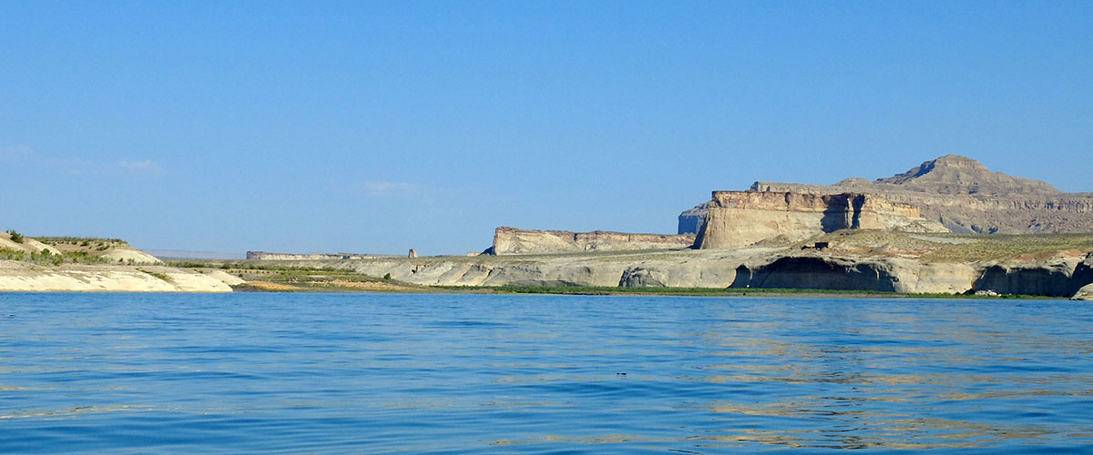
Lake Powell flatwater
Amid those contrasting opinions of the second largest reservoir in the country, Lake Powell has a purpose that touches nearly all of the 36 million people who depend on the Colorado River. Like it or not, as we have become more dependent on water storage in the West, Lake Powell is the one place that helps out states like Colorado, Utah, Wyoming, and New Mexico like no other. Without the existence of Powell, a number of other rivers in those states would be more heavily dammed and diverted – sacrificed for storage and certainty, rather than flowing and in most cases, naturally wild.
It is in this cloud of emotions, and declining lake levels due to lingering drought and overuse of the Colorado River, that a team of five adventurers is setting out this week to experience, contemplate, and capture on film some of the broad horizons and hidden wonders being revealed as water levels drop. In July, I visited the area around Antelope Point at Page, Arizona with a film crew from the Tzu Chi foundation, and we made a short film about water supply and the native people who depend on the Colorado River in Arizona. Again in September, I visited Wahweep Marina and the Glen Canyon Dam in Page with the crew from CNN’s The Wonder List, shooting an hour-long show about the Colorado Basin that will air in February, 2016.
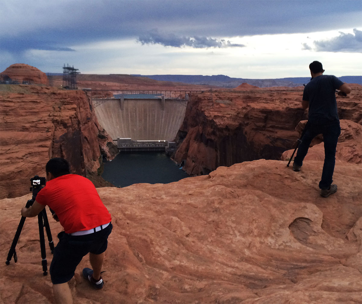
CNN shooting Lake Powell
This time, our team will be traversing the lake from north to south, 83 miles by sea kayak.
We’ll be paddling from Hall’s crossing in Utah to Antelope Point over 10 brisk December days. Kayak Lake Powell is setting us up with boats, gear, and logistical support, although they are likely scratching their heads about why we would choose the dead of winter to launch this trip.
Writers Brendan Leonard and Hilary Oliver, photographer and film maker Forest Woodward, adventurer and pro skier Kalen Thorien, and I will launch our 17-foot crafts and begin the journey south, exploring features like Iceberg Canyon, Cathedral in the Desert, Music Temple, and Dungeon Canyon over 9 days.
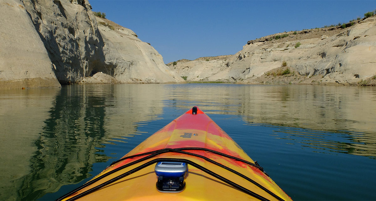
Lake Powell Kayaking
Many features won’t be immediately obvious, and others we may only see their tops – like headstones dotting a 50 year old graveyard – but even knowing that we are bobbing along above some of these lost treasures will invoke the imagination of what is below and was submerged as the waters ascended the canyon walls a half century ago.
Stories and photographs from this trip will grace the pages of Canoe & Kayak magazine in the spring, which is super exciting. We would also like to thank NRS, Smartwool, and Revo Sunglasses for their support of this adventure.
Here’s to warm days and crisp nights!
The Ashley River provides an amazing connection between a historically significant river and diverse natural resource in South Carolina in a relatively undisturbed tidal ecosystem. Last week, we released a new map for the Ashley River Blue Trail, describing access points and activities to enjoy both in and along the river. Are you interested in planning your next trip to the Ashely River? Check out the new Ashley River Blue Trail map to learn where to access the river, find historic features and explore this Lowcountry gem.
Ashley River Blue Trail (North – start of Blue Trail)
Ashley River Blue Trail (South – end of Blue Trail)
Photo Credit: South Carolina DNR, Ashley River
While it is sad to see the river cleanup season come to an end, we now get to look back and think about our successes these past few months. Thousands of cleanups engaged tens of thousands of volunteers and removed millions of pounds of waste from our favorite rivers and streams.
One of the best ways to demonstrate our accomplishments is through photos. While I always eagerly await organizer’s data results, what I really pore over are the pictures that often accompany the trash and volunteer tallies. Before and after shots of recently cleaned riverbanks or pictures of muddy volunteers hauling away bags of trash always remind me of the importance of our river cleanups.
With the end of the cleanup season comes a lull in my nearly continuous supply of new river cleanup photos from all over the United States. Luckily, the end of the cleanup season also marks the start of the annual National River Cleanup® Photo Contest!
We are accepting submissions from now until December 31 of your 2015 cleanup photos at AmericanRivers.org/cleanup. Look for the Photo Contest link, read over all the rules, and upload up to 10 of your very best photos. After December 31, we will stop accepting submissions, narrow down the photos to our top ten, and ask the public to vote on which photo they think best represents the spirit of our National River Cleanup Program.
So, what makes a strong cleanup photo? While we enjoy photos of dumpsters full of trash bags, stacks of tires, and various recyclable materials sorted out into their respective piles, what we really love to see are the hardworking people who helped make the river cleanup possible.
And if that wasn’t enough guidance, here is a recipe for a winning National River Cleanup photo contest entry:
- At least 1 smiling volunteer (mud optional)
- Trash – either being picked up or held by said smiling volunteer(s)
- The river!
- Incorporation of the words “National River Cleanup” and/or “American Rivers” – in the form of a labeled trash bag, banner, etc. (bonus points for creativity!)
To see a photo that followed this recipe to the T, check out last year’s Photo Contest winner. I hope this inspires you to rummage through your 2015 photo collection, pick out your favorites, and enter them in the Contest. In addition, for the next year, the winning photo will be the face of National River Cleanup’s 25th Anniversary in 2016! We’ll use it on the website, in publications and everywhere else we can think of.
If you’re still not motivated, for every photo you submit, your name will be entered automatically in the American Rivers Klean Kanteen® Water Bottle Giveaway! American Rivers is giving away ten Klean Kanteen® water bottles between December 31, 2015 and February 15, 2016. ALTERNATE METHOD OF ENTRY: Send an email to NRC@americanrivers.org for giveaway with the subject “American Rivers Klean Kanteen® Water Bottle Giveaway”. Limit one entry per email address.
We look forward to seeing all your great photos and learning the stories behind your cleanup. Good luck!
When I saw that Cox Enterprises, Inc. (Cox) had sent volunteers to Blue Cypress Park and Reddie Point Preserve for cleanups with National River Cleanup the past two years, I became nervous. Would the volunteers be bored of the site? Would there be enough trash? After two years of highly successful cleanups, would the third year be a big disappointment?
To help answer some of these questions, I went to the cleanup sites the day before to scout out the trash situation. What first caught my attention was the beauty of the parks and the river. Both parks include acres and acres of natural areas, trails, and piers that go far out into the St. Johns River. What I noticed second, and was distressed by, was the amount of trash in the park, and specifically right along the water. I was baffled by the way people were able to pollute the natural areas around them. While I was disheartened by the amount of trash at the parks, the cleanup the next day brought a complete mood shift for me.
When I arrived early at the registration site in Blue Cypress Park, volunteers from Cox Media Group Jacksonville and Manheim Jacksonville had already begun setting up tables with reusable water bottles, trash bags, and other materials for the cleanup. Soon, volunteers began trickling in; then arriving in mass quantities. We ended up with almost 80 volunteers, many of which had come out in previous years. While signing in volunteers, a smile came across my face when I overheard one woman say she had been waiting for this cleanup all year after hearing her colleagues’ fun stories from past cleanups. These volunteers truly embodied the spirit of Cox Conserves.
Even with uncharacteristically hot and humid weather, volunteers continued to arrive, excited to get to work. After drinking some coffee, catching up with their colleagues, and getting a quick introduction to the cleanup and safety instructions, volunteers split off to their sites. About 10-15 volunteers headed to Reddie Point Preserve to tackle the trash there, while the rest of the volunteers marched down the road to the shoreline at Blue Cypress Park. Some volunteers got an early start on the river cleanup, picking up trash they found throughout the park.
Once the volunteers reached the main cleanup site, people dispersed even further, reaching remote parts of the shoreline and finding hidden pieces of trash I had even missed the day before while walking through the park. Some of the younger volunteers and their parents brought out empty trash bags to volunteers who had already filled theirs and carried the full bags back to the starting point. While on the boardwalk, I spotted two especially enthusiastic volunteers hopping over the rail to reach trash several feet below that I had assumed we would have to leave behind. One first-time volunteer couldn’t stop himself from searching for small pieces of trash he overlooked on his way out even as the cleanup was coming to a close and volunteers were gathering for lunch.
Passersby on the shoreline stopped and thanked the volunteers for all they were doing, and I couldn’t help but do the same. The enthusiasm and commitment that the Cox team brought to the cleanup was not only invigorating but inspiring. Everyone came back to our meeting spot with smiling faces and full trash bags – the indicator of a successful river cleanup.
At the end of the day the volunteers had removed 780 pounds of trash and recyclable material from the river! The number of returning volunteers from previous years not only shows how much enjoyment volunteers get out of these cleanups, but also how committed Cox volunteers are to cleaner, healthier rivers. National River Cleanup was proud to partner with Cox volunteers St. Johns Riverkeeper for this cleanup and we look forward to returning next year for even more fun!
What do groups from Alaska to Florida, from Maine to California, from Alabama Rivers Alliance to Zoar Outdoors, from the Penobscot Paddle and Chowder Society to the League of Conservation Voters all agree on? That the hydropower industry is dead wrong about their bill, H.R. 8.
All of these groups agree: The hydropower industry’s bill is “an unprecedented assault on our nation’s rivers and the people and wildlife that depend upon them.”
The industry’s trade association, the National Hydropower Association (NHA) has said that their bill protects “environmental values.” I don’t know what their environmental values are, but I do know this: when it comes to protecting the environment, I trust groups whose interests are in protecting the environment, not power companies whose interests are in protecting their profit margins. And those groups say this: H.R. 8 “is a massive giveaway to special interests at the expense of healthy rivers and the fish, wildlife, and people that depend upon them. If H.R. 8 passes, power company profits will go to the head of the line, ahead of every other user.”
NHA also says that their bill protects the States’ authority under the Clean Water Act to protect rivers within their borders. But the State of California disagrees: “H.R. 8 would seriously impact and in some cases eliminate the mandatory conditioning authority of the State Water Board under Section 401 of the Clean Water Act.” The State goes on to say that NHA’s bill would “result in harm to California’s water quality and associated beneficial uses, public lands, and fish and wildlife by removing key state and federal authorities designed to protect the environment.”
Big corporations say their bill is good for the environment. Environmental groups say it is terrible for the environment.
Power companies say their bill protects States. States say it takes away their authority to protect State waters and State citizens.
Massive coal-fired utilities like Duke and Southern Company say that we can’t fight climate change unless we reduce environmental protections at hydropower dams. But groups like the Natural Resources Defense Council, the Sierra Club, and Environment America, which have been on the front lines fighting against carbon pollution for years agree: “If you care about clean water, irrigation, meeting tribal treaty and trust obligations, wildlife, recreational fishing, commercial fishing, whitewater boating, water quality, municipal water supply, fire safety, flood control, or any other purpose other than generating power, then you should vote NO on H.R. 8.”
Who do you trust?
Every business. Every Family. Every team. Every state.
All have one thing in common. In order to be successful, they must have a plan, and staying true to that plan and trusting in the process is paramount to a successful outcome.
Over the past two years (and arguably over the past decade), Colorado has been deep in developing a new plan – one that affects every resident of the state, every visitor to the state, and the halo of an entire region of the country that depends on this one, very important aspect of everyday life.
Water.
As a headwaters state, Colorado is the genesis for much of the water in the western US. However up to this year, there has been no overarching plan for how our water is managed, used, distributed, and conserved. But soon, after hundreds of meetings, thousands of hours of contemplation and negotiation, tens of thousands of public comments (from people like you – thank you!), covered by dozens of media stories, action alerts, and Facebook posts, Colorado is racing toward the goal of having a tangible and actionable Colorado Water Plan.
On November 19th, the final plan will be delivered to Governor Hickenlooper by the board responsible for managing our most valuable and precious resource. What will it say, and what it will do, is still fodder for speculation until the bound cover of the final plan is cracked open. But here is what we do know:
- We know that the boat is definitely pointed in the right direction. We look forward to participating in the plan’s implementation so future water decisions continue to reflect the values and priorities outlined in the plan.
- We are pleased to see the plan include many of the points Coloradans have expressed overwhelmingly—through more than 30,000 public comments submitted to the state—including a strong statewide urban conservation goal and proposed funding for healthy rivers and streams across our state.
- Over the next year, we urge the CWCB and the Hickenlooper administration to maintain this positive momentum to ensure there will be inclusive implementation, specific, stringent criteria for project selection and adequate funding to protect our rivers, outdoor recreation industry, agricultural heritage, and thriving cities.
So what’s next?
It’s essential this plan doesn’t just sit on a shelf. It must be implemented to build on the momentum created through this extensive effort. From every corner of the state, people came together to hammer out goals and ideals, prioritize needs and wants, and think deeply about how we as a state move past the arguments of old, to move together towards a collaborative vision of water in Colorado. We look forward to working with the state to implement this vital plan, and owe it to the tens of the thousands of people who’ve engaged and commented on this plan to have it realize its public values and priorities.
More to come when the final plan reaches the finish line in a few weeks. Please stay tuned, and thank you for making your voice heard for Colorado’s water future!
This guest blog is a part of the America’s Most Endangered Rivers® series highlighting the St. Louis River in Minnesota. Our guest blogger is Kristin Larsen, the Executive Director of Friends of the Cloquet Valley State Forest. Kristin has lived in northern Minnesota all her life.
Minnesota’s Governor Mark Dayton has stated that the decision on whether or not to allow the Polymet sulfide-ore copper mine on the St Louis River will be the most momentous of his term as governor.
Today, I am asking that you join me in reaching out to him to reject this mine that threatens the St. Louis River. Governor Dayton is fluent in both the language of the heart and the balance sheet. He must hear from us about the value of the St. Louis River and its watershed and understand that stopping Polymet and other sulfide mining in Minnesota’s watery north is of critical importance to all creatures on this earth and in particular those in Minnesota’s northeast.
The value of the St. Louis River watershed seems incalculable to me— an immense and powerful river, tea-stained with natural tannins, lush wetlands, silvery fish, buzzing bees, and lands where ancient trees lay cool in the earth. The river flows from a shallow wild rice lake near our home, past abandoned and struggling modern mining towns, through a tribal community with roots in the region thousands of years old. The St. Louis River pours into a rare freshwater estuary, then into Great Lake Superior; all along the way it gathers water from an area of about 2.4 million acres in northern Minnesota. Its benefits to all living things seem countless.
From the headwaters to the estuary, we can see historical and modern evidence of strong desire to protect our valuable river. A century ago, the United States purchased the forested lands in the headwaters region of the St. Louis River to protect the watershed. The deed to the land, purchased under the Weeks Act, prohibits open-pit mining and demonstrates the value of the headwaters of this river. In recent decades, $750,000,000 has been spent to clean up industrial pollution created in the estuary over the last century. Yet right now, the St. Louis River headwaters are threatened by sulfide-ore copper mining that will pollute this special place which we have sought to protect and heal.
Development of the proposed PolyMet mine is contingent upon eliminating the protections of the Weeks Act. As a result, a “land swap” or exchange has been devised that circumvents laws protecting the headwaters of the St. Louis River from the enormous proposed strip mine. The exchange will sacrifice nearly 1000 acres of wetland directly, with indirect impacts extending much farther. It is as if the value of the headwaters, along with the effort and money spent to restore the health of the river, has been forgotten in the rush to extract minerals from the earth in this watery place, for the benefit of a few.
Wild rice
A recent study by Earth Economics details the economic benefits of ecosystem goods and services provided by the St. Louis River watershed.
In the study, only those factors with rigorous scientific valuation were included in the tally; those lacking careful study were omitted. Therefore, the present valuation must be considered a very conservative estimate of the economic value of the benefits provided by the St. Louis River and its watershed.
In total, the river’s ecosystem goods and services are valued at $5 to $14 billion annually.
One of many factors considered in this evaluation, carbon sequestration, is of enormous concern to human kind, and much of the St. Louis headwaters area is a large and complex peatland. The study values the carbon sequestration capacity of this area between $57 billion and $95 billion over the course of the next seven generations. Recreation and tourism alone generate $12,843 per acre per year in this watershed.
[su_youtube url=”https://www.youtube.com/embed/v5fnV7id12g” width=”1020″ height=”580″]
According to a recent directive from the White House Office of Management and Budget, the hundreds of values that have been identified in Earth Economics’ report must be included in any analysis of benefit and cost related to the proposed PolyMet project.
Over time, I have realized that “incalculable” is simply not a helpful term to illustrate the value of this watershed when speaking to decision-makers, regardless of whether you are talking to County Board members, state officials, or when addressing U.S. government agencies where financial statements, taxes, royalties and election results are the language spoken. We have the right to expect our government to consider the costs of their decisions, not just the benefits that are touted by corporations.
When we each write to Governor Dayton asking him to protect the St. Louis River and we remind him of the river’s value and the costs of harm to our water supply (including cleanup, which often falls to taxpayers), we may help him understand and give him the courage to SAY NO TO POLYMET.
[su_quote cite=”T.S. Eliot”]The river itself has no beginning or end. In its beginning, it is not yet the river; in its end, it is no longer the river. What we call the headwaters is only a selection from among the innumerable sources which flow together to compose it. At what point in its course does the Mississippi become what the Mississippi means?[/su_quote]
There is no better way to describe the formation of rivers and the connectivity of water sources that create them.
When does a body of water become a water of the United States and in being so is protected by the Clean Water Act?
It has fallen to the Environmental Protection Agency and the Army Corps of Engineers to figure out at what point we protect the Mississippi River and all other rivers, streams, and creeks. The EPA and the Corps have turned to science to help them determine that point and to clarify that point for everyone.
The Clean Water Rule is based on sound science. The Rule is based on the accompanying scientific report: Connectivity of Streams and Wetlands to Downstream Waters: A Review and Synthesis of the Scientific Evidence, a survey and synthesis of more than 1,200 peer reviewed scientific studies. The Connectivity Report itself was formally peer reviewed by a Science Advisory Board.
The science is conclusive: all streams and wetlands exert a strong influence on the physical, chemical, and biological integrity of downstream waters and are interconnected with navigable waters hydrologically and ecologically. Due to this scientifically proven connection to larger bodies of water, small streams and wetlands are protected under the Clean Water Rule.
Underlying the vast web of connected waters across the United States is the simple fact that what is upstream will travel downstream. This is one of the key reasons why the Clean Water Act is so important. The Clean Water Act sets a base standard with which all fifty states must comply, and thirty-six states restrict the authority of state agencies or municipalities to regulate waters that are not already protected by the Clean Water Act. Thus, if the Clean Water Act is weakened, there is a good chance that downstream states will be more vulnerable to opportunistic polluters upstream.
The Clean Water Rule does not protect anything that was not historically covered by the Clean Water Act. But it does protect the streams, wetlands, and floodplains that are vital to the existence of the Mississippi River and all the rivers, streams, creeks, and bays throughout the United States.
October 18, 2015 marked the 43rd anniversary of the Clean Water Act. This bedrock environmental law has been protecting our waters since 1972. A few years before, the Cuyahoga River in Ohio had caught fire – for the 13th time! – at last moving Congress to act decisively to clean up the nation’s rivers and streams. The Clean Water Act has brought us a long way since then, but its full implementation and enforcement are still needed as there are currently 43,180 impaired waters in the United States that need rehabilitation.
Unfortunately, the Clean Water Act is constantly under attack by corporate interests, and their allies in Congress, seeking to weaken the law’s protection of rivers, streams, and wetlands. The latest attack comes in the form of H.R. 8, the North American Energy Security and Infrastructure Act.
H.R. 8 contains provisions in its hydropower section that would undermine the Clean Water Act. It would allow large utilities to ignore state and tribal requirements under the Clean Water Act that dams meet water quality standards. This dirty water language would benefit a small number of huge corporations that are afraid that their dams, built many decades ago, might now have to meet the Clean Water Act’s modern standards.
For example, H.R. 8 would allow Exelon Corporation to avoid meeting its responsibility to clean up the Chesapeake Bay, which is why this provision is opposed by Maryland’s Republican Administration. It also could allow Pacific Gas and Electric to avoid doing its part to meet water quality requirements on rivers that have been impaired by California’s historic drought, which is why the State of California strongly opposes the bill. If this provision is enacted, the burden for protecting these and other important bodies of water will fall disproportionately on other users of the river, but especially agricultural producers and municipalities.
Hydropower licenses are issued for up to 50 years
Hydropower facilities that are coming up for relicensing now were first constructed before the Clean Water Act and virtually all modern environmental laws were in place. It is during relicensing proceedings that the public gets the opportunity to ensure that dam owners make the necessary changes to comply with the Clean Water Act and other modern laws. The opportunity to mitigate for the damage to the environment, while still providing reliable electricity, only arises once in a generation or two.
This bill is an unprecedented assault on our nation’s rivers and the people and wildlife that depend upon them. Its passage would end the balance in hydropower licensing, instead tipping the scales in favor of huge utilities and against taxpayers.
How you can help
If you care about the Clean Water Act, as well as irrigation, Native American treaty rights, wildlife, recreational fishing, commercial fishing, whitewater boating, water quality, municipal water supply, fire safety, flood control, or any other purpose other than generating power, then you should ask Congress to oppose it.
Unicorn spotting on the Waccamaw River! What better way to spend Halloween that to enjoy the gorgeous fall weather on the Waccamaw River Blue Trail? A group of locals got together to channel their imaginations and paddle through the gorgeous black water, enjoying the changing leaves and local wildlife.
This paddle was a treat for all as the Waccamaw River has only recently returned to somewhat normal levels after the massive flooding events this month.
Fall is one of the best times to paddle with clear reflections cast on the dark water. It is a budding photographers dream as there are many opportunities for wildlife viewing who are enjoying the changing temperatures, and less crowded creeks and rivers for paddlrs to enjoy. With Halloween falling on a Saturday this year accompanied by a full moon, I have no doubt we will see more Waccamaw Witches and Pirate paddlers our enjoying our community treasure.

