This guest post was written by Becky Hammer, Staff Attorney at Natural Resources Defense Council.
Natural Resources Defense Council (NRDC) filed two lawsuits this week against the Environmental Protection Agency (EPA) for failing to enforce the Clean Water Act against stormwater polluters in the Baltimore and Los Angeles areas.
Privately-owned commercial, industrial, and institutional sites have long contributed to the degradation of the Dominguez Channel and Los Cerritos Channel in Los Angeles and the Back River in Baltimore. When it rains, runoff flowing from hard surfaces on developed sites picks up harmful contaminants and carries them into these three polluted waterways.
In order to tackle this ongoing problem, NRDC submitted petitions to EPA in 2015—along with co-plaintiffs American Rivers, Blue Water Baltimore, and Los Angeles Waterkeeper—asking the agency to exercise its “residual designation authority” and require commercial, institutional, and industrial sites in these watersheds to obtain discharge permits.
NRDC’s lawsuits, filed February 27th and 28th, contend that EPA broke the law by denying the petitions, abdicating the agency’s responsibility to hold polluters accountable.
How bad is the problem?
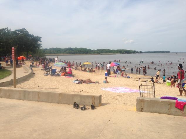
Rocky Point Beach, at the mouth of the Back River in Baltimore. Photo c/o Baltimore County.
Southern California’s Los Cerritos Channel has a small marina, which is used by rowing teams and is a popular fishing area. The nearby Colorado Lagoon hosts wildlife habitat and provides public recreation, including swimming. Dominguez Channel, meanwhile, has been the focus of a “greening” project to revitalize portions of the waterway and benefit local disadvantaged communities. And over on the East Coast, Baltimore’s Back River is home to numerous waterfront parks where locals have picnics and go windsurfing.
But these watersheds are legally designated as “impaired” because of high levels of nutrients, sediments, and toxic heavy metals like zinc and copper. That means they’re not clean enough to be safe for human contact or to support aquatic life.
Stormwater runoff from commercial, industrial, and institutional sites contributes a significant percentage of this pollution. These sites collectively occupy about one-quarter to one-third of the land area in each watershed. They tend to have large amounts of impervious area—mainly in the form of parking lots and rooftops—which produce runoff containing high levels of contaminants whenever it rains.
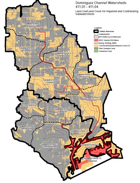
The Dominguez Channel watershed near Los Angeles. Yellow areas represent commercial, industrial, and institutional sites. Gray areas represent other types of sites. Image created by NRDC. (Click to enlarge.)
Government studies over the years have confirmed that commercial, industrial, and institutional stormwater discharges are a big part of local water quality problems. In fact, when it responded to our Dominguez Channel and Los Cerritos Channel petitions, EPA agreed with us that these three types of sites are contributing to copper and zinc contamination in the two California waterways. (The agency declined to make any determination, one way or the other, about the Back River watershed.)
According to the federal Clean Water Act, if EPA determines that a category of stormwater discharges is contributing to water quality violations, the agency must exercise its “residual designation authority” and require those dischargers to apply for permits. Those permits must then require the sites to limit the amount of pollution in their runoff, such as by mandating actions or steps that they must undertake.
So why isn’t EPA acting?
Despite its determination that commercial, industrial, and institutional sites are causing water quality problems in the Dominguez Channel and Los Cerritos Channel watersheds, the agency still refuses to require those sites to reduce their runoff pollution. Instead, EPA wants to rely on other regulatory approaches that just aren’t working.
And with regard to the Back River, EPA refuses to make any determination at all about whether these kinds of sites are contributing to violations, even though we provided the agency with unequivocal evidence that they are. In denying our Back River petition, EPA decided not to decide. But the Clean Water Act doesn’t give the agency that option.
Instead of requiring the sites causing the problems to obtain discharge permits and reduce their runoff pollution, EPA wants to continue depending on municipalities—like Baltimore and Los Angeles County—to clean up the mess. But local governments don’t control the sites generating the runoff, and they haven’t done a good job dealing with this pollution in the past.
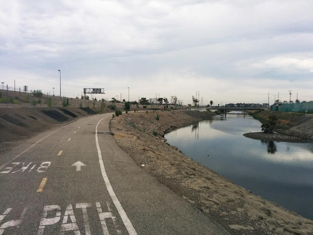
Bike path along the Dominguez Channel near Los Angeles.
Municipal stormwater permits in these watersheds contain loopholes that make it less likely discharges will be controlled enough to meet water quality standards. And local governments charged with carrying out these duties are falling behind on implementation and developing weak clean-up plans.
EPA’s claim that other programs are already addressing the problem isn’t true, and it isn’t a lawful justification for refusing to exercise residual designation authority under the Clean Water Act. Moreover, it isn’t fair: we need commercial, industrial, and institutional properties to clean up their own pollution instead of placing the financial burden on the backs of local governments and, by extension, taxpayers.
In the words of Gary Belan, senior director of clean water supply at our partner American Rivers:
“EPA lost an opportunity to require commercial, industrial, and institutional property owners to control stormwater on-site with proven, cost-effective green infrastructure practices that add benefits to the surrounding community. Instead EPA is leaving these municipalities to pay for the clean-up of polluted runoff that is produced on private property. American Rivers in collaboration with our partners seeks to have the EPA enforce the Clean Water Act and ensure that the polluter pays for the cost of clean-up, not the taxpayer.”
As Congress and the new administration attempt to roll back clean water protections, enforcing the safeguards we already have becomes even more important. Through these cases, we will seek to ensure that the government complies with the law, evaluates the evidence before it, and requires runoff pollution sources to do their fair share.
 Becky Hammer focuses on stormwater runoff, green infrastructure, low-impact development, water-pollution permitting issues, and climate change preparedness. Before joining NRDC in 2009, she interned at the U.S. Environmental Protection Agency. Hammer is a graduate of Harvard College and Harvard Law School. She is based in Washington, D.C.
This is a guest blog by Dana Romanoff.
Films provide the viewer a chance to enter someone else’s life and way of thinking and being. Making a film like Avanyu can do that for the director as well. This was apparent upon my initial meeting with Louie Hena, who is the main voice in the film. I was forced to take a step back, listen, and learn about another way of being.
Driving down from Colorado towards Santa Fe to meet up with Louie on a scouting trip, I called him asking for a specific time and meeting location. Instead of an address to plug into Google Maps, Louie instructed me to call each time I arrived at a certain town, specific store, or turn in the road, and he would direct me to the next step. Inching down the highway felt like a test of not only my navigational skills but of my perseverance and patience.
As I pulled into the traditional Tesuque pueblo, I saw the beautiful adobe buildings and let my lungs fill with the smell of sagebrush. I was reminded that I was entering someone else’s life and I had to step in softly.
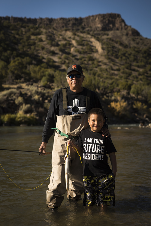
Louie Hena and his grandson fishing on the Rio Grande. | Dana Romanoff
In the film, Louie speaks to the western way of learning and schooling (history) vs. the traditional way. He remembers as a child attending western schools, switching classes with each bell. There was no connection between the subjects that were taught. At home his elders taught through song, dance, and story, and he learned that everything is connected.
The Rio Grande serves as a conduit for Louie and his family to connect to their ancestral knowledge and pass their stories along to the guests. The Native Family Feast and Float is as much about entering the landscape and culture of the Hena family and the Tesuque people as it is about floating down a beautiful section of the river. For the Hena family, the Rio Grande valley is their church. Guests learn the meaning of the canyon walls, the ancient history of this sacred place.
Louie explain that he hopes society will listen to and learn from indigenous people.
“More people around the world need to start listening to indigenous peoples and their communities and what they’re doing and help them out. Because what we do, we do it for Earth Mom. And if you look at Earth Mom, it’s one big basket, and we’re all the corn kernels in that one basket. So whatever happens to Earth Mom, we’re all impacted.”
Much of the water quality work on the Rio Grande and other rivers is based on the teachings of indigenous communities. Clean water is needed for sacred ceremonies as well as public health. Too often when we ignore traditional wisdom, the people suffer. The Standing Rock protest in North Dakota is a prime example.
As Louie says “I equate the health of my people with the health of my landscape – we heal the landscape and at the same time we heal ourselves.”
[su_youtube_advanced url=”https://youtu.be/JsdssG0B2FQ” rel=”no” https=”yes” width=”1020″ height=”520″]
Dana Romanoff is the Co-Director of Avanyu and DP of National Park Experience in Boulder, Colorado. Dana is a visual storyteller and producer whose images grace the pages of National Geographic and publications worldwide.
I first visited the unique, sculpted canyons of southern Utah on September 12, 2001, a day after the terror attacks that rocked the World Trade Center, the Pentagon, and Flight 93.
I had been teaching back-to-back outdoor education expeditions on the Green and Yampa Rivers in northeast Utah all spring and summer, and I needed a break. After postponing our trip on September 11 – we had just begun our drive south when the attacks occurred – to check on family and friends and to grieve with the rest of the world, a friend and I started our drive into Ed Abbey’s beloved landscapes on the afternoon of Sept 12, hoping to find solace.
A relatively unpopulated region to begin with, Utah’s canyon country was unusually empty of people at the time for obvious reasons. Due to the no-fly rule, not a single airplane dotted the sky for two days and nights. The weather was calm and crystal clear. Stars shone unimpeded overhead, owls hooted and coyotes serenaded without competition. Gurgling water echoed off of canyon walls.
Fifteen years later, my overwhelming memory of that trip is of the peacefulness, solitude and stillness that we experienced as we explored the canyons of Grand Staircase Escalante National Monument, created in 1996, and what would later become the Bears Ears National Monument, a half-day’s drive to the east from Grand Staircase.
Our experience was not unique
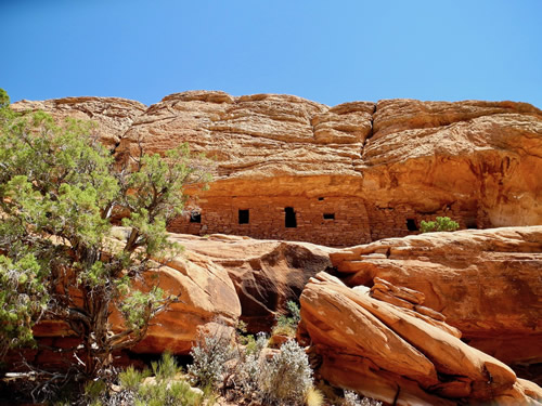
Multi-room Ancestral Puebloan ruin in Bears Ears National Monument. | Mike Fiebig
Public lands and rivers give us the space to celebrate, to grieve, to explore, and to reflect. In them, we learn to rely upon ourselves in ways that most of us don’t experience in our workday lives.
Coming upon hidden glens of dripping, maidenhair ferns croaking with canyon tree frogs, or 700-year-old Ancestral Puebloan ruins perched high above a river in a south-facing grotto, provide a much-needed connection to times and worlds beyond our own. In a nation as young as ours, forged by wild country and created in response to the landed nobility of Europe, these treasures are our Sistine Chapels, our open-aired museums.
Our public lands are quintessentially American: owned by all of us and democratically managed on our behalf for current and future generations. Public lands are an essential part of what makes this country great. They are the birthright of all Americans.
On December 28, 2016, President Obama designated 1.35 million acres of public land managed by the Bureau of Land Management [BLM] and U.S. Forest Service in San Juan County as the Bears Ears National Monument in order to preserve and protect sensitive archeological, ecological, and cultural resources.
This set of archeologically rich, high plateaus and canyons that feed the San Juan and Colorado Rivers with clean, desert snowmelt is now protected on our behalf by the two federal agencies plus a commission made up of elected officers from the Hopi Nation, Navajo Nation, Ute Mountain Ute Tribe, Uintah Ouray Ute Tribe, and the Zuni Tribe.
Your Public Lands are Under Attack
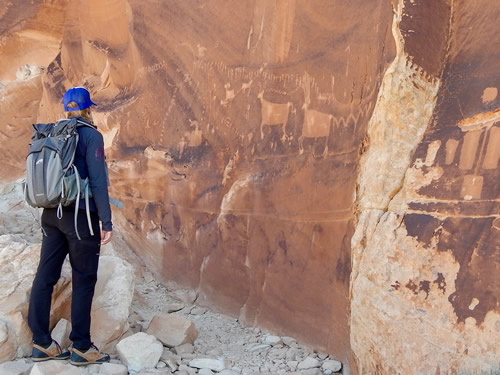
Petroglyph panel, Bears Ears National Monument. | Mike Fiebig
The unique canyons and rivers of Utah’s canyon country are also ground-zero in the movement to transfer our public lands to state and private interests, presumably in search of additional profits through sale and exploitation.
Bears Ears National Monument faces the threat of privatization and oil and gas development, while Grand Staircase-Escalante National Monument is in the crosshairs for a massive proposed coal mine.
Both are also threatened with de-designation as national monuments along with Cascade-Siskiyou National Monument additions in Southern Oregon. This has never happened before during the 110-year history of the Antiquities Act.
While mining, drilling, and development have their places, Bears Ears is not one of them. Bears Ears is home to one of the highest concentrations of backcountry archeological sites in the U.S. The incomparable canyons of the Escalante River, eligible for designation under the Wild and Scenic Rivers Act, are worth more than coal. Some of our most beloved national parks were first created through national monument designations: Grand Canyon, Bryce, Zion, Acadia, Olympic, Death Valley, Capitol Reef, and many others.
What are these lands worth to you?
What are these areas worth to us as a country, as a culture, as Americans? American Rivers is dedicated to protecting your national public lands and rivers from transfer, sale or degradation. We need your help.
Tell your Congressional delegate that you want to maintain your birthright as an American. Our public lands, including Bears Ears and Grand Staircase Escalante National Monuments, should stay public and intact.
[metaslider id=36266]
Public safety must be the number one priority at Oroville Dam. Sheriff Kory Honea lifted the mandatory evacuation on Tuesday, but correctly warned that residents should be prepared to evacuate again if the situation deteriorates.
Since Sunday evening when California’s Department of Water Resources [DWR] announced that the collapse of the auxiliary spillway was imminent, I have been trying to understand the potential magnitude of the catastrophe that might result if the auxiliary spillway collapses. Fortunately, DWR was able to increase releases to the main spillway and avert a catastrophe for now, but that has left me wondering how bad it could get.
In the hopes of helping downstream communities prepare for the worst, our team at American Rivers has attempted to describe some plausible scenarios for the days and weeks ahead. With the limited information we were able to gather on the dimensions of the spillways, we attempted to estimate the potential size of another spill event. Since we don’t have perfect information, we could be wrong and we invite our readers to point out any flaws in our reasoning or estimates.
DWR’s heroic efforts to repair the emergency spillway are worth the effort, and we should be thankful for their tireless efforts, but we really don’t want to test whether the repairs will work. It is prudent to assume that they won’t work, resulting in a breach of the spillway crest. The next question is how big the breach will be since that will determine the rate of flow over the broken spillway.
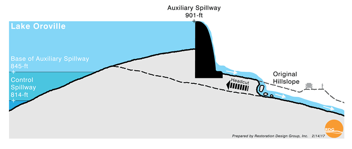
Figure 1. Click to enlarge.
Figure 1, developed by our friends at Restoration Design Group, illustrates how erosion could undercut the auxiliary spillway weir, which is 1730 feet wide, 30 feet high on the lake side of the spillway, and as much as 50 feet high on the downhill side.
The close-up photograph of the spillways (figure 2) also shows the relative elevation of the main spillway gates and the auxiliary weir crest. The reservoir covers a 16,000 acre area (Figure 3), and by our estimates as much 930,000 acre feet of water could rapidly flow out of the reservoir during a breach of the auxiliary spillway (Figure 4). Far more would rush out if the main spillway failed.
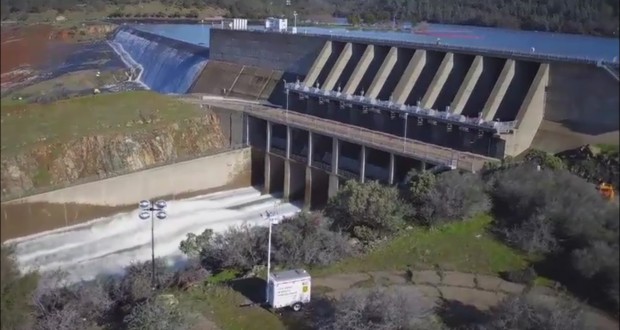
Figure 2: View looking North shows the main spillway control gate structure in the foreground and the eauxiliary spillway in the background.
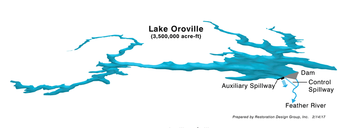
Figure 3. Click to Enlarge.
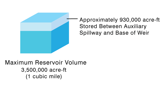
Figure 4. Click to enlarge.
Since the mechanism of failure is undercutting, it is possible that an overtopping event would create a very large breach that would effectively function as a weir since it is at the top of a hillside.
All the water above the bottom of the breach would rush over the auxiliary spillway, but the rate of flow, measured in cubic feet per second, or cfs, would depend on the size of the breach. You can use this weir equation to see how different assumptions about the width and height of a breach would affect the discharge. Your guess on the size of the breach is probably as good as ours, but consider the following scenarios:
Scenario #1 – Disaster Averted: The best and the most plausible scenario is for DWR to avoid another spill event.
Scenario #2 – Reservoir Spills but Spillway holds: Even if the crest holds, it could be bad if the peak inflow enters after the reservoir is full as described in my earlier post.
Scenario #3 – Moderate Breach in Auxiliary Weir Crest: Overtopping of the weir crest creates a breach 500 feet wide and 30 feet deep.
Scenario #4 – Major Breach in Auxiliary Weir Crest: Overtopping of the weir crest creates a breach 1,000 feet wide and 30 feet deep.
Scenario # 5 – Failure of the Main spillway: Overtopping of the weir or excessive use of the main spillway causes failure of the main spillway gates and a major notch 167 feet wide and 90 feet deep.
The table below summarized the scenarios and expected discharge using a weir equation.

The design capacity of the Feather River floodway is 210,000 cfs (CA flood management picture), but it hasn’t really been tested in recent memory except in 1997 when releases from the dam were 150,000 cfs and downstream levees broke. Since then, as described in my previous blog, the floodway has been expanded and the levees improved, but it is very unlikely that it could contain flows resulting from any of the breach scenarios.
On the low end of the spillway failure scenarios, one or more levee breaches will most likely occur along the Feather River, flooding populated areas like Yuba City where 60,000 people live. On the high end of the range, the results would probably be catastrophic. I won’t speculate too much about where the water will go and how much it will erode or spread out, but suffice it to say that I would evacuate if I lived in the floodplain of the Feather River or Butte Basin, and I would pay careful attention to the situation if I lived in the low lying areas of Sacramento.
The key factors will be temperature, precipitation, inflows to Oroville, the integrity of the spillways and associated repairs, and the size of a breach that could open up if one or both spillways fail. More precipitation is forecast over the Feather River continuously through at least Tuesday. Fortunately, it looks like it will be both cooler and lighter than the last storm. If inflow stays below or equal to outflow (which has been 100,000 cfs), then DWR should be able to avert a disaster. Between Sunday evening and Wednesday evening, DWR evacuated 360,000 acre feet, which is very close to my estimate. If inflow starts to exceed controlled releases by a significant amount though, the reservoir could fill and spill within a matter of days.
My hope is that we can avoid a disaster this year and learn the lessons necessary to avoid future disasters as climate change makes these extreme events more common. Over the weeks and months ahead, I will be blogging about the 2017 update to the Central Valley Flood Protection Plan and the lessons learned over the last five years as American Rivers worked with DWR, the Central Valley Flood Protection Board and many other dedicated partners on this progressive plan. For now, I will sign-off with my mantra: giving rivers more room to safely carry flood waters is the best way to protect people and property from floods.
Erik Stromberg, ASLA, contributed to this piece.
The situation at the Oroville Dam in California right now illustrates the need to seriously consider public safety in dam planning and management. Today we are celebrating all of the dams that were removed in 2016! These former barriers will no longer pose any safety hazard to the public.
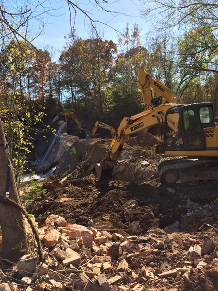
Removing Shuford Dam in North Carolina. | Erin McCombs
Communities in 21 states, working in partnership with non-profit organizations and state and federal agencies, removed 72 dams in 2016, restoring more than 2,100 miles of streams to benefit public safety, local economies and our nation’s natural heritage. American Rivers played a role in 18 of the dam removals on this year’s list.
Check out our updated interactive map of dam removals!
Dams were removed in the following states in 2016: California, Colorado, Connecticut, Illinois, Indiana, Massachusetts, Michigan, Minnesota, New Hampshire, New Jersey, New York, North Carolina, Oregon, Pennsylvania, Texas, Utah, Vermont, Virginia, Washington, West Virginia, and Wisconsin.
Have you witnessed any dam removals this year? Please tell us about your experience!
In 2016, Pennsylvania had the highest number of removals for the fourteenth year in a row. The top three states removing outdated dams in 2016 were:
- Pennsylvania – 10 dams removed
- North Carolina – 8 dams removed
- Minnesota– 6 dams removed
According to the Association of State Dam Safety Officials, America’s dams are degrading faster than they are being repaired, the number of high hazard dams has increased over time, and the cost to rehabilitate dams continues to rise. By 2020, seventy percent of dams in the United States will be more than 50 years old. Aging dams can pose a serious safety threat for individuals and entire communities.
River restoration also delivers economic benefits. A 2012 study found that every $1 million spent on Massachusetts Division of Ecological Restoration projects resulted in 10 to 13 jobs created or maintained. A 2010 study in Oregon found that every $1 million spent on forest and watershed restoration resulted in 15-23 new jobs and $2.1 – 2.3 million in economic activity. The economic benefits of dam removal are summarized in a 2016 report by Headwaters Economics.
American Rivers is the only organization maintaining a record of dam removals in the United States. The database includes information on 1,384 dams that have been removed across the country since 1912. Most of those dams (1,174) were removed in the past 30 years. The list includes all known dam removals, regardless of the extent of American Rivers’ involvement.
Highlights of dam removal and river restoration efforts in 2016 include:
Ottine Dam, San Marcos River, Texas
This 108-year old dam was damaged by a storm in 2008 and had been a safety hazard in the San Marcos River ever since. Dam removal restored 39 miles of river, benefitting kayakers and canoeists as well as fish and wildlife. Boaters participating in the Texas Water Safari annual race from the San Marcos headwaters to the coast will no longer be required to carry their equipment up and down a steep incline to bypass the dam. Texas Parks and Wildlife Department is considering adding the restored stretch of river to the paddling trails system for Palmetto State Park. For more information: https://www.fws.gov/southwest/docs/OttineDamNR012016.pdf
Hogansburg Dam, Saint Regis River, New York
Following the decision that re-licensing of the Hogansburg Project was cost-prohibitive, the Saint Regis Mohawk Tribe led the removal of the 281-foot long and 12-foot high Hogansburg Dam. Completion of the project marked the first removal of a federally-licensed dam in the U.S. by a Native American tribe, and the first removal of a hydropower dam in New York State. As the first impassible barrier to fish on the St. Regis River, removal of the dam restored access to 555 miles of stream habitat and returned project land to the Saint Regis Mohawk Tribe. For more information: https://www.srmt-nsn.gov/environment/hogansburg-dam-removal
Shuford Mill Dam, Henry Fork River, North Carolina
The Shuford Mill Dam, formerly a 35-foot tall, 275-foot wide masonry and concrete dam on the Henry Fork River in Brookford, North Carolina, had outlived its usefulness. It was constructed in the late 1800s to power an adjacent textile mill, which closed years ago. Dam removal eliminated the public safety risk posed by the unmaintained dam, improved the local community’s access to safe recreation on the Henry Fork River, and restored ten miles of river habitat for fish and wildlife. This project is an excellent example of partnership among American Rivers and other non-profit, state and federal partners. For more information: https://www.americanrivers.org/2016/08/shuford-dam-removal/
Hughesville Dam, Musconetcong River, New Jersey
The removal of Hughesville Dam, the lowest blockage on the Musconetcong River, helps restore fish and wildlife and water quality in this federally designated Wild and Scenic River. Dam removal restored access to two miles of historic river herring spawning and nursery habitat, and will benefit American shad, alewife and American eel. The Musconetcong Watershed Association coordinated work with property owners, engineers, contractors and partners including U.S. Fish and Wildlife Service, the New Jersey Department of Environmental Protection, American Rivers and others. For more information: https://www.musconetcong.org/hughesville
For more information on these and other 2016 removals, please see our full list.
Guest Blogger: Guy Jones, Owner, River Runner Outdoor Center in Columbia, South Carolina
Three decades ago, my hometown river, the Saluda near Columbia, South Carolina, was threatened by a proposed hydroelectric dam. Working with dedicated community leaders, I ran canoe trips on the Saluda in an effort to bring attention the harmful project and to highlight the river as a recreational asset. These efforts not only stopped the dam project in its tracks, they also led to the creation of River Runner Outdoor Center, the first full service outfitter center in Columbia, where I met my wife when she came to buy a kayak.
Since then, I have been living my dream of connecting people to the Saluda, Broad and Congaree rivers through recreation. River recreation is increasing in Columbia and across the country. We’re seeing communities working to improve river recreation and protect their rivers through the creation of Blue Trails. These Blue Trails are rivers adopted by a community dedicated to family-friendly recreation and conservation. And we’re seeing this giving a boost to local economies.
The Congaree River Blue Trail in Columbia is a shining example. This 50 mile trail offers opportunities to experience the area’s rich natural resources and wildlife through boating, fishing and other activities. The highlight of the trail is Congaree National Park, home to the largest tract of old growth bottomland hardwood forest in the U.S. It connects urban and rural communities and youth to this treasured landscape. Since the creation of the Congaree River Blue Trail, I have seen a spike in the number of people enjoying the river through recreation. And enjoyment and protection of the great outdoors is simply downright valuable.
The fight to protect our nation’s wild rivers begins today.
Together with our partners, we are launching a new campaign, 5,000 Miles of Wild™.
[su_youtube_advanced url=”https://youtu.be/agPz0M9YZCE” rel=”no” https=”yes” width=”1020″ height=”520″]
It’s about saving the best of our nation’s wild, free-flowing rivers, at a time when they face serious threats – from public land giveaways to the roll back of critical clean water protections.
Not only are American Rivers and our partners mobilizing to oppose threats to rivers and clean water, we are advancing a positive vision for wild rivers — building a movement of Americans who love wild rivers and want to see more rivers protected for their kids and grandkids.
Our goal is to defend existing Wild and Scenic Rivers from threats and protect 5,000 new miles of Wild and Scenic Rivers and one million acres of riverside lands.
Why now?
Because we must come together to oppose plans that put polluters and and powerful special interests above the health and well-being of ordinary Americans and the health of the rivers that run through our lives.
And, because next year, 2018, is the 50th anniversary of the Wild and Scenic Rivers Act – a landmark law that safeguards outstanding rivers for their recreation, clean water, cultural, historic, fish and wildlife and other values.
We’re excited to have the support of business partners NRS, OARS and Yeti Coolers. We’re fired up and we’re ready to get to work.
Now is the time: To share your story about why rivers matter to you. To take action in support of river protection. To stand up for the rivers you love.
Join us: share your river story »
Over the weekend the situation at Oroville Dam went from bad to worse. The Sacramento Bee headline said it best: “Nature is in Control.” In response to revelations that the emergency spillway might fail catastrophically, the Butte County Sherriff heroically took charge and ordered an evacuation Sunday afternoon that eventually expanded to include three counties and 188,000 people.
One thing is certain, this story will continue to unfold for at least a week, because the rain forecast for later this week will exacerbate the situation. The worst case scenario would be for the evacuated population to return to their homes before it is safe. Thousands, perhaps tens of thousands of lives would be at risk. Given the extensive damage to both the emergency and main spillway, it would be unsafe for evacuated people to return home before the Department of Water Resources (DWR) is able to evacuate the reservoir to safe levels. DWR says they want to lower the reservoir by 50 feet, and this would be necessary to comply with the US Army Corps of Engineers rule curve for the dam.
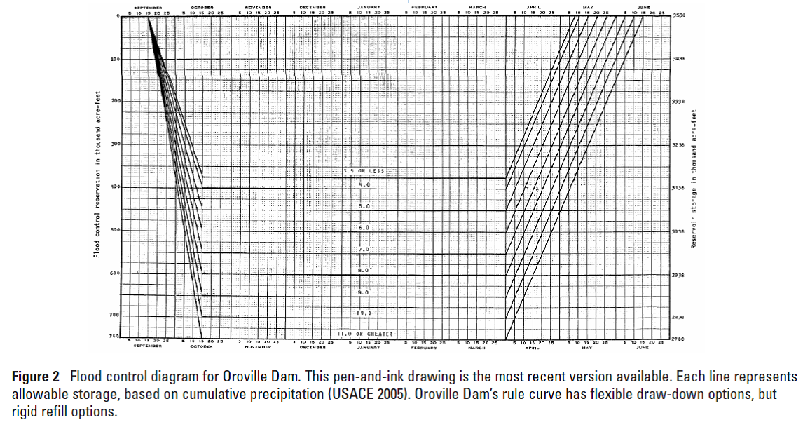
Yes, there is a rule curve (figure 1 below) for the dam and thanks to the spillway fiasco, DWR is radically out of compliance with the rule curve as shown in figure 1 below. To prevent a disastrous downstream flood, it requires DWR to keep the reservoir level relatively low in the rainy season to make sure there enough space to accommodate large flood events. During wet years like this one when the soil is saturated, DWR is required to maintain 750,000 cfs of empty space in the reservoir through April 1 to capture flood flows. If you really want to geek out on how we should adjust rule curves to better adapt to a changing climate, check out the this UC Davis research paper on the subject.
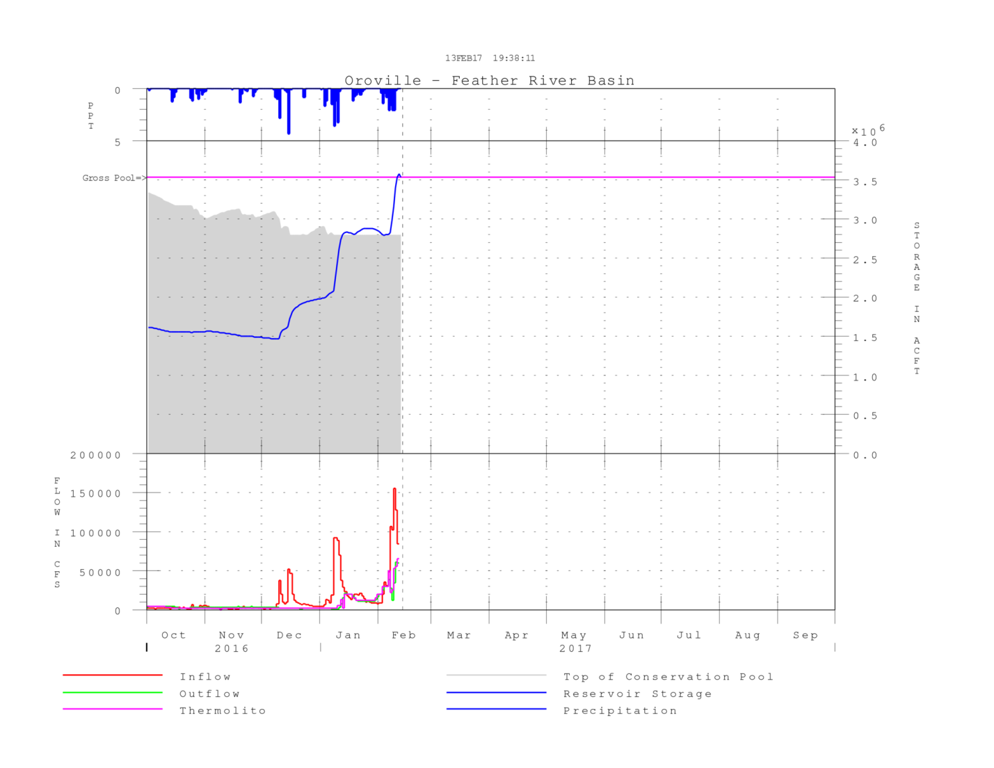
Figure 1: The grey area shows the maximum allowable flood stage (top of conservation pool). According to the reservoir rule curve, the remainder of the reservoir space, the area between the grey zone and the top pink line (gross pool) is reserved for capturing floods (flood pool). Note how reservoir storage rocketed above the allowed conservation pool and over the gross spill (emergency weir crest) in the last few days due to temporary suspension of releases from the damaged spillway. The size of the allowed conservation pool (the grey area) gradually declined since the beginning of the water year, because under the rule curve (see below) the size of the required flood pool is proportional to antecedent precipitation. Click on this link to get and update on this graph.
As of last night, DWR had zero extra space in the reservoir and the math for DWR’s prospects of complying with the rule curve in the next ten days is not good. DWR is currently releasing 100,000 cfs down the main spillway, while inflows continue at 40,000 cfs. The net outflow of 60,000 cfs will evacuate about 120,000 acre feet per day (1 cfs per day equals 2 acre feet), but rains are expected to return by Wednesday evening. At the current rate, they only will be able to evacuate 360,000 cfs before inflows start to spike again.
Heavier rains starting Friday and predicted throughout the weekend could fill the reservoir to the brim by the end of next week. If inflows rebound to 130,000 cfs and DWR holds releases at 100,000 cfs, the reservoir will fill within 7 days. During the six peak days associated with the last storm, the daily average was 104,000 cfs, which provides some hope that DWR will be able to stop the reservoir from filling. Fortunately, the forecast is for lighter, cooler precipitation then the last week’s storm.
Given the moderate storm forecast through next Monday, the best case scenario is for the weather to dry out next week enabling DWR to comply with the rule curve by next Thursday or Friday. While this would avert a catastrophe, it means that the evacuated population will have to wait until the later part of next week to safely return home. Allowing people to return before the DWR complies with the rule curve risks the need to re-evacuate if the weather takes a turn for the worse, and the second evacuation attempt would inevitably meet resistance, increasing the chance that many people refuse to leave.
Fortunately, there is now reason for hope that the worst is behind us, but the probability of the situation deteriorating again is still too high. If the rains this weekend turn out to be significantly greater than forecasted, or if the wet weather persists, some very dangerous flood scenarios could still arise. I will describe some of those scenarios in my next blog before it rains again.
It’s tough being a conservationist these days.
With each passing day, the new administration and Congress announce another environmental rollback. Right out of the gate they scrapped the Obama administration’s stream protection rule, which stopped coal mining companies from removing mountaintops and dumping the spoils in our streams. Then a Florida congressman introduced a bill to abolish the Environmental Protection Agency (EPA). Then a Utah congressman introduced a bill to transfer three million acres of public lands in ten western states from the federal government to the states, where they would be able to sell them off.
That latter action was too much to swallow for residents of the West, who view public lands as a sacred birthright. So we did what any good democracy-loving Americans would do – we marched on our state capitols by the thousands and made it clear to our elected officials that they had touched the third rail. I held up a sign saying, “You can pry our lands from my cold, dead hands,” and as someone who recreates on our public lands almost every day, I meant it.
American Rivers’ Northern Rockies office co-sponsored the public lands rally in Helena, Montana, where more than 1,000 Montanans mobbed the capitol rotunda to make their voices heard. Fortunately for us, we didn’t have to convince our governor, Steve Bullock, that selling off our public lands is a terrible idea. As you can see from this video, he led the charge.
Just a few days after the public lands rally in Helena and another boisterous rally in Sante Fe, New Mexico made national news, the sponsor of the bill that would have transferred three million acres of federal lands to the states, Rep. Jason Chaffetz (R-Utah), abruptly announced on his Instagram page that he was pulling his bill. He had whacked a hornet’s nest, and he knew it.
While public lands advocates won the first skirmish of the 115th Congress, we fully expect even worse legislation to be introduced over the next two years. Sadly, there is no shortage of compromised politicians who would sell off our national parks, national forests, BLM lands, and Wild and Scenic Rivers to their friends in the extractive industries so they can cut more timber, mine more coal, drill for more oil and gas, and pollute our rivers and streams. They are well funded, but they are also vastly outnumbered – if we make our voices heard.
Please help us keep our 640 million acres of federal public lands in public hands by emailing your members of Congress here. Better yet, call your members of Congress and tell them that you oppose all efforts to sell off or transfer management of our federal public lands. For as those of us who marched in Helena and Sante Fe just learned, if enough of us yell loud enough, the scoundrels will head for the hills.
Water from heavy storms in California throughout January finally started to reach the San Joaquin Valley over the past several weeks. The delay in the flood peak was due to the last 5 years of drought. There was barely any water in the large reservoirs that feed the Lower San Joaquin River, so they had enough room to capture the runoff from this year’s first series of storms. In preparation for a sequence of new storms that moved in a few weeks ago, these reservoirs had to start spilling some of this captured water to create more room for the incoming runoff. As a result, flood peaks in the San Joaquin River came more than a week after the initial storms that hit the state.
[metaslider id=35934]
Wanting to document one of our floodplain restoration projects on the San Joaquin River, I closely watched the flow forecasts online to time my visit. On MLK Day, I was able to make it down close to the flood peak with a main goal of documenting flood conditions with our drone. It was impressive to be out during the highest flow since 2011. Water was only six feet below the tops of the levees that form the state floodway – a narrow corridor made up of levees along both sides of the river. This floodway was built by the state and federal governments earlier in the 20th century to contain the river and convey flood flows.
Did you know that in California we have levees that block rivers from accessing floodplain habitat on state and federal park and refuge lands? The dry triangular wedge of land in the middle of all the flooding is Great Valley Grasslands State Park. This state park, part of the largest remaining area of unplowed native grasslands in the entire Central Valley, lies approximately 1.5 hours due South of Sacramento. The aerial perspective allows for a unique view, and due to the flooding, poignantly illustrates the artificial disconnect between the river and its floodplain.
Cutting rivers off from their floodplains is very harmful and causes many problems; foremost among them is increased flood risk and habitat degradation. Levees along rivers throughout the Central Valley have constricted river corridors and cut them off from their floodplains. This artificial constriction raises water surface levels and increases flood risk because it reduces the capacity of the river to carry water. Rivers need more room in order to safely and more effectively accommodate floods. This is especially important in an era predicted to be characterized by an increased frequency of extreme flood events.
Natural flooding within the adjacent San Luis National Wildlife Refuge shows what historic floodplain wetlands within Great Valley Grasslands State Park lands used to look like. | Daniel Nylen
In partnership with California State Parks, the U.S. Fish and Wildlife Service, the local levee district, River Partners, and Ducks Unlimited, American Rivers is leading a restoration project that will remove sections of levee to reconnect up to 200 acres of historic floodplain and native grasslands within the park. By giving the river more room and re-connecting its floodplain, water will more frequently flood the floodplain. This provides multiple benefits including reductions in flood risk, re-establishment of native grasslands adapted to periodic flooding, groundwater recharge, and improved habitat for fish and wildlife. Not only will we be restoring habitat on public land, but we will also be helping the local levee district to save money by reducing maintenance costs.
This project provides a scalable example of the multi-benefit flood management approach that American Rivers and its partners are promoting and beginning to implement on a larger scale within the Central Valley. This approach not only reduces flood risk for people and communities, but can also help make tangible strides toward ecosystem recovery goals. American Rivers is also leading numerous other model projects throughout the San Joaquin and Sacramento Valleys to support state level flood management policy reform. This nature-based model of flood management is not only relevant to California’s Central Valley, but is also replicable in regions elsewhere that are dealing with outdated flood management systems and infrastructure.
By now you may have read the alarming news about the spillway at Oroville Dam – a 770-foot tall engineered earthen dam, the tallest dam in the United States and one of the tallest earthen dams in the world. The reservoir behind the dam is expected to fill early Saturday morning and potentially spill over an emergency spillway that has never been used since the dam was completed in 1968. As one twitter user observed, “the emergency spillway is basically a hillside.”
The good news is that the weather is clearing today with sunny weather forecasted into the middle of next week. Peak inflows into Oroville Reservoir are receding rapidly. Experienced engineers from the California Department of Water Resources and the Central Valley Flood Protection Board have assured the public that there is no risk of dam failure. Since yesterday afternoon, inflows have decreased from 185,000 cubic feet per second (cfs) to 140,000 cfs this morning, while outflows were ramped up to 65,000 cfs using the damaged spillway combined with the power house outlet.
There is a good chance that inflows and outflows will achieve equilibrium by some time this weekend. This morning, the reservoir was holding 3,461,356 acre feet of water, which is 98 percent of capacity. At current net inflows, the reservoir will start spilling onto the emergency spillway early Saturday morning, but if inflows continue to recede, the flows into the emergency spillway should be relatively small and short-lived. That is the good news.
The bad news is that more rain is forecast for next week. If the reservoir fills before the next peak, which is still a big if, all inflow to the reservoir would flow out over the spillway and into the Feather River. Depending on the size of the next runoff event, this could be a big problem not only on the emergency spillway, but for the downstream communities along the Feather River, particularly Marysville and Yuba City. The National Weather Service reports that next week the “wet pattern returns Wednesday into next weekend as models show another series of storm systems moving across California.” They are currently forecasting moderate rain, but if they upgrade that to heavy rain, we are in trouble.
Inflows to the reservoir peaked at 190,000 cfs this week. If the reservoir had been full, all of that 190,000 cfs would have flowed down the untested emergency spillway and into the Feather River floodway, where it would be joined by another 10,000 cfs or more from local drainages. The design capacity of the floodway is 210,000 cfs and would have theoretically been able to accommodate such an event, but it would have been 25 percent larger than the record flood of 1997 that peaked at just over 150,000 cfs below Oroville Dam as reported by Maurice Roos, the former state hydrologist.
That flood as reported here breached the levee, killed 3 people, destroyed 322 homes, and triggered the evacuation of 38,000 people. If the reservoir had been full when the 1997 peak reservoir inflow of 300,000 cfs occurred, the ensuing destruction would have made Hurricane Katrina look feeble.
I will end with some good news: since 1997, local, state, and federal governments have worked effectively with each other and conservation organizations to give the Feather River more room to accommodate the large floods we know that climate change will bring. Instead of denying climate change, state leaders of both parties worked together to marshal taxpayer support for Proposition 1E in 2006 after the nation witnessed Katrina. Thanks to effective government partnerships, levees and floodways have been significantly improved around Yuba City and Marysville and the floodway has been significantly expanded along the Feather River where floodwaters previously backed-up at a bottleneck in the system.
Levee setback projects at the confluence of the Bear and Feather Rivers, Star Bend, and along seven miles of the east bank of the Feather River have given the river more room to accommodate any additional floodwaters the next few weeks or decades might bring as we adapt to a changing climate.
These projects not only save lives, but they provide multiple other benefits that improve the quality of life for people living in the region. They improve water quality, provide open space and recreational opportunities for local communities, and improve habitat for fish and wildlife. Due to taxpayer investment after Hurricane Katrina, flood agencies have successfully worked with American Rivers and other conservation groups to identify many additional multi-benefit projects across the Central Valley that are necessary to protect lives and safeguard our economy in an era of climate change.
Unfortunately, Proposition 1E is now fully spent and committed. If we are serious about protecting our rivers and communities from a changing climate, we will need to find additional funds and work cooperatively to make sure they are spent effectively.
Flood, like fire, is important to ecosystem health but dangerous when our pride leads us to believe we can control it. Many people now know that Smokey the Bear was only partially right about forest fires. Humans should avoid carelessly starting fires, but periodic fires are natural, inevitable, and often beneficial. Over a century of fire suppression in the western United States has led to unchecked vegetation growth that has fueled catastrophic and harmful fires. Frequent, low intensity fires, on the other hand, reduce understory brush fuels and nourish forest soils.
Floods and flood control are very similar. Human efforts to “control” floods have mostly eliminated small to moderate flood events while potentially worsen the damage from the largest floods. Seasonally inundated floodplains provide essential habitat for fish and wildlife, but levees and dams in California’s Central Valley have all but eliminated these beneficial small to moderate floods, driving several species to the brink of extinction. While levees and dams have succeeded in eliminating beneficial flood events, they are vulnerable to catastrophic failure during the largest of floods.
Levees, dams, and national flood polices have lured people into harm’s way. By controlling and eliminating the smaller floods that once spread out across floodplains in wetlands during annual to decadal floods, they have created the false impression that floodplains are suitable places to build new subdivisions, schools, and other public infrastructure. When large floods inevitably overwhelm the capacity of the flood system, levees break and catastrophically flood communities. We all witnessed this when Hurricane Katrina devastated New Orleans. Catastrophic levee breaches similarly devastated some Central Valley communities in 1955, 1986, and 1997.
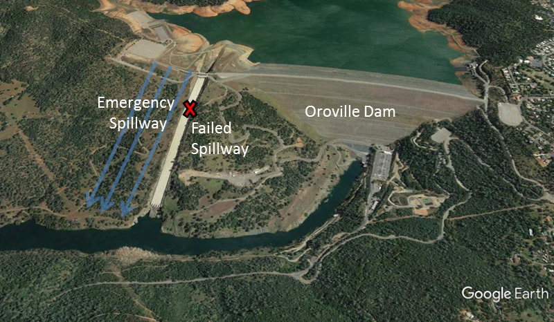
Map indicating the failed spillway’s location compared to Oroville Dam.
California’s Central Valley flood “control” will be put to the test over the next few weeks as reservoirs fill and rains continue to fall on saturated soils. We are already beginning to see some alarming signs that the system may not hold up. On Tuesday, the California Department of Water Resources reported that the spillway at Oroville Dam, the tallest earthen dam in the US at 770 feet high, was failing. Authorities and experts claim there is no risk of dam failure, and I hope they are right. An emergency spillway immediately to the north of the existing spillway should be able to accommodate the overflow, but it has never been used in the half century since the dam was built and entails sending a large volume of water down an unarmored hill side.
The problem with the Oroville Dam spillway is probably just the first sign that the Central Valley flood system will require hundreds of millions of dollars in repairs after the 2017 runoff season is complete. Even if the rains let up soon, months of high runoff will create major wear and tear on the state’s levee system. After the high water years of 2005 and 2006, the state and federal government spent hundreds of millions of dollars repairing levees, often times by dumping rock along river banks and in wetlands. These “repairs” however, were little more than expensive and environmentally harmful band aids. We need to do better to protect people, property, and the environment.
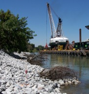
A crane works to repair a broken levee.
As an added layer, climate change will bring larger floods in the future, particularly to the San Joaquin Valley. We need a more resilient flood management system that can accommodate large floods and rebound naturally without large amounts of human investment or environmental disruption. Levees and dams are the opposite of resilient – they work until they fail. And when they do fail the consequences can be catastrophic – leading us to do harmful and expensive “repairs” to our rivers, further perpetuating the cycle of vulnerability and destruction.
Giving our rivers more room to safely accommodate large floods is the best way to protect our communities from flooding. Giving rivers more room also provides multiple other benefits including clean water, groundwater recharge, open space for recreation, and wetlands that cleanse water for fish, wildlife, and people. The draft 2017 Update to the Central Valley Flood Protection Plan emphasizes the importance of multi-benefit flood management projects and prioritizes floodway expansions near urban areas on the lower Sacramento and San Joaquin Rivers. American Rivers and our partners are now designing several of these multi-benefit projects to give Central Valley rivers more room.