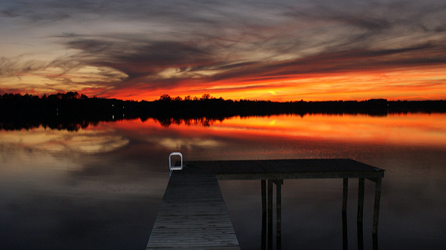
The communities of eastern North Carolina are still reeling in the aftermath of yet another historic amount of rain and flooding than has ever been seen before. Thousands of families are still trying to get back to their homes and communities are pulling together to support each other. The water is finally receding and the support networks of the government and non-profit organizations are on the ground providing help.
This story is unfortunately not uncommon to us. In 2016, Hurricane Matthew dumped 20 inches of rain on the region. The spring of 2017 saw huge rain events in the piedmont area that turned small creeks into raging torrents of water filling the rivers of eastern North Carolina to the brim and inundating floodplains. The 35+ inches of rain that fell in the area around Elizabethtown, NC during Hurricane Florence is the latest mark and almost rivals the rain falls we saw in Houston during the drenching of Hurricane Maria. These new normals are part of the story of climate change that includes more frequent and violent storms which is clearly our reality now.
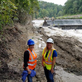
In 2017, American Rivers listed the Neuse and Cape Fear Rivers as the #7 Most Endangered River due to the threat of industrial farm waste lagoons and piles in the floodplain. North Carolina has over 3,300 hog waste pools and innumerable amount of dry litter piles from poultry operations. Within the 100-year floodplain of the coastal counties there are 62 hog operations and at least 30 poultry operations. The hog operations have 166 open-air waste lagoons directly within the 100-year floodplain, and another 366 within 100 feet of the floodplain. The floodwaters of Hurricane Florence inundated many farm operations, killing the animals and releasing waste into the floodwaters.
There is a buyout program for the agricultural facilities that was started after Hurricane Floyd in 1999 and it has been successful when it has been funded. According the N.C. Pork Council more than 330 hog waste lagoons that had been in the floodplain have been closed down and cleaned out through that program. But it is time to move all of this waste out of the floodplain.
There is more than just animal operations in the floodplain, there are threats from coal ash ponds, community waste water treatment plants, and industrial operations all sited and sitting in the floodplain. Many were inundated during the overwhelming floods North Carolina saw in the aftermath of Hurricane Florence. Our new normal requires us to develop a plan to get these threats out of the floodplain so that when the rivers rise and the floodplains fill we don’t add to the threat to communities by creating a toxic surge of water that coats the flooded areas.
October 2 marks the 50th anniversary of the Wild and Scenic Rivers Act, one of our nation’s landmark conservation laws.
The golden anniversary of the Wild and Scenic Rivers Act provides a unique opportunity to celebrate the importance of rivers in our country, and commit ourselves to their protection for the next 50 years.
The National Wild and Scenic Rivers System safeguards beloved places that define us as a nation. The ‘shot heard ‘round the world’ was fired over the Wild and Scenic Concord River in Massachusetts. Nebraska’s native prairie still thrives along the Wild and Scenic Niobrara River. Wild salmon return every year to the Wild and Scenic Rogue River in Oregon. Lewis and Clark would still recognize the Upper Missouri River in Montana.
Millions of people in New York, Pennsylvania, California and other states turn on their faucets every day and enjoy clean drinking water, thanks to the protection of Wild and Scenic Rivers such as the Upper Delaware and Tuolumne.
Together, we will write the next chapter for river conservation in our country. We must prioritize the protection of wild, free-flowing rivers in collaborative, bipartisan ways that benefit all of us – particularly historically marginalized communities and communities of color. Now is the time to act, because healthy rivers make us more resilient to the impacts of climate change by providing reliable, clean water supplies and natural flood protection. Wild and Scenic Rivers also offer unsurpassed opportunities for recreation and connection with each other and the natural world.
When he signed the Wild and Scenic Rivers Act in 1968, President Johnson said, ‘Every individual and every family should get to know at least one river.’ Rivers connect us to our past and our future. American Rivers is committed to supporting and growing the National Wild and Scenic Rivers System to ensure a rich legacy of wild rivers for generations to come.
Some key facts
The Wild and Scenic Rivers Act was championed by Secretary of the Interior Stewart Udall and signed into law by President Lyndon Johnson on October 2, 1968. It is unique in the world and remains the most powerful tool for protecting rivers, by prohibiting dams and other harmful development along the designated reaches.
Today, the National Wild and Scenic Rivers System safeguards nearly 13,000 miles along parts of 209 rivers and 3,000,000 acres of riverside land in 40 states and the commonwealth of Puerto Rico. See https://www.rivers.gov/map.php
We’re making progress
American Rivers and the 5,000 Miles of Wild® campaign are working to protect 5,000 new miles of Wild and Scenic Rivers and one million acres of land nationwide.
The nation’s newest Wild and Scenic River is East Rosebud Creek, part of the Yellowstone River watershed in Montana. President Trump signed the bipartisan legislation into law in August. Current grassroots Wild and Scenic designation efforts include the Nooksack River in Washington, the Gila River in New Mexico, Montana’s Greater Yellowstone Ecosystem, the Oregon Wildlands with protections for the Molalla and Rogue rivers, and the Wild Olympics, with protections for rivers including the Elwha and Sol Duc.
The 5,000 Miles of Wild® campaign is supported by American Rivers, American Whitewater, Pacific Rivers, NRS, OARS, YETI, REI Co-op, Chums, Chaco, Nite Ize, Kokatat, Yakima, and KEEN.
In Episode 13 of We Are Rivers, we explore how fire suppression has triggered today’s newsworthy mega-fires and how intricately connected wildfires are with the health of the rivers we love.
On the weekend of 4th of July, while most people were enjoying a sunny holiday with friends and family, barbequing, and relaxing, my best friend was packing up her mom’s wedding dress, her late grandmother’s hand-me-downs, and baby pictures into a cardboard box in her Basalt, Colorado home. White ash rained from the sky around her and helicopters darted in the sky above while she carried the keepsakes to her car. She was hastily choosing what belongings to save as a wildfire encroached on her house. I was in New York at the time, and we talked over the phone amidst the chaos. Her voice cracked as she asked, “What if I’m leaving my childhood home for the last time?”
The human-wilderness interface offers some of the most devastating impacts of wildfires, leaving families without homes and communities in shambles. Sophie was lucky, the Lake Christine wildfire ended up changing course a mere 500 feet from her home thanks to the tireless efforts of firefighters and a shift in the breeze. Now that the fire has been directed away from the town of Basalt, it has been allowed to burn in the wilderness until snow falls to extinguish the blaze.
Over 110 wildfires have burned more than 1.8 million acres this year alone, mostly in the west, and despite the natural reaction to condemn wildfires, many forest types actually need wildfire to regenerate growth and support a healthy density of trees. The problem with today’s massive, newsworthy wildfires is that they are usually unhealthy fires, burning too hot and too fast, destroying everything in their path. From the last 100 years of human enforced fire suppression, the delicate balance of forest regeneration has been disrupted, resulting in catastrophic wildfires that have adverse effects on forests, rural/urban communities, and river health.
River health starts with forest heath. Uncharacteristically intense wildfires can change the course a river takes, erode its banks, disrupt biological processes, and fill reservoirs with excess nutrients and sediment. In 2009, The Colorado Statewide Forest Resource Assessment identified 642 watersheds susceptible to high-intensity wildfire. Over half of these watersheds registered a high to very high risk of postfire erosion, impacting vegetation, soils, and water supplies.
By 2050, Colorado’s fire season is expected to increase by several weeks as the climate further warms, with a potentially dramatic increase in total area burned. With post fire damages ranging from destroyed communities and business closures to loss of natural resources and poor water quality, studies have found that the costs associated with preemptively making forests healthy, and thus less susceptible to fire, are far less costly than post-fire damages.
For all these reasons and more, it’s important that all western states develop a strategic plan, like Colorado’s Water Plan, to directly address forest health. Western states must cooperate and align their forest health objectives, as wildfires do not pay attention to geopolitical boundaries.
Join us for Episode 13: Flames and Flows – How wildfires Impact Healthy Rivers of “We Are Rivers” to explore how fire suppression has triggered today’s newsworthy mega-fires and how intricately connected wildfires are with the health of the rivers we love.
This is a guest blog by Ron Smith, Editor in Chief at The Digital Outdoorsman.
People use to call it the need to “decompress,” “get away,” “clear your head,” “unwind,” and “time-off.” When these terms were used in conversations they were being applied to adults. As we know times have changed and continue to change at an even more accelerating pace, these various terms are now often combined into the modern need to “unplug” and it’s a term that is not only used relative to adults but to our children.
The use of the term today refers to “disconnecting from something.” For our children, it means disconnecting from their phones, wristwatches, gaming devices and any other device that connects them to the Internet or communicating using a device rather than in person. Not only is the connection to these gadgets a challenge for their growth, our children are spending less time in the outdoors. It’s a serious challenge with significant ramifications.
According to a 2015 study by Common Sense Media, American youth between the ages of 8 – 18 on average are logging 7.5 hours of screen time per day, and that’s not counting time spent using media for school or homework. Richard Louv has explored the growing gap between children and outdoors. In his 2005 book, Last Child in the Woods, Richard Louv he discusses the disconnect and how it impacts their physical and emotional health. His research indicates that the large growth in childhood depression, obesity and inability to focus can be attributed to children spending so much time indoors.
We are especially failing our girls. Parents are four times as likely to tell girls than boys to be careful (according to a 2015 study in The Journal of Pediatric Psychology). Girls are warned away from activities that hint of risk. Parents are more likely to assist their sons to face their fears with instructions on how to complete the task on their own. We need to teach both boys and girls the skills they need to be confident, responsible problem solvers and risk takers.
That being said, my challenge as a parent is how do I execute to achieve this goal? How do I help them grow up loving the outdoors? What steps can I take to foster this love? How do I bridge from the reality that like me, many parents today will be the last generation to have grown up without being “plugged into the internet” as a child?
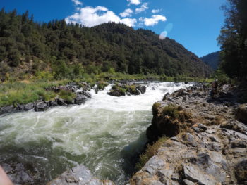
Rapids on the Rogue River, photo by Ron Smith
Recently as part of my personal effort to celebrate the 50th anniversary of the Wild & Scenic River Act, I arranged for my 13-year-old daughter and me to go on her first multi-day river trip. I chose as our destination the Rogue River and its 46-mile wild & scenic section. We would raft for three days, camp out for two nights, and take all our own equipment for camping.
Our guides were terrific. Our group of 18 was great and one other youngster was along, a boy in high school. We also were fortunate to have Bob Rafalovich as one of the guides. Bob has guided for 44 years on the Rogue. He founded the original outfitting company on the Rogue and he worked with government agencies to implement the Wild & Scenic Act on the Rogue. He was filled with stories and insights few others have.
We floated, we ran rapids, we hiked, we saw Zane Grey’s original 1939 cabin, we spent time at a true swimming hole up a side creek, we jumped off boats, swam in the river, saw black bears, shared stories with others, watched the Perseid meteor shower, learned about new flora and fauna, and Kira got to try rowing leading up to her taking the boat through a class 2 rapid.
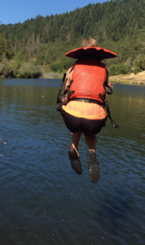
Never get tired of jumping, photo by Ron Smith
What did she learn? Here’s what she highlighted.
- Anything is possible but you have to be brave enough to try
- How to deal with initial failure and turn it into success with perseverance
- How to take risks and be more confident in taking them
- The value of patience
- The ability to be honest with each other and to laugh at ourselves
- To allow yourself to feel fear and let it pass through you
- It important to have a positive attitude in order to succeed
- Moving forward is the only option you have
- The most important things in life are personal relationships and a wanting to grow
- Liked not being tethered to her phone and free to really focus on where she was and what she was doing
- And there is only one person responsible for living the life you want; You.
The river provided me with a means to connect with my daughter, before, during and after the trip we took on it. The river gave us the means to create memories, stories, and experiences to help us grow as father-daughter and as individuals. We need to provide opportunities to our children and support the organizations that help with accessing those opportunities.
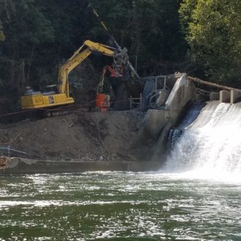
This guest blog is by Dr. Matt Baker, a researcher with University of Maryland Baltimore County, who is conducting monitoring research for the Bloede Dam removal project on Maryland’s Patapsco River. It was written before the initial demolition of Bloede Dam on September 11, 2018
This month, the Bloede Dam will be removed from the Lower Patapsco River near Ilchester, Maryland.
The restoration is a one-of-a-kind natural experiment that will help test how relatively inexpensive drones can help scientists like me understand the integrity of streams and rivers.
My collaborators include students and researchers from the University of Maryland Baltimore County, Maryland Geological Survey, Maryland Department of Natural Resources, National Oceanic and Atmospheric Administration and U.S. Geological Survey.
If our approach works, it will allow us to track sediment movement more completely and accurately than ever before, at a fraction of the expense.
What will change
Completed in 1907 and operational for 30 years, the Bloede Dam contained the first submerged hydroelectric plant in the U.S. At 26.5 feet high, it represents one of the largest dam removals on the Eastern Seaboard.
Why remove the dam? The state, federal agencies and nonprofit American Rivers hope to eliminate a derelict public safety hazard.
Taking out the dam will also complement restoration from previous dam removals upstream and expand connected habitat for fish and other aquatic creatures. The Patapsco once hosted major freshwater runs of shad, alewife and American eel, which were blocked by the dam. A fish ladder has proven ineffective at connecting upstream sections of the river with the downstream estuary and the Chesapeake Bay.
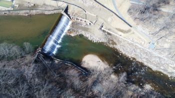
The Bloede Dam in March 2018. The obsolete fish ladder is in the foreground. Credit: Matthew Baker/UMBC
Despite a prominent role in early U.S. manufacturing, the Patapsco Valley has suffered its share of environmental challenges. Colonial shipping was forced to relocate to Baltimore after the original port at Elkridge Landing was choked by sediment from shipping ballast, river bank mining and upstream forest clearing. Once a 10-foot channel surrounded by a saltwater marsh, today the site is fresh and the channel less than two feet deep.
Periodic floods have also wreaked havoc in the narrow gorge, occasionally with catastrophic results. In the past few years, flash floods just upstream in Ellicott City have ruptured the sewer main that runs along the valley bottom and reorganized large quantities of sand, wood and rock in the downstream channel.
Today, the dam stores approximately 2.6 million cubic feet of stratified silt and sand less than eight miles from Chesapeake Bay tidewater. When the dam is removed, we want to know how this much sediment is going to move and how fast.
Why sediment movement?
Understanding sediment movement is critical for river management in every jurisdiction of the Chesapeake Bay watershed.
Sediment helps balance water flow to maintain channel shape and stable habitats for aquatic plants, invertebrates and fish. River sediment is necessary to help estuarine coastlines combat sea level rise. However, fine sediment can also be a pollutant in, or carry nutrients and heavy metals to, downstream estuaries.
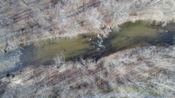
Aerial image of the Patapsco River channel showing gravel, cobble and sand deposits. Credit: Matthew Baker/UMBC
Although it’s easy to observe evidence of sediment erosion from riverbanks or hillsides, it’s often unclear where and how much of that sediment is redeposited and stored. Management of sediment storage, particularly behind dams, can be somewhat controversial.
After studying several other dam removals, we expect sediment trapped behind the dam to rapidly evacuate and redistribute downstream over a period of several years.
However, there’s still much we don’t know. Floods following intense storms can move huge quantities of sediment, altering the valley bottom in just hours. Will such storms redeposit sediment elsewhere in the gorge or the coastal floodplain, or deliver it to the bay?
New ways to track changes
It’s logistically difficult to accurately measure large and potentially rapid channel changes.
In a typical field survey, technicians measure water depth, flow, bottom substrate and other information at specific locations. Though stream channels can vary tremendously over space as well as through time, we scientists are rarely able to represent such variability in our measurements. Instead, we collect isolated snapshots in time. That leaves us with less understanding of dynamic sediment movement, devastation wrought by flood waves or the diversity of conditions necessary to support aquatic life.
Gauging stations located upstream and downstream of the dam measure water flow and estimate suspended material like fine silts and clays, but not coarser sands and gravels moving along the channel bottom. Surveys of 30 cross-sections distributed over eight miles provide information about how channel shape and composition vary as one crosses the channel, but relatively little about the thousands of feet in between each transect.
What’s more, after a major flood, scientists must conduct new cross-sectional surveys, taking up to a month in occasionally in risky conditions.
Our team is attempting to add to our measurements by deploying small, off-the-shelf drones that photograph the entire valley bottom. Repeat photographs before, during and after removal can help us track the location of a sediment plume as it moves downstream. They also allow new perspectives of the river.
3D view of a Patapsco River channel point cloud. Credit: Matthew Baker/UMBC
Relying solely on overlapping photos collected both before and after dam removal, we will create 3D computer models of the channel bottom and water depth – not just at the surveyed cross-sections, but every few inches along the channel. Although this technology works best in shallow water, our models should allow us to vastly improve estimates of both the amount and location of channel change as sediment moves downstream.
Scan of Patapsco River point cloud from Matthew Baker on Vimeo.
With the new approach, our team collects a photo set of all eight miles in just a few days, and further work occurs within a desktop computer. That means measurements can be repeated or made anew at any time using archived images.
Although we are certainly curious to see how this much sediment moves, we are especially interested in how well we can capture it. If it works, this technology will likely change the way scientists collect measurements and monitor rivers.
This blog was originally published in The Conversation on September 5, 2018. Link to original article: https://theconversation.com/drones-to-track-one-of-the-largest-dam-removals-on-the-eastern-seaboard-100071. This work is funded in part by American Rivers, National Oceanic and Atmospheric Administration, and U.S. Fish and Wildlife Service.
Dr. Baker is a professor of Geography and Environmental Systems at the University of Maryland Baltimore County.
Our aim was to breach the dam before Labor Day.
Rain. Rain. Rain. All year.
Nevermind. Too much rain. We’re working in a river. Water water everywhere. Project delayed.
No breach before September 6. More rain. There’s no way we can breach the dam before September 13. Let’s tell everyone.
Monday, September 10. We get a call from the contractor — hurricane coming. We’re breaching the dam tomorrow. What?? Everyone scrambles.
Blasting company drills holes in Bloede Dam in preparation for breach
Tuesday, September 11. I arrived at the site of Bloede Dam in the morning. The plan was to blast out a slice of the dam on the Howard County, MD, side of the Patapsco River. Holes have been drilled in the dam already. The contractor is filling the holes with explosive charges. They are moving quickly. They want to make this happen today.
The breach is expected to happen around 2pm. Okay, let’s gather the safety gear and head over to the other side of the river. (This is a crazy site in Patapsco Valley State Park where you have to leave the main part of the construction site and drive around for like 15 minutes to the other side, and then hike another 15 minutes up to the dam where the breach will happen.)
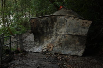
Used blast mats after the Bloede Dam breach
2pm arrives. They are working on placing the blast mats over the holes containing the explosives. It’s like a mat jigsaw puzzle. The blast mats will help contain the explosive force when it detonates. So those are pretty important. We’ll wait.
RAAAAAAAAAAAAAAAAIN. I am not kidding. I am hanging out in a picnic pavilion in the pouring rain. This will cause another delay. At least people will leave the park and stay out of the river, so there’s less of a safety concern.
The excitement and nervous energy is building in the picnic pavilion. A number of our closest project partners and a few regulators have gathered for the breach. Everyone asks if people are hearing a signal. No… just the train rolling along.
Around 4pm or so we hear three horn blasts. It is the three-minute warning. Everyone is standing. This is it! Then… a rumble like a roll of thunder sounds from upstream. I shout WOO HOO!! Cheers all around.
We get the “all clear” and start our trek up to the dam. We had to be a distance away from the dam for safety reasons. No one got to see the blast in person. Thank goodness for modern technology.
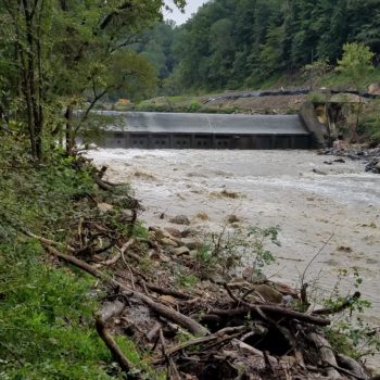
First glimpse of Bloede Dam post-breach
My first glimpse of the dam is surprisingly dry. The river is hiding. Where’s the breach? I can’t even see it yet.
The big hole comes into view. I have never been so excited to have put a giant hole in something before. I feel like a toddler run rampant with their first pair of scissors.
The feeling of triumph is prolific. There’s no turning back now. This dam is coming down. Finally.
Jessie with one of the project leaders from the National Oceanic and Atmospheric Administration, Mary Andrews
The next step will be to knock down the remaining structure with hydraulic hammers. You can check out the Maryland Department of Natural Resources Bloede Dam website to see that progress.
We are removing Bloede Dam so that no one else dies in the undercurrent at the base of the dam and so that migratory fish can be free to move upstream to live and spawn. This river will be healthier, and people will be able to paddle through this site, play in the flowing water, and find their zen in fishing. I cannot wait to see the Patapsco come back to life! Don’t worry… we’ll share it with you too.
Among the many heart-felt reasons people turn to the church, ones that resonate with me are to look for peace, to find a purpose, and to seek a connection to something that goes beyond our understanding and our lifetime. For me, the place I find these things is a mountain trout stream.
There is a feeling I get as I come into the forest and hear the river – a calmness from being where things are as they were meant to be. Seeing bright green moss on the rocks, hearing the laughing sounds of small waterfalls, sensing the strength of tall poplar trees watching over it all, and seeing the clean, clear water gathering and then flowing and then gathering again as it comes down from above and heads to where it can find its own level. If it is an old and natural place, you feel that it has always been that way with the rocks worn smooth over thousands of years and the soil rich and deep from generations of the forest falling there – and the river always alive and at the center of it.
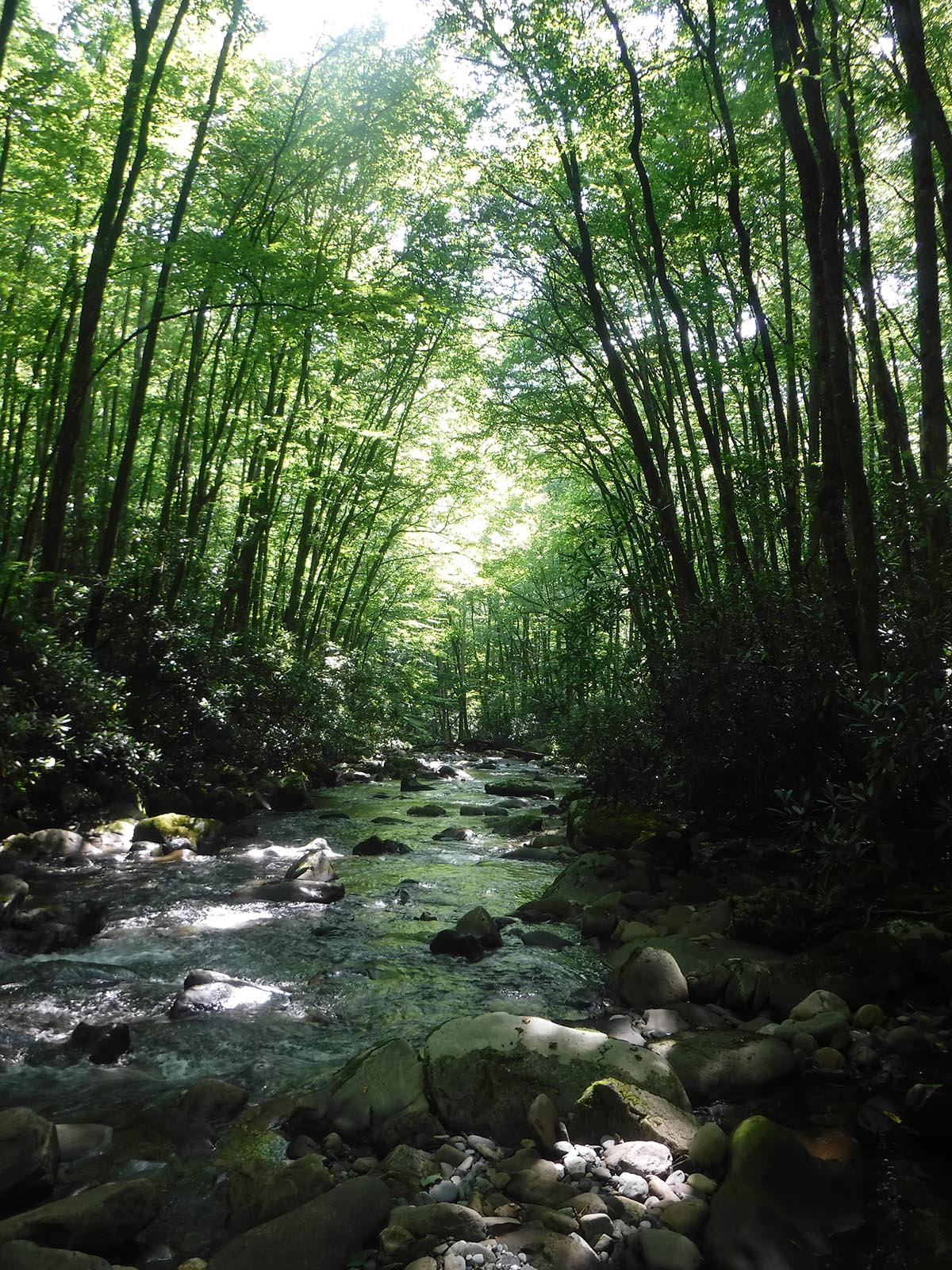
This past weekend was no exception. Hiking along a beautiful, small stream in Great Smoky Mountain National Park, the sounds and the coolness from the water made every step seem a little easier and the pack a little lighter. After several miles, we got to where it was time to pull out the wading shoes and the fly rod. This is where my church is. Looking upstream, the river comes down through the forest, bathed in filtered light from above. It is a cathedral in nature that happens in many places if you look for it. The alter is just a little farther ahead.
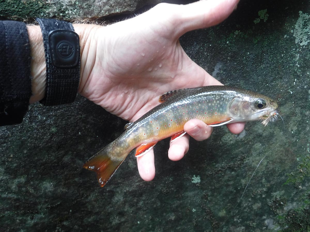
And the confirmation that this is someplace pure comes when a native Brook trout, whose ancestors have been here since the Ice Age, takes the fly. If the river was alive before, it’s even more so now as it cuts around rocks and through the pools. And then to hold this beautiful fish, with bright colors and sleek shape, before letting it go confirms that in this place, all is right with the world.
The good news is that this stream, its forests, and its trout are protected as part of the national park. Too often though, that is not the case. With less than one-half of one percent of our nation’s rivers protected by “Wild and Scenic River” designation, protecting more rivers is important work. It is the goal of our 5,000 Miles of Wild campaign, which you can read about here. What a wonderful calling to keep these natural cathedrals the way they were meant to be.
It’s time to talk trash again, or more specifically, plastic litter.
Last year, American Rivers teamed up with dedicated litter picker-upper and blogger, Erin Fitzgerald, on an initiative to – you guessed it – pick up litter. But this wasn’t an ordinary litter cleanup; it was a cleanup with a twist… Think scavenger hunt.
We had a lot of fun and received submissions from across the country. We raised awareness about the high prevalence of litter and sent a resounding message that we all have a shared responsibility to leave our wild places and waterways better than we found them.
Now is the time for another Litter for All Seasons scavenger hunt!
WHAT LITTER FOR ALL SEASONS IS AND HOW IT WORKS
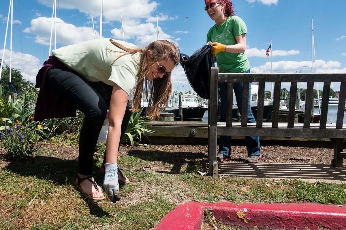
Volunteers pick up litter in Annapolis, MD. | Chesapeake Bay Program
A Litter for All Seasons is an invitation — an opportunity to clean up your favorite river, trail, park, riverbank or neighborhood and share your achievement. If you have kids, we encourage you to invite them along. It’s a great stewardship activity for all ages. You’ll be able to clean up your community, make a difference for rivers, and set an example for other stewards. And like any good scavenger hunt, there are prizes.
This month and throughout next year, we’ll announce a “Litter of the Season.” Then the hunt is on to find the challenge litter, take a picture of it, and post it to your personal Instagram or Twitter account with the hashtags #MakeAPactPackItOut and #RiverCleanup.
This fall, our Litter for All Seasons hunt, will be focused on plastic litter.
RULES & REMINDERS:
- Discard of the litter responsibly (recycle it or put it in the trash).
- Feel free to keep the hunt going – you can pick up and tag as much litter as you find, but you’ll only get one entry per person for each season.
- Your picture(s) will populate on American Rivers’ Virtual Landfill and Erin’s online gallery, Make a Pact, Pack It Out.
- Grow the scavenger hunt – share this blog post and your plastic litter photos with your friends, family and co-workers to encourage them to join you (maybe a little friendly competition to see who finds the most of plastic litter). Your friends, family and co-workers will be more likely to join in if they see that you are.
THIS SEASON’S LITTER CHALLENGE
Your challenge is to find discarded plastic of any kind (bottles, straws, bags, cutlery, packaging, caps/lids, etc.). Once you find plastic litter, take a picture of it and post it to your personal Instagram or Twitter account with the hashtags #MakeAPactPackItOut and #RiverCleanup (make sure your accounts are public!).
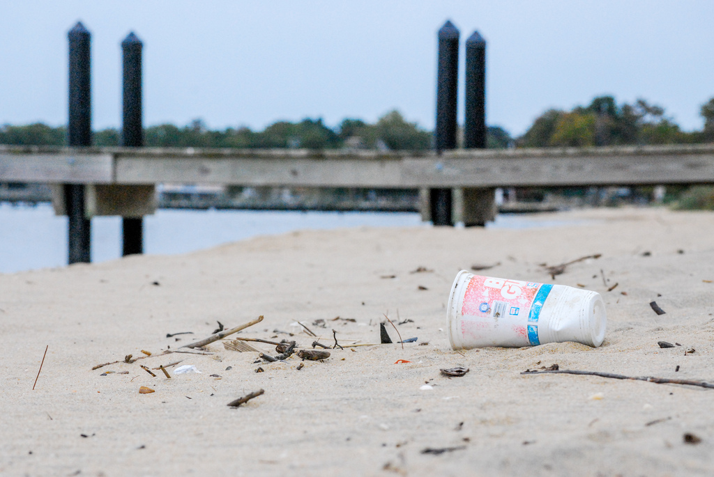
A plastic cup sits on a beach. | Chesapeake Bay Program
Plastic is one of the most heavily littered items and can take hundreds of years or longer to break down — or not at all. Plastic breaks down into smaller pieces called microplastics.
Alternatives exist for most single-use plastics – we encourage you to adopt a mindset of reusing, refilling and repurposing to reduce your plastic footprint. From the garbage patch in the Pacific Ocean to plastic water bottles and straws on a roadside, plastic litter surrounds us and threatens our pets, wildlife and waterways.
PRIZES: Three (3) winners will be chosen at random and matched with a prize that is the perfect complement for outdoor adventures. One (1) winner will receive an American Rivers branded Klean Kanteen reusable insulated bottle and two (2) winners will receive both a Chaco® Fit for Adventure notebook (8×8”) and a LOKSAK® reusable waterproof bag (8×7”).
TIMING
This season’s scavenger hunt kicks off Tuesday, September 18 and ends on Monday, October 1. Your picture(s) must be uploaded to social media account(s) with the hashtags #MakeAPactPackItOut and #RiverCleanup by 11:59 pm PST on October 1 to be eligible to win (see complete rules).
ANTICIPATED SCAVENGER HUNT SEASONS
Don’t miss a season – make sure to check American Rivers’ The Current blog and Adventures in Thumbholes’ blog for updates on timing. Scavenger hunts will also be announced on social media, so make sure you’re connected to @AmericanRivers and @Thumbholes on Instagram, Twitter, and Facebook (@AdventuresInThumbholes for Facebook).
- September 2018
- March 2019
- July 2019
- September 2019
PRIZES
Each Litter Season will have a different treasure (prize) up for grabs. Prizes will be in the spirit of sustainability and stewardship. At the conclusion of each scavenger hunt, a winner will be selected at random from all entries.
As environmental stewards, we know picking up and packing out litter not only keeps our public spaces looking great, but all of our wild places. When litter is left on our lands, rain and floodwater can carry it into storm drains and then quickly into our creeks, rivers and even oceans.
We look forward to seeing your submissions, as they represent stories of stewardship and care behind every piece of litter picked up. While traditional scavenger hunts focus on a treasure – here the treasure is knowing you left the environment better than you found it.
Author: Erin Fitzgerald is a trail runner from Portland, Oregon. Her blog, Adventures in Thumbholes, has two initiatives (Small Change and Make a Pact, Pack It Out) that focus on stewardship and giving back to the communities where we race and adventure. Erin’s passion for preserving wild places has earned her the reputation of a litter-picker-upper, which she happily embraces.
This blog is a guest column by Donna Stevens, Director of the Upper Gila Watershed Alliance, and was originally published in Desert Exposure magazine.
We’re all a little bit in love with rivers. Like a teenage crush, we’re first dazzled by their beauty. Soon we crave how they make us feel when we’re near them, like the world is new and everything is possible. We hear their songs, and fall deeper. We realize that rivers feed us, our bodies and our spirits. As we play and fish in them, our joy mingles with their waters.
When we grow up, we understand that real love means not just taking what we want, but also giving back. We discover that the river needs something from us, and because we’re in love, we want to give it, protect it from harm.
In the early days of this country, there was an expectation that the land and water would always provide for us. To develop and grow, we dammed all the big rivers, and then began to exploit the small ones.
In the 1960s, river lovers began to acknowledge that our nation was just taking from rivers, and not taking care. They saw wild rivers disappearing and determined to give back to them in a permanent, protective way. Secretary of the Interior Stewart Udall (Senator Tom Udall’s father) joined the cause. Together, they persuaded Congress to protect the rivers we love, and in October 1968, President Lyndon Johnson signed into law the Wild and Scenic Rivers Act.
As part of this act, eight rivers, including the Rio Grande in northern New Mexico, with its tributary, the Red River, were immediately designated as Wild and Scenic Rivers. Since then, the East Fork of the Jemez River, the Pecos, and Rio Chama in New Mexico have also been protected as Wild and Scenic. Residents enjoy these rivers, and local economies continue to prosper as visitors flock to them, spending their tourist dollars.
Across the nation, more than 12,700 miles of rivers have received Wild and Scenic River status. Sounds impressive, but that number represents less than one percent of the total river miles in the country. Now is not the time to rest.
In the Land of Enchantment, there are no protected rivers in the southern part of the state, and not for lack of deserving river segments. In this arid landscape, rivers and streams are the lifeblood of the land.
The Gila River, with its headwaters in the Gila Wilderness – the nation’s first designated wilderness area – is eminently qualified for Wild and Scenic status. The last free-flowing river in the state, the Gila is unmatched for activities like hunting, hiking, fishing, and just enjoying the outdoors. Miles downstream of the Gila’s three Forks – East, West, and Middle – is the Gila Middle Box, a tight canyon of towering pink cliffs “boxing in” the river, with flood debris wedged twenty feet overhead, spanning the river.
There are many such wild river segments in the Gila National Forest: the Lower San Francisco, with its soothing hot springs; McKnight Canyon, where the East Fork of the Mimbres is lush and shady; Whitewater Creek above the Catwalk; Black Creek, arising from high headwaters at Reeds Peak in the Aldo Leopold Wilderness. There’s an intriguing litany of history in these names: Indian, Mogollon, Diamond, Sapillo, Turkey, Iron, Gilita, and Little Creeks – not to mention Holden Prong. These streams feed our imaginations and provide a home to native fish, resident plants, and wildlife.
During the 14th Annual Gila River Festival, participants can experience firsthand some of these cool river stretches, and see for themselves why they deserve protection.
Because we love these rivers, we want to keep them as they’ve always been. This won’t just happen on its own. Protection, like love, is an active process. Wild and Scenic River designation means that we keep the river as it is now. Proposed projects that would degrade the river – water quality, wildlife habitat, and wild characteristics – would not be allowed.
The Wild and Scenic Rivers Act has three designation categories: wild rivers are rivers, or sections of rivers, that are free-flowing and usually reached by a trail. Scenic rivers are also free-flowing, but accessible by roads in some places. Recreational rivers have easy motorized access and often some development along their shores.
Demands on our rivers will only become greater as the human population grows. Precipitation and water levels may decrease, and new threats are likely to materialize. Just as we safeguard our beloved children and grandchildren against peril, we need to protect our rivers and streams. It’s time to move beyond a mere crush, send a valentine to our rivers, declare our undying love, and ensure that these rivers get the protection they need and deserve, so future generations can fall in love with them, too.
The Gila River Festival features field trips to some of these river segments. For more information, visit www.gilariverfestival.org
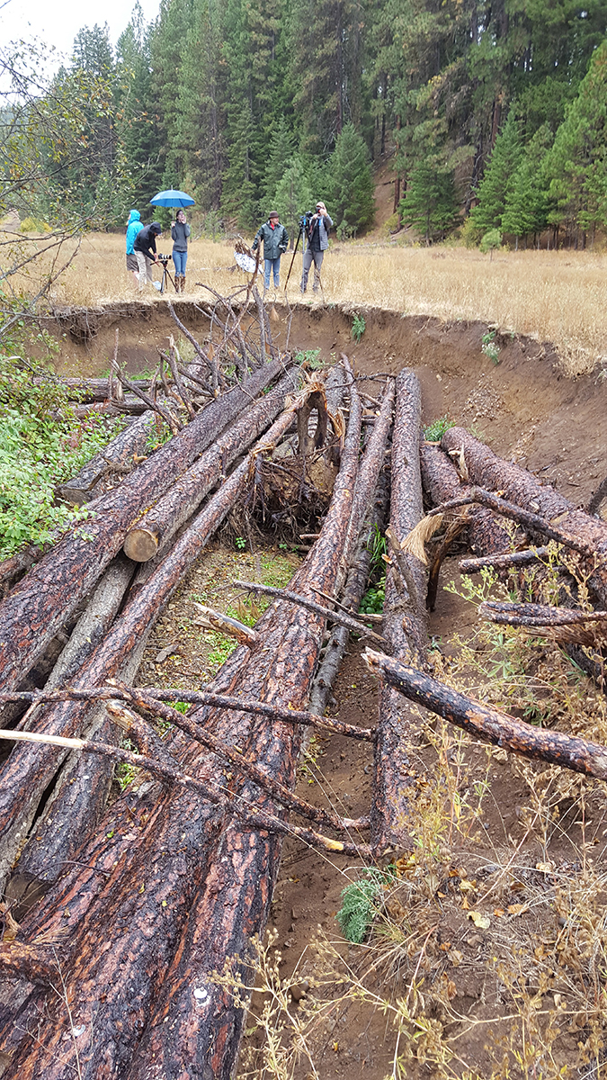
On a brisk November afternoon in the Central Cascades, a group of restoration scientists and conservationists stood along the banks of Jungle Creek. Peering down at the passing water, we watched the creek flow silently and uninterrupted over a smooth stone streambed. Even standing next to the creek we were far from the water; the streambed was many feet below us. This particular reach of Jungle Creek was suspiciously straight and without clutter from debris, large rocks, or even gravel. It was as if a bulldozer had carefully plowed along the streambed creating a deep channel, not unlike a canal. This was not a healthy stream, and we had gathered to discuss our efforts to fix it.
Nestled among the Cascades, the Teanaway Community Forest was established in 2013 to protect 50,000 acres of state public land and over 400 miles of free-flowing streams. The Teanaway is Washington State’s first community forest, collaboratively managed by the State and a community-based advisory committee that includes Yakama Indian Nation, residents, business owners, local governments and conservation groups. The Teanaway Community Forest is a successful experiment in multiple-use land management that demonstrates how protecting healthy ecosystems and supporting working landscapes can go hand-in-hand. The Yakima Basin Integrated Plan Workgroup and its partners in the conservation community championed the Teanaway Community Forest acquisition to the state legislature and remain involved in this unique joint management effort, as protection of the Teanaway basin is the first major step toward restoring headwater habitat within the Yakima Basin.
The Teanaway is home to populations of wolf, elk and spotted owl, and contains over 400 miles of streams that feed the Teanaway River and the headwaters of the Yakima River Basin. Until the mid-20th century, the Teanaway valley was used for timber harvest and as open grazing lands. Historically, streams provided a means to transport harvested timber downstream, and had to be straightened and kept clear of natural wood debris to do so. As a result, complex fish habitat was removed, and streambeds eroded downward over time. Despite being protected today, many streams in the Teanaway valley remain in degraded conditions. This is a problem, because the Teanaway’s feeder streams provide critical habitat for endangered bull trout and mid-Columbia basin steelhead, as well as salmon. In their current state, these streams are unlikely to support the recovery of endangered fish, especially as the impacts of climate change intensify in the coming decades.
Returning Large Woody Debris to Streams Can Restore Ecosystem Functions
Restoring a river is less a result of work that people do, and more a result of work that a river can do on its own when allowed. Rivers, streams and creeks are pretty clever systems, underpinned by natural processes that maintain everything from the quality of water to the character of a riverbank. Whether removing a dam, setting back a levee, or returning wood to a stream, river restoration is the act of returning natural processes that a river needs to passively restore itself.
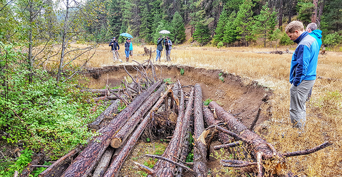
Restoration using large wood on Indian Creek completed in 2015. Sediment is already beginning to re-aggrade streambeds on treated reaches, enhancing water storage and restoring fish habitat overtime.
In eastern Washington, Yakama Nation Fisheries has pioneered an approach to return large wood debris to degraded streams and floodplains and, in doing so, restore natural river processes. Wood debris naturally accumulates in forested rivers and is especially important in high-elevation cold-water streams such as the Teanaway River. Fallen trees and woody debris create logjams that produce deep pools, provide shade, and enhance roughness and sediment storage, together these factors maintain base-flow and cold-water habitat for fish.
Restore Habitat Today to Enable Species to Adapt to Climate Pressures Tomorrow
Degradation from past land use has stymied the Teanaway’s capacity to support the recovery of endangered fish, whose recovery is further jeopardized by warmer stream temperatures and lower summer flow levels driven by climate change. Fortunately, we can undertake restorative actions today to begin addressing these pressures, and support the ability of some species to adapt to the impacts of climate change as they progress.
Yakama Nation Fisheries’ wood restoration efforts aims to restore basic hydrologic and ecosystem functions to streams, naturally restoring instream and floodplain habitat overtime. As Scott Nicolai, Yakama Nation Fisheries’ project manager describes it; engineered log jams are not an attempt to control a stream, but instead act as a simple “suggestion to the stream” by reintroducing wood structures that encourage the system to retake natural form and functions. Restoration outcomes compound over many years as streams retain more sediment and streambeds rebuild, eventually reconnecting with side-channels and floodplains. Yakama Nation’s proven restoration methods and the compelling story of conserving the Teanaway Community Forest were central to securing a new grant to continue this work.
Wildlife Conservation Society Supports These Expanded Stream Restoration Projects
These structures also provide shade and create deep pools, critical habitat for endangered steelhead and bull trout in the Yakima River Basin.
In December 2016, American Rivers, Trout Unlimited and The Wilderness Society’s joint restoration proposal was competitively selected for funding by the Wildlife Conservation Society’s Climate Adaptation Fund. The Climate Adaptation Fund awards grants to conservation organizations for applied, on-the-ground projects that implement conservation actions to advance climate adaptation at a landscape scale. Awarded funds directly supported restoration of 8.5 miles of tributary habitat and 150 acres of floodplain on eight creeks, implemented by Yakama Nation Fisheries. American Rivers, Trout Unlimited, and The Wilderness Society have been carrying out a strategy to showcase woody debris restoration techniques and outcomes, and have been engaging with local and regional stakeholders to further grow public support for conservation and restoration through volunteerism in the Teanaway Community Forest.
While the restoration projects are taking two years to complete, the outcomes will build upon themselves for decades. Cold-water stream habitat will be re-established and streams and floodplains will be reconnected; critical steps to recovery of endangered salmon, steelhead, and bull trout. As a result, the Teanaway Community Forest and larger Yakima River Basin will be better prepared to adapt to the impacts of climate change in the coming century. These projects will provide valuable data to inform restoration efforts elsewhere in the region, and serve as a powerful example of how conservation partnerships can leverage investment to benefit communities and ecosystems.
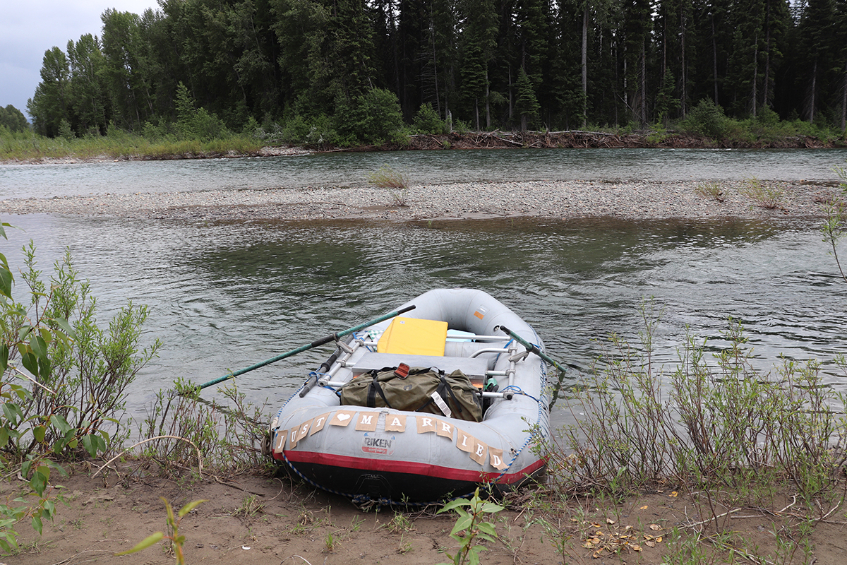
No one ever tells you how fast it all goes by – the ceremony, photos, reception, eating, dancing, crying, laughing. The act of getting married will forever be a blur in my memory. All of it except the river.
My husband, Dan, and I were married on June 30 on the North Fork of the Flathead River in northwest Montana. The North Fork was designated a Wild and Scenic River in 1976. Its headwaters begin in Canada and flow south to its confluence with the Middle Fork Flathead, forming the western boundary of Glacier National Park. There are many reasons we chose this place to declare our lifelong commitment to one another. After all, our love for one another grew out of our love for rivers.
I grew up in Maryland, on the eastern shore of the Chesapeake Bay, where rivers are hard to escape. I worked in river conservation in Maryland for a few years after graduating college, however, it wasn’t until moving to Montana in 2011 that I truly developed my current love affair with rivers. The experience of multi-day river trips was something Dan first shared with me, and I quickly became obsessed. Almost every chance we have had together over the years, whether an evening float after work, wade fishing while walking the dogs, or multi-day floats over holiday weekends, we have been pulled to rivers.
Because of this relationship, it was no surprise that we would choose to get married on a river. And not any river, but a river forever protected as wild and scenic.
In the days leading up to the wedding, the weather was predicted to be fair at best – 60 degrees with a 60 percent chance of rain. But we told everyone “river or bust,” and on Saturday morning we loaded up our closest family and friends into rafts and launched on the river. We had planned to float an 11-mile section of river from just south of the Canadian border down to the small off-the-grid settlement of Polebridge. We had found a spot on the Glacier National Park side of the river to hold the ceremony with the towering Livingston mountain range serving as our backdrop and the sound of the river as our background music.
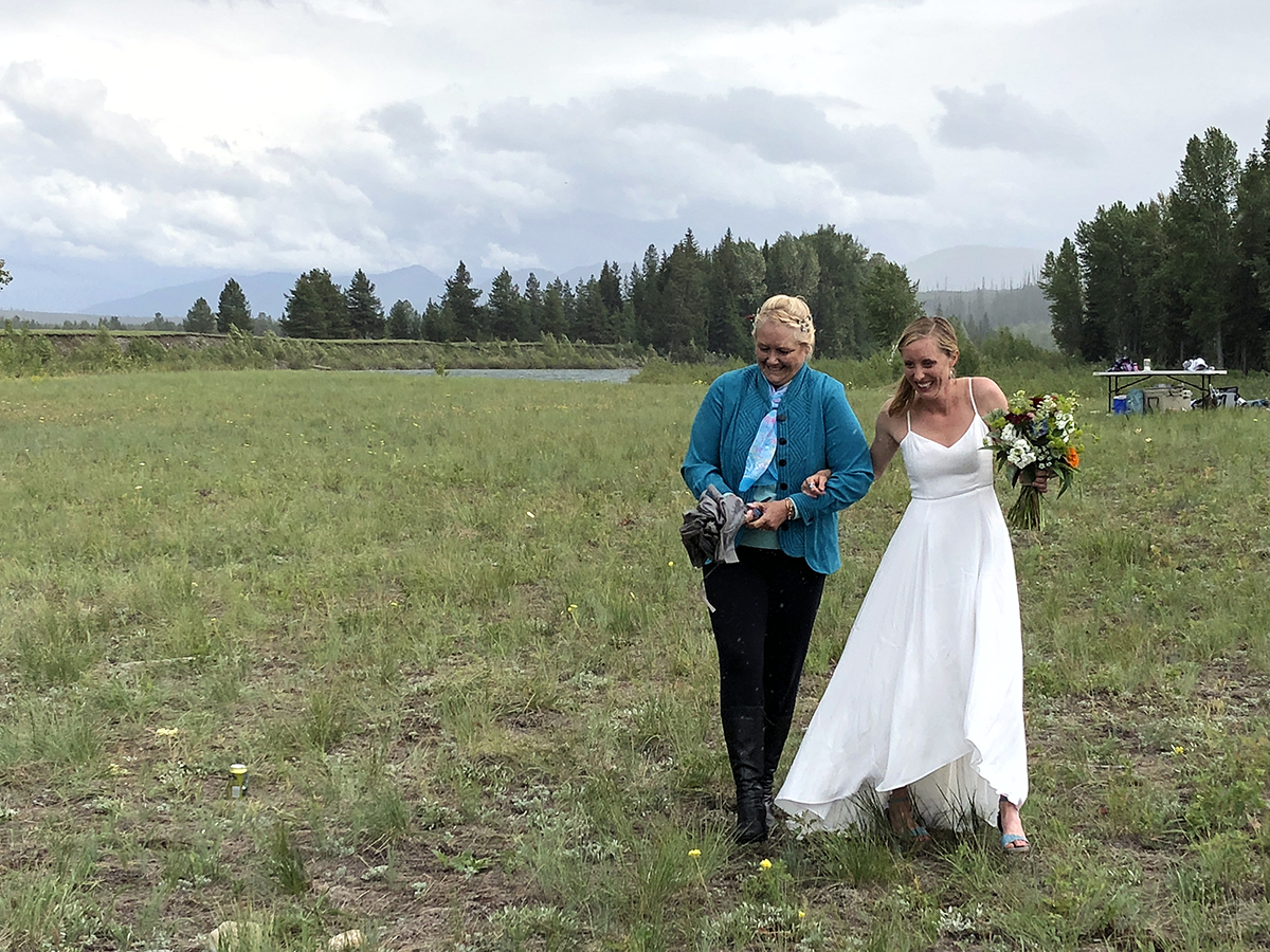 As my mother escorted me across a meadow towards our friends, family and my husband-to-be, an osprey hovered overhead, circling us as we walked. I still think it might have been the reincarnated spirit of my father, watching the event and guiding me with my mother.
I’ve been struggling with how to truly capture the emotion of that day, as it ran the gamut. One of our friends, Kit Fischer, author of Paddling Montana, gave a beautiful reading during our ceremony; a portion of which I feel compelled to share as it so eloquently compares rivers and marriage.
“Wild and Scenic River designation, much like the vows of marriage, protects rivers from future development and ensures it can stand the test of time. But like any free-flowing river and any marriage, there will be floods and there will be droughts. There will be hot streaks and howling at the moon. But through it all – they fill our lives with love, laughter and friends. Love, like a river, will cut a new path when it meets an obstacle. And your love will be no exception.”
The rain was on and off for the duration of our ceremony, but as we started our vows the sun broke through the clouds and the umbrellas were closed. We concluded with a champagne toast and some of our favorite songs, loaded everyone back onto the rafts and floated to the take out.
Dinner and dancing went by in a flash and before I knew it, we were back at our cabin, completely exhausted. The only word I can use to describe the feelings of that day is gratitude. When I shared my vision of a dream wedding to Dan and my friends, no one batted an eye. They made it happen for me. They organized rafts, prepared food, loaded supplies, ran shuttles and traveled from far and wide to show their love and support. Even now when I think back to that day, I am still overwhelmed with gratitude. I feel like the luckiest woman in the world, that I have so many people in my life who care for me and Dan, that care for us so much they made our dream come true without question or hesitation.
Thanks to the Wild and Scenic designation of the North Fork Flathead (along with the Middle and South Forks of the Flathead) in 1976, it will forever be protected as free flowing and clean. This designation allowed for our public access and celebration of one of the most important events of our lives. As a Montanan, it’s still shocking to me that only five of the rivers in our state have this permanent protection status: the three forks of the Flathead River, 150 miles of the Upper Missouri River and most recently East Rosebud Creek in the Absaroka-Beartooth Wilderness. But hopefully there are more protected rivers on the way. A coalition I work with called Montanans for Healthy Rivers is spearheading the development of new legislation that would protect close to 50 new rivers and streams in the state as Wild and Scenic.
 In the end, it all comes back to rivers. Rivers connect us; they bring us together and take us places where we couldn’t be otherwise. Although Dan and I are outdoors people and find ourselves in beautiful places all over the world, the North Fork Flathead will forever hold an especially important meaning to us. It is a place that will remind me of how lucky I am to have a husband and people in my life who love me, support me and want to be apart of making my dreams come true. What more could anyone ever want?
Do you have a river story to share? Please visit 5000miles.org today and help us protect more of our most cherished rivers by telling your story.
Dams! Be they small ones that clog tributary streams or vast hydropower developments that impact hundreds of river miles, dams profoundly impact rivers by altering natural flows, impairing clean water, harming wildlife, and limiting river recreation.
This summer American Rivers and our partners celebrated two great successes for rivers in the Southeast involving hydropower dams. Benefits to the Broad River in South Carolina and the Coosa River in Alabama were achieved through the federal relicensing process for hydropower dams. Yet, how those victories came about differs greatly.
Federal licenses for dams last a generation or longer
The relicensing process for non-federal hydropower dams, those operated by electric utilities, municipalities or private entities, provides a once in a generation opportunity to improve the way these dams operate and undo environmental damages. Conditions for new operating licenses can be one of the most effective tools for improving the health of rivers that have been impacted by hydropower dams.
Non-federal hydropower dam operators are required to get licenses that balance hydroelectric generation with environmental protections such as improving downstream river flows, safely passing migratory fish around (or over) dams, enhancing dissolved oxygen levels in water discharges, and creating new recreational opportunities. The licenses are issued by the Federal Energy Regulatory Commission (Commission) and last from 30 to 50 years! Relicensing dams when their current licenses are set to expire provides opportunities to improve for decades the way these dams operate to protect, restore and enhance rivers.
Perhaps in no other region is this more important than in the Southeast where new licenses have been required for a myriad of large dams built primarily from the early 1900s to the 1950s.
Reaching agreement for improving the Broad River
One highlight of the settlement is a nearly three-fold increase in downstream flow requirements during spring months on the Broad River. | Ron Ahle
Our first reason for celebration is the signing of a comprehensive relicensing settlement agreement for the Parr Shoals Hydropower Project on the Broad River upstream of Columbia. Operated by South Carolina Electric and Gas Company, flows passing through the dam contribute virtually all water for 26 miles of the Broad River and most of the water for 50 miles of the Congaree River. The dam also creates Parr and Monticello Reservoirs, totaling 11,100 acres. The settlement agreement provides a set of consolidated recommendations for new license conditions to the Commission. Signatories include the power company, American Rivers, Congaree Riverkeeper, US Fish and Wildlife Service, National Marine Fisheries Service, SC Department of Natural Resources and other stakeholders.
Highlights of the settlement include:
- a nearly three-fold increase in downstream flow requirements during spring months from the current 800 cubic feet per second to 2,300 cubic feet per second
- downstream flow requirements of 1,000 cubic feet per second during the remainder of the year, more than six times more water than currently required
- fish passage for American shad
- extensive investment in new equipment by the power company to reduce unnatural downstream flow fluctuations and meet state dissolved oxygen standards in flow releases
- protection of over 1,000 acres of riverside lands
- improved recreation facilities for boaters, anglers and campers
The settlement also establishes a mitigation fund for environmental enhancements to offset impacts to fish and wildlife and recreation caused by Parr Reservoir water level fluctuations. Tied to the amount of generation, the fund would be valued at approximately $4 million if a 40-year license were issued.
If accepted by the Commission, which usually adopts recommended terms of comprehensive settlement agreements, the above improvements would start after a new license is issued. The current project license expires in 2020.
The Parr Shoals relicensing process is a testament to the collaborative approach adopted by South Carolina Electric and Gas Company so that a comprehensive settlement agreement could be reached with local stakeholders that balances environmental benefits with power generation.
Winning in Court to Protect the Coosa River
The construction and operation of the Coosa River dams resulted in one of the largest mass extinctions of the 20th Century. | Coosa Riverkeeper
Our Alabama success followed a much different path. The Coosa Hydroelectric Project consists of seven dams affecting 225 miles of the Coosa River. The construction and operation of these dams resulted in one of the largest mass extinctions of the 20th Century with over 30 aquatic species being lost. Once one of the most biodiverse rivers in North America, additional species of freshwater mussels, snails and fish continue to be threatened by these dams. Several of these species are either listed or are being considered for listing under the federal Endangered Species Act.
The Coosa relicensing was derailed by distrust and non-cooperation. Rather than take the collaborative approach used by South Carolina Electric and Gas Company, Alabama Power Company – which operates the dams – ignored issues raised by stakeholders and didn’t complete adequate studies for a new license.
American Rivers and our conservation partners Alabama Rivers Alliance and Southern Environmental Law Center were actively engaged in the relicensing of these seven dams from the initial meetings through the new license being issued. Throughout the process we recommended studies to assess impacts of the dams, reviewed technical reports and issued written comments which consistently called for sound scientific information, thorough assessment of impacts, rare species protection, healthy river flows, and improved dissolved oxygen levels. Our recommendations were ignored first by Alabama Power, then by US Fish and Wildlife Service and finally by the Commission.
The Coosa was once one of the most biodiverse rivers in North America.View of the Coosa River in Wetumpka, Alabama. | Southern Environmental Law Center
Alabama Power submitted a license application to the Commission that failed to protect the region’s rich biodiversity. Analysis showed that the company’s proposed operations could harm up to 100% of certain species protected under the Endangered Species Act. The license application also failed to include measures for raising dissolved oxygen levels to meet state standards and would only minimally increase flows in the Weiss Bypass, a 20-mile river reach that harbors endangered species from which most all flow is diverted by the hydropower dams.
The Fish and Wildlife Service did no better. The Service kotowed to Alabama Power and issued a biological opinion that ignored the impacts to species protected under the Endangered Species Act and supported the power company’s flawed license application.
The Federal Energy Regulatory Commission also failed to live up to its regulatory responsibilities and issued a 30-year license to Alabama Power that by and large adopted the harmful terms favored by the power company.
So how is this something worth celebrating?
Instead of folding, the conservation groups acted. We filed a lawsuit in federal court against the Commission and Fish and Wildlife Service for violations of the Endangered Species Act, Federal Hydropower Act, and National Environmental Policy Act.
Weiss Reservoir behind Weiss Hydropower Dam. | Pamela [Flickr CC]
A most effective tool for improving river health
Be it through settlement agreements or legal challenges, these examples demonstrate how relicensing can be one of the most effective tools for improving the health of large rivers damaged by hydropower dams. Recognizing this, American Rivers has been the national leader for reforming hydropower dam operations since the 1990s. These new licenses will help protect endangered species, restore river flows, improve oxygen levels and enhance recreation opportunities after more than 80 years of impacts to rivers in South Carolina and Alabama. These successes which came after years of hard work by American Rivers and our partners are surely worth celebrating!