Join us for Episode 3 of Ripple Effects, a look into how Eagle County, Colorado connects with and depends upon their local rivers including the Eagle, Upper Colorado and Roaring Fork.
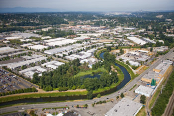
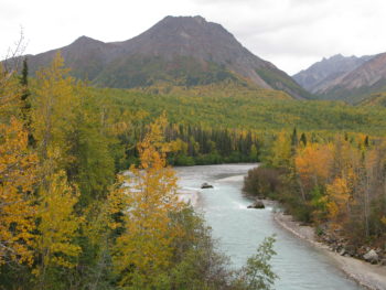
Eagle County is known for its amazing landscape and iconic rivers that make up the two prominent valleys in the County – the Eagle Valley and the Roaring Fork Valley. Eagle County is Home to the Gore Range, thousands of acres of pastoral farm and ranch land, a popular reach of the Upper Colorado River, part of the Roaring Fork and the entirety of the Eagle River. Residents and tourists alike are drawn to the amazing landscapes of Eagle County.
Local residents and the economy of Eagle County is deeply tied to its rivers. Historically, water was needed in the valley to support the county’s economic engine – agriculture. Today, Eagle County’s rivers not only support farming and ranching but also a vibrant recreation economy in both the summer and the winter. River based recreation including paddling, fishing, running, hiking or picnicking alongside local rivers is a hot commodity in the summer. In the wintertime, Eagle County’s rivers supply water needed for snowmaking in the many ski resorts across the County.
Earlier this year, I chatted with Eagle County Commissioner Kathy Chandler-Henry and Diane Mauriello who is the Director of Eagle County Open Space. Both agreed that rivers are vitally important to the communities within Eagle County – in both the Eagle and Roaring Fork Valleys. Here is what Commissioner Chandler-Henry had to say about the importance of rivers to her community:
“The rivers in Eagle County are the lifeblood of our communities. They sustain our wildlife, irrigate our crops, and provide water for summer play and for snowmaking in the winter. Our rivers define us.”
It’s clear from Commissioner Chandley-Henry, that like many other river towns and communities in Colorado, residents of Eagle County are both dependent on and committed to their rivers. The local communities have protected important riverside lands, restored reaches of rivers and streams, conserved pastoral working landscapes and provided recreational access to the different bodies of water throughout the county.
Eagle County residents understand the importance of a healthy, flowing river for their community. Rivers in Eagle County support the region’s way of life including summer and winter recreation, clean drinking water, and the County’s essential agricultural heritage.
The rivers and streams that flow through Eagle County are part of the region’s iconic landscape. It’s clear that residents and decision makers in Eagle County are committed to protecting and preserving these resources that are vital for their way of life. Join us for Episode 3 of Ripple Effects to hear more about the thriving Eagle County and the many ways residents and tourists alike benefit from their healthy, flowing rivers.
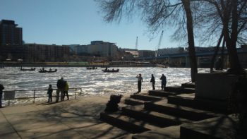
The winter we all just experienced was, in some ways, downright epic. The ski season at a number of resorts across the state is still in full swing, yet the kickoff to the rafting season has actually been a bit halting – since in some rivers there is just too much water to be safe. The Animas and the Rio Grande, for instance, have temporarily halted rafting and fishing operations from providing guide services on certain stretches until the peak flows have passed.
Snow Water Equivalent maps, like this one from the NRCS, are reporting totals in the hundreds, or thousands, or even tens of thousands of percent above normal for every day that goes by. Lake Powell has risen over 25 feet since mid-April (potentially gaining up to 50 feet before all is said and done,) and there is still much snow in the upper elevations (above about 11,000ft.)
And, for the first time in nearly 20 years, there are no declared drought declarations anywhere in Colorado.
So we’re good, right? No need to worry?
Not so fast.
One wet year doesn’t make up for the array of problems that residents across Colorado, and more urgently across the entirety of the seven state Colorado River Basin, have been dealing with for nearly two decades. Diligence and planning are still essential for future sustainability in the Southwest – we were just given an opportunity to catch our breath for a hot minute.
Back to Lake Powell – in the best-case scenario, the reservoir may only fill to about 54% of its capacity after this year’s runoff is all said and done. Granted, it started the year around 40%, so this is a big improvement, but still not enough relieve concern of a serious deficit for years to come. Then on to Lake Mead, where the lake levels are only projected to remain fairly steady, continuing the threat of a looming shortage in Arizona. In short, just because we had one solid year of snowpack (which supplies about 80% of the water in the Colorado River basin,) that doesn’t mean that the overall imbalance in the system has been solved.
The Lower Basin states use more water than the Upper Basin states can reliably supply. This is called the Structural Deficit, and is caused by a number of factors around how the Colorado River and its tributaries are legally bound to manage water for the 37 million people and $1.4 trillion economy that depends on it. So what do we do about this situation? In short – everything is better with a plan.
Ultimately, what we are talking about here is reducing risk – risk to the river, risk to our economy and lifestyle, risk to our society. Taking these actions now reduces that risk.
First and foremost, the Colorado’s Water Plan, which provides a roadmap to putting Colorado on better footing with how we encourage water conservation in cities and towns across the state, how we help agricultural users grow more crops with less water, and how we work together to keep more water in rivers and provide resilient ecological health for streams across the state. Now, the time has come to fully fund the implementation of the Plan to ensure a thriving Colorado for years ahead.
Next, we have signed Drought Contingency Plans, which provide guidance for how different states, and users within those states, manage their water supply obligations over the coming years. Are they perfect? Are they silver bullets? Absolutely not, but they have provided a framework for collaboration and forged relationships that will become even more urgent as the states begin negotiating even more critical policies for how the river will be managed in coming years. The real work is just over the horizon.
Lastly, the concept of Demand Management, which is a mechanism by which water users, like ranches for instance, can reduce their use and let more water flow by their head gates, while earning compensation for doing so without completely losing their long-term access to water. Quite simply, this program can help keep more water in rivers for fish, wildlife, and recreation across the Colorado River and its tributaries. Demand Management is one strategy being considered and tested to deal with a growing population and an increasingly urgent reduction of our basic water supply due to climate change.
In short, there are solutions to the array of challenges that are facing the Colorado River, and the people and economies who depend upon it. What it means, though, is that people have to do the hard work of setting aside serious differences, contemplate real solutions, and be considerate of the various interest groups who rely on, and love, the Colorado River.
There are no simple answers to a century of complex problems – and one good year of deep snow certainly is not a get out of jail free card in this current situation. Only with planning and concerted effort will we forge a path to better sustainability for our rivers, and the people who depend upon them, across the west.
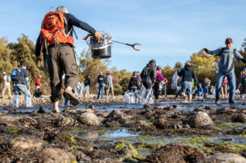
The Salt River: A place to go salt water tubing, to see wild horses roam and bald eagles fly… and where volunteers frequently gather to tackle a massive trash problem.
Since March 2015, Natural Restorations, co-founded by Nicole and Justin Corey, has organized 49 cleanups removing 366 tons of trash from Arizona rivers, outdoor recreation and wilderness areas. That is the equivalent weight of 246 compact cars.
Why is there so much trash? Decades of trash has piled up for years along the Salt River which winds its way through the Tonto National Forest and Phoenix until it dumps into the Gila River, recently named the #1 Most Endangered River of 2019.
3rd Annual Green Friday Cleanup, Lower Salt River | Robert Coonrod
Only an hour drive from Phoenix, AZ, the lower Salt River rapids and National Forest are a hot spot for those seeking easy access to nature. With 365 days of sunshine, dry weather and accessible tube rentals and shuttle services, the Salt River never gets a day off.
Tubing on the Salt River is an “Arizona tradition” with floats lasting between 2-6 hours, primarily from May to Labor Day weekend. With temperatures reaching the triple digits, floaters cover their inner tubes with sheets and blankets to prevent burning their skin against the hot plastic, but this has created other problems.
These sheets and blankets along with water bottles, clothes and fishing line contribute a significant amount of trash on the river and threaten the surrounding wildlife. In one instance, a wild horse had to be rescued after becoming tangled in a fishing line left behind.
Natural Restorations started removing decades old trash and has recently tackling new litter left on the Salt River, Gila River, Santa Cruz River and Fossil Creek. Their Green Friday Lower Salt River Cleanup at Phon D Sutton cleanup in Nov. 2018 recruited 346 volunteers with 109 who were under 18.
Their cleanups have continued to grow in participation of all ages as word of mouth has spread by their volunteers.
Trash isn’t the only issue Natural Restorations has seen. Rock faces on Arizona’s public lands are frequently vandalized by graffiti. They once found “Prom?” graffitied on the side of a boulder. Once graffiti pops up on one rock, it quickly shows up on other rocks throughout the area.
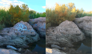
Graffiti Removal Project on the Lower Salt River and Saguaro Lake | Nicole and Justin Corey
The solution has been to paint over the graffiti, but the Natural Restorations founders and their volunteers were unsatisfied with this. Nicole and Justin started using a biodegradable agent and power washer and have been successfully tackling the graffiti problem ever since.
For trickier locations, members of the climbing community are recruited to help. The quicker they can get the graffiti removed, the less likely other rock faces in the surrounding area will be hit too. So far, they have removed 28,018 feet of graffiti and cover up paint in Sedona, the Florence Boulders and other spots along the Salt River and Tonto National Forest.
What is the secret to their success? “It is a multitude of reasons, but it comes down to how special the Salt River is to the community,” says Nicole.
The National River Cleanup® 2018 Photo Contest Winner | Tom Corey Images
Nicole has worked hard to build relationships with local businesses and schools. They work closely with veterans and recruit them to be on their Dedicated Restoration Team. Their strong community relationships and the help of their dedicated volunteers have allowed Natural Restorations to continue building momentum and raising awareness for their cause.
With her husband by her side, his dad taking awesome professional photos, a large team of kid, vet and community volunteers, Arizona waterways and public lands are becoming restored and better protected.
How Can You Make a Difference? “Always try to leave an area better than you found it, small acts can make a big impact over time,” says Nicole.
Anyone who plans to spend their summer on a river should avoid bringing plastic-foam coolers which can easily break and become toxic to wildlife. Bring a trash or onion bag to pick up trash and avoid bringing glass containers, which can also break and put you and others in harms way. If you see graffiti, promptly report it.
More ways to get involved:
- If you live in Arizona and are a veteran and/or interested in volunteering, check out Natural Restorations at naturalrestorations.org.
- Take the pledge to clean up our waterways!
- Organize your own cleanup or volunteer for one in your community.
- Take action to help stop a harmful diversion on New Mexico’s last major free-flowing river.
Congratulations again to and Natural Restorations and Tom Corey Images for winning the 2018 National River Cleanup® Photo Contest!
Four years ago, Bob Irvin, president of American Rivers, suggested to the U.S. Postal Service Citizens Stamp Advisory Committee that a set of commemorative stamps would be an excellent way to honor the 50th anniversary of the Wild and Scenic Rivers Act.
Today, we celebrated the release of the Wild and Scenic Rivers Forever Stamps with the U.S. Postal Service and partners at Oregon’s Tumalo State Park.
The event was a chance to honor the beauty of the 12 Wild and Scenic Rivers chosen for the stamps, captured by photographers Tim Palmer, Bob Wick and Michael Melford. And, it was an opportunity to thank the grassroots advocates, agency staff and champions in Congress who are working every day to leave a legacy of wild, free-flowing rivers for our children.
Here are some highlights from today’s first-day-of-issue ceremony:
David Moryc, Director of River Protection for American Rivers
Tim Palmer, author, photographer and former board member of American Rivers
Get your stamps and learn more.
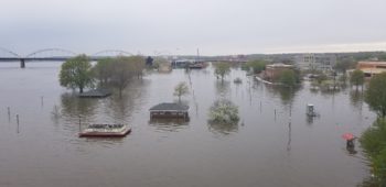
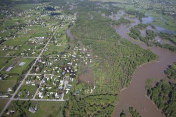
When the levee broke in Davenport, there was little warning. People were trapped in their homes and businesses and cars were left stranded in the road.
Thankfully, no one was killed or injured. But that might not be the case when the next levee breaks. Which is why I’m always slightly distracted these days, ears perked, straining to hear the air horns should another levee break.
Traveling around the Quad Cities is an exercise in patience. Multiple bridge approaches are flooded and train traffic that has been re-routed because of the flood blocks other major thoroughfares at a near steady pace. Even the Centennial Bridge, built to withstand a 100-year flood event, is buttressed by HESCO barriers and pumps as Davenport strains to keep it open.
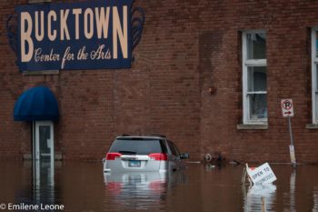
Flooding in Davenport, Iowa | Photo by Emilene Leone
The 100-year flood event is the critical marker for infrastructure and the Centennial Bridge in Davenport was built to span such an event. To see its approach flooded out is to witness something greater — a flood more severe than the almighty 100-year event.
Sadly, we aren’t the only ones with bridge problems. This past weekend the Champ Clark Bridge in Louisiana, MO was closed due to flooding. Located at Louisiana, MO, it is the only bridge that crosses the Mississippi for over one hundred miles and is a major transportation route connecting I-70 to I-72. Unfortunately the Champ Clark Bridge was not built to these “new” 100-year flood frequency standards and was totally swamped with the rising river.
During the Great Flood of 1993, bridge closures were cited as a major economic burden to the region, causing countless delays for people and goods, driving up prices, and closing local business. Experiencing these bridge and road closures begs two questions in my mind – Is the 100-year event still relevant? And, how can we bring our infrastructure up to date to deal with climate change?
Every year, someone on the Upper Mississippi River experiences a statically unlikely 100-year flood event and St. Louis seems to have at least a few 100-year events annually. Is the science and math behind the predictions of these events wrong, or simply out of sync with the current climate conditions? Or is something else going on? Likely all three.
With climate change, the Midwest is experiencing more frequent severe precipitation events, which means more snow in the winter and rain in the spring, which is a deadly recipe for Mississippi River flooding. Unfortunately, the flood frequency statistics are based on past rainfall data, which may no longer be relevant in our new and quickly changing climate. Additionally, the Mississippi basin is over engineered as communities pursue higher levees and more water moves off the landscape faster via an elaborate network of drain tile and channelized streams.
Flooding in Davenport, Iowa | Photo by Olivia Dorothy
This is why the Upper Mississippi River between Muscatine, IA and Hamburg, IL was listed among America’s Most Endangered Rivers. Along this 200- mile stretch of the Mississippi, several levee districts have over-built their levees and models show that their actions may be causing some parts of the Upper Mississippi to see almost 2 more feet of water.
So how can we plan better and improve our infrastructure to limit the transportation and associated economic disruptions? To start, we need to update the so-called “100-year” and “500-year” event profiles and flood maps with data based on more recent and projected precipitation trends. Bridge approaches need to be well outside of the updated 100-year events and other critical infrastructure needs to be moved out of the floodplain.
By moving such critical infrastructure out of the floodplain, it will allow the flood waters to slow down over the land, protecting vulnerable people and property.
We also need to get a handle on flood fighting. Today’s standard flood fight is every man for himself. But sandbagging creates another layer of unpredictability in an already chaotic natural disaster and levees are compromised by pushing sand up to the top from the base of the levee, making them taller, but weaker.
Instead of the current flood control approach to river management, state and federal agencies need to lead our region to a more reliable flood risk management strategy that uses more modern, nature-based flood risk management approaches, such as floodplain reconnection and restoration. Such a plan would assure residents that the flood water will go “here” and not “there,” because giving the river room to flood is the best way to protect people and property.
This blog is a part of our America’s Most Endangered Rivers® series on Bristol Bay, Alaska.
Pebble Mine. The project that just won’t go away.
In 2018, American Rivers ranked the Rivers of Bristol Bay as #2 on our annual list of America’s Most Endangered Rivers®. We have been fighting the development of a major mine called Pebble Mine in this area since at least 2006 (our first endangered rivers listing). In other words, for more than a decade, the threat of North America’s largest copper and gold mine has loomed over the headwaters of Bristol Bay, Alaska.
This project would directly impact the world’s largest and greatest sockeye salmon run, putting in jeopardy thousands of American jobs, a 10,000-year cultural tradition of subsistence, and a huge sport fishing and tourism economy.
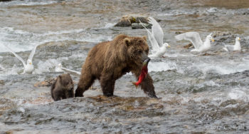
Bears in Katmai National Park | Photo by Cheryl Strahl
Today we have another chance to ensure the Pebble mine doesn’t put this all at risk. Please click here to comment today.
All told, the proposed Pebble mine would threaten an existing long-term sustainable economy valued at more than $1.5 billion annually, for a short-term mine.
The U.S. Army Corps of Engineers is reviewing Pebble Limited Partnership’s permit application and has released a document, called the Draft Environmental Impact Statement, intended to outline the risks and benefits of the proposed Pebble mine, after an extremely rushed and non-transparent process.
So, it’s no surprise that the 1,400+ page document landed with a pretty heavy thud in Alaska. The document shows Pebble’s proposal would permanently destroy more than 80 miles of streams and 3,500 of acres of wetlands. It makes clear Pebble’s current application is just the first step in what would become an industrial mining district in Bristol Bay; the economics don’t pan out any other way. That’s why a majority of Alaskans still oppose the proposed Pebble mine.
Bristol Bay | Photo by Kai Raymond
Please take a moment to stand up for the communities of Bristol Bay who rely on healthy fisheries and tell the Army Corps to deny this permit— click here to submit a comment.
It’s no time for complacency when it comes to Pebble mine. Please tell the agency reviewing Pebble’s most important permit to follow the science and stop the mine. Please take action today.
Also, if you live in Alaska, consider making your comments at a public hearing:
- Naknek: Monday, March 25, 3:30 PM – 7:00 PM at Naknek School
- Kokhanok: Tuesday, March 26, 3:30 PM – 7:00 PM at Community Hall
- Newhalen: Wednesday, March 27, 3:30 PM – 7:00 PM at Newhalen School
- Igiugig: Thursday, March 28, 3:30 PM – 7:00 PM at Igiugig School
- New Stuyahok: Friday, March 29, 1:00 PM – 5:00 PM at Community Building
- Nondalton: Monday, April 8, 3:30 PM – 7:00 PM at Tribal Center
- Dillingham: Tuesday, April 9, 4:00 PM – 9:00 PM at Elementary School
- Homer: Thursday, April 11, 3:30 PM – 9:00 PM at High School
- Anchorage: Tuesday, April 16, 12:00 PM – 8:00 PM at Dena’ina Center
_______________________________________________________________________
Last Tuesday, American Rivers released our annual report on America’s Most Endangered Rivers®. Have you had a chance to read about the rivers? You can check out all 10 of them here (don’t forget to TAKE ACTION while you are there)!
People across the country have expressed concern over these special places that are threatened by issues from water diversions to mining and dams to flood management and rampant development. A threat to all of the rivers across the country, climate change, was discussed in our announcement blog earlier this week.
One of the best things about our report on America’s Most Endangered Rivers® is that people… YOU… can do something to help. You can make an impact by going to our ACTION CENTER and sending quick emails to decision-makers on behalf of this year’s 10 endangered rivers. Please share these actions with your friends on social media as well so that we can really make an impact for these rivers!
Do you want to do more? Our supporters make it possible for us to highlight these challenges facing rivers year after year. We would love your support through a donation today. Thank you in advance.
Buffalo National River | Photo by Angela Peace
Now we can talk about why this has been a great week. First, as part of our report, we announced a success story through our River of the Year, the Cuyahoga in Ohio. The LOVE for this river has been pouring out from local residents and businesses. People are proud of how far this river has come in 50 years. Check out this great story from Yahoo News. You’ll be hearing more about this river in the coming months as we celebrate this important milestone.
On to the Top 10! The Weather Channel did a nice rundown of the full list of rivers, if you’d like a quick synopsis.
Our #1 river this year is the Gila River in New Mexico. The Gila is threatened by a massive water diversion project that could drain a significant amount of water from the river and leave downstream communities, farms and wildlife high and dry. As it is, this place is predicted to become ever drier as the climate changes and snowpack levels decrease over time. Heather Hansman at Outside Magazine discusses these challenges in this article. Also, if you really want to learn more about the history of the diversion project, you can check out this article in the New Mexico Political Report. In addition, we appreciated this statement from the Hispanic Access Foundation on the importance of the Gila to local communities.
Lower Green River | Photo by Ned Ahrens
American Rivers’ staffer David Moryc was out on Oregon’s Willamette River this week, talking on the news about the conflicts between dams and migrating salmon and steelhead. Another one of our staff members, Eileen Shader, can be heard on National Public Radio discussing issues with floodplain management and raising levees on the Upper Mississippi River in this clip.
The North Jersey Record discusses the various options on the table for placing storm surge barriers in the Hudson River. We want to make sure that climate change impacts beyond storm surge, such as sea level rise, are addressed in an environmentally sustainable way as part of this planning effort in the Hudson.
Flooding, climate change, and levees were also highlighted on Washington’s Green-Duwamish River this year. You can hear more about it in this clip.
Chilkat River | Photo by Colin Arisman
American Rivers has two rivers in Alaska on the list this year— the Chilkat and the Stikine. Mining threatens native and local communities and salmon who depend on these rivers to survive. Kimberley Strong, President of the Chilkat Indian Village of Klukwan, discusses the concerns of the tribes in this piece.
Mining is also an issue for Idaho’s South Fork of the Salmon River, which has made the list for a repeat second year in a row. You can read about it in this article. Another repeat is Arkansas’ Buffalo National River, which we thought was saved when a hog farm permit was denied by the state, but then a legal battle ensued. We need the Governor of Arkansas to hold strong and protect the health of the river! You can hear more about that story here.
Last, but certainly not least, the Big Darby Creek near Columbus, Ohio, is threatened by a big development project. You can read more about the issues surrounding that project here.
We can’t make a difference for these rivers without your help! Please don’t forget to TAKE ACTION NOW and share with your friends so that we can save these magnificent rivers!
In Indiana, a woman clutches her small dog and a few belongings as she wades through waist-deep floodwaters, her ruined home visible in the background.
In Texas, a rancher kicks at the dry earth and remarks that there should be grass here now, not billowing sand.
In Ohio, a mother and her two kids haul bottled water into their kitchen, their tap water rendered unsafe to drink by toxic algae.
These are the faces of climate change, the warming of the earth’s atmosphere fueled primarily by the burning of fossil fuels and the impacts of that warming on long-term weather patterns. For decades, scientists have warned of rising temperatures and the potentially devastating impacts of a warming planet, and that those impacts would strike freshwater systems – rivers, lakes, wetlands, the hydrologic cycle itself – first and hardest. Today, the evidence is irrefutable. Global temperatures have been swiftly on the rise – the last five years have been the hottest on record. And in places like Indiana, Texas, Ohio and across the country, people are seeing, suffering, and paying for those impacts every day. The cold, or rather, warm hard facts are these:
- In 2017, Hurricane Harvey produced the single most intense rain event in recorded U.S. history, and the U.S. could see up to an additional 400% increase in extreme downpours by the end of this century.
- By 2050, 32% of U.S. counties will be at high or extreme risk of water shortage
- In 2017, there were over 170 toxic algae blooms recorded in the U.S.
- Economic losses from extreme weather totaled $653 billion over the past two years alone.
Flint River, GA | Photo by Alan Cressler
Ever greater and more intense flood, drought, and fouled water – what’s happening? It’s the basics of physics and weather driven to extremes by global warming. The warmer air and oceans create storms of increased intensity and duration that pick up and hold ever more amounts of water as they move, producing rain storms in the southern and midwestern U.S. unprecedented in their frequency and intensity. In more arid parts of the country, particularly the Southwest, rising temperatures affect rainfall, humidity and wind patterns, drying the soil and increasing the pace of evaporation, aggravating and expanding areas of drought. And warming water temperatures create ideal conditions for explosive algae growth, creating the potential for more toxic blooms that foul urban source water intakes and render freshwater undrinkable.
But we have always had floods, droughts, and water pollution events, right? Sure. It’s not that these things are new. It’s that due to climate change they’re happening with much more frequency and severity, exacting an ever-greater toll in lives, property, and the health of human and natural communities. People and communities, wildlife and habitats, rivers and streams, are adapted to a set of conditions – temperature ranges, rainfall amounts, snowpack, flows – that have been more or less predictable for thousands of years. Climate change is scrambling all of that, with devastating results.
Clark River, MT | Photo by Kestrel Aerial Services
At a dark point in World War II, a small turn of fortune in the long struggle prompted Winston Churchill to hopefully observe, “This is not the end. It is not even the beginning of the end. But it is, perhaps, the end of the beginning.” After decades of controversy, much of it contrived by the fossil fuel industry and its boosters, those that deny the existence of climate change, its impacts and its causes are a swiftly shrinking minority. The evidence, both the scientific and “seeing-is-believing” varieties, is so overwhelming that attention is turning to where it should be – what to do about it.
Fortunately, there are solutions. Through global accords like the Paris Agreement, the countries of the world are at long last moving to set and pursue ambitious targets for reducing the build-up of carbon in the atmosphere by reducing dependence on fossil fuels, reforestation, changes in agricultural practices and other means, aiming to slow and ultimately reverse global temperature rise. Alternatives to fossil fuels, renewable, low carbon sources of energy such as wind and solar once thought to be at best uneconomical and at worst a pipe dream, are increasing production at a spectacular rate. Growth in the production of wind energy since 2001 has exceeded expectations by 2000%. Solar energy has done even better, producing at a pace 109 times expectations. And as costs of production drop dramatically and energy storage technologies improve wind and solar are becoming increasingly attractive options in energy markets. Between government action, market forces, and consumer demand for clean energy, hope increases that a sharp drop in fossil fuel use world-wide will halt and reverse rising global temperatures. There is a tremendous amount left to do, and it will take a long time to do it. It’s still an open question whether the world, particularly the United States, will summon the political will to truly confront climate change. But we may have reached the end of the beginning.
Talkeetna River, AK | Photo by Scott Bosse
However, strategies to reverse global climate change will require many years to take hold, and its effects are already being felt. In the meantime, we must work to make natural systems like rivers, streams, lakes and wetlands as resilient as possible to climate change and its effects. That’s where the work of American Rivers comes in. Healthy, well managed rivers systems, including headwaters, wetlands, and floodplains, are an important bulwark against climate change, providing buffers against water shortage, helping relieve damage from floodwaters, ensuring water quality, and providing refuge for fish and wildlife.
American Rivers’ river protection initiatives prevent infrastructure, mining and oil and gas development from degrading healthy rivers, preserving them as sources of water supply and refugia for fish and wildlife under increasing pressure from climate change. Our restoration programs reconnect fragmented rivers, opening pathways for fish to escape increased temperatures and saltwater intrusion. The work of our floodplain restoration and management team relieves flood pressure on communities by giving rivers the room they need when rain events overwhelm their banks, and our clean water programs help cities manage water resources and promote green infrastructure to keep urban water supplies clean. American Rivers’ policy staff promotes government investments in better floodplain management, drought contingency planning, and protection of small streams and wetlands for their importance to downstream supply and quality.
On this Earth Day, we need to redouble our commitment to taking on climate change every day, by doing everything we can to bring global temperatures down and ensuring that its inevitable impacts are minimized. Experts maintain that the best defense against the impacts of climate change is healthy and resilient ecosystems. Fortunately, protecting and restoring freshwater ecosystems has been American Rivers’ business for over 45 years.
Happy Earth Day, everyone!
It’s official. In early April, the House of Representatives and the Senate approved the seven-basin state’s Drought Contingency Plan (DCP) and on April 17th President Trump signed the bill into law. The speedy response from Washington allows the seven-basin states to act immediately to protect the Colorado River.
As we noted in an earlier post about the DCP, the plans are two separate, yet coordinated efforts for both the Upper and Lower Basins. By design, the plans work in tandem to better manage the shifting strains on the Colorado River system. The Lower Basin plan focuses on water reductions to stabilize water levels in Lake Mead, while the Upper Basin DCP establishes a regulatory pool of “conserved” water in Lake Powell (to be used as a bank for the Upper Basin), allows for reservoir reoperation and continues cloud seeding to improve snowpack.
The plans are a culmination of three years of hard work, collaborative compromise, and tense, yet vital, negotiations. The plans are complex, but were developed with a sense of urgency to prevent an immediate water crisis by creating incentives for water conservation and mechanisms for sharing and leasing water, while preserving existing rights, agricultural realities, and the long term support for the Colorado River.
Now that the plans have been approved by Congress and signed by the President, what’s next?
Now that the plans are authorized by the Federal Government, they go back to the states to be officially authorized. Then, the states can begin the implementation of the plan. Carrying out the plan looks different for every state, so while the plans are finalized, there is still much work to be done at the state level to implement the DCPs.
In Colorado, the Colorado Water Conservation Board (CWCB) is launching a feasibility study of a demand management program. is one of the ways Colorado (and the Upper Basin) is working to avoid “mandatory” cutbacks in water use. It works by creating a water market, where willing participants may choose to be paid changing how they use their water. For instance, a ranch may choose to change to a lower water-use crop or turn off their water to temporarily fallow a field. Conserved water will then be delivered through rivers and stored in the new, reserved “pool” within Lake Powell. The CWCB is studying this potential program to understand the opportunities and concerns from stakeholders around the state to hopefully develop a voluntary, compensated, and temporary demand management program that reduces water security risk and works for water rights holders and Colorado’s rivers as well.
To reduce the impact of mandatory cuts the state would take when Lake Mead levels hit 1,075 feet, Arizona agreed to additional, voluntary cutbacks at 1,090 feet. At the time of writing, the surface elevation of Lake Mead is 1,089.72ft. This means Arizona will reduce their Colorado River water allocation, primarily impacting agricultural users in Pinal County (most junior water users in Arizona). If and when levels in Lake Mead reach 1,075ft, then 1,050ft, then at the critical level of 1,025ft, additional reductions will occur in Arizona, Nevada and eventually California.

While the specific reduction levels are identified, exactly how they would actually be implemented is not yet finalized. As a part of Arizona’s work to implement the DCP, they will need to consider how to curtail water use as to reduce potential impacts so that municipalities, agriculture and the environment are preserved. The DCP also provides a mechanism for Mexico to participate as well, storing some of it’s water in Lake Mead to support those elevations as well.
In addition to implementing the DCP, the seven-basin states will soon be back at the negotiation table. In 2020, the renegotiations of what are known as the 2007 Interim Guidelines for Lower Basin Shortages and Coordinated Operations for Lake Powell and Lake Mead will begin. It’s important that as renegotiations start to shape up, stakeholders continue to collaborate in an effective manner. The river doesn’t follow political or geographic boundaries, but instead flows from its high, headwaters sources in Colorado and Wyoming into Mexico. We must also seriously consider climate change impacts, long-term planning and innovative, creative solutions to reduce water demand and keep rivers in the Colorado Basin healthy and flowing.
American Rivers is very involved at many levels in all of these negotiations. We are at the table in Arizona, and working diligently to help the Water for Arizona Coalition continue working with elected officials to both pass and implement the Arizona and Lower Basin DCP, while working to address the looming threats to Arizona’s groundwater withdrawals. We are also heavily involved in the development of the Upper Basin Demand Management program to support the Upper Basin DCP. Lastly, we are helping to lead the efforts to continue to advocate for full implementation of the Colorado Water Plan. Holistically, these efforts overall are guided by one key principle – doing what we can to promote the overall, system-wide health and vitality of the Colorado River. We are American Rivers, protecting rivers is what we do best.
Flooding, drought, storm surge and sea level rise: America’s Most Endangered Rivers® of 2019 spotlights the threat that climate change poses to rivers, clean water supplies, public safety and communities nationwide.
From water scarcity on New Mexico’s Gila River, named the #1 Most Endangered River in the country, to sea-level rise on the Hudson and flooding on the Upper Mississippi, America’s Most Endangered Rivers of 2019 illustrates what’s at stake and the choices facing communities.
Now in its 34th year, America’s Most Endangered Rivers® is a call to action. It spotlights rivers at a crossroads, where key decisions in the coming months will determine the rivers’ fates. Get the full report and take action.
Climate change is the most consequential environmental challenge facing our planet. In the U.S., cities are struggling to do more with less water, fish and wildlife are struggling to survive, forest fires are growing more destructive and storms are triggering more life-threatening floods. Just last month, record flooding across the Midwest killed at least four people and cost more than $3 billion in property damages in Nebraska and Iowa. The harshest impacts of climate change are often most prevalent in communities of color and economically disadvantaged communities.
The Hudson River | Photo by Dan Nguyen
The National Climate Assessment released in 2018 states, “Water quality and water supply reliability are jeopardized by climate change in a variety of ways that affect ecosystems and livelihoods…Very heavy precipitation events have increased nationally and are projected to increase in all regions. The length of dry spells is projected to increase in most areas, especially the southern and northwestern portions of the contiguous United States.”
The top three rivers in America’s Most Endangered Rivers of 2019 demonstrate how climate change is already having an impact, and how our actions will either weaken or strengthen river communities:
- #1 Gila River – The Southwest is becoming hotter and drier due to climate change. Building a costly new diversion and compromising river health doesn’t make sense when there are cheaper, more effective water supply alternatives for the region.
- #2 Hudson River – Rising sea levels resulting from climate change threaten New York City. Instead of installing massive storm-surge barriers that would damage this rich estuary ecosystem, we must find better, more reliable and flexible solutions to protect people and property.
- #3 Upper Mississippi River – Increased flooding is occurring throughout the Upper Mississippi basin due to climate change. Choking the river with new levees and traditional flood control structures threatens public safety by making flooding worse downstream.
The South Fork Salmon River | Photo by Nate Ostis
Climate change and the rising temperatures, droughts, floods, and impacts to water quality it brings with it threatens to undermine the ecological health of rivers across the country. America’s Most Endangered Rivers of 2019 are jeopardized by pollution, urban sprawl, mining, poor infrastructure management as well as drought and floods. Protecting and restoring rivers to ensure their resilience in the face of such threats is essential to meeting the challenge of climate change.
Our nation is at a crossroads. If we continue to degrade and abuse our rivers, we will compromise our ability to deal with increasingly severe droughts and floods. But if we protect and restore our rivers in thoughtful and equitable ways that do not perpetuate the mistakes of the past, we can strengthen our communities and create a more secure future.
AMERICA’S MOST ENDANGERED RIVERS® OF 2019
#1 Gila River, New Mexico
Gov. Lujan Grisham must choose a healthier, more cost-effective way to provide water to agriculture than by drying up the state’s last major free-flowing river.
#2 Hudson River, New York
The U.S. Army Corps of Engineers must consider effective, nature-based alternatives to storm-surge barriers that would choke off this biologically rich tidal estuary.
#3 Upper Mississippi River, Illinois, Iowa, Missouri
State and federal agencies must enforce laws that prohibit illegal levees, which increase flood risk for communities and degrade vital fish and wildlife habitat.
#4 Green-Duwamish River, Washington
Local leaders must produce a flood protection plan that safeguards communities and restores habitat for chinook salmon — fish that are essential to the diet of Puget Sound’s endangered orca whales.
#5 Willamette River, Oregon
The U.S. Army Corps of Engineers must immediately improve 13 dams to save wild chinook salmon and steelhead from going extinct.
#6 Chilkat River, Alaska
The Japanese investment firm, DOWA, must do the responsible thing and back out of a mining project that could decimate native salmon.
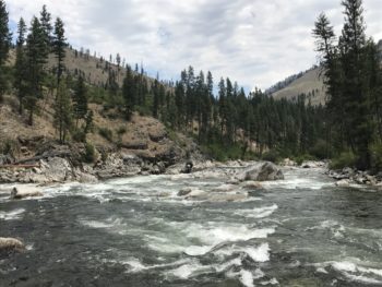
#7 South Fork Salmon River, Idaho
The U.S. Forest Service must safeguard endangered fish by denying a mining proposal that could pollute this tributary of the Wild and Scenic Salmon River.
#8 Buffalo National River, Arkansas
Gov. Hutchinson must demand closure of an industrial hog-farming facility that pollutes groundwater and threatens endangered species.
#9 Big Darby Creek, Ohio
Local leaders must use state-of-the-art science to craft a responsible development plan that protects this pristine stream.
#10 Stikine River, Alaska
The International Joint Commission of the United States and Canada must protect the river’s clean water, fish and wildlife, and indigenous communities by stopping harmful, polluting mines.
Spring is here, temperatures are warming to above freezing and steelhead fish are running again in The Grand River. A vital resource to the Great Lakes region, The Grand River flows 246 miles across Michigan, through the City of Grand Rapids and into Lake Michigan. The Grand River attracts the largest annual migration of steelhead in the Great Lakes and is also known for accommodating world-class salmon, small mouth bass, walleyes and other species. In this region, the steelhead call Lake Michigan home, but about every 4 years, steelhead return to spawn in the stream in which they were born, making the Grand River a premier fishing location. In Grand Rapids, anglers also enjoy the unique experience of fishing in an urban setting. They cast their lines downtown in the river or on the banks, within a few minutes’ walk to a variety of local breweries, eateries, museums and shops. An important commodity to industries, and significant to the ecosystem of the Great Lakes, The Grand River also provides recreation for paddlers and anglers.
On a sunny Saturday in late March, I arrived at Fish Ladder Park, in the heart of downtown Grand Rapids, to find anglers on both sides of the river banks with their poles dropped in the water. Even small fishing boats have access to the river nearly 20 minutes downstream from the popular fishing spot near the Sixth Street Dam. Fish Ladder Park provides access for all community members and visitors to watch the fish during seasonal migration. The park includes a functioning art structure designed by artist, Joseph Kinnebrew, known as a “fish ladder”, allowing fish to “jump” through a rapid feature that assists them in migrating around the large dam. I was lucky to visit on the first warm day of the season, after rain and snow melts the river was high. Many people were fishing, strolling the riverfront paths or stopping by to catch a peek at the steelhead migration.
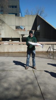
Paul and his catch | Photo by Shanyn Viars
Among the anglers that Saturday was Paul. (pictured) Local anglers like Paul grew up fishing in the Grand River and look forward to the spring when the steelhead start to run. Living and working in Grand Rapids, the anglers care about The Grand River’s quality and aquatic life it supports. As Paul and others stood along the banks, casting in lines and trading tips, they shared their river stories with me.
Grand Rapidians are passionate about their river and appreciate the recreational opportunities it provides, like having public parks and walkways along the river banks, as well as fishing. Community members like Rachel, a young mom that works in the city, have fond childhood memories of spending Saturdays at Fish Ladder Park with parents and siblings, watching the anglers fish in The Grand River. Rachel would wait anxiously to see if anyone got lucky with a “great catch.” Her early experiences on a healthy river grew into many more fond river memories that include paddling and tubing on river trails throughout the state, and volunteering in her community for river clean-ups. Not all community members have such fond childhood memories of the Grand River; decades ago the river appeared to be on the verge of collapse.
Historically an important trading route, The Grand River, or O-wash-ta-nong, (Far-Away-Water) provided critical resources for tribal communities living in the region. Detailed accounts from historians speak of 10-foot tall rapids cascading through its namesake city, Grand Rapids. By the mid 1800’s, the logging industry was booming, cities were growing, and dams were being built for hydropower and support urban growth. Growing trade and industrialization over the first half of 20th century had put The Grand River on a clear path of environmental decline. According to The Muskegon Chronicle’s Grand River Series, a newspaper article from 1910 predicted the Grand River to be “more of a sewer than a river by 2005.”
By the mid 1900’s the Grand River was filthy; “you didn’t want to fish, swim or be near the river,” a retiree, George recalls. He grew up with stories from parents and grandparents about sewer overflows and industrial pollution that once plagued this important water body. With the help of policies like the Clean Water Act (1972) and local action from community members and environmental advocates like West Michigan Environmental Action Council (WMEAC), efforts to repair and protect this water body were underway. While the Grand River is now, as reported by The Muskegon Chronicle’s Grand River Series, healthier than it has been in the last 100 years, significant problems remain.
Anglers on The Grand River | Photo by Shanyn Viars
Thanks to efforts by local leaders to improve water infrastructure and community advocates like WMEAC that have dedicated over 50 years of river clean ups and environmental education, the quality of the river has much improved. Increased recreation in the Grand River has led to the creation of riverfront development plans, including plans to restore the rapids and proposed dredging. Anglers like Paul, and community members like Rachel, fear the past has been forgotten and plans that promise economic growth to the region may decrease the quality of the City’s most precious natural asset.
Despite The Grand River providing experiences most people living in urban areas can’t access, some seem to take this natural resource for granted. WMEAC and the local community it supports, are once again fighting for their right to access clean waterways and healthy rivers. Unfortunately, a current plan for the waterway proposes dredging 26 miles of The Grand River, risking the quality of this vital resource once again. The Waterway Plan intends to dredge over a century of contaminated sediment resting at the bottom of the Grand River to allow powerboats and yachts to travel the river from Lake Michigan to the City of Grand Rapids. With a lack of amenities, harbors, or fueling stations, large boats could take up to 7 hours to make the commute one-way through “no wake zones.”
Although not uncommon, dredging is mostly used in shipping navigation, mining, and construction activities or to clean-up the environment from pollution spills. But this urban river is no Suez Canal and even the effects of environmental dredging are controversial. Removing large quantities of contaminated sediment to land can have huge environmental impacts, not only to aquatic habitats but to the land and other species as well as human health.
In an estimate by the Anderson Economic Group, the Waterway plan proposes an economic impact of $5.7 million annually from increased visitor spending with a projected $614,000 increase in collected property taxes for municipalities. The project is expected to cost an estimated $2.15 million with hundreds of thousands in annual maintenance costs, with no word on who pays the bill. The economic assessment excludes cost related to environmental degradation associated with dredging up contaminated sediment, or the cost of expected soil erosion along the river banks due to increased boat traffic. The report also lacks the cost of additional air, water, land and noise pollutants or containments produced from power boats and increased human activity.
It is also important to highlight that dredging is not a one-time activity and would need to be preformed repeatedly to support this type of waterway. The report also lacks any socio-economic implications associated with the expected increase in property values along the river banks. Without input from community members, the project assumes people living along the river banks want their property values increased and would be able to pay higher property taxes that tend to follow a project such as this. To put it simply, this plan lacks critical local information from the community of neighbors that live near or on the banks of The Grand River as well as the visitors that fish and paddle in the river and those that have been fighting for many years to increase the quality of the Grand River.
A fish ladder along The Grand River | Photo by Shanyn Viars
On this spring Saturday afternoon, concerns of proposed river projects like dredging aren’t far from anglers’ minds as they toss in their lines. They shared recent changes they’ve seen in the river, like the disappearance of a small peninsula that stretched across part of the river caused by recent construction along the river banks. Further impacts from dredging and other projects that lack environmental considerations concerns anglers about the impacts to the variety of migratory fish that spawn in The Grand River. Before long, Paul’s efforts paid off, he was pulling in male steelhead trout from the line. After the excitement wore off, and “selfies” of the catch were captured, he took time to tell me how local anglers appreciate the now thriving habitat of fish The Grand River provides. To do their part to maintain a healthy species, in a manner of unspoken law, most anglers won’t keep female steelhead, especially during migration when they are spawning.
Several riverside parks in and around the banks of The Grand River provide a variety of recreation opportunities for the city. The steelhead migration makes Fish Ladder Park particularly “trendy” this weekend with change to spring, higher waters, higher temperatures, many onlookers and anglers are enjoying this opportunity. But these natural amenities, also vital to community health in urban areas are only available today thanks to the efforts of local advocates educating the community and public leaders that have fought tirelessly to restore The Grand River back to health. For now, the steelhead are here and anglers like Paul, can snag a great catch and be home in time to see both Michigan teams play in the Second Round of NCAA Championship games.
American Rivers supports the recent attention West Michigan Action Council (WMEAC), and local advocates are illustrating in speaking out against the Waterway Plan to dredge the Grand River. Particularly in urban areas, community members want the access to enjoy the recreation opportunities a healthy Grand River provides to them and their families. To learn more about advocating against dredging or other local environmental concerns in West Michigan, visit WMEAC at www.wmeac.org.
- Organize a cleanup with National River Cleanup®, or sign up for an existing cleanup near you
- Learn more about recycling with our National River Cleanup® recycling guide
- Take our River Cleanup Pledge to pick up trash and help us fill our virtual landfill
- And more!
Collaborative processes and negotiations are often easier said than done. For almost one hundred years the Colorado River has been managed by the “Law of the River.” Starting with the 1922 Colorado River Compact, the Law of the River is a series of negotiations, compacts and a few lawsuits guiding the allocation of water to states across the Basin. I would bet, that if you asked the many participants in the negotiations making up the Law of the River, they would tell you that they were not easy given the high stakes and the wide variety of interests at play.
Components of the Law of the River have traditionally been negotiated by a few main players, including individual state governments, federal governments (the US and Mexico) and water providers (including irrigation districts and water utilities). However, in the last 25 years or so, voices at the table have shifted to include other water users, including Tribes and nonprofit stakeholders. These stakeholders provide critical viewpoints to fully evaluate how water should be allocated and managed across the basin, particularly in times of drought and shortage. The work to engage these stakeholders, particularly Colorado River Basin Tribes, must continue to evolve to ensure all water right holders are considered during critical negotiations.
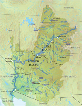
Map of the Colorado River
In mid-March, a critical negotiation milestone was reached on the long-awaited Drought Contingency Plans (DCP). As a reminder, the DCPs are two separate, yet coordinated plans for the Upper and Lower Basins that work collectively to better manage the shifting Colorado River System. The plans are complex but were developed to prevent an immediate water crisis by incentivizing water conservation while preserving existing uses and rights, agriculture and the environment.
Similar to other negotiations in the Basin, finalizing the DCPs was no easy feat. For those of us living in and depending on the Colorado River Basin, we understand the effects that aridification and drought has had on the river and the many uses it supports. The sheer value of the economy supported by the river is estimated to be about $1.4 trillion, and water from Colorado River water is essential to the region’s widely diverse way of life.
In Colorado (and the other Upper Basin states of New Mexico, Utah and Wyoming), demand management is a critical component of the Upper Basin DCP. Demand management is a voluntary program that compensates farmers, cities and other water users to reduce use without losing their water rights. Once a part of the demand management program, the water is left in the river to flow downstream to Lake Powell where it is “banked” to reduce water supply risk to the Upper Basin if drought persists. On its journey down to Lake Powell, the saved water provides substantial environmental and recreational benefits for the river. Our new explainer video does a great job of illustrating why demand management is important for the river and the Basin as a whole.
Demand management is just one of many solutions identified in the DCPs to reduce demand on the river. Identifying and implementing these solutions allows water users to share the impacts of potential shortage and be prepared to address them when they occur. The cooperative efforts surrounding DCP negotiations allowed the seven states to reach a critical juncture on March 19th when representatives from the seven Colorado River Basin states gathered in Phoenix to sign a joint letter to Congress, encouraging lawmakers to address the crisis in the Colorado River Basin. The states urge Members of Congress to pass federal legislation to implement the DCP. According to the agreement with the Bureau of Reclamation, Congress must act by April 22nd.
Collaborative negotiations are not easy but lead to everyone toward being able to commit to doing the hard work to develop and prove solutions that can work across multiple stakeholders, and ultimately for the health of the river as well. Taking the time to sort out the challenges and opportunities rather than simply projecting simplistic, one-sided solutions, allows everyone to participate and frame the necessary solutions. While not a silver bullet, efforts to pass the DCPs in both the Upper and Lower Basins is truly something to celebrate as we work towards better management of the Colorado River well into the future.