To our American Rivers family,
All of you – our supporters, partners and friends – are in my thoughts during these challenging times. I wanted to let you know how our organization is adapting to keep ourselves and our communities safe, and how we are continuing our important work for rivers and clean water.
We closed our headquarters and field offices on March 13 and staff have been working from home. We cancelled all work travel and postponed National River Cleanup® events. We are moving forward with the release of our report, America’s Most Endangered Rivers® of 2020, on April 14, which will spotlight solutions for rivers and communities in the face of climate change.
I am grateful for the continued support of our dedicated members and donors. And, I am grateful for our staff, who continue to do an incredible job under difficult and unprecedented circumstances.
This pandemic is devastating families and communities nationwide. It is disrupting so many aspects of our lives. In the midst of the fear and uncertainty, I’ve been reflecting on the persistence of rivers. I recently came across this line by the poet Alex Dimitrov: “Time is a river. That river is always in motion. And motion is hope.”
We will get through this. Our work will continue. And when individuals and communities are ready to heal, their rivers will be there: a source of health, strength and opportunity.
A source of life.
I’ve always loved our tagline, Rivers Connect Us. In this time of social distancing, I’m feeling the power of that statement more than ever. Rivers connect us to each other, to the wonder of the natural world, and to our future.
American Rivers has been advancing solutions for healthy rivers and communities for nearly 50 years. And together with you, we will continue — doing everything in our power to make our shared future prosperous, beautiful and bright.
Bob
P.S. – To pass the time, and to fill your heart and mind with positive stories while you are staying home, watch one of our short films, listen to our We Are Rivers podcast, or – if you have kids at home — download our learning guide for parents and teachers.
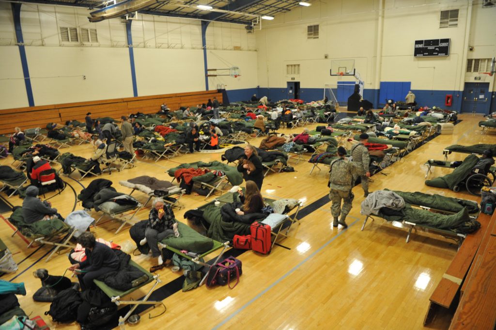
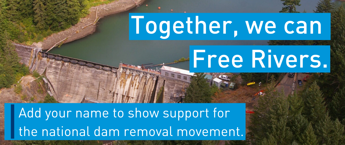
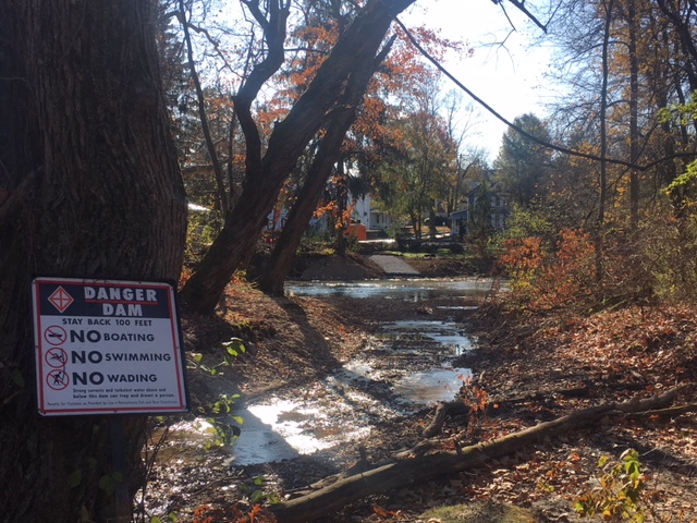
It’s been three years since our nation’s tallest dam, Oroville Dam, partially failed, forcing downstream evacuations, environmental damage, and costly emergency repairs. In the wake of the main spillway failure, a host of environmental groups (including American Rivers), the public, and governmental agencies responded. The takeaway was clear: dam safety across the United States needs to be improved. As America’s infrastructure continues to age and faces new threats posed by our changing climate, we need to be more proactive about making updates to the structures we rely on for public safety and resources.
Aging Infrastructure, Changing Climate, Increased Risk
“70% of the nation’s dams are over 50 years old. [They were] built with the best engineering and construction standards at the time; however, as the scientific and engineering experience has increased, many dams are not able to safely accommodate our current prediction of large floods and earthquakes” (American Society of Civil Engineers). The dams in the US collectively earned a ‘D’ on the ASCE report card released in 2017 (you can view the report here). Dams were not individually ‘graded’ in the report card, but Oroville is one of 15,498 (17% of catalogued dams nationwide) that have been identified as high-hazard potential dams, meaning that they pose a significant threat to human life or property if they fail.
Downstream Communities and Ecosystems
As the high-hazard grade would imply, this dam’s failure had serious ramifications for communities and ecosystems downstream. The Association of State Dam Safety Officials (ASDSO) stated that, “The Oroville Dam spillway incident was caused by a long-term systemic failure to recognize and address inherent spillway design and construction weaknesses, poor foundation bedrock quality, and deteriorated service spillway chute conditions.” It is now clear that the spillway was built on unstable bedrock (Independent Forensic Team Report Oroville Dam Spillway Incident) and as a result the concrete separating the bedrock and thousands of gallons of water per second rushing over the spillway was worn paper-thin over its years of use. This resulted in the concrete coming off the hillside in large chunks as the water eroded it away. Meanwhile, the emergency spillway’s efficacy had never been tested, so when it was forced into use, it too eroded the hillside. The Department of Water Resources (DWR) was left with no choice but to order the evacuation of the three counties (188,000 people) that would be impacted in the case of a complete dam failure.
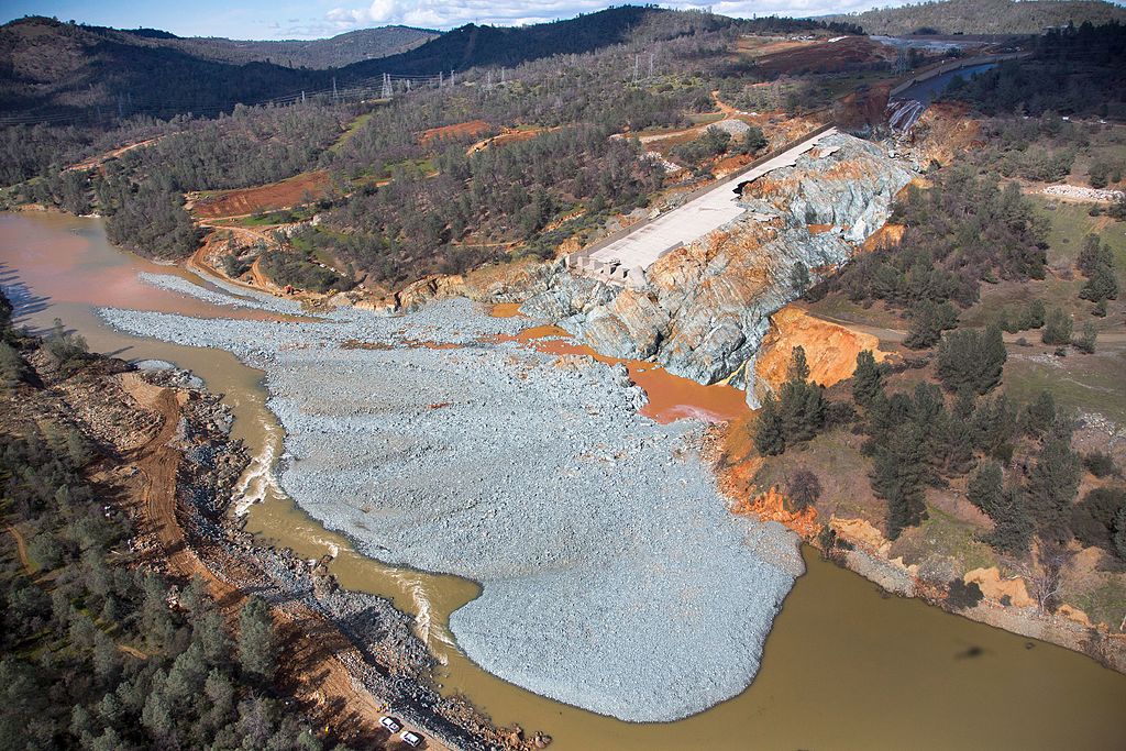
The spillway failure in 2017 was more than a scare, it had negative impacts on downstream communities, ecosystems, and the dam owners; the evacuation displaced thousands of people, negatively impacted the ecosystem by washing tons of sediment downstream, and cost DWR over $1 billion to repair (which does not include the economic impacts on the community). Salmon and steelhead fisheries were already impacted by the construction of the dam, which blocked them from reaching their natal spawning grounds. After the spillway failure, sediment from the hillside choked out miles of habitat and anything living there.
Updating Infrastructure in the Face of Climate Change
Since February 2017, DWR has completed the reconstruction of the main spillway so its foundation is better anchored into the bedrock, reinforced the emergency spillway with concrete (though it still is not safe to rely on that spillway regularly), among other projects. Oroville Dam is looking stronger, but there’s still a lot of work that needs to be done to reduce its public safety risk. It is not alone: thousands of dams need to be dramatically updated or run the risk of failure.
notice at Beale Air Force Base | Photo by U.S. Air Force
Photo/Airman Tristan D. Viglianco
Updating our infrastructure is important, but it’s critical that it’s done in a way that is relevant to the context we live in: a changing and increasingly variable climate. More extreme weather events such as floods or drought have become commonplace. These climatic variations put increased strain on the infrastructure in terms of ability to function during extreme weather events (i.e. hydroelectric power generation during droughts and ability to safely store water in a Probable Maximum Flood). Even since DWR reconstructed both spillways on Oroville Dam, the release capability still falls short of the standard for a Probable Maximum Flood situation, putting the dam and the people and ecosystem downstream at risk (Independent Forensic Team Report).
A New Approach to Dam Safety
The bad ASCE report card grade proves that we need to be proactive about monitoring dams to avoid disasters like what happened in 2017, especially when the environment in which they exist is changing as well. At the same time, dam safety departments nationwide are insufficiently funded and staffed and cannot keep up with thousands of dam inspections that need to happen annually. To alleviate some of the pressure on under-resourced agencies, some states are now requiring private dam owners to either pay for their inspections through annual fees or directly hire qualified engineers to complete inspections and submit inspection reports to the states. These approaches dramatically increase the capacity of dam safety offices and hold owners accountable, therefore increasing the overall safety of dams.
American Rivers is a leader in creating innovative solutions for water storage. For dams whose impacts exceed their benefits, American Rivers has long advocated that the most effective approach to dam safety is dam removal.
On Friday, February 28, the U.S. Army Corps of Engineers, U.S. Bureau of Reclamation, and Bonneville Power Administration released a draft environmental impact statement addressing the latest plan for operations of the hydropower dams on the Columbia and Snake rivers. Five plans have failed already, rejected by courts as illegal and inadequate for saving endangered salmon, and the same fate likely awaits this one.
Salmon-dependent communities across the Pacific Northwest feel like Bill Murray in Groundhog Day, reliving the same day over and over again. We’re looking at yet another Snake River salmon recovery plan that will almost certainly fail and is unlikely to survive legal challenges. Isn’t it time for new solutions?
For 20 years, the federal government and Northwest ratepayers have made investments totaling more than $16 billion in salmon recovery in the Columbia-Snake Basin. These actions have been necessary to lessen the impacts of historic habitat loss, over-harvest, and the impacts of hydropower, but are not sufficient to recover salmon and steelhead to healthy, harvestable and sustainable numbers.
It’s clear this environmental impact statement will not provide a comprehensive solution for our salmon, energy and agriculture needs, nor will it address how the federal government will uphold its obligation to Columbia River treaty tribes. At American Rivers, our goal is not to simply avoid extinction, but to have our region thrive. And we’re not alone. Stakeholders across the region are eager to craft a comprehensive solution that brings communities together—rather than pitting them against one another. Strong leadership can help us solve each other’s challenges.
Our leaders are stepping up. Washington Governor Inslee, Oregon Governor Brown and Idaho Governor Little are spurring important dialogue about how we might reimagine our relationship with the Columbia and Snake rivers and ensure a future of abundant salmon, clean affordable energy and thriving agriculture. Key members of the Northwest Congressional delegation, who ultimately will need to craft a comprehensive legislative solution, are also supporting constructive conversations.
We share common values, and we can work together to address everyone’s needs. That’s why farmers are speaking up for salmon recovery. Fishermen are supporting upgrades to grain transportation. Businesses want investments in clean energy. We must focus on what connects us and commit to meeting the region’s energy, agricultural and conservation challenges together. The way forward is together.
What’s next?
- With the release of the DEIS release, a 45-day comment period invites public input. There will be a series of public hearings in March at locations around the Northwest. Public hearing dates and locations listed below.
- The final EIS is expected in June of 2020 with adoption of a new plan by September 2020.
How can you help?
- Attend a public hearing to learn more about the process and to speak on behalf of salmon, healthy rivers and healthy communities.
- Lewiston, ID | March 17 | 4 – 8 pm — Red Lion Hotel
- Kennewick, WA | March 18 | 4 – 8 pm — Red Lion Hotel
- Seattle, WA | March 19 | 4 – 8 pm — Hilton Seattle Airport
- Spokane, WA | March 25 | 4 – 8 pm — DoubleTree City Center
- Kalispell, MT | March 26 | 4 – 8 pm — Red Lion Hotel
- Portland, OR | March 31 | 4 – 8 pm — Oregon Convention Center
- Thank Governor Inslee for his leadership in bringing stakeholders together to chart a shared path forward.
- Thank Governor Brown for Oregon’s steadfast leadership on this issue and her recent call for collaborative, regional solutions.
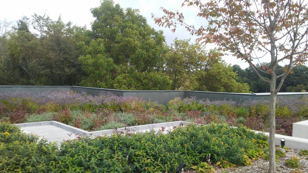
Cities across the nation face severe challenges that pose a risk to the health of communities and their rivers. Unlike natural environments, the vast quantity of asphalt surfaces found in urban areas prevents rainfall from infiltrating into the ground. In cities, rain always falls on hard surfaces like driveways, rooftops, parking lots, and streets, collecting contaminants and debris that flow into waterways. Creating green spaces within a city landscape allows rain easy access into the ground, decreasing the amount of stormwater runoff that enters our water sources.
Municipalities are addressing stormwater challenges through green infrastructure—a solution designed to capture and infiltrate rain the natural way. Green roofs, rain gardens, porous pavement and rain barrels are common green infrastructure solutions that reduce stormwater runoff and improve water quality in our urban rivers. Businesses creatively use green infrastructure to achieve multiple facility management goals and provide additional benefits to the community.
Despite the benefits nature-based solutions provide, businesses are often hesitant to invest in green infrastructure on their properties. Due to various perspectives on the value of the projects, managers may face difficulty in justifying the cost of implementation. Stormwater Currency (a partnership with American Rivers, Corona Environmental Consulting and Water Environment Federation) continues to collaborate with Grand Rapids, MI to implement market-based solutions that encourage businesses to incorporate green infrastructure practices. In this region, innovative leaders purposefully design nature-based solutions to achieve cost savings, efficiency goals and facility amenities while reducing stormwater runoff on their property.
Grand Rapids receives an average 36 inches of annual rainfall and twice as much snow; concerns surrounding flooding, bank erosion and high-water levels must be a priority. Known for its outdoor recreation, the city is highlighted by the Grand River meandering through downtown. The importance of restoring water quality in the river and protecting the health of the community is a shared concern for innovative leaders across the city. Among the sustainable trailblazers, Frederik Meijer Gardens & Sculpture Park and John Ball Zoo illustrate the values of nature-based solutions by providing business strategies, guest experiences and community amenities without harming the Grand River.
Meijer Gardens implements green infrastructure to protect biodiversity and improve water quality while still addressing the needs of growing tourism. Integrating sustainable practices in the 158-acre park has restored the wetlands and biodiversity on the property. The park manages stormwater by integrating water re-use for irrigation and tree canopies for shade. A one-of-a-kind sculpture roof garden features permeable walkways and planted trees among diverse vegetation overlooking a scenic oasis.
John Ball Zoo’s approach reduces stormwater runoff sustainably by adding natural elements on the 103-acre property for habitats and guest. Green rooftops replaced gravel to keep animals cool and deliver accessible walkways in natural settings. Utilizing in-house staff to implement many of the green roofs reduced costs while providing facility employees with education and training for future maintenance. Garden walls appear along pathways lined of fine wood ash to provide natural spaces for guests and water quality improvements for the Grand River.
Designing natural elements into our cityscapes will help improve our urban waterways and protect the health of our communities. Businesses committed to sustainability realize the value of nature-based solutions by savings in energy cost, irrigation, landscaping and facility maintenance while increasing flood protections and improving local waterways. Our featured businesses protect natural habitats, provide amenities to guests and facilitate educational opportunities to the community through green infrastructure solutions. Progressive approaches to improve our rivers will require imaginative solutions that address environmental, economic and social needs. Business leaders in Grand Rapids demonstrate that the intentional placement of nature-based solutions can generate benefits to a business that exceed the cost of reducing stormwater alone.
At American Rivers, we go about our work with an optimistic, can-do spirit. Clean water, healthy rivers, and thriving communities are our watchwords. We are happy warriors for rivers and streams, and we celebrate – rightly so – the successes and highlight the progress that our members, supporters and staff make possible. But when alarm bells sound warning us of the crisis just under the surface of the world’s rivers and streams, we’re reminded of the enormity of the task we face.
On February 19, the journal BioScience published “Bending the Curve of Freshwater Biodiversity Loss: An Emergency Recovery Plan.” Written by over 20 leading freshwater scientists and policy experts, the piece reviews the relentless pressure on global freshwater biodiversity. Though covering less than 1% of the planet’s surface, rivers, lakes and wetlands are home to a hugely disproportionate 10% of all species and one-third of all vertebrates, 70 mammal species such as otters and beavers, 250 types of turtles, and almost 18,000 fish species among them. As spectacular as the diversity of life in rivers and lakes is, the recent decline is equally dramatic. Though the loss of forests globally gets most of the headlines, studies show that wetlands are disappearing at a rate three times faster. Rivers around the world continue to be dammed, drained and polluted. The result? Freshwater vertebrate species (the fish and critters you’re most likely to be familiar with) are disappearing at twice the rate of their dryland and ocean counterparts. “Freshwater megafauna” – the biggest fish, the largest animals – have declined a staggering 88% since 1970.
Fortunately, amidst the bad news is something that should encourage American Rivers and its supporters. The authors of the BioScience article outline an ambitious “emergency recovery plan” to reverse these trends. The plan calls for global action to:
• Accelerate implementation of environmental flows
• Improve water quality to sustain aquatic life
• Protect and restore critical habitats
• Manage exploitation of species and riverine aggregates
• Prevent and control non-native species invasions in freshwater habitats
• Safeguard and restore freshwater connectivity
Peeples/USFWS
Here at home, American Rivers is already hard at work on many of these fronts, conserving environmental flows, fighting rollbacks to Clean Water Act regulations and improving management of polluted stormwater to better water quality in rivers and streams, restoring critical habitats in headwater streams and floodplains, and restoring freshwater connectivity with dam removals, culvert replacements, and levee breaches and setbacks. But much, much more needs to be done to halt the degradation of freshwater biodiversity. So American Rivers not only works to protect environmental flows; we partner with diverse stakeholders to develop and implement integrated water resources management initiatives to secure environmental flows across whole river basins. We don’t just do green stormwater management projects; we work to revolutionize how stormwater is managed in cities across the country. We secure protection for wild, unspoiled river habitats in the U.S. and export our ideas and experiences to river activists all over the world. We remove dams, and we provide the training, technical know-how and policy and fundraising support so others can do so as well. American Rivers tries to build this multiplier effect into everything we do. Because we can’t do this alone, but we believe we can do it together.
The fight to conserve global freshwater biodiversity has so far been a losing one. The Bioscience article is clarion call to step up the effort before it’s too late. American Rivers is proud to answer.
This blog was written by Gail Lazarus and Peter Raabe.
Can we have a free-flowing river AND a reliable water supply?
Heavier rains, more drought, growing populations, outdated dams, ageing water supply systems.
These are the facts of life across the Carolinas and in Southern Appalachia. American Rivers is working with community partners to rethink clean, reliable waters. We’re reconnecting some of the critical river systems in the region, including the Cape Fear River, the Neuse River, the Watauga River and the Tuckasegee River. We’re working to allow our rivers to adapt as the climate changes. We’re rethinking and planning with communities to build a stronger, cleaner water supply.
Our successes coordinating with local and national partners are yielding significant ecological and habitat benefits.
Sometimes it is easy. Dams disrupt the natural functions of the rivers that communities depend on. These barriers stop fish and other aquatic organisms from accessing their habitat, pose a public safety hazard, increase the threat of upstream flooding, and block recreational economic growth opportunities. Often, the original purpose of the dam has disappeared. Or, the dam needs so many expensive repairs that it is no longer cost effective to maintain its function. As we’ve seen in the Pee Dee River basin and the Congaree River basin, these obsolete dams provide a perfect opportunity to reconnect the flow of the river to the benefit of the community and the wildlife.
Sometimes, the solution needs some creativity. Ensuring reliable clean water supplies from our rivers and streams has been a strategy since the dawn of society. Historically, people built dams to create pools of water so that they could pipe water out of the pool. In many cases these water supplies are now in jeopardy as the dam ages. The question arises- can we remove the dam to restore the river and sustain the reliable water supply? American Rivers is working with communities along the Cape Fear River and the Tuckasegee River in the Carolinas to solve this question
Often, the solution requires big-picture thinking: Our priority is ensuring reliable clean water supplies for people and nature through all our work. It is a balance and area where we are pulling our communities of practice together to solve this problem. Can we use less water? On the Cape Fear River, American Rivers is working with communities to develop strategies- like greater water efficiency and eliminating wasted water- that ensure reliable water supply and adapt to the extreme droughts associated with climate change. Can we restore natural stream function and resiliency? Our team has also been developing and putting in place policies that restore water to streams through more natural releases from large dams and work with large dam operators to adjust releases for multiple purposes- from recreation to species protection. The collaboration between our experts on clean water supplies and river restoration allows for a more holistic approach to managing our river systems that creates the opportunity to have the long-term reliable water supply and a free-flowing restored river.
*I would like to receive updates from American Rivers.
Dams will still be necessary in many cases but innovations in engineering and architecture and improved water system management have created opportunities for the same water supply reliability without the ecological harm, liability, and maintenance costs associated with impoundments.
So, the answer is a resounding YES, free-flowing rivers can coexist with a reliable water supply. Thinking big picture about dams, water supply and water use create win-win situations for our communities in the Carolinas and the Southern Appalachians.
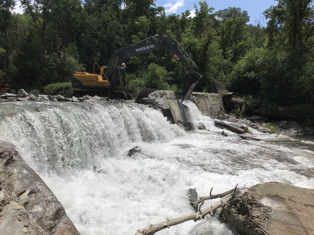
90 dams removed in 2019.
26 states (A RECORD!) removed dams in 2019.
973+ upstream river miles reconnected in 2019 through dam removal projects.
More states are getting involved in restoring rivers through dam removal, and it is wonderful to see. Private citizens and companies, municipalities, organizations, state and federal agencies are getting engaged in restoring river health across the country.
*I would like to receive updates from American Rivers.
The top four states removing outdated dams in 2019 were:
- California – 23 dams removed
- Pennsylvania – 14 dams removed
- New Hampshire and Vermont– 6 dams removed
How do we know all of this? Well, American Rivers is the only organization maintaining a record of dam removals in the United States. The database (here) includes information on 1,722 dams that have been removed across the country since 1912. Most of those dams (1,476) were removed in the past 30 years. If you’re more of a map person, you can see the removals mapped here. American Rivers played a role in nine of the dam removals on this year’s list. The database includes all known dam removals, regardless of the extent of American Rivers’ involvement.
Check out Jones River, MA before and after the removal of Elm Street Dam:
Photos by Jimmy Powell, Jones River Watershed
There are some great projects on this year’s list. Did you read earlier in the year about the Congaree Creek Dam removal in South Carolina? Or perhaps you heard about the great work over the past few years in California’s Cleveland National Forest? We have new stories posted about dam removals in Pennsylvania and Vermont as well. Some other highlights can be found below.
New River Restoration Resource Center
WE HAVE MORE BIG NEWS!! American Rivers is proud to share our newly revamped River Restoration Tools and Resources website! We invite you to go check out all of the great information that we have provided about river restoration, plus we share success stories, photos, videos, and more. We are hopeful that this new resource center will provide restoration practitioners, as well as the general public, connections to tools to help improve their work. After you check it out, let us know what you think in the comments below!
Highlights from Dams Removed in 2019
Howle and Turner Dam, Tallapoosa River, Alabama
The removal of Howle and Turner Dam was in the works for over four years. This project was the result of a great partnership between the U.S. Fish and Wildlife Service’s Partners for Fish and Wildlife program and the Alabama Rivers and Streams Network. The Service coordinated the pre-restoration planning and worked with their Fisheries and Aquatic Conservation Aquatic Habitat Restoration Team to carry out the demolition and restoration of the river channel. The 16-foot high by 100-foot wide concrete and steel dam was located on the Tallapoosa River, one of Alabama’s major rivers. The dam was originally built in 1935 to power a grist mill and cotton gin, but outlived its original purpose. The dam held historical significance to the locals of east Alabama, as it was a rural center of commerce for over half a century. In June 2019, Howle and Turner was removed to improve water quality and create habitat for rare mussel species such as fine-lined pocketbook and delicate spike.
Contact: Eric Spadgenske, U.S. Fish and Wildlife Service, 251-441-5872, eric_spadgenske@fws.gov
Saccarappa Dams 1 and 2, Presumpscot River, Maine
This project included the removal of two separate adjacent dams on the Presumpscot River, both originally built in 1911 for hydroelectric power— the Saccarappa Dam 1 (12-foot tall by 239-foot long) and the Saccarappa Dam 2 (12-foot tall by 154-foot long). The goals of this project were the restoration of fish passage and productivity of fish populations, as well as improvements in the downtown area through expansion of the “River Walk.” Restoring the productivity of the fish populations in the Presumpscot is vital not just for those who fish along the river, but also for the health of the fishing industry in Casco Bay and the Gulf of Maine. Migratory fish found in the Presumpscot, like alewives and bluebacks, are critical bait for the lobster fishery and key to the entire food system. The removal of these dams also opens up the longest and cleanest stretch of riverway in the most densely populated area of the state for the first time in two centuries and will greatly enhance the economic and recreational value of the river.
Contact: Barry Stemm, Sappi North America, 207-856-4584, barry.stemm@sappi.com
Jordan’s Point Dam, Maury River, Virginia
Jordan’s Point Dam (10-foot high by 180-foot wide) was a historical, concrete dam built in 1911 and located in Lexington, VA. Prior to deconstruction, it was structurally compromised with many cracks, and had outlived its purpose of powering various mill operations. When the dam was first breached and the water level lowered during its removal, another timber crib dam was revealed and subsequently removed. This project improved riverine ecology, hydrology and habitat restoration along 1.2 miles of Maury River upstream. Additionally, the project removed a significant safety hazard and was expected to greatly benefit recreation and river usage along City Park. The dam had been a safety concern for the community since 2006, when a teenager drowned going over the dam into the hydraulic current.
Contact: Louise Finger, VA Department of Game and Inland Fisheries, 540-248-9378, louise.finger@dgif.virginia.gov
This past year was a great year for dam removal, and we hope that 2020 can beat it! We are continuing to build momentum across the U.S. for removing unsafe, unnecessary, and outdated dams. Keep an eye out for more information on our efforts to scale up river restoration over the coming months!
The removal of the two Scotland Pond dams on Conococheague Creek is one of many major infrastructural upgrades Greene Township, Franklin County, PA, is adding to improve their township for locals and visitors alike.
In Fall 2019, two dams functioning as one on Conococheague Creek were removed by Greene Township in Pennsylvania in collaboration with American Rivers, the Pennsylvania Fish & Boat Commission (PFBC), Scotland Campus, Inc. (SCI), ECS Mid-Atlantic (lead engineer) and RiverLogic (construction firm).
*I would like to receive updates from American Rivers.
Prior to the 18-day long deconstruction, the two dams sat adjacent to one another on either side of a small river island on Conococheague Creek. Approximately 1,000 feet of the creek has now been restored and supports more biodiverse habitats, aquatic wildlife and natural transport of rich sediments downstream for the breeding grounds of native aquatic organisms.
Like many other dams, the Scotland Pond dams had far outlived their original purpose. They had become deteriorated and posed a risk to public safety in addition to their negative ecological impacts and the financial burden of maintenance.
Greene Township (the Township), Franklin County, home to more than 16,000 residents and located within the Chambersburg designated “Micropolitan” Area, is currently experiencing a municipal renaissance. Over the last several years, the Township has worked diligently to promote, develop, and plan for infrastructure and recreational improvements in the community – projects that will ultimately have a significant impact on how residents and visitors spend their leisure and travel time in the area. Upon completion of the improvements, a significant revitalization in the targeted Scotland community will be realized. Scotland is home to the Greene Township Municipal Park, Corker Hill Barn and Homestead, Scotland Campus, Inc. (SCI) and will eventually contain a portion of the proposed Conococheague Trail. In addition, the Conococheague Creek runs through several Franklin County municipalities, including the Village of Scotland.
So far, four other dams (Birch Run Reservoir, Siloam Dam, Wilson College Dam and Wolf Lake Dam) have been removed from the Conococheague Creek, leaving just one more remaining dam that is known of. If that final dam is removed, the 57 miles of its 80 mile stretch in Pennsylvania would flow completely freely and uninterrupted.
The decision to remove the Scotland Pond dams allowed Greene Township to move forward with projects to add impactful recreational opportunities, such as the creation of a water trail along the creek and a kayak/canoe launch. Greene Township now benefits from beautiful, healthy waterways the local people and visitors can enjoy and will hopefully inspire others to take the same initiatives in their communities. This is a notable model project for any municipalities considering removing an outdated dam.
This project received financial support from American Rivers through a subgrant from the National Fish and Wildlife Foundation, as well as the Pennsylvania Department of Community and Economic Development, Commonwealth Financing Authority Watershed Restoration and Protection Program Grant.
Special thank you to American Rivers intern, Hannah Piatak, for her contributions to this blog and her help compiling our annual list of 2019 dam removals. Check out our updated map and database of dam removals here. Additional gratitude to Greene Township for their contribution to this blog.
The following is a guest blog from our partners in river restoration at the White River Partnership. The White River is significant for being one of the last free-flowing rivers in the State of Vermont and is the longest un-dammed tributary to the Connecticut River.
In August 2019, trout navigated upstream through the White River’s “First Branch Falls” in Royalton, Vermont, for the first time in 250 years.
Since 1776, the Lower Eaton Dam sat atop the Falls, built to provide power to Royalton’s first industrial site. Inactive since the late 1960s, the dam was in disrepair–threatening the safety of local residents recreating in the deep pool below the Falls and the mill pond upstream–and a total barrier to fish passage.
*I would like to receive updates from American Rivers.
During the summer of 2019, the local watershed group, White River Partnership (WRP), led a collaborative effort to remove both the Lower Eaton Dam and a second dam owned by the same couple. Located 350 feet upstream of the lower dam, the Upper Eaton Dam had been inactive since 1927.
Lower Eaton Dam Removal.
Ultimately, the pair of dam removals reconnected 30 miles of cold-water habitat for the benefit of wild brook, rainbow, and brown trout as well as American eel and sea lamprey populations.
The WRP has partnered with a diverse group of local, state, and federal partners–including American Rivers, U.S. Fish and Wildlife Service, and many others–to remove four dams since 2016. Only four intact dams remain on major branches of the White River, which is the longest undammed tributary to the Connecticut River.
Coming Soon… In 2018, the WRP worked with partners to remove the Killooleet Dam remnants on the Hancock Branch of the White River. Currently, WRP is working with a local engineer to design dam removal projects for three additional dams: one on the Second Branch and two on the First Branch of the White River. In sum these projects will restore 180 miles of the White River to free-flowing conditions!
The White River Partnership’s work exemplifies the benefits of working on river restoration on a watershed scale. These removals, and 88 others from 2019, are highlighted in our new dam removal map and database release. Check it out here.

Mary Russ is the Executive Director of the White River Partnership (WRP). The WRP envisions a White River watershed in which individuals and communities work together to make informed decisions that protect and improve water quality, fish and wildlife habitat, flood resilience, and recreational river access.
When Trump administration Interior Secretary David Bernhardt, a former oil and gas industry lobbyist, celebrates a proposed regulation as “really, really big…affect[ing] virtually every single decision by the federal government that affects the environment,” folks who care about clean air and water had better brace for some bad news. The proposed rule, drastically changing the way federal agencies implement the National Environmental Policy Act (NEPA), is very bad indeed.
NEPA was enacted in 1969, among the first wave of environmental legislation passed in the late sixties and early seventies – the Wild and Scenic Rivers Act in 1968, the Clean Air Act in 1970, the Clean Water Act in 1972, the Endangered Species Act in 1973 – in an attempt to reverse the degradation of the nation’s air, water, and natural resources. It is the cornerstone federal environmental law, requiring that any major action undertaken, permitted or funded by the federal government be assessed to determine its impact on our air, land and waters. Federal agencies are required to prepare environmental assessments and, if necessary, more detailed environmental impact statements (EIS) that evaluate the impact of the proposed project, consider alternatives that would have lesser impacts and, perhaps most importantly, open the process to public scrutiny and comment.
Norman, flight by LightHawk
NEPA is based on the common-sense notion of “look before you leap,” that we should know the impacts that federal actions such as constructing highways, pipelines, dams, power plants, transmission lines and other projects will have on the nation’s land, air, and water before we build them. The law provides opportunities for communities and individuals to learn about projects affecting their neighborhoods, evaluate the impacts of the project as described in the EIS, and make their voices heard through the public comment process. Over the last 50 years, thousands of projects that would have wreaked untold damage on the environment have been modified or even stopped after NEPA review.
The Trump administration’s proposals to undermine the law, on the other hand, defy common sense. Lowlights include:
- Redefining “major federal action” to eliminate NEPA review of a large swath of federal activity;
- Ending requirements to consider the cumulative impacts of multiple projects;
- Inviting private sector project proponents to prepare their own environmental reviews (Fox, welcome to the chicken coop!);
- Allowing federal agencies to completely ignore climate change(!) when evaluating projects; and
- Severely curtailing public participation, tearing out the very heart of the Act.
Fortunately, our voices haven’t been silenced yet. You can help stop the Trump administration from kneecapping NEPA by taking action here. Time is short, so act now! The deadline to submit comments on the proposed rule is March 10, 2020.
SPONSORED BY CASCADE BLONDE
It’s the end of a decade and another year of New Year’s resolutions. Many of us will vow to take on healthy resolutions like drinking more water, but as with any resolution, it’s not that simple.
In fact, the majority of our water supply comes from rivers and streams. If all the world’s water were to fit in a gallon jug, only a tablespoon of it would be the equivalent of the fresh water available to us to drink.
To help preserve America’s waterways with an eco-resolution (and still continue to have access to clean drinking water), American Rivers’ National River Cleanup® program has partnered with Cascade Blonde American Whiskey to share five easy ways to be more river friendly in 2020.
1. Refuse extra plastic. Or, choose one single-use plastic item and make a commitment that you will no longer use it.
Tell the clerk you don’t need a grocery bag for that Chapstick. Purchase a reusable stainless-steel straw and keep it in your bag or car for on-the-go sipping. Say “No thanks!” to free plastic utensils when ordering takeout.
2. Raise money for a good cause… like healthy rivers and clean water.
Start an online fundraiser for American Rivers to celebrate your birthday or other life event.
3. Exercise + volunteer, more. Yes, you can do both at the same time!
Volunteer for a National River Cleanup® as a great way to get steps into your day and get litter out of your local waterway. Join American Rivers and Cascade Blonde at a river cleanup in 2020. Follow @CascadeBlonde on Instagram for event details or sign up for a river cleanup near you.
4. Get outside!
There are thousands of miles of riverside trails in U.S. cities and towns (1,500 miles in refuges). Or take advantage of holidays — like Presidents’ Day on February 17, 2020 — at national and state parks.
5. Join Cascade Blonde American Whiskey in making America’s waterways cleaner.
Pledge to pick up 25 pieces of trash in 25 days. Organize your own river cleanup. And spread the river love by posting a picture on Twitter or Facebook of yourself picking up trash. Tag #rivercleanup and your photo will show up in our virtual landfill.
Good luck with your resolutions and happy New Year from all of us at American Rivers and Cascade Blonde American Whiskey!

Cascade Blonde American Whiskey proudly supports American Rivers in the fight to protect and restore our nation’s rivers. The company has sponsored National River Cleanup® since 2018 to celebrate clean water and provide opportunities for people to help keep the waters they enjoy healthy.
Learn more about Cascade Blonde American Whiskey by visiting www.cascadeblonde.com.
Communities across coastal South Carolina will benefit from land protections pioneered by the Waccamaw National Wildlife Refuge (WNWR) and its partners. Over the years, a warming climate, sea level rise and rapid development has posed a growing threat to wildlife in and around the Refuge. Faced with the need to provide additional habitat for animals and plants to thrive coupled with federal restrictions on expanding the Refuge, WNWR Manager, Craig Sasser, used an innovative approach. Working with a team of service staff and key partners, Sasser developed a ground-breaking proposal that allowed lands within the existing Refuge boundary that are unlikely to become federally protected to be exchanged for those in surrounding forests that can play a key role in improving the resilience of wildlife and communities along the Waccamaw River.
Using a collaborative process called a Landscape Conservation Design, Sasser worked with American Rivers, The Nature Conservancy and The Friends of Coastal South Carolina to look into every possible option for obtaining critical habitat without expanding the refuge boundary. After years of careful planning, an Environmental Assessment and Land Protection Plan for the pilot boundary modification program was released for public review and received numerous supporting comments. Sasser and Refuge partners’ hard work paid off in October 2019 when the boundary modification was approved by US Fish and Wildlife Regional Director, Leopoldo Miranda.
The Waccamaw National Wildlife Refuge is the first refuge in the country to successfully use minor boundary modification as an approach to conserve land and build climate resilience. “We could have never accomplished this monumental effort without the support and collaboration of so many partners” said Sasser.
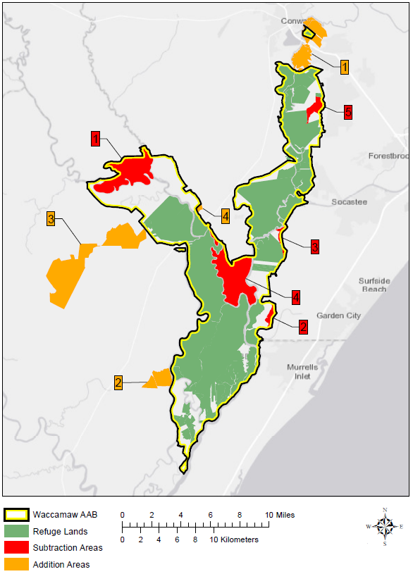
The minor boundary modification will remove 6,849 acres of land from the Refuge which is either unlikely to be protected by the Refuge or no longer provides quality wildlife habitat due to local activities that have permanently changed the landscape. These areas are shown in red on the map. The current boundary will be changed so that 6,638 new acres, shown in yellow, will be added to the Refuge through the purchase of properties from willing landowners. These additional lands harbor critical riverside habitat that will help local wildlife withstand the effects of climate change, improve public access to the Waccamaw River, enhance recreational opportunities, support clean drinking water and reduce flood risks in surround communities.
“We applaud the Waccamaw National Wildlife Refuge for its leadership,” said Gerrit Jӧbsis with American Rivers. “Communities will benefit from the refuge’s vision as protected lands continue to ensure clean drinking water, safeguards against flood damage, and public access to some of the Lowcountry’s most treasured landscapes.”
The Waccamaw National Wildlife Refuge allows countless photographers, kayakers, fishers, and hikers, educators and their students, history enthusiasts, birders, and naturalists to enjoy the Waccamaw River. American Rivers and our partners have been at the forefront of efforts to promote all of the benefits the river provides to both people and nature by supporting the Refuge and encouraging local residents to enjoy and protect the Waccamaw River Blue Trail.
The Waccamaw River is a lifeline for North Carolina and South Carolina. It is critical to the region’s economy, environment, lifestyle, and health of local communities. It also serves as a major source of the region’s drinking water. With a changing climate, growing population, and competing needs for water, protecting the Waccamaw and its surrounding lands is more important than ever. The minor boundary modification will improve the resilience of local wildlife, provide additional opportunities for recreation for residents and visitors, and safeguard the well being of local communities.