This is a guest blog by David Stokes, Executive Director of Great Rivers Habitat Alliance.
Due to the immense flooding the upper Midwest experienced in 2019, and because of decades of floodplain development and poor river management, the Upper Mississippi River and the Lower Missouri River hold the top two spots among America’s Most Endangered Rivers® of 2020. Both are endangered for the same reason: Climate change is exacerbating years of bad decisions along these vital waterways, leading to more flood devastation throughout the Midwest.
As if on cue, the City of St. Charles, Missouri — a suburb of St. Louis — has apparently decided to do American Rivers one better and tell local and national river advocates: You thought the choices others have made in the past were bad? Wait until you see what we plan to do!
St. Charles is moving ahead with not one, not two, but three different flood control and development projects within the city — two along the Missouri River and one along the Mississippi River. Each one of these projects is dreadful in their own way. Combined they will be a disaster for the greater St. Louis region. Increased flood frequency, height and severity is a fact in and around St. Louis. The causes of this trifecta are too much floodplain development, too many levees and climate change.
Consider this scenario: City A needs more tax revenue. So it decides to develop its available land, which happens to be in the floodplain of the Mississippi River. It builds a levee, paves over the land and builds a new shopping center or similar development. Water levels rise.
Adjacent City B has the same flat, relatively cheap, undeveloped floodplain land. It sees City A’s new tax collections and says, “Hey, we can do that!” It repeats the cycle itself. Each city only benefits if the new development is within its city limits. In order to guarantee that and outweigh other factors that might lead businesses to locate nearby but outside city limits, generous local tax subsidies are instituted. Some of the businesses in City A are lured to City B, reducing the economic benefits to City A, while maintaining the environmental damage.
Cities C, D and E look at what A and B did and imitate it. Every new floodplain project and development increases the flood severity, making older levees and other flood control measures less effective — and reduces the amount of floodplains available to store and convey water. Every project also reduces the tax base through routine use of tax subsidies. Finally, because the cities primarily seek sales taxes, they focus in most instances on retail sales for their floodplain projects. Retail sales are not a driver of long-term economic growth.
So, in the end, we have increased flooding, a reduced tax base, no regional economic growth, and environmental and habitat destruction. This is, of course, precisely what has happened in the St. Louis region over the past several decades.
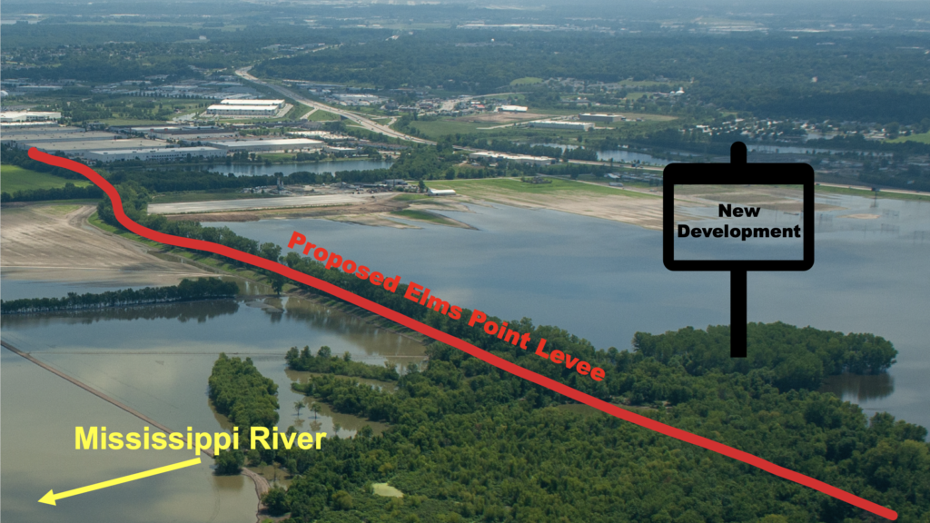
But back to St. Charles. The city plans one major riverfront development, Riverpointe, along its beautiful Bangert Island park, and two new levee projects, the Frenchtown and Elm Point levees.
The Riverpointe development plans to create a substantial pond between the existing Bangert Island park and the new development. In normal water conditions, the park is connected to the mainland, but the new basin will separate the island from the new development. In order to keep everything technically legal, the fill used to raise the land out of the floodplain for the project will come from building the basin. This gives the engineers and the city the ability to claim flooding will not be made worse. However, future floodwaters will no longer slowly rise up a sloping hill, but will hit against an earthen wall and send the floodwaters to harm someone else. Bangert Island, itself, will almost certainly sustain increased damage during future floods from these plans.
The new levees will likely be ever more harmful. If the city follows through on their proposals and builds two 500-year levees, the amount of water that would be sent to flood someone else with the next major flood would be enormous. The two enlarged and expanded levees would significantly increase flooding for property owners upstream and across from the levees. While the city will build these levees under the guise of “protecting” people, the primary reason is to allow for increased development behind the new levees. Once again, the pursuit of future municipal tax dollars is the primary driver of river policy in the St. Louis region.
With these actions, the city of St. Charles is following in the footsteps of many other St. Louis suburbs who have demonstrated time and again that they do not care about flood safety, long-term economic development or regional thinking. These three proposals and so many before them are done for short-term benefits without any thoughts or concerns about the long-term harms. The city of St. Charles is doing all it can to make sure the Upper Mississippi and Lower Missouri rivers stay on the top of the America’s Most Endangered Rivers® list in 2021 and beyond.
Read more about the levee proposals here:
https://www.riverpointe-stc.com/
https://www.stcharlescitymo.gov/936/Frenchtown-Elm-Point-Levee-Studies

David Stokes is a Saint Louis native and a graduate of Fairfield (Conn.) University. Stokes has been the executive director of Great Rivers Habitat Alliance (GRHA) since 2016. He focuses his efforts on preserving the Confluence floodplain of the Mississippi, Missouri, and Illinois rivers from harmful development. Prior to joining GRHA, he was an assistant to Saint Louis County Councilman Kurt Odenwald from 2001 through 2006. Stokes was a policy analyst at the Show-Me Institute from 2007 to 2016. He currently serves on the University City Commission for Access and Local Original Programming (CALOP) and is a past president of the University City Library Board. Stokes was the 2012 representative to the Electoral College from Missouri’s First Congressional District. He lives in University City, Missouri with his wife and their three children.