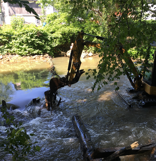
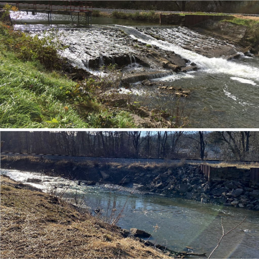
If you know baseball, you are probably familiar with the strategy of “batting cleanup.” For those less acquainted with the sport, the cleanup hitter is a strong player who bats when the bases are loaded, creating the opportunity for several runs to be scored on one hit. American Rivers has been the cleanup hitter in the West Branch Susquehanna River headwaters, with three dam removals recently completed that reconnect 63 miles of aquatic habitat.
The West Branch Susquehanna headwaters were once effectively devoid of aquatic life due to the discharge of acid mine drainage from more than a century of widespread coal mining that fueled the Industrial Revolution. They’ve since been revived thanks to our partners’ significant and effective water quality investments. American Rivers’ recent investment in aquatic connectivity has reconnected these healthy waterways for wild brook trout and other river resident species, including Pennsylvania’s official amphibian, the Eastern Hellbender.
The West Branch Susquehanna springs from near the village of Bakerton in Cambria County and flow due north for about 30 miles until it confluences with Chest Creek at Mahaffey. There it shifts to a northeasterly path across Pennsylvania’s Appalachian Plateau and gradually arcs south to join the Susquehanna River near Sunbury. The West Branch and its tributaries are the historical range for species such as trout, shad, herring American eel, and freshwater mussels, whose lifecycle is intertwined with these fish.
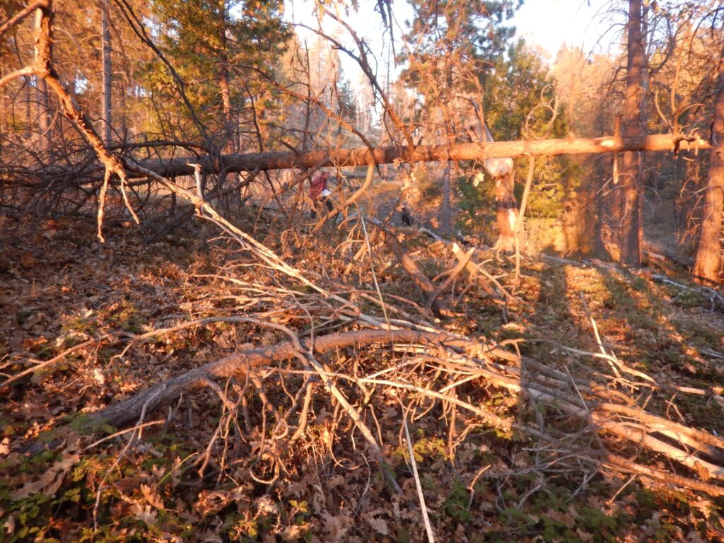
| Photo by Lisa Hollingsworth-Segedy
In the early 2000s, Cambria County Conservation District, Trout Unlimited, and the West Branch Susquehanna Restoration Coalition invested heavily in reversing the impacts of abandoned mine drainage in the watershed. Active and passive mine treatment systems, along with coal refuse cleanups totaling more than $30 million, have spurred a remarkable water-quality rebound in the headwaters. The Conservation District also completed award-winning habitat enhancements in the leveed section of Chest Creek through Patton to support trout accessing this reach of altered waterway.
Because American Rivers had prioritized dam removal projects in watersheds with abandoned mine drainage-treatment successes, the Upper West Branch Susquehanna and Chest Creek rose to the top of our project selection process.
In 2015, we identified two obsolete dams on Chest Creek as restoration targets, followed by a third unknown, unpermitted dam on the mainstem West Form in 2017. Eckenrode Mills Dam was removed in 2017 with both Garmantown Mill and Patton Dams removed in 2019. American Rivers owes project success to the steadfast assistance of numerous partners, including Cambria County Conservation District, Trout Unlimited, PA Fish & Boat Commission, Chest Creek Watershed Alliance, PRIDE of Cambria County North, and multiple landowners.
Hollingsworth-Segedy
Anecdotal information from local anglers shows that wild trout are already accessing the newly-reconnected stream reaches, and hellbender are becoming more plentiful as well. We anticipate that upcoming fish surveys will confirm these early findings. American Rivers will be returning to the site of the former Patton Dam in 2020 and 2021 to restore a riparian wetland that was previously drowned by the impoundment behind the dam. This effort will improve habitat and water quality while reducing the impacts of local flooding. Local partners are now working to expand water and land recreation trails in the watershed, to provide additional aquatic habitat improvements in Chest Creek, and to promote the Upper West Branch Susquehanna River and Chest Creek as outdoor recreation destinations.
Our “batting cleanup” approach to dam removal in the Upper West Branch Susquehanna watershed has proven that once water quality impacts are addressed, habitat reconnection will return fish to their historic range. We will continue this model approach for river restoration in other watersheds, and continue building partnerships that build on the benefits of free-flowing rivers.
American Rivers was founded nearly 50 years ago, in 1973, to fight construction of new dams and protect our nation’s remaining wild, free-flowing rivers. We have carried on those fights ever since – and we have expanded our focus. American Rivers has been instrumental in sparking a national, and now global, movement to restore rivers by removing dams. And for decades, we have worked with the hydropower industry to reform how dams are operated in order to minimize their harmful impacts.
For the past two and a half years, American Rivers has participated in the Uncommon Dialogue, convened by the Woods Institute at Stanford University. The dialogue brought together representatives of the hydropower industry and the conservation community to find common ground on the role of hydropower in addressing climate change while also restoring free-flowing rivers.
We’re at a pivotal moment and it is critical that we find solutions. Hydropower dams have devastated river health nationwide, with significant negative impacts on rivers, fish and wildlife populations, and cultural resources. There are also serious safety issues with dams, as evidenced by the failure of Michigan’s Edenville Dam in May. At the same time, climate change is threatening life as we know it on our planet. We must be proactive in ensuring a mix of energy sources that don’t rely on dirty fossil fuels – and that includes hydropower.
Recently, participants in the dialogue agreed on a Joint Statement of Collaboration in which the parties agree to continue to work together to make progress in seven areas:
1. Accelerate Development of Hydropower Technologies and Practices to Improve Generation Efficiency, Environmental Performance, and Solar and Wind Integration
2. Advocate for Improved U.S. Dam Safety
3. Increase Basin-Scale Decision-Making and Access to River-Related Data
4. Improve the Measurement, Valuation of and Compensation for Hydropower Flexibility and Reliability Services and Support for Enhanced Environmental Performance
5. Advance Effective River Restoration through Improved Off-Site Mitigation Strategies
6. Improve Federal Hydropower Licensing, Relicensing, and License Surrender Processes
7. Advocate for Increased Funding for U.S. Dam Rehabilitation, Retrofits and Removals
In addition to American Rivers, parties to the Joint Statement include American Whitewater, Hydropower Reform Coalition, and National Hydropower Association.
In agreeing to the Joint Statement of Collaboration, American Rivers recognizes that hydropower can be part of the solution to climate change. At the same time, the hydropower industry is recognizing that the time is ripe for removal of obsolete and unsafe dams which restores free-flowing rivers.
The Joint Statement of Collaboration does not mean that American Rivers and the hydropower industry will see eye to eye on everything. American Rivers is fighting efforts supported by the hydropower industry to weaken Clean Water Act protections for rivers. We are working with tribes and conservation partners to ensure that Pacificorp lives up to its commitments to remove four dams on the Klamath River in California and Oregon and install fish passage improvements on another dam it operates on the Lewis River in Washington. By signing the Joint Statement of Collaboration though, American Rivers hopes that such conflicts will become less frequent as we build greater trust. American Rivers is continuing our role as pragmatic problem-solvers, seeking some common ground with the hydropower industry where it will advance our goal of removing obsolete and unsafe dams to restore healthy, free-flowing rivers and employing every tool available to fight the existential threat of climate change.
Even in turbulent times, rivers are a constant.
Their clean, free-flowing waters nourish our bodies, spirits and communities. Their lush habitats safeguard birds, fish and wildlife. They connect us to our history, to our future, to each other.
Today, we celebrate our nation’s Wild and Scenic Rivers. Fifty-two years ago, President Lyndon B. Johnson signed into law the National Wild and Scenic Rivers Act, establishing a system of protection for rivers with outstanding values. A Wild and Scenic designation is the strongest protection a river can receive, and means the river is forever protected from dams or other harmful development.
Wild and Scenic Rivers are national treasures – rivers like the Upper Delaware, Middle Fork Salmon, Rogue, Rio Grande and Chattooga.
To honor the 50th anniversary of the Act in 2018, American Rivers and our partners set a goal to protect 5,000 new miles of Wild and Scenic Rivers and 1,000,000 acres of riverside lands, and to build a river conservation legacy. Thanks to you and supporters nationwide, we’re well on our way to victory – we’ve protected more than 1,800 miles of our 5,000 miles goal, and 500,000 acres of land.
The movement to keep our nation’s rivers free-flowing is growing, as well. Campaigns across the country are working to protect an additional 5,000 miles of rivers in states including North Carolina, Tennessee, Montana and Oregon.
Congressional champions including Senators Udall and Heinrich of New Mexico, Senator Wyden of Oregon, Senators Murray and Cantwell of Washington as well as U.S. Representatives Huffman and Kilmer are championing Wild and Scenic protections in Congress totaling over 1,300 miles. The Gila In New Mexico, the Owyhee in Oregon, portions the Trinity River watershed in California, and the rivers flowing off of the wild Olympics in Washington State would be protected under pending legislation.
But we have much more work to do – not only to protect clean water and healthy, free-flowing rivers, but to demand safe, equitable access to rivers and the outdoors for all. To ensure communities of color can take the lead crafting river protection solutions that impact their futures. And to listen and learn from Indigenous leaders who have been stewards of our rivers since time immemorial.
Upon signing the Wild and Scenic Rivers Act on October 2, 1968, President Lyndon Johnson said, “Every individual and every family should get to know at least one river.”
Today, I hope you follow President Johnson’s advice and get out to enjoy a river near you, while wearing a mask and maintaining social distance of course to protect your family, friends and community.
Take a moment to appreciate all we’ve accomplished for Wild and Scenic Rivers, together. And join us as we embark on a new era of river protection, advancing a vision of clean water and healthy rivers everywhere, for everyone.
Change starts with small actions and when combined can have a big impact! This is where you come in. You can prevent trash from getting in the river and keep our waters clean and healthy for people and wildlife.
Trash is more than just an eyesore. It’s harmful to wildlife and contaminates rivers, which provide 60 percent of our drinking water. Any trash you see whether on the sidewalk or in a ditch is likely to end up in your local stream or river.
Here are 3 ways you can take action:
1. Join our virtual cleanup challenge with Litterati
Help us achieve our litter reduction goals using Litterati, a mobile app that allows user to photograph, upload and tag litter in their area. Participate in our challenge while you walk your dog, spend the day at the park, or while loading the groceries in your car. Together, we can capture and discard more pieces of litter.
2. Take the River Cleanup Pledge
Commit to picking up one piece of trash every day for one month.
3. Organize a small, private cleanup
This cleanup can happen anywhere at any time, it’s up to you. Register your event with us and we’ll ship you free trash bags.
Litter Collection Tips:
1. Go to a public space like a park, creek or trail in or near your neighborhood to find litter.
2. Carry a bag to collect the litter.
3. Practice social distancing of at least 6 feet between you and others not in your household.
4. Wear a face mask and gloves.
5. Only pick up trash that you’re comfortable collecting. Place sharp objects like broken glass in a solid container and safely dispose it in a trash bin.
6. Dispose litter on-site if available or at your house.
Oregon and California are having their worst wildfire seasons on record causing incredible devastation, tragic loss of life and measurable public health threats from smoke. Because of the most recent fires I have friends, family members, and colleagues who have lost their homes. As the fires still burn, we all must support grieving and dislocated communities and the firefighters risking their lives.
Living in Portland, my wife and two kids have luckily been spared the worst of the impacts, but like millions of people on the west coast have experienced days or weeks of toxics air quality advisories. According the monitor nearest to our house our air quality was literally off the charts, above the EPA’s “Hazardous” air quality category for three days. Because of health concerns for our young kids we left the city and headed to find clean air at the Oregon coast. Unfortunately with the effects of climate change, these events seem to be becoming routine.
Fire has always been a natural part of the landscape in the forests across our region, but we are now in a new era of “megafires.” On our National Forests, a century of forest fire suppression, the push to grow high densities of trees in large plantation-like mono-cultures, and especially, changing climatic conditions have led to drier and hotter weather patterns and created more combustible conditions. The larger and hotter forest fires that result can have significant impacts on forest health, rivers, water quality, and local communities.
In Oregon, the worst of the most recent fires occurred in the watersheds of some of the highest value rivers, the McKenzie, the Molalla and North Santiam that are designated as national Wild and Scenic Rivers. These rivers provide drinking water to communities downstream, provide habitat to abundant salmon and steelhead runs, and supports outstanding upland and instream recreation. Once the fires are out, these rivers are likely to look, very different and like the communities along their banks will need our help.
Thankfully Wild and Scenic River designations and associated river management plans allow for flexibility to prepare and fight fire for the benefit of people and the river itself. As communities work to protect their rivers as Wild and Scenic in Oregon and elsewhere, we must adopt up-to- date fire preparedness and wildfire fighting strategies into river management plans.
Julie Fair
Congress is weighing in as well and is already considering strategies to combat these kinds of fires on public lands. Senators Ron Wyden, Maria Cantwell and Joe Manchin have introduced a commonsense bill, the National Prescribed Burn Act of 2020, to expedite the use of prescribed burns that mimic natural processes to reduce fire risk before fires start—exactly the kind of scientifically sound and proactive approach we need that would help reduce risk and improve watershed health.
We should be wary of other proposals that are using wildfires as a way to blame federal land managers and repackage bad ideas simply to log more without environmental review which would harm rivers and not even reduce fire risk in areas that need it most, where wildlands and developed areas meet or wildland urban interface.
The science on the effects of logging on the fragile post-fire landscape clearly shows dramatic increases in the amount and duration of harmful sediment in streams and rivers compared to watersheds that are left alone to recover. Some simple rules can help reduce harm to water quality and salmon habitat. This includes staying away from streamside areas and staying off of steep slopes prone to soil erosion and landslides that once triggered can dump too much sediment into streams over an extended period of years. It is vitally important to avoid creating new roads and decommission any temporary roads that are often the largest contributor to harmful amounts of stream sediment.
As we craft responses to future wildfires that will inevitably occur, we must better integrate sound fire preparedness strategies into our existing conservation tools while staying committed to protecting the most valuable natural resources that come from our forests: clean drinking water, fish and wildlife habitat, and outdoor recreation.
Here in Oregon, the good news is that it’s started to rain.
From coast to coast, communities across the country are feeling the impacts of too much – or not enough water at the right time. Drought and record-breaking wildfires have plagued the West this summer. In the last month, over 5 million acres of land has burned in California, Washington and Oregon. These wildfires are uprooting communities, causing serious health issues and when the smoke finally clears, leftover debris and toxic runoff could pollute our rivers and impact drinking water supplies. Conversely, on the East Coast and the Midwest, significant flooding has occurred. This year we’ve seen 20 tropical storms, 6 of which have turned into hurricanes. Crashing into the coast, storm surges are causing catastrophic flooding and torrential rainstorms are impacting communities far beyond the coast. Along the Upper Mississippi, an unusual derecho covered hundreds of miles and brought significant rainfall and wind damage to the region.
While you can’t directly point the finger at climate change for any one weather event, scientists have found that climate change is increasing the frequency, intensity, and impacts of extreme weather events. On top of that, climate change is shifting where and when water is available. Precipitation is becoming more variable and uncertain, leading to more frequent and more intense floods and droughts. The impacts associated with a changing climate are exacerbating existing challenges facing our country. America’s rivers and water infrastructure have been neglected and abused for decades. Too many people in our country lack access to safe, clean affordable water — two thirds of which comes from rivers and streams. Centuries of poor river management has degraded ecosystems and disconnected communities from their rivers. As communities begin rebuilding, we must address longstanding social and environmental injustices, and ensure our communities and infrastructure are more resilient in the face of a changing climate.
Clean water infrastructure and healthy rivers are smart investments for communities across the country. They create stronger, more resilient communities and contribute significantly to local economic growth and job creation. The Value of Water Campaign estimated that every $1 million spent on water infrastructure in the United States generates more than 15 jobs throughout the economy. Similarly, the University of Oregon found that every $1 million invested in watershed restoration creates 16 new or sustained jobs on average. Healthy rivers also spur tourism and recreation, which many communities rely on for their livelihoods. The Outdoor Industry Association’s National Recreation Economy Report found that the outdoor watersports and fishing economy supports over 1.5 million jobs nationwide.
Earlier this summer, American Rivers released a new report, Rivers as Economic Engines: Investing in clean water, communities and our future detailing how the right investments in water infrastructure, natural infrastructure and river restoration can create jobs, strengthen communities and address longstanding injustices. While Congress has made some initial investments in healthy rivers and water infrastructure including the recently passed Great American Outdoors Act, more action is needed. We are calling on Congress to invest $500 billion over 10 years to create the transformational change we need when it comes to ensuring clean water and healthy rivers for everyone.
We have a historic opportunity to revitalize our communities, make our infrastructure more resilient, and ensure healthy rivers and clean water for everyone. Investing in water infrastructure and healthy rivers creates jobs and economic benefits, strengthens our communities, improves public health and safety, addresses longstanding injustices, and improves our environment.
Tell Congressional leadership that investing equitably in clean water infrastructure and healthy rivers is a top priority. Take action to support game-changing investment in water infrastructure and healthy rivers – and ensuring it goes to communities most in need.
September 18, 2020
The thunder and lightening woke me up. After ten days of wildfire lockdown in Portland, the rain this morning is a giant relief. Since the fires started in Oregon, the air quality has been terrible — “beyond hazardous” the index says — so the limited pandemic excursions to walk our dog, go to the park, ride bikes with my boys had stopped. Now, maybe, we can go outside again.
My family is fortunate. The fires have burned more than a million acres and ten people have died. Many in our river community — American Rivers partners, friends and supporters — have had to evacuate. Many across our state have lost homes. So many beloved rivers, forests and communities have been impacted — the Little North Santiam. North Umpqua. Clackamas. McKenzie. Rogue. Klamath.
I’ve been reading in the news about other devastating stories linked to climate change — the fires in Brazil, the birds dying in New Mexico, the hurricanes threatening the Atlantic and Gulf coasts. It’s easy to slip toward despair.
But I keep coming back to a quote by Dr. Ayana Elizabeth Johnson:
“Even though there is so much we can’t save, the other side of that is there is so much that we still can save. So, who are we to give up? What gives us the right to give up on the planet and each other? … It’s truth, courage and solutions. That’s what’s going to get us there.”
What can we save? We can start by saving a river.
I’m thinking about the Middle Fork Nooksack, where American Rivers and our partners just removed a dam. We set the river free, restoring habitat so we can bring back salmon runs — salmon that are vital to the Nooksack Indian Tribe and Lummi Nation, and desperately needed by starving Southern Resident Killer Whales. A new orca calf, J57, was born earlier this month to Talequah. That’s the mother orca who captured headlines across the region two years ago when her calf died and she carried it for weeks. It was heartbreaking. Now, there is a new calf. A new chance. Let’s hope that our efforts to restore the Nooksack and other rivers, like the lower Snake, will support J57 and the whole web of life of which we are all a part.
“Truth, courage and solutions,” Dr. Johnson says. The river conservation community is full of all three.
These fires have made me even more determined — to protect our rivers, to demand action on climate change, and to fight for communities hardest hit by environmental injustice and climate disasters. We have no right to give up on the planet or each other. I’m all in, for my boys, for my niece, for this beautiful place we call home, for rivers, for all of us.
Here in the Pacific Northwest and on rivers nationwide — there is still so much we can save.
It’s barely mid-September, and I have already been evacuated from or told to be ready to leave two homes because of out-of-control wildfires.
In mid-August, I woke up on a Monday morning to reports of the Jones Fire near my house in the Sierra foothills town of Nevada City. By Monday afternoon, I had been ordered to evacuate and went to stay with my family in wine country. On Wednesday night, my family received an evacuation warning because the Walbridge Fire (part of the LNU Lightning Complex) was creeping closer to Healdsburg, a town that has been threatened by wildfire each of the last three years. Fortunately, we never had to evacuate, but the experience of two evacuation experiences in three days was jarring. Countless others have lost their homes or have had similar experiences to mine.
It now seems widely accepted that fire season in California means a state of emergency: fires everywhere you turn, extended power-outages and smoke so thick you cannot safely be outside.
While some fires can have devastating effects on ecosystems and communities, fire has occurred for millennia in California. California ecosystems evolved with fire and are thus resilient and even fire-adapted, and have a natural ability to recover. Before people started suppressing wildfire, many ecosystems in the Sierra Nevada experienced fires every 20 years, in part because Indigenous Peoples used controlled burns to augment available resources for knowledge, ceremony and subsistence.
In the 1930s and ‘40s, the United States began suppressing fires. Although policy has changed to reflect fire as an ecological process in California, the decades of fire suppression have resulted in a dangerous and unhealthy legacy of thick vegetation and excess fuel, leading to reduced resilience to wildfire, drought and pests. Coupled with climate change stressors, historic forest management has made California’s forests more vulnerable to the larger, more severe fires we see today.
Just like people and forests, rivers are significantly impacted by wildfire.
The health of a river ecosystem is inherently linked to the land through which it flows. So when the forest burns, it also affects streams, rivers and communities far beyond the fire’s perimeter.
in Sequoia National Forest | Photo by Luke Hunt
Fire’s detrimental impacts on rivers are mostly the result of the loss of vegetation in the watershed. When trees and shrubs burn, the riparian zone is exposed to direct sun, resulting in increased stream temperatures (as much as 40 degrees). This increase can last for more than a decade while the vegetation regrows. Why is this a problem? Warmer water holds less dissolved oxygen, critical for healthy aquatic ecosystems, and can shrink or fragment native fish habitat and change a stream’s species composition. Plus, without vegetation to intercept rainfall, bare ground is exposed to precipitation and runoff and fewer plants take up water and hold the soil in place with their roots. This results in increased erosion and transport of sediment and debris into streams — often long after the fire has been extinguished. Fine sediment increases the turbidity of the water, reduces suitable spawning habitat for fish, and can suffocate fish, eggs, and aquatic insects.
Wildfires threaten drinking water.
While the effects of wildfires are felt most acutely by those who are evacuated or lose their homes, countless others are threatened by risks to water quality and supply. Watersheds in the Sierra Nevada are the source of 60 percent of California’s fresh water and supply drinking water to over 23 million people. So wildfires that lead to contaminated mountain streams can have a particularly significant impact on communities downstream.
prescribed fire | Photo by Stephen Graydon
Following a fire, increased sediment can interfere with drinking water treatment, even temporarily shutting down treatment plants by clogging filters and intakes. Suspended sediment in the water hinders detection of viruses and bacteria and limits effective disinfection. The impacts of large wildfires on water quality extend far downstream of the burned area. During the 2013 Rim Fire in the Stanislaus National Forest, Governor Brown declared a state of emergency for the city of San Francisco due to the threat the fire posed to Hetch Hetchy reservoir, which supplies 85 percent of the city’s water.
Wildfire can also affect water supply and storage. Sediment that gets flushed downstream from a burned landscape during precipitation events collects in reservoirs and decreases the amount of water they can store. The influx of sediment and debris can also block reservoir spillways and damage hydropower equipment. Following the King Fire in 2014, an influx of sediment into three reservoirs forced Placer County Water Agency to shut down hydroelectric operations for weeks and cost millions of dollars to remediate. One of those reservoirs, Ralston Afterbay, has lost about half of its original storage capacity as a result of sediment from the King Fire.
Where we go from here.
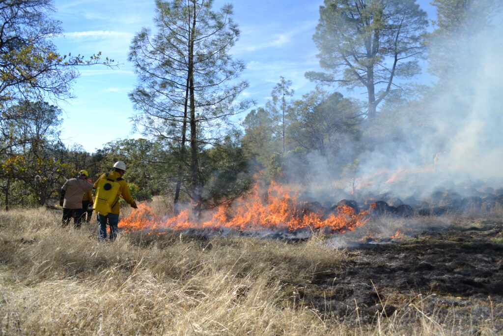
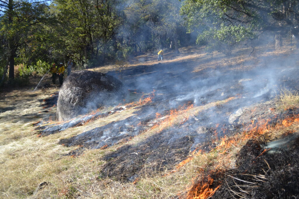
While California takes steps to address forest fire management to reduce the risk of large, catastrophic wildfires, American Rivers is improving forest management and re-establishing fire on the landscape in California’s headwaters to protect clean water for people and nature. Thinning and prescribed fire can reduce forest density, reducing the risk of severe wildfire, while having little or no impact on stream ecosystems. Multiple studies have shown that low- and moderate-severity prescribed fires in montane ecosystems of the Western U.S. have negligible effects on water quality, physical habitat and aquatic organisms, while reducing the danger of catastrophic wildfires and improving wildlife habitat.
In partnership with Sequoia National Forest and Terra Fuego, American Rivers has used prescribed fire on 225 acres, with another 500 acres in planning, along the gateway to Sequoia National Park. We are also pursuing planning for fuels reduction and prescribed fire for 900 acres directly adjacent to the South Yuba River, which would protect adjacent foothills communities and safeguard water quality and supply for communities in the Central Valley. In order to scale up this work, we are also partnering with graduate students from UC Santa Barbara to develop a method to prioritize fuels reduction projects that most benefit rivers and water supply. This work will reduce wildfire risk, improve ecological values, bolster community resilience and protect California’s rivers and water supply.
Like a zombie, the Pebble Mine project in the Bristol Bay watershed in Alaska, has been the project that just will not die.
We thought the project was dead back in 2014 when the Obama Administration’s Environmental Protection Agency (EPA) preemptively vetoed it using its authority under the Clean Water Act. However, the Trump Administration’s EPA reversed the veto in 2019 after initiating a fast-tracked environmental review process in 2018.
Last month, the EPA announced the results of that environmental review process. Reversing its earlier findings, the agency concluded that the project poses no serious environmental risks to the rivers of Bristol Bay watershed (a dubious claim, to be sure). It seemed that the EPA was paving the way for the U.S. Army Corps of Engineers to issue a permit for the project.
Fast forward to this week. In a surprise move, the Army Corps sent a letter to Northern Dynasty (the company that wants to build the mine) stating that it must figure out how it will mitigate for “all direct and indirect impact” to rivers in the Bristol Bay watershed. This letter follows vocal criticism of the project by President Trump’s son, Donald Trump, Jr., as well as Fox News personality Tucker Carlson, who have both fished Bristol Bay. In another surprise move, Alaska’s two U.S. senators, Lisa Murkowski and Dan Sullivan, expressed strong support for the Corps’ stunning turnabout.
While uncertainties about Bristol Bay’s future remain, one thing is certain: American Rivers will continue to support the indigenous communities, conservation organizations and anglers who oppose this project — until it goes away for good. We included the rivers of Bristol Bay in our America’s Most Endangered Rivers® report three times— in 2006, 2011, and 2018. And we’ll continue to help our partners keep the pressure on until this pristine watershed is safe from harm.
The Nushagak and Kvichak rivers, including tributaries such as the Koktuli, Mulchatna and Talarik rivers, are home to one of the last great wild salmon runs in the world, and host world-class rainbow trout, char and other freshwater fish.
Returning salmon have been the cornerstone of the Yup’ik, Dena’ina, and Alutiiq people’s cultures for thousands of years, still providing physical and cultural sustenance for the region’s more than 7,000 residents spread out across a region the size of Ohio. The rivers of Bristol Bay not only sustain local communities, but they also support countless wildlife species that thrive in the region, from marine mammals to waterfowl to brown bears. The Bristol Bay salmon fishery supports 14,000 sustainable American jobs worth $1.5 billion annually.
The Bristol Bay watershed provides habitat for at least 29 fish species, 40 terrestrial mammal species and 190 bird species. The area attracts tens of thousands of tourists each summer. Sport fishing results in more than 29,000 angler trips per year, and salmon-dependent wildlife such as brown bears attract thousands more. Just downstream from the Pebble Mine site lies Lake Iliamna— Alaska’s largest freshwater lake and home to one of two known freshwater seal populations in the world.
As river advocates, we care deeply about all of these things. That’s why we will remain vigilant until the Pebble Mine is finally put to rest.
Fresh grizzly tracks wandered onto the trail less than a mile from Marias Pass. They wove in and out of the deep, muddy tread, following a wide cut through thick lodgepole pine, all the way down to the South Fork of the Two Medicine River. My pup, Naki, and I crossed through the current as the first tendrils of rosy-gold light touched the ridgeline above and set up camp while the water turned orange under a midsummer sunset. I sat down on the bank and took a deep breath, closing my eyes as I let it out. The world’s been growing louder lately, and it felt good to let the sounds of the river take over for a while.
I grew up hearing about the Badger – Two Medicine from both sides of my family. As a descendent of the Pikuni People (Blackfeet) on my mother’s side, I learned to respect these ridgelines and river valleys as sacred land; a sanctum of ceremony and stories that have shaped our People for thousands of years.
Some of those stories remain, painted onto wind-worn lodges and woven into the intricately beaded belts and dresses of our People. Many of them have been lost throughout the decades, but I’m told their words are still here, spoken by the wind and scattered like seeds across the landscape.
When I was a kid, my sister and I loved to sift through piles of freshly dug dirt near the gopher holes in former Pikuni campsites, searching for the same colorful seed beads our great, great grandmothers used to weave colorful pieces of our family story onto bison leather. Finding them felt like finding the words – the seeds – of those old stories lost to time and change.
My father’s family history tells another story of this area. His great grandfather was one of the first miners to stake a claim near the town of Alton, which now rests at the bottom of Sherburne Reservoir. Though he never had much luck mining, he and his wife did raise 18 children including my great grandpa, Cyril, on the edge of what’s now Glacier National Park.
Cy and his siblings grew up poor and most without more than an 8th grade education, but Cy’s aptitude for tinkering with and fixing things eventually landed him a job as the Chief Engineer for the Glacier Park Hotel Company. He and my great grandma raised my grandpa and his sister in East Glacier where they learned to fish along the Two Medicine River and developed a deep love for the wild country out their back door; a love that eventually led my grandpa to a 40-year career with the Forest Service.
Those years took my grandparents and their five children from Montana, to Alaska, and back again. Still, after so much time and with so much wild country under their boots, my grandparent’s favorite stories to share are those that were born along the forks of the Two Medicine River and in that special country where the mountains meet the prairie. Each summer, with the exception of this year, they gather our family in East Glacier to celebrate one another and the wild places that have shaped us for so long. Even through these uncertain times, unable to gather in those places, this land offers a familiar and comforting embrace.

The air was cool as Naki and I set off the next morning, following the trail as it dipped and rose towards the headwaters of the South Fork of the Two Medicine River and the heart of the Badger – Two Medicine. Signs for High Water Trail No. 101.1 pointed off into hillsides thick with young vegetation and fire-scarred logs that lay like pick-up sticks across the faint remnants of an old contour trail.
I wondered what the river looked like when my Niitsitapi (Blackfoot Confederacy) ancestors first felt the power of this place, and how its channels had changed by the time my European ancestors hung trail signs here. Somewhere deep in my heart a fire burned with the hope that future generations of my family might be able to trace their roots back to the same wild waters and tell their own stories of this place.
I thought about a dearly missed friend and author who once said, “Listen hard, lest I miss the message when the mountains speak.” As the world grows louder, it seems harder and harder to hear that message. Too often are the whispers of the mountains and ramblings of the rivers drowned out by tales of conquest and accounts of development in the name of progress, all so that we might move a little faster through the landscapes we no longer know in the same ways. But, in the Badger – Two Medicine, the message of the mountains and the voices of the people who call it home have risen up.
After a decades-long fight to protect the Badger – Two Medicine from oil and gas development, these rivers and ridgelines are closer than ever to being protected in perpetuity. A bill recently introduced by Senator Jon Tester (D-MT) seeks to designate over 127,000 acres of sacred cultural land, vital wildlife habitat, and pristine, free-flowing rivers under the Badger – Two Medicine Protection Act.
The Badger – Two Medicine Area is an incredible, unprotected swath of wild country, encompassing the headwaters of Badger Creek and the Two Medicine river south of Glacier National Park. It is considered to be the sacred backbone of Blackfeet culture, knowledge and identity, as well as home to grizzly bears, elk, wolverines, and native fish. After years of work, the Blackfeet Nation and its partners created the proposed Cultural Heritage Area to protect the cultural and environmental values of the Badger – Two Medicine. If enacted, this legislation would conserve the largest remaining, unprotected public lands in the Crown of the Continent ecosystem, while simultaneously honoring the Blackfeet Nation’s deep connections to this sacred area, and vital role in the area’s long-term management. Badger Creek, the South Fork of the two Medicine River, and their tributaries are among the many free-flowing rivers protected under this legislation from the lingering threats of oil and gas leasing, dams, and other harmful development.
This landscape has shaped my family for generations, and continues to form my land ethic, inspire the work I do, and mold the person I am. Mine is but one of the countless stories rooted in these hillsides and there are so many more to be told, if we listen hard.
Naki and I paused by the river for a few minutes, staring into the clear, cold current. There’s a clarity there, in the rhythmic wildness of rushing water; a steadiness amidst the rumble that never fails to calm my racing mind and bring me home.
To learn what you can do to help protect the Badger – Two Medicine, contact jstevenson@americanrivers.org.
As I have traveled around the country over the past nine years speaking to American Rivers supporters, I’m often asked what is the most important thing a person can do for rivers? My answer is always the same: vote.
Voting is our most precious right and important responsibility as citizens. Whether we are concerned about the impact of stormwater runoff on our favorite local stream, securing permanent federal protection of a Wild and Scenic River in our state, or addressing the threats posed by global climate change to our nation’s rivers, voting is the way to effect change.
It seems like every election is described as “the most important election in our lifetime.” In 2020, though, I think hyperbole matches reality. In a year in which we are experiencing the worst global pandemic in a century, the greatest economic decline in nearly a century, and civil unrest spurred by four centuries of racial injustice, the stakes in this year’s election couldn’t be higher.
So, if you want to make a real difference for rivers and clean water, here are three simple steps to take:
- Make sure you are registered to vote in your state. Go to www.vote.org to check your voter registration and, if you’re not registered, find the link to your state’s board of elections to register online.
- Make a plan to ensure you vote on or before November 3. With health concerns associated with the pandemic, many people are opting to vote by absentee ballot or in person at early voting centers. You can register to vote, request an absentee ballot, and locate your polling place using the links at www.vote.org. No matter how you decide to vote, just be sure to vote.
- Learn about the candidates and their positions on rivers, clean water, and any other issues you care about by reading newspapers and online media, following the news, and looking at campaign websites. Then make an informed decision and vote for candidates who share your values on protecting and restoring healthy rivers, conserving clean water, and other issues you care about.
Remember, the only vote that doesn’t count is the one that isn’t cast. Be sure to cast your vote on or before November 3.
We live on a water planet, but 97.5 percent of earth’s water is too salty for human use. Only .5 percent of fresh water is actually available to us – most of it is locked up in ice caps and inaccessible aquifers. This makes our rivers and streams incredibly valuable. They are the veins and arteries of our country. People have always been drawn to river banks – to live, farm, trade, travel, hunt, fish, play. Water is life, and all life needs rivers.
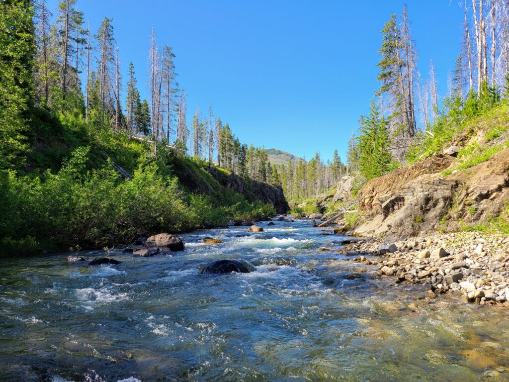
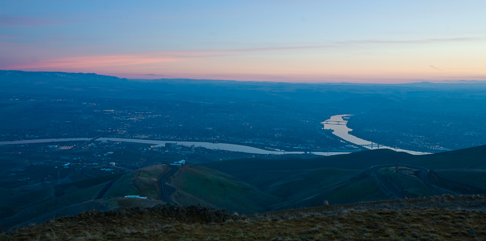
In the Pacific Northwest, one of our most important lifelines is the Snake River. More than 1,000 miles long, the Snake starts in western Wyoming and flows through southern Idaho, carves Hells Canyon on the Idaho-Oregon border, winds through eastern Washington’s Palouse and joins the Columbia River in Pasco, WA.
Over the years, this river has been loved, used and abused. But rivers are resilient and can rebound. Native American tribes, state and federal agencies, non-profits and others are undertaking efforts throughout the Snake River watershed to improve habitat and water quality. An exciting effort is on the lower Snake River mainstem in eastern Washington, where we have a chance to bring a 140-mile stretch of river back to life. Diverse voices across the Northwest are calling for a solution that removes four dams on the lower Snake River to restore a free-flowing river and bring back healthy, harvestable salmon and steelhead runs, while investing in clean energy, agriculture and other infrastructure to bolster the region’s economy.
Can we imagine a healthy, free-flowing lower Snake River that connects and strengthens our communities? Can we remember what the lower Snake River was like before the dams were built, and can we create a shared vision for the future?
Louis Reuben is Nimiipuu (Nez Perce). His great-grandfather was born by the river, at a place called Wawawai. That place is underwater today, just upstream from Lower Granite Dam. When the dam was built, it flooded this and countless other sites central to people’s lives and sacred to the tribe’s culture. “I have never been able to show my son that place — because it’s underwater,” Louis says. “The dams flooded out mine and many others ancestral homelands and burial sites. I don’t only seek justice for my people, I seek environmental justice. Everything is connected, from the grizzly bears to the orcas. No species has the authority to change the environment when only themselves benefit. It is important to correct what’s been wronged.”
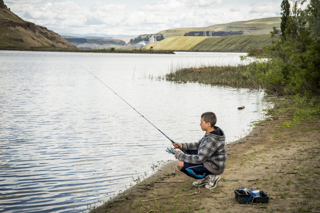
Curt Chang, a river guide with OARS, writes that restoring a free-flowing lower Snake River would “safeguard our outdoor economy in Idaho and breathe new life into a struggling economy here in Lewiston. Freeing 140 miles of river will restore recreation around Lewiston as well. We used to be able to walk down to white sandy beaches rather than levees. We used to be able to fly fish on our lunch hours, take a dip in a clean and healthy river.”
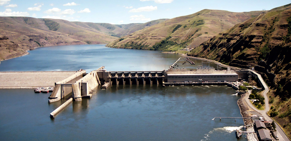
Restoring the river would uncover once-popular swimming beaches. Before Lower Granite Dam was built and the river backed up in 1975, there was a sandy beach that locals enjoyed on hot summer days. Today, the stagnant, slow-moving water isn’t as appealing and can contribute to water quality problems. There are close to 100 rapids under the lower Snake’s four reservoirs. Restore a free-flowing river, and many of those rapids will reappear, drawing paddlers and boaters from across the region.
We could once-again have a river that’s inviting, a natural asset for all to enjoy. River restoration could create a beautiful new network of waterfront parks and trails. Think of the new riverside public lands that would be available for hiking, biking, hunting and fishing and other recreation and adventure. And think of the local businesses – from hotels, restaurants and breweries to retail and other services – that would develop to support these activities and visitors. A reborn lower Snake River would be at the top of the bucket list for outdoor explorers, families and nature-lovers.
People aren’t the only ones who would benefit from a revitalized river. Salmon and steelhead runs would rebound, a keystone to the entire web of life. The riparian habitat (the trees, grasses and shrubs along the river’s edge) that would re-emerge as the river is restored with dam removal would benefit a wide variety of species. According to the National Park Service, riparian areas in the West provide habitat for more species of birds than all other western vegetation combined. And, 80 percent of neotropical migrant species (mostly songbirds) depend on riparian areas for nesting or migration. The lower Snake River could be transformed into a vibrant ribbon of life.
We’ve seen rivers rebound before. Hundreds of dams have been removed on rivers across the country. With a little help, rivers can heal themselves. The banks green up quickly with vegetation. Nutrient laden sediment that was backed up behind the dams would once again contribute to the form and function of the river.
Life returns.
We believe we can realize a vision of a healthy, free-flowing lower Snake River. But it can’t be our vision alone. It must be shared, created by everyone who cares about the river, who benefits from its water and power and salmon. We all stand to gain from a healthier river. Let’s get to work.

