Can giving rivers room help keep communities safe?
Opening the weir safely accommodates large floods while also providing a variety of other benefits for people and wildlife, but more should be done prevent catastrophic floods on the lower Sacramento and San Joaquin Rivers.
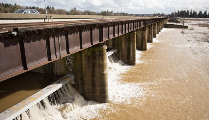
On Tuesday morning, the California Department of Water Resources (DWR) opened the Sacramento Weir to make more room for the Sacramento River to safely accommodate flood flows from the recent rains. This is the first time DWR has opened the weir since the flood waters of early 2005.
American Rivers and our partners have been working with DWR and the Central Valley Flood Protection Board (CVFPB) on a new plan to give the rivers of California’s Central Valley more room so that they can safely accommodate large floods while also providing a variety of other benefits for people and wildlife including clean water, open space, recreation, trails, water supply resiliency, and habitat.
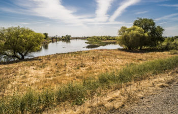
View of likely location of new upstream weir to help flood flows from the San Joaquin River flow into the expanded bypass, thereby relieving stress on downstream structures and communities while also providing improved floodplain function and more habitat area. | Daniel Nylen
DWR and the CVFPB released the Draft Central Valley Flood Protection Plan (CVFPP) 2017 Update last week. The Draft Plan includes two exciting, new multi-benefit flood management projects that will give the rivers more room to reduce flood risk for people and, if designed correctly, provide a number of other benefits including improved habitat for endangered salmon.
The plan proposes to expand the Yolo Bypass on the lower Sacramento River and create a new flood bypass on the lower San Joaquin River. American Rivers has been involved in planning and advancing both projects over the last decade and will be reviewing and commenting on the 2017 plan over the next six weeks. Over the last six months, American Rivers has obtained $4 million in state grants from California Proposition 1 to purchase flood easements necessary for the new flood bypass on the lower San Joaquin River.
The Draft 2017 CVFPP Update is the culmination of over two decades of flood management reform in the wake of the 1997 flood discussed in my previous blogs, the Jones Tract failure of 2004, and Hurricane Katrina in 2005. All of these floods were a wake-up call, but it took the tragedy of Katrina to prompt the California voters to pass a bond measure in 2004 to upgrade our flood defenses and for the legislature to pass a series of reform bills in 2007. Sacramento and other Central Valley communities were and are at greater risk of catastrophic flooding than New Orleans. Thanks to the flood bond generously provided by the voters, we have made some good progress protecting vulnerable communities – particularly in Yuba and Sutter Counties, but implementing the reforms has been like moving a super tanker.
The idea of giving rivers enough room to safely convey floods is not a new idea. The first state flood plan prepared by William Hammond Hall in 1880 for the California legislature recognized the need to accommodate the monster floods that originate from atmospheric rivers colliding with the Sierra Nevada. Unlike the Mississippi River that originates near the Canadian Border and flows over 2,300 miles to the Gulf of Mexico, the rivers of the Central Valley originate at 10,000 to 14,000 feet and drop to sea level in a distance of only three to four hundred miles. The resulting volumes of water rightly humbled William Hammond Hall and other 19th Century flood planners.
Robert Kelley quotes text from Hall’s 1880 plan in his seminal history of flood management in the Central Valley – Battling the Inland Sea:
“Let it also be remembered that this plan applies…to the case where we deal with the ordinary floods of the valley, for no limit may be assigned to the amount of water which may at some time in the future come down this valley; and, as in the past there have been phenomenal inundations, now spoken of as “the flood of ’62,” “the flood of ’52,” etc., so may there yet be others as great or greater than they against the general spread of which no human foresight can provide, nor secure protection for the great body of the lands in the valley.”
Robert Kelly continued to explain Halls observations:
“Limited locations, Hall remarked, such as cities and towns could be raised in elevation or so well protected by high levees that they could probably be permanently protected. And yet, he observed wryly in one of his alarming asides, experience showed that there were two classes of levees: those that had been overtopped by floodwaters and those that were going to be. He continued: ‘And so it should be fully understood that floods will occasionally come which must be allowed to spread.’ But they must be allowed to do so not in their ordinary way, by opening out crevasses in the levees, but by putting strong weirs at several locations so that outflows could occur without causing damage. . .”
The legislature ignored this recommendation. Instead they followed the politically popular advice of other engineers who insisted it was possible to control the rivers with levees so that businessmen and farmers could develop the floodplains. It wasn’t until the devastating flood of 1907 that state leaders followed Hall’s advice and advanced the flood bypass plan developed by Hall’s two protégés – Manson and Grunsky – who by this time operated an engineering firm in San Francisco. With the assistance of the US Army Corps of Engineers (Corps), it took another 20 years to start to implement the plan on the ground.
The Sacramento Weir and the Sacramento Bypass were the first elements of the new plan constructed in 1926 and in the following decade several other weirs were constructed to release flood flows into the Butte Basin and the Sutter and Yolo bypasses. These other elements may have been constructed sooner if it wasn’t for the great flood of 1927 on the Mississippi River, which diverted the Army Corp’s attention away from California. The Corps appears to have taken lessons learned in the previous two decades of planning in California and applied them along the Mississippi in the aftermath of the 1927 flood. The design of the Bonnet Carre spillway, which was constructed in 1928, is almost identical to the Sacramento Weir. And the overflow basins designed to accommodate large floods – the Morganza and New Madrid floodways – are analogous to the Sutter and Yolo bypasses.
Unfortunately, in the second half of the twentieth century, Californian’s and their leaders forgot these lessons and redoubled their efforts to control the rivers of the Central Valley with dams and levees so that cities could grow onto the floodplains as fast as developers could build them. The floods of 1986 and 1997 exposed this folly, but it took Hurricane Katrina to catalyze true reform and another ten years of planning to return to Hall’s original idea – give the rivers enough room to safely convey the inevitable floods that nature will produce. Due to the larger floods that climate change has and will bring, it is now urgent to expand floodways on both the lower Sacramento and San Joaquin Rivers to prevent catastrophic floods in metropolitan Sacramento and Stockton.
In the early part of the 21st Century, researchers from UC Davis and DWR discovered the value of inundated floodplains on the bypasses for California’s native fish and wildlife. Juvenile salmon that rear on floodplains grow three times as fast as juvenile fish that grow in the river channel, and bigger juvenile salmon are far more likely to survive their journey to the ocean and back.
Moreover, primary and secondary productivity from inundated floodplains provide foodweb resources critical to the support of the river ecosystem. Restored floodplains and wetlands also filter polluted waters, recharge depleted groundwater basins, and provide habitat for the millions of migratory birds that overwinter in California’s Central Valley. Giving rivers more room is not only essential to protecting people from flood waters, but it also helps keep rivers healthy for fish and wildlife.
Fortunately, the recent rains are coming to an end this upcoming weekend without another large storm and the potential for catastrophic flooding. This week’s precipitation has arrived mostly in the form of snow down to elevations of 4,500 feet rather than flood-inducing rain falling at high elevations. The reservoirs are now filling in an orderly manner and hopefully another storm will not occur before this week’s floodwaters recede. The lessons from the last century teach us that change takes time and political will. We will need both if we are to successfully implement the 2017 CVFPP Update in preparation for the future floods that climate change will bring.




1 response to “Can giving rivers room help keep communities safe?”
It’s likely that the whole Central Valley of California was often an enormous springtime/seasonal lake/wetland….filled with millions of birds, fish and other wildlife for thousands of years….until altered by man and/or changing climate.
The Amazon River in South America….which is still a largely undammed river on the mainstream…..seasonally turns into an enormous freshwater lake hundreds of miles long as it floods over it’s banks….when annual heavy rains come.
This enormous lake provides habitat for some of the largest and most abundant freshwater fish in the world to breed and feed. Unfortunately there are now plans by the Brazilian government to dam MANY large tributary rivers of the upper Amazon River….this will be a great threat to the Amazon’s pattern of seasonal flooding…..which has been happening for millions of years and is extremely beneficial to wildlife and trees/vegetation in the Amazon River floodplain/basin.