Good News, Bad News at Oroville Dam
The reservoir behind Oroville Dam in California is expected to fill early Saturday morning. Here are the risks involved in that happening.

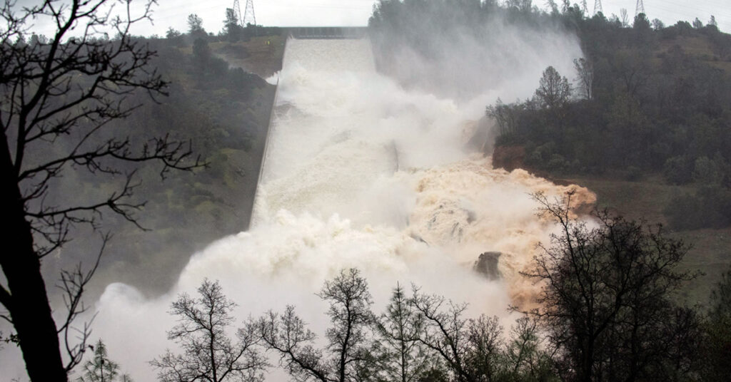
By now you may have read the alarming news about the spillway at Oroville Dam – a 770-foot tall engineered earthen dam, the tallest dam in the United States and one of the tallest earthen dams in the world. The reservoir behind the dam is expected to fill early Saturday morning and potentially spill over an emergency spillway that has never been used since the dam was completed in 1968. As one twitter user observed, “the emergency spillway is basically a hillside.”
The good news is that the weather is clearing today with sunny weather forecasted into the middle of next week. Peak inflows into Oroville Reservoir are receding rapidly. Experienced engineers from the California Department of Water Resources and the Central Valley Flood Protection Board have assured the public that there is no risk of dam failure. Since yesterday afternoon, inflows have decreased from 185,000 cubic feet per second (cfs) to 140,000 cfs this morning, while outflows were ramped up to 65,000 cfs using the damaged spillway combined with the power house outlet.
There is a good chance that inflows and outflows will achieve equilibrium by some time this weekend. This morning, the reservoir was holding 3,461,356 acre feet of water, which is 98 percent of capacity. At current net inflows, the reservoir will start spilling onto the emergency spillway early Saturday morning, but if inflows continue to recede, the flows into the emergency spillway should be relatively small and short-lived. That is the good news.
The bad news is that more rain is forecast for next week. If the reservoir fills before the next peak, which is still a big if, all inflow to the reservoir would flow out over the spillway and into the Feather River. Depending on the size of the next runoff event, this could be a big problem not only on the emergency spillway, but for the downstream communities along the Feather River, particularly Marysville and Yuba City. The National Weather Service reports that next week the “wet pattern returns Wednesday into next weekend as models show another series of storm systems moving across California.” They are currently forecasting moderate rain, but if they upgrade that to heavy rain, we are in trouble.
Inflows to the reservoir peaked at 190,000 cfs this week. If the reservoir had been full, all of that 190,000 cfs would have flowed down the untested emergency spillway and into the Feather River floodway, where it would be joined by another 10,000 cfs or more from local drainages. The design capacity of the floodway is 210,000 cfs and would have theoretically been able to accommodate such an event, but it would have been 25 percent larger than the record flood of 1997 that peaked at just over 150,000 cfs below Oroville Dam as reported by Maurice Roos, the former state hydrologist.
That flood as reported here breached the levee, killed 3 people, destroyed 322 homes, and triggered the evacuation of 38,000 people. If the reservoir had been full when the 1997 peak reservoir inflow of 300,000 cfs occurred, the ensuing destruction would have made Hurricane Katrina look feeble.
I will end with some good news: since 1997, local, state, and federal governments have worked effectively with each other and conservation organizations to give the Feather River more room to accommodate the large floods we know that climate change will bring. Instead of denying climate change, state leaders of both parties worked together to marshal taxpayer support for Proposition 1E in 2006 after the nation witnessed Katrina. Thanks to effective government partnerships, levees and floodways have been significantly improved around Yuba City and Marysville and the floodway has been significantly expanded along the Feather River where floodwaters previously backed-up at a bottleneck in the system.
Levee setback projects at the confluence of the Bear and Feather Rivers, Star Bend, and along seven miles of the east bank of the Feather River have given the river more room to accommodate any additional floodwaters the next few weeks or decades might bring as we adapt to a changing climate.
These projects not only save lives, but they provide multiple other benefits that improve the quality of life for people living in the region. They improve water quality, provide open space and recreational opportunities for local communities, and improve habitat for fish and wildlife. Due to taxpayer investment after Hurricane Katrina, flood agencies have successfully worked with American Rivers and other conservation groups to identify many additional multi-benefit projects across the Central Valley that are necessary to protect lives and safeguard our economy in an era of climate change.
Unfortunately, Proposition 1E is now fully spent and committed. If we are serious about protecting our rivers and communities from a changing climate, we will need to find additional funds and work cooperatively to make sure they are spent effectively.


9 responses to “Good News, Bad News at Oroville Dam”
do you think that people in stockton should have mandatory evacuation for the older people ?
Where does the overflow go? Does it flow out to the ocean or is it collected downstream for agriculture or other human use?
Thanks
If damn fails can it make its way to Merced, Ca
tell me again where is it ” Safe ” place to go, till the whole Mess is over ??? one who is clueless
Can an authority tell a concerned public the mandatory evacuation is Completed? Are all persons moved out of possible harms way…now?
I whipped up a quick little model that estimates the hourly change in lake level based upon the difference between hourly inflow and outflow rates. By extrapolating the observed downward trend in inflow, and assume outflow remains constant, I get overflow of the emergency spillway tomorrow morning….but just barely….peaking at less that 902 ft. (It overflows above 901 ft.) So, I see why they are now saying it might not overflow. Gonna be a full reservoir though!
WE here at Lake Powell Page Ariz”ha a similar Wake up call. Lake filled and underground spillways failed.Bu rec.know how to fix spillways;called “CAVITATION MITIGATION” They cut slots in concrete and tie into large vent pipes that are up and out.This allowed are into at certain levels and stopped the water “hammer”. They have since came out to our Lake and had it fixed with slots. This being in Colorado.
ThatOroville is a tough one to fix because of the Rock ledge under but it can be done
Good Luck DON IN CEZ.
In this article in states “If the reservoir had been full when the 1997 peak reservoir inflow of 300,000 cfs occurred, the ensuing destruction would have made Hurricane Katrina look feeble.”
I looked up the Oroville Dam on Wikipedia, and the spillway capacity is 250,000 cfs. So, my question is, what happens when the lake is full pool and the river goes up to 300,000? I guess that’s the “ensuing destruction” part. How much snow pack is left? How much warm rain is on its way?
Dean Buchser. Talent, Oregon
Update 7:00 am Saturday morning:
The Oroville reservoir level is about 3 inches below the level at which water starts spilling out of the emergency spillway. This is the spillway that releases water onto an unprotected hillside. Massive erosion is likely.
At the rate it Oroville reservoir is filling, water should begin to flow out the emergency spillway before 9:00am, and the flow could reach well over 15,000 cubic feet per second.