Citico Creek: After 50 Years, a River Restored
After 50 years, a dam preventing natural movement of fish on Citico Creek was removed - the result of a new partnership between American Rivers and the U.S. Forest Service.

Originally published on Nooga.com.
The Cherohala Skyway is a scenic drive that winds 40-plus miles through the Cherokee National Forest and Nantahala National Forest from Tellico Plains, Tennessee, to Robbinsville, North Carolina. This popular drive offers expansive views of mountain ranges piled on top of mountain ranges that bathe in the sun’s golden rays and burst with fall color.
Imagine standing at scenic overlooks like Turkey Creek or Brushy Ridge and the landscape turning digital. Pins would pop up everywhere to mark what lies below the canopy, the little nooks and crannies of wonder and diversity that make this Appalachian landscape unique: waterfalls, swimming holes, trails, camping sites, waterways, and habitat lush with plants and animals found only in this environment.
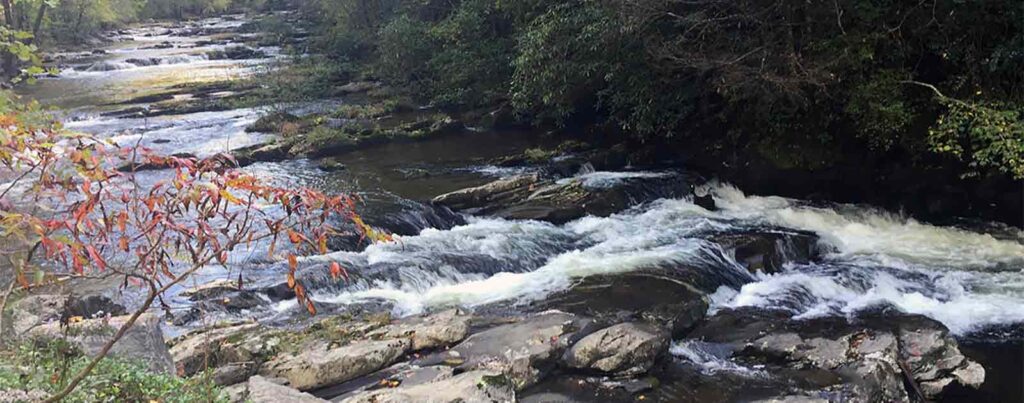
Surely one pin would designate Citico Creek, a pristine waterway that originates high in the mountains of the Citico Wilderness and eventually empties into Tellico Lake. Located deep within a gorge, the creek is accessed from FS Road 345, which leads to Indian Boundary Lake and Campground, about 15 miles from Tellico Plains.
Citico Creek is designated an exceptional Tennessee stream by the Tennessee Department of Environment and Conservation because of the rich diversity of fish that live within its waters. Fifty-two native fish live in Citico Creek, including the federally endangered Citico darter (a small fish) and Smoky madtom, and federally threatened yellowfin madtom (madtoms are small catfish).
Follow the curvy mountain road that leads to Citico Creek and you will arrive at Doublecamp Campground, a backcountry camping area along its riverbanks. There, 50 years ago, a low dam was constructed in a misguided effort to prevent warm water fish (including green sunfish, bream and creek chubs) in Indian Boundary Lake from migrating into the trout waters of Citico Creek. Today, biologists understand that this was an error—warm water fish cannot survive in the cold water of Citico Creek and therefore pose no threat.
Water tumbles over the manmade structure, and each fall, some fish drama takes place there: Brown trout can be seen leaping out of the water, throwing their bodies against the obstruction in an effort to travel upstream to spawn. No doubt this has been going on since the dam was built nearly 50 years ago.
This week, a track hoe and hydraulic hoe ram changed everything in this little nook and cranny of forest. Thanks to a partnership between American Rivers, Region 8 of the United States Department of Agriculture Forest Service, the U.S. Fish and Wildlife Service, and the Cherokee National Forest, the dam was removed.
“[Citico Creek dam] is the first dam removal to take place as part of a new partnership between American Rivers and the southern region of the U.S. Forest Service,” said Gerrit Jöbsis, senior director of conservation programs with American Rivers, a national river conservation organization.
“Most of our work focuses on dams that are not being used and are causing harm, risking public health and impacting aquatic species,” Jöbsis said.
For half a century, Citico Creek dam prevented the natural movement of fish in the waterway, segregating species into upstream and downstream populations, and decreasing genetic diversity and resiliency. It also interrupted the natural transport of sediment and nutrients required in healthy streams.
“The dam removal along Citico Creek will benefit 13 species specifically,” said Allison Reddington, USDA Forest Service hydrologist with the Cherokee National Forest.
The Citico Creek dam removal began Tuesday. Agency staff watched as a hydraulic hoe ram chipped away at concrete and rebar. Finally, after a half-century, Citico Creek is a river restored.


5 responses to “Citico Creek: After 50 Years, a River Restored”
Well now you know the truth.
That would have been the telllico lake dam.
I’m working on a memoir which chronicles my 11-year stint (1975-1986) at Riverbend School, an innovative 90-bed inpatient mental health program for troubled children and youth located on the grounds of what was once known as Eastern State Mental Health Institute, and later named Lakeshore Mental Health Institute in Knoxville, TN. While working with the Zodiacs (13-15yr old seriously emotionally disturbed girls treatment group), we took a 4-day canoe trip down the Little T (sometime between 1976-1977). According to Michael Burke, one of my teammates and a genuine mountain man / old Hippie and gifted teacher-counselor, our trip was historical in that it was one of the last opportunities to canoe the Little T before it disappeared, thanks to the “progress of man” at that time… i.e. the building of a dam. I remember a bumper sticker that I had on my old Ford Fairlane — “Save the Little T.” Up until now, I’d found no record of the Little T being destroyed. Thanks to this 2015 article, my recollection of our canoe voyage is apparently correct — A portion of the Little T was wiped out via the Citico Creek dam, although, if true, the dam was built 42 years ago? If anyone can shed more light on this, I would greatly appreciate… It was an adventure, that 4-day float trip. Each night we would set up camp along the river. I vividly recall Michael and I waking up on the last day, looking at each other, and simultaneously bolting down the hill and into what was, and remains to this day, the coldest water I’ve ever encountered.
Glad to have these fine people making efforts to restore the natural ecology of our area waterways. Thanks folks.
We can only hope our new President does not attempt to reverse this trend of ecosystem restoration, or worse, display disrespect for both the lands these projects are being done on, and the public who owns these lands.
So happy to see that you are making a positive impact in our beautiful Southern Appalachians. Please keep up the good work, and keep me posted about other projects in the Southeast.